Tag: Expert Advice

  • Expert Advice: Availability Gaps: Solutions for Aviation

    Directions 2010

    James L. Farrell
    James L. Farrell

    By James L. Farrell

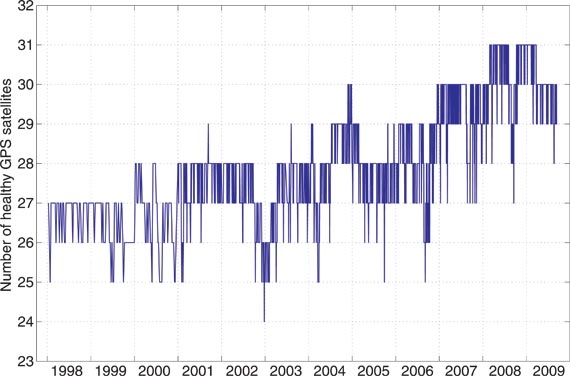
    Recent attention given to aging GPS satellites and availability gaps from lagging constellation replenishment have provoked deep concern, particularly within the aviation community. Available remedies include exploitation of well known but unused methods plus new techniques; those discussed here have future relevance, with or without availability gaps.

    Even with far greater coverage from multiple GNSS, crises could emerge from severely stronger interference levels or other unforeseen events. Advance preparation for any such occurrence would avoid the waste, confusion, and blind alleys that generally arise with the sudden appearance of an emergency.

    GPS lives up to expectations, brilliantly performing as advertised. Even that best-ever performance must and does have tolerance for occasional error; examples, though rare, are well documented. To live with less than perfect performance, the industry relies on integrity testing: comparison checks using extra satellites to detect inconsistencies and exclude questionable data.

    Nevertheless, it is universally recognized that GNSS, even with existing fault detection and isolation or exclusion (FDI/FDE), is still not perfect. The ramifications of growing dependence on GPS have thus attracted more attention. The overall subject can be subdivided into general areas involving the likelihood of:

    • reduced availability and
    • reduced dependability (integrity, its verification, plus backup).

    Although I mainly address the first topic here, the second unavoidably intertwines itself, making it difficult to keep them separate. Despite wide acclaim for the excellent 2001 Volpe Report, commitment to a key means of backup for GPS remains unclear at this time. Possibility of a shortfall calls for a review of both existing methods and procedures, and possible means for closing the gap.

    Current Methods

    Today’s air traffic management  designs demand constant replenishment of instantaneous position by full fixes.

    Full Fix 1 RAIM. When each data vector must be a self-sufficient source of instantaneous position, a requirement arises for enough satellite sightline directions with geometric spread at all times. That interdependence is magnified when more satellites are added to provide FDI/FDE, requiring every subset of four within the enlarged group to support the requisite geometry. With this all-or-nothing posture, data lapses form a major stumbling block. A data gap that is only partial equates to a loss of GPS.

    Position-Oriented Approach. Especially at high speeds, as in flight, instantaneous position is highly perishable. With little or no emphasis placed on accurate dynamics (beginning with velocity), demand for continuously accurate instantaneous position is highly dependent on abundant data. That abundance includes sufficiently high data rates, since latency becomes a significant liability without usage of a dynamic file.

    Carrier Phase (Classical). Successful use of carrier-phase information is decades old. Although ambiguity resolution is not required in all carrier-phase applications, requirements for cycle-slip detection are quite common. More common yet — in fact, virtually ubiquitous — is the need to maintain phase continuity via a carrier-track loop. When those needs are satisfied, sub-wavelength instantaneous position is obtainable. Challenges involved, however, have produced among users a wide variation in perception of value. Some negative perceptions have arisen due to cutting corners in formation of carrier phase, or merely settling for delta range, by some receivers. Further, a cycle slip, even if only rarely overlooked, can be catastrophic in some operations.

    Imperfect Validation. As already noted, verification is not my main topic here, but the issue is inescapable. Shortcomings include hard evidence of certification improperly bestowed, and severe limitations of go/no-go criteria (as with an automobile’s dashboard warning lights, we can learn if a performance trait is unsatisfactory — but a trivial excess produces the same indication as an imminent danger).

    Necessary Changes

    Extremely powerful and versatile means to improve performance have been available for a very long time. Kalman’s original paper, half a century ago, formalized an optimal way to achieve such performance. While Kalman estimation is commonly used today, its effective reach is almost invariably limited to data resident within each proprietary box of equipment.

    The resources for providing centrally processed solutions for data from every source of information available, any combination of sources, any subset that may exclude any sensor or group, or any individual source in a federated configuration, are well known. Every conceivable choice from among these solutions can be made concurrently available; note the inherent backup.

    However, all this capability is forsaken or lost by continued use of:

    • interfaces chosen poorly or from outdated standards;
    • undue consolidation within isolated equipment packaging;
    • overextended proprietary rights; and
    • limited, demonstrably flawed validation methods.

    Drop Demands for Full Fix. An immediate explosion of benefits can follow from acceptance of partial information. Countless examples could be cited, but two obvious ones suffice:

    • Within GPS or GNSS, not all space vehicles (SVs) would be simultaneously affected by scintillation; ionospheric disturbance effects vary with both location and time. A similar case holds for multipath. Data from some SVs could be rejected, by decisions made external to a receiver, without forcing rejection of all.
    • Central processing — not within any one equipment box — has always offered potential for other sources (distance-measuring equipment or DME, and so on) to make up for incomplete sets of SV data.

    My broad goal here is to take advantage of information not currently used and to prescribe corrective strategies. That objective has not been widely pursued due to perceived lack of urgency. GPS availability has thus far been more than satisfactory to a multitude of users — but that could change.

    Availability Enhancements. For about two decades, the industry was effectively guided by a strong preference for the trait whereby every data refresh event was self-sufficient. A major reason for this was protection against gradual veering: a snapshot sequence is less sensitive than a continuously evolving path estimate. The cost, of course, is forfeit of benefits conferred by the sequence’s history. More recently, a middle ground was sought to mitigate the resulting loss; subfilters used as much new data as possible while making some use of knowledge from an estimator’s covariance matrix.

    I promptly endorsed that approach and sought to carry it to the limit. A single-measurement receiver-autnomous integrity monitoring (RAIM) resulted, offering an independent integrity test for each separate observation. Despite its rigorous derivation, the technique is quite simple in practice. Further, it bridges a gap that formerly separated integrity test from optimal estimation, while also having significant advantages over conventional RAIM:

    • separation translates to independence from other satellites, and therefore from geometry (effective DOP of unity)
    • ability to use different error variances for different observations (for example, with nonuniformity in signal strength and/or elevation).

    With this discussion, we have clearly left the realm of well-known subjects with self-evident prescriptions. Much of what follows likewise falls into the category of relatively obscure methods.

    Beyond Position-Oriented. A time history
    of GNSS observations, with or without an inertial measurement unit (IMU), inherently carries dynamic information. A file with observational history from multiple sources of course enables the aforementioned explosion of benefits. The obvious immediate offerings include:

    • closing of data lapses via information sharing;
    • intrinsic backup with automatic activation;
    • vast reduction of latency effects (for example, from 200 meters to less than 1 meter at 400 knots after 1 second, with easily obtainable velocity accuracy below 1 meter/second);
    • formation of 1-sigma projected future error (within reason).

    Beyond these lie, once again, some lesser known techniques, including a few that are virtually nonexistent in operation at the time of this writing. With GNSS, the full potential of dynamics calls for a revisit of carrier phase.

    Carrier-Phase Developments. Rather than pursuit of unnecessary sub-wavelength fixes for aircraft (for example, with 20-meter wing span moving at 400 knots), the true value of carrier phase in flight lies in enhanced dependability.  Sequential changes in carrier phase over 1 second provide excellent dynamics information, with or without an IMU.

    Recognition of this opportunity led to the concept of segmentation, whereby position is determined separately from dynamics. Carrier-phase sequential changes with ambiguities unresolved can provide precise (1-centimeter/second RMS with IMU; decimeter/second without) streaming velocity independent of position. Dead reckoning then provides a priori position correctible by pseudoranges.

    One advantage of this scheme is subtle: with 1-second phase change propagation effects generally at 1 centimeter or less, no mask is needed. The geometry benefit is obvious, and flight experience has verified it. This raises another segmentation characteristic: the single-measurement integrity testing is applicable to each carrier-phase sequential change and to each pseudorange, separately and independently.

    These capabilities are untapped in essentially all operational systems — air, land, and sea — and all stand to gain. Yet another opportunity can be added: ability to sustain operation even if every SV has repetitive data gaps. This advantage is best exploited with receivers described next.

    FFT-Based Processing. Correlators and track loops in GNSS receivers can be replaced. The theory is age-old: multiplication in the frequency domain corresponds to convolution in time (and vice-versa). Thus a term-by-term product of a digitized receiver input’s fast Fourier transform (FFT) with the reference pattern’s FFT can, after an inverse FFT, provide outputs equivalent to full sets of correlator responses. Today’s processing and analog-to-digital converter capabilities offer feasibility.

    In addition to reduced vulnerability to jamming (not covered here), advantages include:

    • access to all cells (not only a track loop’s subset)
    • guaranteed access (stability is not conditional)
    • linear phase-versus-frequency; no phase distortion.

    Features from the preceding section, combined with these traits, offer extreme robustness.

    Extension to Surveillance. The practice of transmitting responses to RF interrogations has, for many decades, been quite vulnerable to overload (garble; one user’s information is everyone else’s interference). One report described the unsurprisingly poor performance during the first Gulf War, and identified a remedy: squitters with separate assigned time slots, spontaneously firing the transponder transmitter without interrogation. Immediately, a sea change in capability offers every participant an opportunity to track every other participant. With no interrogations, garble would disappear.

    This dramatic increase in capacity has been successfully demonstrated with the use of an existing communication link and existing airborne equipment: GPS receivers and Mode S squitters. Subsequently I enthusiastically advocated adoption of the technique with one fundamental modification: replace the data bits of the transmitted messages with measurements instead of coordinates.
    Additional improvements include small shifts in time (reducing bits needed for time tags) and recomputation of measurements that would have occurred at the center of gravity (to mitigate rotation effects). Collectively, the full set of procedures offers a vast and compelling list of benefits.

    Conclusions

    Capability and dependability of navigation and surveillance can be enormously increased. The key lies not in new inventions nor provisions, but in use of newer methods, (among them, FFT-based receivers, segmented estimation, and 1-second carrier-phase changes) while abandoning habits such as:

    • dismissal of partial fix data
    • preoccupation with full fixes for instantaneous position irrespective of dynamics
    • preference for location pseudomeasurements rather than the measurements themselves
    • reliance on proprietary software in equipment boxes
    • RF interrogation/response sequences instead of squitters.

    The industry can either adopt changes or continue to settle for performance levels at a minor fraction of the intrinsic capabilities available from our present and future systems.


    James L. Farrell worked for 31 years at Westinghouse in design, simulation, and validation of navigation and tracking programs. He continues teaching and consulting for private industry, the Department of Defense, and university research through Vigil, Inc

  • Expert Advice: GPS Constellation Maxed Out at 30

    Expert Advice: GPS Constellation Maxed Out at 30

    It appears that the GPS satellite constellation has a glass ceiling, so to speak.

    GPS was designed as a 24-satellite constellation, with four satellites in six orbital planes arranged to provide maximum observability around the globe. According to the government’s Space-Based Positioning, Navigation, and Timing website, “The U.S. government is committed to provide a minimum of 24 operational GPS satellites on orbit, 95 percent of the time. The U.S. Air Force launches additional satellites that function as active spares to accommodate periodic satellite maintenance downtime and assure the availability of at least 24 operating satellites. As of August 28, 2009, there were 35 satellites in the GPS constellation, with 30 set ‘healthy’ to users.”

    Figure 1 shows the locations of the 35 satellites. Green squares indicate satellites marked healthy in the broadcast almanac. The numbers displayed are the satellites’ pseudorandom noise (PRN) codes. Red squares, with PRN codes, indicate satellites transmitting L-band signals but currently set unhealthy. Note that SVN24/PRN24, although active, is not included in almanacs. Blue squares indicate reserve satellites with space vehicle numbers (SVNs) in parentheses. Notice the bunching together of certain pairs of satellites. The constellation of 30 healthy satellites is not configured to maximize geometrical performance. Rather it is to help guarantee a minimal level of performance considering that many of the spare satellites are one component away from failure. Basically, the 30-satellite constellation is actually being flown as a 24-satellite constellation.

    Figure 1. Locations of the 35 current GPS satellites: green squares denote satellites marked healthy in the broadcast almanac, satellites marked by red squares transmit L-band signals but are curerently set unhealthy, and blue squares indicate reserve satellites. Bunched pairs show satellites being flown in tandem.
    Figure 1. Locations of the 35 current GPS satellites: green squares denote satellites marked healthy in the broadcast almanac, satellites marked by red squares transmit L-band signals but are curerently set unhealthy, and blue squares indicate reserve satellites. Bunched pairs show satellites being flown in tandem.

    But with 35 satellites in working condition, why are only 30 set healthy? Modern GPS receivers can handle all 32 PRN codes, and many studies have shown the more satellites the better as far as position accuracy and reliability are concerned. In fact, a recent Air Force Space Command article stated, “One additional GPS satellite can make a difference between getting a degraded GPS signal and getting an accurate GPS-based location, whether it is for warfighters in Baghdad or firefighters in Boston.” The current control system should, in principle, be able to handle 32 healthy satellites.

    Ground Control System. But, according to the GPS Wing, the de facto limit is 31 satellites. We don’t know if this is a problem related to 2nd Space Operations Squadron (2SOPS) functions or if there is some military system or equipment platform that cannot tolerate 32 healthy satellites.

    Further, if the de facto limit is 31 satellites, why have we had only a maximum of 30 satellites set healthy since early this year? After all, 2SOPS rightly crowed about having 31 satellites set healthy for the first time on February 27, 2008, when SVN23 was reintroduced into the healthy constellation as PRN32.

    Figure 2, courtesy of Ted Driver at Analytical Graphics, Inc., shows the number of satellites set healthy from 1998 onward, according to the Notice Advisories to Navstar  Users (NANUs) issued by 2SOPS and the almanacs broadcast by the GPS satellites. Often, a satellite is actually set unhealthy for only a portion of the day, but this plot tallies only the number of satellites healthy for a full day. As we can see, off and on through most of 2008 and into 2009, we had 31 satellites set healthy on orbit. With 31 satellites, users benefited from better availability and accuracy and were slightly better able to handle the occasional three-satellite outages due to SVN35/PRN5 and SVN25/PRN25 being set unhealthy for extended overlapping periods.

    Figure 2. The number satellites set healthy since 1998 (courtesy of Analytical Graphics, Inc.)
    Figure 2. The number satellites set healthy since 1998 (courtesy of Analytical Graphics, Inc.)

    But since March 26, 2009, when SVN35/PRN5 was decommissioned from active service, we have not seen a return to 31 healthy satellites.

    Why is that?

    Ground Testing. I asked this question to Col. Dave Madden, the GPS Wing commander, during a panel discussion on GNSS program updates at The Institute of Navigation’s GNSS 2009 meeting in Savannah, Georgia, in September. Apparently, the reason why 31 satellites cannot currently be set healthy simultaneously has do with ground testing of Block IIF satellites. One PRN code is needed for the test satellite on the ground. Presumably this means that testing involves tracking the constellation in space and a IIF test satellite simultaneously.

    So, although everyone acknowledges that more GPS satellites are better, we have hit a 30-satellite ceiling. As IIF satellites are launched and further improvements are made to control system operations, and any incompatible old military systems are replaced or updated, perhaps we can break through this glass ceiling and have 31 or even 32 healthy GPS satellites available to users.

    We can hope.

  • Expert Advice: GPS Forensics, Crime, and Jamming

    Professor Emeritus David Last.
    Professor Emeritus David Last.

    By David Last

    The most widely used of all GPS devices are in-car navigators. When vehicles carrying navigators are used for criminal purposes, records contained in the devices may be examined. Such investigations rely on newly developed forensic techniques that employ a combination of computer expertise and navigation knowledge, yielding valuable data for crime investigators.

    Evidence from GPS-based tracking systems now fitted to a wide range of vehicles can be of even greater value. These installations, many of them covert, provide a history of vehicle movements. Forensic analysis of such records can provide evidence of considerable value in crime detection.

    Whilst the principal purpose of vehicle-tracking systems is generally to provide real-time information for efficient fleet control, they also serve an important security function. By continuously displaying up-to-date location information and identifying vehicles that deviate from planned routes or cross specific boundaries, they help protect assets that include the vehicles themselves and their high-value contents. Vehicle-tracking systems now constitute one of the most important GPS applications for our society.

    The recent appearance of readily available, low-cost GPS jamming devices presents a real and immediate threat to all such tracking and security systems. Criminals now employ jammers that can block both GPS reception and GSM in Europe, and U.S. and other mobile phone systems throughout the world, rendering vulnerable the use of GPS in critical security applications. Other global satellite navigation systems (GNSS) in development will likely share that vulnerability. While not yet deployed for criminal purposes, spoofers that mimic GNSS signals will pose an even greater threat to vehicle security than jammers.

    Alternative technologies, including enhanced Loran (eLoran), for vehicle navigation and tracking are not vulnerable to these threats, and promise a degree of protection to vehicle-tracking and recovery systems. These solutions will likely play an increasing role as GNSS jamming and spoofing activity increases.

    Vehicle Navigators

    Vehicle navigators often contain large numbers of records created by their users. These may show where they have been, how they got there, and a great deal more of value to investigators.

    The destinations stored in car navigators can be extracted, listed, and plotted. It is now possible to do this for virtually all makes and models of device, whether after-market installations or built in by the manufacturer. Such examinations must be conducted with great care, to maintain high forensic standards so the evidence will stand up in court. It is also essential to preserve that evidence. This requires screening receivers from incoming satellite signals during the examination; this can be very difficult to achieve given the exceptionally high sensitivity of current GPS receivers!

    Some car navigators disclose a great deal of information: who owns them; multiple addresses; a home address plus favorite addresses; destinations visited most frequently or most recently; the language spoken by the user, and other preferences; whether the user travels abroad; and occasionally telephone calls made and received. Some units even contain a detailed record of journeys stretching back over months, each point timed and dated (see Figure 1). These can provide compelling evidence of criminal activity.

    Figure 1. Detailed tracks of routes travelled by a vehicle, each point dated and timed.
    Figure 1. Detailed tracks of routes travelled by a vehicle, each point dated and timed.

     Tracking systems

    Probably the most impressive forensic evidence involving GPS comes from the tracking systems now fitted to increasing numbers of trucks, trailers, delivery vans, and rental cars. Each vehicle carries a receiver that records its location and sends it at intervals to a tracking center via mobile phone data services. The tracking center may store, process, and display the data on a map, and raise an alarm if a high-value cargo deviates from its planned route or if a rental car is about to be exported illegally. Many of these tracking installations are covert and very difficult to discover.

    When the police seize a tracking record, a forensic expert must audit the data in various ways, shown in blue in Figure 2. These focus on the many parts of the system the tracking company does not control. Tracking companies generally do not check the quality and accuracy of GPS at the time, and in the place, of a crime. A navigation professional, accustomed to dealing with high-integrity safety-of-life systems, can bring valuable experience to examining tracking records.

    Figure 2. Vehicle tracking system with checks (in blue) to establish quality of evidence.
    Figure 2. Vehicle tracking system with checks (in blue) to establish quality of evidence.

    It is also often necessary to estimate the accuracy of GPS fixes. Doing so may require analysis of complex situations. An example would be the GPS receiver in a covert tracking system, with its antenna hidden deep inside the vehicle, perhaps behind the dashboard. The vehicle itself might be surrounded by tall buildings that block and reflect satellite signals. This is a novel and fascinating area where navigation and forensic science meet!

    GPS Jamming

    The use of GPS jammers, long foreseen in navigation circles, has become a reality as criminals employ them to overcome tracking systems and steal vehicles. These low-powered transmitters (see photo), readily available over the Internet for as little as $150, can block GPS reception in a vehicle’s vicinity.

    GNSS satellites transmit no more power than a car headlight, yet must illuminate nearly half the Earth’s surface from 20,000 kilometers above it. Signals reaching a receiver are easily swamped by even a thousandth of a watt of jamming signal radiated near by.

    Figure 3 shows the spectrum of the signal radiated by the low-power jammer in the photo above it, plotted across a 100 MHz frequency range centred on the GPS L1 frequency at 1575.42 MHz. The total power this jammer radiates is only about one tenth of a milliwatt, yet that is sufficient to block commercial GPS receivers over a few meters range — all the criminals need.

    Low-power GPS jammer.
    Low-power GPS jammer.
    Figure 3. Signal spectrum radiated by low-power jammer.
    Figure 3. Signal spectrum radiated by low-power jammer.

    GPS/Phone Jammers

    If a vehicle is to be completely screened from electronic tracking, not only must GPS be disabled in its vicinity, so must mobile phones as well. If not, they can be used to call for assistance; they can also be tracked using cell-site analysis methods. To prevent that, a jammer (see adjacent PHOTO) can block not only GPS reception but also that of all the mobile phone bands used in the area. The spectra of the jamming signals radiated by this device are designed to cover the frequency bands in which European 900 MHz, 1800 MHz, and 3G base stations transmit, so preventing mobiles from receiving them and establishing communications.

    Recently, much more powerful jammers have appeared on the market (see adjacent photo). These radiate approximately two watts on each frequency, a power level some 20,000 times greater than the low-power jammer — and more powerful than the transmitter employed recently in official UK tests of effects on shipping of jamming GPS over a sector of the North Sea up to 30 kilometers from the jammer. A two-watt jammer could interfere over a substantial area.

    Other GNSS

    The spectrum in Figure 3 of the jamming signal of the simple low-power device extends from approximately 1563 MHz to 1600 MHz. Towards the center of this band is the civil GPS signal, approximately 2 MHz wide. The jammer also covers the 20-MHz-wide military P/Y signal, the yellow block. The slightly wider blue block represents L1 signals planned for Galileo, so this device would serve as a Galileo jammer, too. Its spectrum covers only the low end of the (purple) GLONASS bands, but other similar devices on the market jam that as well.

    It is often argued that, since Galileo will use more than one frequency band, simply jamming L1 would not prevent Galileo reception. However, the bottom photo shows a jammer that has recently come onto the market, with two transmissions: one covering L1; the other, at a higher power, covering the L2 band. Adding L5 would be trivial. These are the frequency bands in which present and planned GNSS operate.

    The jammers presented here are relatively simple and crude, but highly effective in preventing the operation of civil GPS receivers. They are readily available and are certainly being sold and being used. They render our GNSS-based security systems vulnerable to attack.

    More seriously, I believe that it is now technically feasible, though apparently not yet within the capabilities of criminals, to spoof GPS. When that happens, it will allow criminals to hi-jack and divert a vehicle whilst the tracking system shows it still following its planned route — no alarm will be raised. Vehicles will also be able to avoid purely GNSS-based road-user pricing systems.

    Last-Pics
    From left: Jammer for GPS, GSM (900MHz), DCS (1800MHz), and 3G mobile bands; high-power jammer for GPS and mobile phone bands; L1 and L2 jammer.

    Mitigation

    All is not lost! In many countries, vehicle-tracking systems such as Datatrak are deployed that do not depend on GNSS. There are also vehicle recovery systems such as Tracker with its LoJack technology installed in police cars and helicopters. These systems are immune to GNSS jamming and spoofing. Of course, like all radio systems, they can be jammed. But they are orders of magnitude less vulnerable than GNSS, and jammers that targeted them would be easier to detect.

    Dead-reckoning can also mitigate GNSS jamming. Many cars with built-in navigators carry heading sensors and wheel-rotation counters to cope with loss of GPS in tunnels and urban canyons. They are immune to jamming, at least for short periods and distances. But they would not necessarily be immune to GNSS spoofing.
    Enhanced Loran, or eLoran, offers a complete alternative navigation technology. Built into a GNSS receiver, it can take over seamlessly when GNSS is jammed, and replace precise GPS timing that currently keeps most of our telecommunications systems and the Internet running. There is great interest in this cost-effective insurance policy worldwide.

    Conclusions

    Legal and forensic aspects of GNSS grow ever more important, and their role more vital and successful in reducing crime. We must plan our responses to the vulnerability of our current and future GNSS-based security systems, which are now under attack. We must recognize these threats and encourage open and full discussion of them and of solutions to the dangers they pose.


    DAVID LAST is the immediate past-president of the Royal Institute of Navigation, a consultant and expert witness on radio-navigation and communications systems to companies, governmental and international organizations, and criminal investigators.
  • Expert Advice: All Rise, GPS Entering the Court

    LenJacobsen-OBy Len Jacobson

    In the litigious society that we have become, it is not surprising to see GPS as a regular fixture in many civil and criminal proceedings in our nation’s courts. A new and growing outlet for the legal profession, it has also engaged many of the older GPS pioneers who, instead of just retiring, have found a relatively lucrative way to spend their free time. They now form the cadre of GPS expert witnesses, without whom many of the cases involving positioning could not be settled equitably.

    These brave individuals must of necessity remain nameless, because all have signed non-disclosure orders regarding the details of any case they may be or have been working on. Even the public record of adjudicated cases affords but a small peek into the activities of these unheralded witnesses. Most civil cases are settled before trial, often with confidential terms, and many criminal cases plead out, so there is little to find in a search of public records for cases involving significant aspects of GPS.

    Civil matters usually fall into one of the following categories:

    • misuse or misappropriation of intellectual property (IP), for example, patent infringement;
    • liability for accidents; or
    • product liability for latent defects.

    Criminal matters involve some sort of tracking of suspects or felons, or use of GPS for evidence of an alleged perpetrator’s location at the time of the crime. The use of GPS in these instances comes smack up against the public’s right to privacy. In some states, many of these cases are thrown out for lack of warrants allowing use of GPS tracking, while in other states warrants are not required. In 2007, the 7th Circuit U.S. Court of Appeals held that no warrant was required, as did a court in Wisconsin. But the New York State Court of Appeals found the opposite on a 4–3 vote. It is likely that the U.S. Supreme Court will have to determine if such warrantless tracking of suspects violates the Fourth Amendment to the Constitution.

    Patents. Most IP cases involve patent disputes wherein the patent in question in some way uses GPS or is itself a GPS component. An application relating to mapping in a car or the way differential GPS is performed provide examples of the former, while a method for improved receiver signal-processing would be of the latter type. These lawsuits are very contentious because experts from each side will disagree on what to others might seem to be obvious. These experts must opine on the meaning of the claims in the patent, the validity of the patent, and the likelihood that the device in question actually infringes on the patent. The cases are expensive to litigate and take a long time to come to an end. Many are settled just before going to trial.

    During the pre-trial process, the expert witness must conduct research, provide reports, and testify in depositions. Early on, the expert will testify before a federal judge at proceeding called a Markman hearing, wherein each side presents his interpretation of the words in the patent claims that are in dispute. It is up to the judge to decide what the words mean. Lawyers refer to this as claim construction and how the claims are “construed.” If the case does go to trial, the experts testify in open court, usually before a jury.

    Navy versus Air Force. A civil case well known to me involved whether or not GPS receivers would perform during and after the week-number rollover (WNRO) that occurred in the summer of 1999. This case came about as an adjunct to the hysteria involving Y2K. But it was a real concern to the tracking company and its customers, who had deployed thousands of GPS receivers, some in high-risk areas. They had valuable cargo and people at risk if their GPS failed.

    The tracking company asked the receiver manufacturer if the units would operate through and after WNRO. The receiver company really didn’t know and delayed answering long enough that the exasperated tracking company commissioned a U.S. Navy test facility to experiment with a GPS simulator and the receivers in question to see what would happen. In the meantime, the receiver company told the tracking company that the Air Force expected everything to go ahead normally, that is the uploads performed at the Master Control Station in Colorado would continue on the same routine during WNRO as it had in the past, namely at least daily uploads. The Air Force would not guarantee that it would happen that way because its specification allowed for uploads plus or minus three days from the end of the week. As such, the receiver company told the tracking company it couldn’t guarantee the upload would be timely, but not to worry.

    The tests by the Navy showed that if the uploads was early or late, there would be adverse consequences. One version of the receiver would stop operating for several days after the upload, and another version would stop operating and never recover. As a result of these tests, the tracking company purchased replacements and then sued the receiver company for the costs, claiming a latent defect in their products. The jury ruled for the tracking company and ordered the receiver company to pay for the replacement receivers.

    Crash Course. Another case involved a fatal accident caused by the crash of an automobile company’s test van into an open-structured, desert racing car. The test van had GPS onboard as it was performing experiments. The data showed the speed and location of the van up to the time of the collision, and that was enough to cause a settlement.

    GPS has figured in countless cases of property incursions where GPS survey data has been used to prove exactly where one property begins and another ends.

    Probably the most celebrated and precedent-setting cases occurred in 2001, when a driver sued a rental-car company because it levied a $450 surcharge when a concealed GPS unit indicated he was speeding while driving the rental car. The judge threw out the case because the rental company failed to disclose that it had hidden GPS unit in the car, and that it had no right to collect a fine for speeding as only a government entity could do so.

    Several ongoing cases involve patent disputes about GPS applications and receiver designs, but all are subject to non-disclosure restrictions.

    Suspect Tracking. In the criminal arena, a large number of cases involve GPS use to track suspects. That sort of data was used to help convict Laci Peterson’s husband of murder in a recent and celebrated California trial. Today, courts all over America are pondering whether the covert use of GPS tracking is an invasion of privacy and should require a warrant before police can use it.
    Authorities use GPS quite openly to keep track of felons, child molesters, parolees, indicted suspects out on bail, people sentenced to home restraint, and so on. Supposedly, in these cases the person has already broken the law so their rights are abrogated. Or, they may have signed an agreement giving consent to such tracking in exchange for their conditional release.

    In one instance, a paroled sex offender in Florida was rearrested when the tracking company informed the sheriff that he was not where he was supposed to be. After an examination of the data and with help from Google maps, it was determined that if the tracking company’s data was correct, the parolee had to be traveling at 90 miles per hour across a field where there was no road. He was released forthwith.

    Law enforcement routinely uses GPS to locate stolen cars equipped with services such as OnStar.

    In Malibu, California, two fishermen were stopped by fish and game deputies and charged with illegal taking of lobsters. The officers had photos and onboard GPS fixes to present in court. Unfortunately for the district attorney,
    the wily defense claimed that since magnetic north had moved more than 100 meters since the maps that Fish and Game relied on were made, the maps were not accurate, and therefore the GPS data was inaccurate. The jury did not seem interested in science, the law, or the facts, and it acquitted the lead defendant. His partner chose to plead to a lesser charge and was fined, while the boat owner went free.

    Market Outlook. It is highly likely that litigation regarding IP will grow as more companies profit from GPS technology, in many instances not knowing that someone holds a patent on which they could possibly be infringing. Criminal proceedings will increase as well, now that GPS tracking is relatively inexpensive for law enforcement to deploy. Meanwhile legislatures and high courts ponder how to deal with potential violations of privacy and the need for warrants.


    LEN JACOBSON is a consultant to the GPS industry and has participated as an expert witness in many cases involving GPS. He is the author of the book GNSS Markets and Applications, published in 2007.


  • Expert Advice: Turning from Challenge to GNSS Opportunity

    Paul Verhoef
    Paul Verhoef

    Presented here is a lightly abridged version of the plenary address by the European Commission’s Head of Unit for Galileo, Paul Verhoef, at the ION GNSS conference in Savannah, Georgia, September 16.

    After a brief Galileo snapshot of current status, I will proceed as requested with predictions of life in a multiple-GNSS world. We have secured an additional budget of €3.4 billion mainly for developing and launching the Galileo constellation, with the key objective of a full operational capability in 2013.

    Here let me talk about our second test satellite, GIOVE-B, launched on April 27. This bird is healthy and flying according to its specifications, although I hear there was a small problem that caused the satellite to go into safe mode. The engineers are currently testing the signals and using the flight and mission data to fine-tune the last parameters for the manufacturing of the 30 satellites of the constellation.

    In July the European Space Agency (ESA) launched the procurement for the Full Operational Capability (FOC). As of last week, we have a shortlist of eligible bidders for sector primes, and ESA will now start the second phase. The list will be published in the next few days. I would like to add that we have opened up this procurement internationally in accordance with the European Union’s (EU’s) World Trade Organization commitments, and with some exceptions for areas of the system that contain classified technologies. The net results will be that EU prime contractors will be able to ask for authority to use non-EU suppliers and subcontractors.

    We foresee Galileo to become operational in 2013. In the mean time, the European Geostationary Navigation Overlay Service (EGNOS) will make up the first element of the European GNSS. Just to recall, EGNOS is the augmentation system improving the accuracy of GPS and warning users of possible outages. EGNOS currently covers Europe, but extensions are being considered.

    EGNOS is in its final qualification stage. Its performance is excellent, within 100 percent availability recorded over about nine months now. The European Commission intends to contract a private operator to operate and maintain the system starting next spring. In parallel, certification for aviation use is under way with the target of end of 2009.Let me now turn to market issues that take us through the issue of a multi-constellation world.

    In Europe the emphasis has been redirected from focusing on direct revenues for the potential operator toward the possibilities to boost business, research, and the markets for GNSS applications both in Europe and worldwide.

    IP and Applications. With this new direction in mind, we are now working on two sectors: intellectual property and application issues.

    Intellectual property policy is high on our work plan for later this year and next year, and an analysis advancing on impact of various options in this context. We seek a solution balancing in a fair manner three objectives:

    • fair treatment of industries, EU or non-EU,
    • reasonable return to taxpayers’ money, and
    • ensuring the timely and sufficient availability of Galileo user receivers and downstream services at FOC.

    Against the results of a recent stakeholder consultation, we are pursuing a second closely market-related initiative, an Action Plan which spells out Europe’s objectives and plans to develop applications for GNSS.

    This will not be a marketing strategy for the European GNSS, but a list of actions that the public sector should take to support the development. For example, promote interoperability of road tolling systems in the EU and facilitate receiver development.In one word, European satellite navigation programs are on track, and we are excited that we have left behind the stormy times, and we hope that we are going to sail in calmer waters in the future.

    Spacescape Evolution

    This brings me to the GNSS fortune-telling part, as requested.

    There will be at least four global systems and at least a half a dozen regional systems in Europe, the Americas, and Asia.

    How will this affect GNSS?

    The end users have everything to gain. I like to believe those that say that Galileo — even at the paper stage eight years ago — was one of the catalysts for innovation in this sector. We will soon have four for the price of one in your next multi-constellation receiver.

    The obvious effect is that new applications will emerge as ever-more robust PNT (positioning, navigation, and timing) data penetrates service packages ranging from logistics to law enforcement.

    One cellphone maker summarized the situation for the manufacturers and end users as something between fantastic and awesome. The downstream industries are possibly the big winners, at least in the medium term, until the market reaches a saturation point and consolidation picks up pace.

    What about us GNSS providers? What’s in it for us other than footing the bill?

    Tougher Customer Requirements. We GNSS providers will need to think hard about things such as backward compatibility, trade-off management of conflicting requirements, manufacturer friendliness and, not least, listening to the users.

    We should reduce the time-to-market for new products and ensure a comprehensive and global customer support. At some point soon we need to seriously address the issue of third-party liability.

    Regulatory Work. GNSS providers believe that limited and carefully targeted regulation in satellite navigation is actually useful. Examples speak for themselves: public authorities in all four global GNSS nations have taken or plan to take regulatory measures affecting the use of GNSS. Examples: E-911 in the United States, E-112 and livestock transport in Europe, government use in China, and so on.

    Competition. Let’s face it: however governmentally, non-commercially, or multilaterally we run our systems, I do believe in the human desire for fame and reward. Each of us will want to be at least that little bit ahead of our neighbor, whatever parameters are used.  In that situation the customer will be the king and can shop around — at least if competition is not distorted with system-specific mandates, cartels, or the like.

    Trade Policy. From international competition there is usually a short way to trade policy and disputes. While trade discussions are useful, I hope we can stay clear of disputes as much as possible, as they divert resources from “the main thing.” So far that has worked quite well, yet we may need to put more efforts into verifying whether the current trade regime is sufficient and the playing field is actually level.

    Spectrum. Linked to all these developments are the various aspects of radio spectrum, some mentioned earlier today already.

    There is the increasing compatibility challenge caused by scarce spectrum, shortcomings of the International Telecommunications Union (ITU) mechanism for GNSS, and the desirability of common center frequencies, wider bandwidth, and so on. In short, a lot of work ahead of us.

    Cooperation. As you heard in my words, international cooperation will need to underpin this environment in order to ensure proper functioning of the systems.

    Evolution of Policies

    While the European Commission may be Programme Manager, it is the transport departments of the EU and its 27 member states that actually are behind Galileo. They have done this for specific purposes: they want to use it.

    Our research, space, foreign policy, and, believe it or not, finance colleagues tend to push this cart with us — usually in the same direction. As Galileo gets closer to the operational capability, the interest of the other departments, institutions, and stakeholders in Galileo and GNSS in general is likely to increase.

    It is here in the United States where you have accumulated the longest experiences in this field. As we have heard, transport and other non-military policies have started to weigh more in the management of GPS over the years.

    GLONASS is also diversifying with a higher civilian content. Our colleagues in Asia are moving forward with civil applications of higher density.

    I foresee two trends:

    • First, whatever the policy mix behind the various systems, we can observe today an element of GNSS patriotism, alive and kicking. We all want our own systems and for quite legitimate reasons. That trend is likely to continue for some time still in the form of states or groups of states deciding to build their own regional or even global systems or integrity networks. In this business, added security or sovereignty qualifies as return on investment just as well as service quality, new jobs, or straight cash.
    • This is not the only trend in town. And yes, there is a counter-current hatching in the United Nations International GNSS Committee (IGC). Already the conception years of this new forum have created somewhat the “we are in the same boat” atmosphere among GNSS providers.

    The point is that the IGC is becoming the place for all the providers and users to discuss GNSS coordination issues across several sectors (the ITU, International Maritimie Organization [IMO], and International Civil Aviation Organization [ICAO] are sector- or issue-specific).  We have already seen signs of reaching the limits of bilateral coordination, for example, regarding compatibility and interoperability in a multi-constellation world. Deliverables from the IGC so far are encouraging, and the forum helps in communication and transparency between the participants.

    I would expect to see cooperation emerging among the providers in constellation and ground-segment management from a pure cost point of view. It is like owning a sports car; as the mileage accrues over the years, the talk shifts from tuning options to maintenance bills.

    Conclusions

    The evolution of GNSS is bound to foster new applications; the quantum leap in available satellites and services will give end users and manufacturers sizeable benefits. The GNSS providers will need to adapt to this new reality and volatility and have a vision of what it is we actually want to achieve. Considerable investments in security will be needed at different levels of the systems.

    That said, where policies are concerned, we will probably be witnessing two conflicting trends: GNSS patriotism and multilateral action through the IGC.

    In the GNSS provider states, the mix and evolution of the national policies guiding GNSS development varies considerably. The tendency is towards enlarging, however, the group of stakeholders (government or other) involved in policy-making towards more and more user sectors.

    In any case, in Europe we finally believe that satellite navigation is facing a fabulous future: technology trends such as personal computing, mobile communications, and the Internet come to mind.

    We need to turn this challenge into an opportunity. There are many global issues to which satellite navigation can bring a small but important contribution such as climate change, reduction of CO2, reduction of fuel consumption, search and rescue, and much more. Ladies and gentlemen, I would like to thank again our hosts for giving me the opportunity to present our intentions with this conference, and I thank you for your attention.

  • Expert Advice: GLONASS Business Prospects

    By VASILIY ENGELSBERG, IVAN PETROVSKI, and VALERY BABAKOV


    Similar in many aspects to GPS, GLONASS has performed much less successfully on a commercial scale, failing — so far — to create significant business worldwide. Today, however, the commercialization of GLONASS has taken a new and more promising direction, receiving strong encouragement from the Russian government. We look forward to GLONASS being completely restored to its full operational capabilities within the next few years, and we are certain that this time GLONASS will create successful business opportunities worldwide.

    Why did GLONASS fail to create a worldwide business opportunity in the past? First, many GLONASS satellites of the first generation had required replacement at approximately the same time. This coincided with a difficult period for the Russian economy, after the collapse of the Soviet Union and much of its infrastructure. Budget for space applications suffered, not only for GLONASS, but other space programs that were temporarily frozen. Many companies that had started to work on combined GPS/GLONASS receivers worldwide stopped these initiatives at that time.

    The other reason for GLONASS’s halting commercial history is in its frequency division multiple access (FDMA) signal structure instead of code division multiple access (CDMA), as is the case with GPS, and now Galileo. FDMA, though more immune to interference, results in bulkier user equipment. Today the situation may change in two respects. First, there is a possibility of introducing CDMA within GLONASS. Second, and even more important, today GNSS user equipment progresses toward multifrequency anyway with all the possible combinations of GPS, Galileo, L1, L2, and L5. It will ultimately boost the technology, and even multifrequency and wide-band RF components will be miniaturized.

    All these considerations allow us to confidently foresee exceptional opportunities for GLONASS-related business tomorrow.

    Policy. Today, GLONASS is required for social infrastructure within Russia for all federal users. President Vladimir Putin has paid special attention to rapid GLONASS development, urging completion of the system ahead of the original plan.

    As expected, three more GLONASS-M satellites were launched by the end of 2007, and have since been declared operational. GLONASS-M satellites have a guaranteed lifespan of seven years, that is, the lifespan of these satellites runs until the year 2015.

    There is also a new generation of satellites, GLONASS-K. This upcoming modification represents an entirely new concept based on a non-pressurized platform. The estimated service life of GLONASS-K satellites has been increased to 10–12 years, and the spacecraft will carry an additional third civilian L-range frequency.

    GLONASS-K is smaller and considerably lighter than previous models, allowing the use of a wider range of launch vehicles and thus making them less costly to put into orbit. The weight of a GLONASS-K satellite falls to 700 kilograms instead the of 1,415 kilos of previous satellites. After the complete constellation is deployed, it will require one Soyuz launch per year to maintain the constellation in full.

    We expect that at least six GLONASS-M satellites will be launched in 2008, and six more in 2009. There will also be two GLONASS-K satellites launched in 2009. The earlier satellites with three-year lifespans will be decommissioned.

    Altogether, there should be 24 satellites in near-circular orbits with 64.8-degree inclination in three orbital planes. Initially, system completion was planned by the year 2012, but with close attention from the Russian government, the system may be deployed in full scale by the end of 2009.

    Interoperability. Moving as planned toward interoperability with GPS and future Galileo, the GLONASS coordinate frame had been changed. According to the Russian Federation government decree issued on June 20, 2007, the improved version of the national geocentric coordinate system “Earth Parameters 1990” (PZ-90.02) has been applied to GLONASS. The transformation between PZ-90.02 and the International Terrestrial Reference Frame ITRF2000 contains only origin shifts along X, Y, Z by –36, +8, and +18 centimeters, respectively. An update to the GLONASS Interface Control Document has already been published and made available trough the Internet. The update to ICD, current information on GLONASS status, and a current almanac is available from the Information-Analytical Center (IAC).

    Worldwide Use

    All restrictions on positioning service in Russia were lifted in January 2007, including a restriction on allowed positioning accuracy. This was one of the barriers that limited GLONASS commercialization in the past.

    Today, GLONASS plus GPS user equipment appears more and more frequently in stores in Russia. It is now necessary and highly popular equipment for airplanes, marine applications, surveyors, mapping applications, and so on.

    What advantages does GLONASS offer to worldwide users who already have GPS? Due to its orbit inclination, GLONASS provides better coverage than GPS in northern latitudes. It was designed for use in the territory of the former Soviet Union and Europe. The combined usage of the two systems allows better coverage over the full globe.

    FIGURE 1. GPS (green) and GLONASS (pink) constellation visibility in Tokyo for 48 hours. Note that GPS visibility picture repeat itself every 24 hours, and GLONASS visibility changes. It also illustrates why GLONASS satellite orbits are less affected by gravitational filed irregularities.
    FIGURE 1. GPS (green) and GLONASS (pink) constellation visibility in Tokyo for 48 hours.
    Note that GPS visibility picture repeat itself every 24 hours, and GLONASS visibility changes.
    It also illustrates why GLONASS satellite orbits are less affected by gravitational filed irregularities.

    Further, more systems mean more reliable service. Healthy competition will only benefit users. Compatibility of the systems had been be improved and will be improving further. Two systems will provide higher accuracy and higher integrity.

    The international GLONASS market can increase due to the fact that countries that do not own their satellite navigation system can provide some redundancy in their infrastructure if they implement GNSS from different owner/operators. This, however, becomes less important as other navigation satellite systems, such as Galileo, come to life. Also, more satellites will benefit users, who operate in urban or other obstructed environments.

    Accuracy. It has been generally accepted that the real-time accuracy of GLONASS is less than that of GPS. The main source of accuracy degradation comes from broadcast ephemeris and clock parameters. For many users, it is possible to use precise ephemeris, freely available on the Internet from, for example, the International GNSS Service (IGS), formerly the International GPS Service, a voluntary federation of more than 200 worldwide agencies that pool resources and permanent GPS and GLONASS station data to generate precise GPS and GLONASS products.

    We also have analytical centers similar to, and some within, the IGS. Four analytical centers wi
    thin the IGS are estimating GLONASS ephemerides, and two of them are estimating GLONASS clocks. The accuracy of precise GLONASS ephemeris are within 4 centimeters, 1 sigma.

    Using precise ephemeris, or differential service, a GLONASS user can mitigate the above-mentioned error sources and enjoy higher accuracy comparable with those of GPS. In the future, a global network, even a commercial one, can further benefit GLONASS in terms of higher real-time accuracy.

    Summarizing, we expect the GLONASS market worldwide to grow, though less rapidly than the internal market in Russia. We see our business in providing global solutions, which includes GLONASS, GPS, and Galileo, to the global market of GNSS users worldwide. The standard for navigation systems in the future will be multifrequency, multi-constellation user equipment, and we are well on the way to meeting this standard.


    VASILIY ENGELSBERG is president of NVS Technologies AG and co-founder of NAVIS.

    IVAN PETROVSKI is NVS director. Among his numerous responsibilities, he is in charge of research and development and the Asia-Pacific region.

    VALERY BABAKOV is co-founder and general manager of NAVIS. Babakov explains, “Our company is a center of the NAVIS group, which is the main supplier of GLONASS receivers in Russia. NAVIS itself is about a 300-person company. The main area of our activity is the creation of navigation and timing equipment, based on GLONASS/GPS signals.

    “We produce technologies and equipment that use GLONASS and GPS signals, including navigation equipment for marine and airborne applications, devices of time-and-frequency synchronization for communication systems, and GPS, GLONASS, satellite-based augmentation systems (SBAS), and Galileo simulators.Our current GPS/GLONASS receiver Navior seems to present interest to a wide range of customers worldwide. “Working in today’s market, we are covering all components of user service starting from conceptual engineering, to technical project development, delivery, assembling and launching of equipment, and finally providing users with training, technical support, and maintenance during exploitation.

    “As part of the process of integration of our technologies into the worldwide GNSS market, NVS Technologies had been established. NVS Technologies is a new company, which aims to bring a wide range of GNSS products to the market and is envisioned to combine the experience of Russian NAVIS and NAVIS Ukraine in GPS and GLONASS user equipment development with Swiss quality and expertise in international marketing.

    “Our company group now is not only engaged in the GLONASS business, but also looking forward contributing to Galileo equipment development. We are participating in the Galileo Integrated Receiver for Advanced Safety of Life Equipment (GIRASOLE) project together with Thales Avionics and Thales Aleniaspace. Our part in the GIRASOLE project is to provide the Galileo L1/E5 simulator. To facilitate simulator development, we have built a Galileo prototype receiver, which can acquire and track the GIOVE-A signal. Working with our SN3806 simulator, the receiver can also make a positioning. In November 2007 our engineers conducted a three-day tutorial on our GNSS simulator in Thales Avionics premises in Valence.”


  • Expert Advice: NDGPS Cut-Off Premature

    By Charles R. Trimble

    As we look forward in the modernization of GPS, and we’re looking at the spectrum of other systems that are coming online, GPS today has fundamentally the preeminent position in terms of positioning and navigation. If we don’t shoot ourselves in the foot in the transition from the GPS we have today to GPS III, which is 10 years out, GPS will probably remain the fundamental standard, because the only way non-military uses of these additional systems will get early use is by receiver manufacturers putting in dual-reception capability and using the new satellites as they go up, fundamentally as additional ranging signal augmentations. It’s the only way you get early use out of getting a few satellites in the sky.

    A lot of whether GPS will retain its standard position has to do with worldwide confidence in the system. We’ve done a pretty good job of maintaining a level playing field for everyone in the world with regard to GPS. There haven’t been the problems that were experienced with Loran systems which were occasionally turned off, creating consternation in Europe. But the possibility, currently under consideration, of actually dropping an important accuracy augmentation element of GPS — the Nationwide Differential GPS (NDGPS) — before alternatives are available would certainly undermine worldwide confidence in the U.S. commitment to continuing to provide service equal to or better than what is already there.

    The key issue here: You can have all the paper designs in the world you want, but fundamentally the question is once you have a given level of capability, how well is that maintained — and is it improved over time?

    With all the machinations that have gone on, the United States has done a pretty good job. It basically delivers a set of signals that are better than promised. The system, especially with its augmentations, is clearly better today than it was 10 years ago.

    Now, the U.S. from a policy standpoint does need to transition from where we are to GPS III. We simply need to do it in a wise manner. The problem that I see with zeroing out the budget for NDGPS is that we save very little money — about $10 million a year to maintain the system. For any accountancy firm, this would fall below the line of relevance in the budget. And the effect, in undermining international confidence in GPS and in direct costs to state and local governments, would far outweigh any such savings.

    Until we have something in GPS III that provides accuracies in the half-meter range, which is what’s required for civil Geographic Information Systems (GIS) work, it would be foolish to turn NDGPS off. We would be degrading a system without any real alternative.

    Furthermore, you’re probably going to cost state and local and federal governments, who use NDGPS extensively for local mapping, far more than $10 million by turning the system off.

    I believe the main commercial use of NDGPS, outside of the GIS realm, is precision agriculture. The arguments to put it in originally were to provide the people on the interior of our continent the same sort of services that the coastal regions are provided. The issue we have is we don’t have a strong vocal constituency, and frankly state and local governments can’t provide much of a hue and cry for degradation of service.

    And losing confidence, undermining international confidence in the U.S. to maintain a stable system, is not a party to the table, either.

    Granted, international users do not actually use NDGPS itself. But they have invested the money to put in comparable base stations in their countries. For the U.S. to discontinue NDGPS undermines and brings into question whether their investment was a good investment — and whether, as an international user, you can comfortable continue to rely on GPS.

    It’s a confidence issue. There is no economic damage to foreign users. But it’s a perception of undermining GPS credibility across the globe if we pull back support from a system that just a few years ago we deemed to be important and almost essential.

    Some precision ag and other potential NDGPS users have switched over to WAAS, the Wide Area Augmentation System. There’s no question that WAAS is a good system, but you’re not going to get below a couple of meters, and you’re certainly not going to be able to farm above buried water tape. There’s clearly a market and I believe it’s part of the mix. It turns out it’s really tough to get at the 20-centimeter accuracy level over large distances, and WAAS will not give you that.

    At some point in our transition — I don’t know whether it’s five years from now or 10 years from now — the world is going to be a different place in terms of satellite services and the level of satellite services. It may very well be at some point in the future, this space of 20–50 centimeter accuracy can be very well delivered by a private service (without interference in the RF spectrum), or let’s just say, can be delivered by satellite.

    At that time, when there are truly other alternatives, I’m not going to be beating my shoe on the desk to maintain a legacy system. The issue in this whole positioning and navigation field is that as people are starting to get economic value out of information, introducing hiccoughs into the user stream of productivity enhancement is not a good thing.

    We say that until there is a viable alternative for the 20–50 centimeter space, we ought to continue sending out the signals. Once there is a viable alternative, then you can certainly transition; look at the cost of transition, and you will probably transition.

    But it turns out this is a relatively cheap way of providing information in this space and, frankly, we’re a long ways away from using GPS in automated systems that are directly related to safety of life. To get that, you have to play the game that the FAA plays, and worry about seven nines of reliability [99.9999999 percent]. GPS in its augmentation is probably at the one to two nine level. But as the usage increases, by having multiple augmentation systems and using them, there is no reason that reliability can’t be increased.

    Fundamentally, the word to government is it’s premature to shut off the lights. It may be the right decision at some point in the future, but I think it would cause a lot more problems than the $10 million it would save if it’s done now.


    CHARLES R. TRIMBLE is chairman of the U.S. GPS Industry Council.

  • Expert Advice: Managing the GPS Constellation for Today’s Needs

    Expert Advice: Managing the GPS Constellation for Today’s Needs

    John Lavrakas
    John Lavrakas

    In a recent editorial in GPS World’s Survey & Construction e-newsletter entitled “No Joy in Surveyville,” Eric Gakstatter lamented the performance of the GPS constellation for surveying. He is not alone. In June, the Australian Broadcasting Company reported that farmers in Australia were experiencing major problems with GPS because two satellites had been removed from service.

    For many, GPS is at its best performance ever, with 29 satellites in orbit and user range errors at their lowest levels in years. Yet for others, GPS performance falls short of expectations. What is the real issue here? Is it the number of usable satellites in the constellation — or have the demands of the user community grown?

    Today’s Performance

    Let’s first take a look at the performance relative to the current constellation. The GPS Standard Positioning Service (SPS) Performance Standard identifies 24 nominal orbital slots for a 24-satellite constellation. In this article, I refer to these as the 24 primary slots. My source material for the slot allocations is the U.S. Coast Guard operational advisories.

    Examining GPS performance over the past three years with respect to satellites in the key orbital slots, we see some interesting trends. Figure 1 presents the average number of satellites on orbit as well as the average number of healthy satellites in the 24 primary slots. A healthy satellite is one that has not been removed from service either due a scheduled outage (satellite and clock maintenance) or from an unscheduled anomaly (for example, degraded clock operation or problems with the spacecraft bus).

    Figure 1. Average number of healthy satellites on orbit (blue) and average number of healthy satellites in the 24 primary slots (red).
    Figure 1. Average number of healthy satellites on orbit (blue) and average number of healthy satellites in the 24 primary slots (red).

    The number of usable (healthy) satellites grew from 26 to about 28 on average, but this has not changed substantially in the past three years. It has varied between 27 and 29 satellites, with no significant upward or downward trend over this period. The number of satellites in primary slots, however, does show a noticeable trend, growing steadily through 2003 until late 2004 when it leveled off, after which it began to decrease. This trend recurs in Figure 2, where we view the same metric in half-year increments.

    Figure 2. Average number of healthy satellites in primary slots, shown in half-year increments.
    Figure 2. Average number of healthy satellites in primary slots, shown in half-year increments.

    The reduced number of filled primary slots stems from unscheduled outages. Scheduled outages have no significant impact on number of satellites usable since the operators typically remove a satellite from service for only a few hours, and such maintenance is performed on the order of once a month per satellite. Unscheduled outages, however, can last days and may require significant effort on the part of the satellite operators to resolve.

    The SPS Performance Standard states that 24 operational satellites must be available on orbit with 0.95 probability (averaged over any day). We see this figure has been met at the 100 percent level over the past three and a half years.

    The SPS Performance Standard further states that at least 21 satellites in the 24 nominal plane/slot positions must be set healthy and transmitting a navigation signal with 0.98 probability (yearly average). This figure is met.

    Figure 3 presents the monthly availability of the primary 24-satellite constellation (blue plot), that is, the percent of time over a month that there is a full set of 24 usable satellites in their primary slots. Here we see a marked trend, showing a steady growth from the beginning of 2003 up to the end of 2004, followed by a reduction, but still above the 95 percent level. Figure 3 also shows the monthly availability of 21 or more satellites assigned to the 24 primary slots (red plot), which has been at 100 percent over the past three and a half years.

    Figure 3. Monthly availability of the primary  24-satellite constellation (bue) and of 21 or more satellites assigned to the 24 primary slots (red).
    Figure 3. Monthly availability of the primary 24-satellite constellation (bue) and of 21 or more satellites assigned to the 24 primary slots (red).

    So What’s the Problem?

    If the U.S. government is meeting its commitments, why do users see degraded performance?

    Part of the issue is that the government manages the constellation to a set of metrics that is not up with the times, so to speak. The SPS Performance Standard has a legacy dating from prior to May 2000 when the government imposed Selective Availability, the intentional degradation of the positioning and timing accuracy for civilian users.

    Surveyors back then were considered eccentrics, as it were, living off the crumbs that fell from the table of the basic service. They took advantage of carrier phase tracking, but were content to post-process the data. Work that took days and weeks prior to GPS could now be done in hours. Well, those days are gone, and the push is now to get work done in minutes.

    The familiar adage “Give GPS users a yard and they’ll want an inch” has a corollary: “Give GPS users a process that takes them hours and they’ll want it done in minutes — or seconds!” Users have found they can do their processing much faster, as long as the constellation performance is well above the levels set in the SPS Performance Standard. This has indeed been the case since 2000.

    The GPS program has placed into orbit more satellites than originally anticipated. The general thought was that 27 satellites were sufficient to support the 24 satellite constellation. With 28, 29, and even 30 satellites in orbit, GPS has exceeded expectations, yet now the new expectations are that the government will sustain this level of performance.

    Improvements Happen

    The U.S. Air Force has made significant improvements in GPS operations as well in recent years. The satellite operators have become more user-focused. Prior to taking a satellite offline for maintenance, operators examine the effect of its removal to users worldwide. Also, they have adjusted operational procedures such that anomalies that once took hours to correct are now resolved within minutes. These improvements have directly benefited users, yet despite this, the mindset of the GPS operators is still to provide the service identified in the SPS Performance Standard, which is not the same as day-to-day service that users have come to expect.

    The Presidential Policy on National Space-Based Position, Navigation and Timing (PNT), issued in December 2004, provides high-level guidance on what service users can expect. Among its goals for space-based PNT, the policy states:

    • provide uninterrupted availability of positioning, navigation, and timing services
    • meet growing national, homeland, economic security, and civil requirements, and scientific and commercial demands.

    What “availability” is assumed in the first goal? Is it availability for users employing the 5-degree mask angle (as defined in the SPS Performance Standard), or is it the more stringent demand of mask angles at 10 degrees or higher? Is it availability of four satellites in view to support the generic user or that of six satellites in view to support receiver autonomous integrity monitoring with fault detection and exclusion?

    What “demands” mentioned in the second goal are to be met? Are they the demands of the precision farmer and surveying community? Or perhaps the tighter requirements of the urban user?

    This policy also states that the government will improve the performance of space-based positioning, navigation, and timing services. This implies that the service identified in the SPS Performance Standard will need to be changed to accommodate these improvements.

    To some extent, the U.S. government can only go so far in meeting user needs with the current system. The maximum number of satellites today’s operational control system can support is 30. As of the time of this article, GPS had 29 operational satellites on orbit, although at any given time not all are usable, due to necessary maintenance or unscheduled downtime. Whenever satellites are set unusable, the satellite operators look at the resulting performance, comparing it to the SPS Performance Standard. This is where the issue lies. The SPS Performance Standard assumes a generic user with only a 5-degree mask angle, yet this one assumption no longer represents a significant class of GPS users: the precision users.

    If there are 29 satellites available, why is a reduction to 27 such a big issue? Today’s GNSS users are more demanding than the users were even five years ago. Accuracy is the thing, and real-time accuracy is the most important thing. Today GNSS is used in precision applications such as agriculture, surface mining, and seismic drilling. To get the needed accuracy, users of GNSS exclude low-elevation angle satellites to mitigate the effects of the atmosphere. They set the mask angle in their receivers to 8, 10, even 12 degrees. This higher mask angle reduces the number of available satellites to the users, and correspondingly the dilution of precision and associated positioning error goes up, as illustrated in Figure 4.

    Figure 4. Picture of DOP performance over various mask angles for June 5, 2006.
    Figure 4. Picture of DOP performance over various mask angles for June 5, 2006.

    Is GPS Properly Managed?

    So the issue becomes, is the U.S. Air Force managing the constellation in the best interests of all of its users? Is keeping older satellites in orbit the best policy, and asking the satellite operators to do the best they can with the constellation provided to them? Or is it better to expend taxpayer dollars to replace the older, yet still operational, satellites with newer satellites?

    From a user’s perspective, the newer satellites are better — far better than the older satellites in range accuracy, health, and resistance to integrity failures. The increased reliability produced by their redundant systems also acts as insurance against longterm failures of GPS.

    Today’s users do expect more from GNSS. While today they have but one choice, in the future they will have at least two others, as Galileo and GLONASS come online. So it is important for the U.S. government to continue to adapt GPS operations to support its current user base.

    Recommendations

    There is no easy solution to the problem of ensuring that GPS continues to meet today’s user’s needs, since the field of users and applications is becoming more diverse and demanding. For many, the preferred answer is to launch more satellites, keeping the level at 30 satellites, but there are significant cost implications with this approach.

    On the other hand, relying on an aging constellation to remain operational is also fraught with peril. Many satellites are on their final legs, with key components on a single point of failure. The clocks onboard the satellites are not as stable as they used to be, and require considerable attention from the satellite operators. The cost of losing satellites is significant for certain sectors in our economy, the sectors that employ precision GNSS. In the distant future this problem will be eliminated through the diversity of fully operational Galileo and GLONASS constellations, but for now the issues are immediate and real.

    The U.S. government can and should take several steps to better address the increasing demands on GPS:

    • The government should update the SPS Performance Standard to accommodate other classes of users and bring the metrics up to date with respect to current performance.
    • The satellite operators should refine their assessments of user impact to include a view of how special classes of users are impacted. In particular this should include precision users and aviation applications. This involves using higher mask angles in their assessments and incorporating receiver autonomous integrity monitoring (RAIM) availability.
    • The decision-making authorities in GPS should continue to support an aggressive program to replace aging satellites.

    Such improvements will continue to benefit GPS users worldwide, and help ensure the U.S. government’s goal of providing the best PNT service available.


    John W. Lavrakas is a consultant in satellite navigation. He has spent the past 26 years in GPS, working in satellite command and control, user operations, GPS receiver development, and satellite navigation performance analysis. Contact him at [email protected].

  • Expert Advice: Unhealthy, Unappreciated, Incompletely Understood: The State of Our System

    By Jules G. McNeff

    The Defense Science Board recently released the long-awaited report of its Task Force on the Future of the Global Positioning System. The Task Force conducted its deliberations during the latter half of 2004 and early 2005, a period of significant behind-the-scenes activity bearing on GPS. These activities included international negotiations and agreement, national policy discussions on GPS management, and considerations affecting GPS governance. After a lengthy Department of Defense internal review process, the report was approved for public release in October.

    The Task Force itself represented a remarkable confluence of talent, including experts in GPS design, in military, civilian, and scientific applications of GPS, and in the inner workings of military, government, and industry operations. The insights and guidance of its co-chairs, Dr. James Schlesinger and Dr. Robert Hermann, with their unique combination of experience and personal credibility, lent enormous gravity to the undertaking. Their product illuminates in many ways the critical role GPS plays in our world. As an opening premise, proved throughout the report, it notes that “GPS is vital to the United States and to the DoD because, as a fundamental information system, it provides a common thread of precise position and time throughout our national security and economic infrastructures.”

    One can remember many previous boards and committees that issued recommendations for GPS, and may have built a semblance of awareness but didn’t lead to tangible action. The result, noted from the beginning by the co-chairs, was that the apparently healthy GPS program wasn’t really all that healthy and that the malaise affected virtually all aspects of the program. They urged and the Task Force responded with discussion and findings specifically intended to be actionable and to address the underlying causes of the malaise, which are rooted in long-standing institutional factors that will require reinvigorated leadership and persistent follow-up to correct.

    The Task Force noted a general lack of awareness of GPS role in the national infrastructure on the part of senior leaders in all areas of government. Although many people are aware of narrow aspects of GPS performance in individual applications, very few are truly aware of the breadth of GPS contributions to the national security and economy, nor of the enabling effects GPS has on critical national infrastructures. The Task Force viewed raising that awareness level among the nation’s senior leadership as key to addressing some of the other problems facing the program. Many of the other problems derive from lack of or misplaced management attention that allowed the components of the system to become unsynchronized.

    Unbalanced attention to satellites at the expense of operational control functions and user equipment, annual diversion of funding from GPS to other programs, and delays among all the services in programming funds to equip military forces with improved user equipment are all symptoms of incomplete understanding of the role of GPS in military missions in general. Delays in making new signal capabilities available to users and reluctance to incorporate civil information sources into GPS constellation management are symptoms of incomplete understanding of the role of GPS in domestic and international civil infrastructures. Dilution of and uncertainty about policy and operational authority and responsibility for GPS are symptoms of insufficient appreciation among the most senior leaders for the critical importance stable, coherent policies and clear lines of communication represent to the consistent operation of GPS as a national resource and international utility.

    This was a full slate of weighty issues, and the Task Force members addressed each in their discussions and findings. The report of their efforts has now been published (www.acq.osd.mil/dsb/reports/2005-10-GPS_Report_Final.pdf) and is being briefed at the highest levels of the Defense Department and in other government offices.

    The recommendations it contains can serve as a prescription to make the Global Positioning System more healthy, robust, and vibrant for all of its military and civilian users and applications around the world. But the prescription will only be effective if the report’s messages are received, understood, accepted, and acted upon by those charged with the responsibility to maintain GPS viability. One cannot overemphasize the importance of firm and systematic implementation of the recommendations coupled with focused, dedicated, and persistent follow-up. Otherwise, this uniquely capable and credible Task Force will have seen its efforts wasted and its findings will become just another report.

    Given the undeniable importance of GPS to both the national and international security and economy, that would be a monumental tragedy.


    Jules G. McNeff served for several years in the Office of the Assistant Secretary of Defense and was responsible for DoD navigation systems policy and overall management and oversight of the GPS program. He subsequently worked at SAIC and NASA before joining Overlook Systems Technologies as vice president for strategies and programs. He became a charter member of the Editorial Advisory Board of GPS World in 1990.