Tag: Expert Advice

  • Expert Advice: Give Us This Day Our Daily Bread

    Headshot: David Last and Sally Basker
    Headshot: David Last and Sally Basker

    David Last and Sally Basker

    Across transportation, agriculture, industry, commerce, and finance, GPS has replaced earlier technologies, opened up innovative applications, and led to new ways of doing old things. GPS now plays a key role in the critical infrastructures of all industrialized nations, from the most sophisticated telecommunications system to the production of a simple loaf of bread.

    Wheat is the world’s second staple food, and bread its main product. Bakers have been around for 30,000 years. GPS, among its manifold other duties, now also helps bring us our breakfast toast and midday sandwich.

    British farmers sow 2 million hectares (5 million acres) of wheat per year, harvest 8 tonnes per hectare (3.6 U.S. tons per acre) and sell it at £150 a tonne ($214 per U.S. ton), making their harvest worth £2.5 billion ($3.9 billion). Nearly a billion pounds-worth ($1.6 billion) goes to make bread.

    We use Britain as an example because we are British, but this same truth holds, at much grander scale, when you consider the United States, Russia, and many other European nations.

    A vital value chain wends its way from farm to mill to bakery to store to home: in the UK, 99 percent of households buy bread, 99 percent of which is made in this country, 80 percent of it from domestic flour. This relatively closed value chain lets us see how GPS is used, and that its loss would increase the price of a loaf and translate into inflation.

    GPS serves as the basis of the precision agriculture, cutting fuel costs and enabling selective and variable rate optimized application of fertilizers. It lets farmers use less manpower, reduces soil compaction, and even minimizes operator fatigue. Farmers now spend much more time on yield monitoring and within-paddock zone management than leaning on gates chewing straws. Though the capital cost of precision agriculture is high, the annual benefits are comparable with the investment. Losing GPS-based precision agriculture would increase the price of bread by at least 2 percent.

    Transport logistics is the glue that joins our value chain together. GPS in fleet management optimizes routings, accelerates dispatching, prevents theft, improves driver behavior, and delivers fuel efficiencies. Loss of GPS in the transport links in our chain would increase fuel costs alone by 13 percent.

    On top of all this, GPS is the ultimate source of precision timing supporting telecommunications links at every stage of the value chain, from wheat futures trading and banking transactions to voice, data, and Internet traffic.

    The sudden loss of GPS in farming, transportation, communications, business management, and retail distribution, would substantially raise the price of bread, hit every household, and impact the national economy.

    What applies to a traditional  and at first glance low-technology product like bread applies across the board. The recent report on GNSS vulnerabilities by the Royal Academy of Engineering says that GPS and other satellite navigation services have applications so pervasive that there is now a real threat to global security if the systems should fail — or be interfered with. The signals are used by almost every industry: rail, road, aviation, space, maritime, agriculture, energy, surveying, construction, law enforcement and communications.

    Dependence on GNSS connects many otherwise independent services into a so-called accidental system — with a single point of failure, the satellite signal. And a satellite signal, says the report, is a weak foundation for important services, since it can fail in dozens of ways.

    GPS is no longer the only GNSS, of course, as many nations, recognizing its political and economic value, have developed their own systems, and augmentations to enhance accuracy and integrity. Over the next few years, the number of navigation satellites may approach 150. This will help reduce vulnerability to the loss of GPS and so will be a benefit in the short term.

    But the long term is a very different matter. All these systems now use, or shortly will use, essentially the same technology. And, crucially, the same radio frequency bands.

    In those frequency bands, GNSS is threatened by rising levels of radio interference. This threat has several strands that are being recognized separately and handled individually, but which taken together will determine the future of GNSS.

    We face a Triple Whammy!

    The First Threat

    The first component of the Triple Whammy comes from the new satellite systems themselves. Each satellite transmitting in the GPS frequency band increases the noise level there. Satellite navigation receivers must find and lock onto the extremely weak signal that reaches the Earth, digging it out from the background noise of the cosmos. And the other GPS satellites add to the noise level.

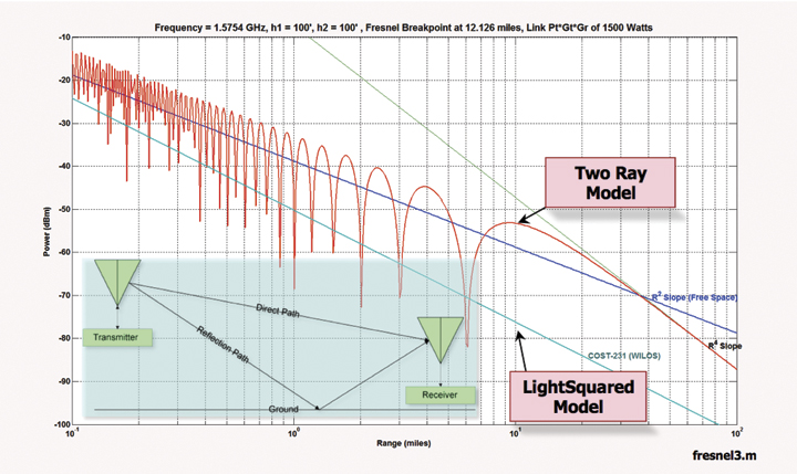
    Günther Hein of the European Space Agency shows this remarkable diagram (Figure 1): as the number of systems increases and the number of satellites heads for that 150, up rises the noise they make, the blue-green line. More than about 70 of them, and satellite noise exceeds the cosmic noise floor in red and becomes the main source of noise. The more satellites, the worse the reception as GNSS interferes with itself. Too many satellites, and you’d pick up none at all! The first threat of the triple whammy is self-inflicted.

    Chart: David Last and Sally Basker
    Chart: David Last and Sally Basker

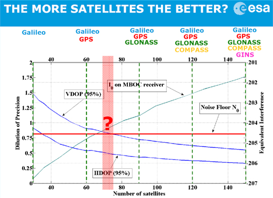
    Figure 1. The first threat of the Triple Whammy: new satellite systems. Source: Günther Hein.

    The Second Threat

    Conflicts between nations as their new GNSSs compete for radio spectrum also threaten GNSS viability.

    The frequency bands available to satellite navigation are essentially L2, L5, and the principal one we use currently, L1. On L1, the European Galileo system and the Chinese Compass system occupy the same areas. Now, that’s very desirable if the two systems are to share receivers. But they also compete for that spectrum, and there is conflict between Compass and Galileo.

    This battle for spectrum is a highly complex engineering problem. But chiefly, the spectrum wars are political, even emotional.

    Chinese satellites fly across American skies broadcasting signals that interfere with European receivers. Spectrum wars have everything to do with relationships between nations and little to do with battles between engineers. They are developing into a classic tragedy of the commons: a situation in which self-interest determines how a limited resource — here the radio spectrum — is to be shared in a regime in which regulation is weak. The International Telecommunication Union sets standards and registers claims. The UN Office for Outer Space Affairs seeks to mediate. But neither is a policeman; sovereign governments may sometimes be penniless, but they are very powerful.

    The second threat of the Triple Whammy is also self-inflicted.

    The Third Threat

    Communications systems compete with GNSS for spectrum: witness the current LightSquared case of a powerful new broadband system. For existing receivers, including those in government systems and aviation, it seems there is no fix for its devastating interference. LightSquared is driven by rich and powerful commercial forces; it could well win this fight.

    Communication technologies will continue to press upon the satellite navigation spectrum. LightSquared will likely erode spectrum gaps between communications and navigation services, the so-called guard bands.

    Satellite navigation has become highly political. The intense use of GNSS across our economies makes them vulnerable. GNSS is threatened by a Triple Whammy, by jamming, and by spoofing. These increase the risks to our security and our economies, both in probability and impact. The solution of detecting jammers and making ownership illegal will help with local problems in local areas. But the Triple Whammy threats are not local; they are national and international, world-wide.

    Today’s spectrum wars affect us all. That the loss of GPS would increase the price of a loaf — the very trigger for the French Revolution — brings this down to earth.

    These are not technical issues, they determine the price of our food! They constitute a real and present danger to our societies — down to the mundane yet very real level of our daily bread.


    David Last is a past-president of the Royal Institute of Navigation, a consultant and expert witness on radio-navigation and communications systems to companies, governmental and international organizations, and criminal investigators.

    Sally Basker, former director of research and radionavigation at the General Lighthouse Authorities of the UK and Ireland, has opened Traxis Ltd: management, business, and technology advice with expertise in navigation service provision. See www.traxis.co.uk.


    This article is adapted from a presentation at the European Navigation Conference, London, November 2011. A longer version of the talk appears in the Royal institute of Navigation News.

  • Interview: 2nd Space Operations Squadron Commander, Lt. Col. Jennifer Grant

    December is typically the month when writers of regularly featured columns wax nostalgic and engage in a certain amount of prognostication. This year I enlisted the help of Lt. Col. Jennifer Grant, the 2SOPS/CC at Schriever AFB, the home of GPS, to help us with our year-end review and crystal-ball gazing as we look ahead to the GPS horizon. Lt. Col. Grant reminisces about her first 16 months as 2SOPS/CC, reviews numerous major accomplishments, and updates us on the status of the GPS constellation as well as the often overlooked, ever contentious and always seemingly in flux critical Command and Control (C2) segment.


    By way of introduction, I first met Lt. Col. Grant when she was assigned to the Command Suite at Headquarters Air Force Space Command at Peterson AFB in Colorado Springs, Colorado, and served under the four-star commander General Robert Kehler, who is now the commander of USSTRATCOM (United States Strategic Command). At the time she impressed me as being intelligent and insightful. Her professional reputation as a perfectionist certainly supported that assessment. The next time I met Jennifer, we were both wearing different hats and serving in different roles.

    Several of us on the GPS Independent Review Team (GPS-IRT) were sent by General Kehler to Schriever AFB to check in with the new 2SOPS/CC and see if we could offer her any assistance. This is a role we, the IRT, have played many times in the past, and just like the old saw concerning Inspector General (IG) visits, our mantra was and is “…we are only here to help…that’s our story and we are sticking to it.” Regardless of the perception or even trepidation over our visit, Jennifer and her staff were extremely supportive and it was abundantly clear that Lt. Col. Grant was drinking from a fire hose and doing more than surviving. She actually seemed to be handling it well and possibly even enjoying herself. While she was not new to Space Command, she was new to the GPS.

    More than a year later, I and another IRT member paid Lt. Col. Grant another official visit and the transformation was nothing short of amazing. Did I fail to mention that she is also known as a quick study? In 16 months’ time Jennifer went from the new kid on the block in GPS operations to a sophisticated, erudite, extremely knowledgeable and passionate advocate and supporter of the GPS and all aspects of 2SOPS operations.

    Recently she stood toe-to-toe in a meeting with the same GPS-IRT members that visited her 16 months ago and proved without a doubt that she has matured as a commander and GPS operator beyond our wildest imaginations. To her credit she is not intimidated by titles, rank or history. She knows her job. She walks the talk and will not hesitate to challenge anyone, although very politely and with a smile, who is not totally accurate and fair in his or her assessment of GPS operations yesterday, today and tomorrow.

    Like any good commander, she is totally and relentlessly supportive of her command and her people. However, she is pragmatic enough to know that changes, and big ones, are on the horizon. At the same time she realizes that she commands not only the largest and most well-known military space constellation on orbit today, but also one that supports the entire planet’s critical infrastructures with crucial timing, frequency, position and navigation information. GPS has become the de facto time and time frequency distribution system for the world we live in today. There are more than two billion known users worldwide, and that conservatively equates to more than 5 billion GPS receivers. Indeed, given the number of stealth GPS receivers in almost every appliance we use today, that number could easily grow to more than 10 billion. No stress there!

    When I called Lt. Col. Grant about a follow-up IRT visit and mentioned that an interview might also be in order, she replied that she would get right on that as soon as she spent Thanksgiving with her family. Imagine that, she actually took a day off. In the real world she seems to balance being a wife, mother and commander of the world’s most visible satellite constellation with a maturity beyond her years.

    Now that we have peeled back the curtain just a bit, let’s see what Lt. Col. Jennifer Grant has to say about the Global Positioning System and PNT in general.


    DJ: Don Jewell, GPS World Defense Editor
    JG: Lt. Col. Jennifer Grant, 2SOPS Commander 


    DJ: What can you tell us about your first year as the 2SOPS/CC?  What makes you happy about your command job and GPS specifically?

    JG: Don, my time as the new 2SOPS/CC has really passed quickly! Commanding the largest DoD satellite constellation is both humbling and invigorating. It is amazing to look back over the past year and recount our accomplishments as a team: I accepted satellite control authority of the first two GPS IIF satellites; we completed the largest satellite repositioning in history with expandable-24; we successfully completed two major test exercises involving demonstrations of flex power and SA/ASM (Selective Availability and Anti-Spoofing Module), respectfully; we successfully completed the largest major software sustainment installation, AEP 5.7.0 [ed. Architecture Evolution Plan]; we flawlessly executed two operation mission transfers to our back-up (Command & Control) location; we’ve completed dozens of station-keeping maneuvers; we’ve resolved on-orbit anomalies and sustained the constellation of satellites which have outlived their estimated design life — and celebrated the 21st birthday of SVN-23, our oldest IIA satellite on orbit. We’ve also disposed of SVN-24 and are preparing for the disposal of SVN-30. Our GPS Operations Center (GPSOC) has provided 75,000+ products to our mission planners and warfighters down range, and we have seen the implementation of our GPS Google Earth tool.

    On the personnel front, we were part of the team, along with 19SOPS and SMC — Space and Missile Systems Center, awarded the USAF Chief of Staff Team Excellence Award (CSTEA) in Washington, D.C., for the GPS IIF Launch; and we were part of the past and present GPS team of personnel earning the International Aerospace Federation’s 60th Anniversary Award for excellence in aerospace. General Shelton accepted this award in Johannesburg, South Africa, on behalf of the U.S. Air Force contributions to the GPS. We have also achieved the most accurate signal-in-space in our history, far surpassing the office of the Secretary of Defense, Standard Positioning Service Performance Standard requirement of seven meters!

    2SOPS, with assistance from our reserve mission partner, 19SOPS, supports more than two billion position, navigation and timing (PNT) users worldwide. The work we do every day and the mission we execute supports critical infrastructure, life-saving missions and worldwide operations.

    100820-F-1631A-028 . Headshot: Lt. Col. Jennifer Grant
    Lt. Col. Grant speaks at the change of command ceremony in August 2010,
    when she took over command of 2SOPS.

    In short, Don, I love my job — and I have the sharpest, best and brightest team of personnel employed to execute these tasks. I am amazed every day at the level of proficiency and professionalism demonstrated by our Total Force team of active duty, reservists, aerospace engineers, contractors and government personnel. Our team has managed and maintained the position, navigation and timing gold standard and will continue to do so.

    Making a difference in the lives of people gives me a great deal of personal and professional satisfaction. We are not doing our jobs right if we are not making the world a better place…one contact at a time, be it people or payloads.

    DJ: Can you give us a status of GPS as a system of systems, to include ground control, monitoring and the on-orbit constellation? Give us, if you will, a status brief of where GPS stands today, including SVN-49. And, since you are known for being precise when you speak about GPS matters, can you please answer using the nomenclature we should all use when we refer to the various segments of the GPS?

    JG: Absolutely, Don! The GPS constellation is the most robust and capable system in the history of space.  We currently have 30 actively engaged operational satellites on orbit (9 GPS IIAs, 12 GPS IIRs, 7 GPS IIR-Ms and 2 GPS IIFs). We maintain a program baseline minimum 24-satellite constellation consisting of six orbital planes each containing four primary satellite slots. Our four dedicated ground antennas and six monitoring stations are working as intended, and our MCS (Master Control Station) at Schriever AFB as well as our AMCS (Alternate Master Control Station) at Vandenberg AFB are both fully functional.

    On 15 June 2011, we completed expansion of a total of three primary slots, which added 3 satellites into our current baseline and enables us to optimize GPS assets to improve operational effectiveness for global users and warfighters in terrain-challenged areas.

    Currently, there are 30 satellites set healthy to users, and a 31st satellite, a GPS IIA, will be set healthy on 16 December 2011. We have one satellite awaiting disposal and three remaining satellites in residual status. Each of the three remaining residual satellites are in LADO, which is our unique Launch/Early Orbit, Anomaly Resolution, Disposal, and Operations system. One of the residual satellites is SVN-49, and they will all be tested and checked out for determination of future use and viability as a long-term operational decision.

    DJ: Those of us who have been Squadron Commanders know there are persistent problems in any organization that just won’t go away, be they programmatic, operational or personnel issues. What is it that keeps you up at night?

    JG: Thankfully, Don, I am a sound sleeper with peace of mind, so not much!  But really, one of the main responsibilities we manage is maintenance and sustainment of the GPS constellation, and the older the satellites in the constellation get, the more care and feeding they require. Right now, about a third of our constellation has exceeded its satellite design life by 100% — satellites designed to last 7.5 years are between 15 and 21 years old. So we have invested a great deal of time into contingency planning in the event of component failures, multiple vehicle anomalies, etc. We are doing everything we can to continue to extend the lives of our satellites, and it is a tribute to engineering, design and the satellite builders as well as the expert sustainment operations and engineering that they have lasted as long as they have.

    We need to ensure our replenishment launches for the current generation IIF vehicles stay on schedule and a priority.

    DJ: Would you give us your view and hopefully the MAJCOMs view of the way ahead for GPS as it supports military, civil and commercial users around the globe? Look forward to the future for us — how do you see GPS operations evolving in the years ahead?

    JG: Don, the Air Force is constantly being asked to do more with less — resources, manpower and time.  In this fiscally constrained environment we are being challenged to find effective and efficient ways to accomplish our mission. We have come a long way from the legacy systems in improving our operations, and I think we will see even more improvements in increased automation, faster satellite contact times, and increased downlink capabilities, as well as streamlined operations.

    We will also, I believe, see an increased need for interaction and interoperability with our international position, navigation and timing providers and consumers. GPS, though still the largest PNT provider, is no longer the only game in town.

    Although the GPS satellite constellation is procured and operated by the US Air Force, we understand we support a much broader user community in the civil, commercial and military sectors. We take pride in providing extremely accurate PNT services to billions of users worldwide.

    And we are spending considerable resources to modernize the GPS constellation to provide even better service in the future. The continued fielding of new GPS IIF satellites and GPS control segment software updates are key to current modernization efforts. GPS III satellites and the Next Generation Control System (OCX) will further enhance GPS capabilities. Fully compliant user equipment is essential as modernization efforts continue.

    We’ll continue to improve our constellation with the launches of new satellites; the next GPS IIF is scheduled to launch in September of 2012 and the first GPS III should be available for launch in FY 2014. And OCX remains on-track for a Ready-To-Operate (RTO) date in 2015.

    DJ: And finally, if you were Queen for a Day, what would you like to see changed?

    JG: For operators, there is always an interest in and a desire for greater capability, faster processing…and for us it is in pushing the envelope for even greater accuracy with precision timing, position and navigation.

    There is also an interest in expanding application of our NAVWAR (Navigation Warfare) knowledge, application and operations — having an even greater number of people trained and embedded with warfighters as NAVWAR experts. This is where I think we will see some real growth in the future.

    DJ: Colonel Grant, I know you are incredibly busy and I can’t thank you enough for your time, your expertise and the look ahead to the future of GPS. Best of luck in all your future endeavors.


    Editor’s Note: I have visited the 2SOPS more than 20 times in the past five years, and I have known and visited every 2SOPS commander since that organization began to include then Lt. Col. and now General William Shelton, the four-star AFSPC/CC. I have never seen a more motivated GPS crew force than the one I saw during my last visit with Lt. Col. Grant. Squadrons tend to reflect the work ethic, mores and integrity of their commander, and my hat is off to Lt. Col. Jennifer Grant because her crews are obviously very motivated to support the warfighter, and they seem very happy in their jobs. The atmosphere in 2SOPS these days is positive, upbeat and very customer (that’s you and me) oriented. Plus, many of the crewmembers are just back from tours in Afghanistan and Iraq, so they know the needs of the warfighter and they are working hard to fulfill them.
    Till next time, happy holidays and happy navigating.

  • Expert Advice: Test-Based Civil Receiver Certification

    Logan Scott
    Headshot: Logan Scott

    By Logan Scott

    Disaster-preparedness plans recognize the individual’s role in his or her own survival. When storms approach, have water, food, and basic survival gear on hand. It takes time for help to arrive.

    The civil GPS industry faces an oncoming storm of interference, and the receiver is the first line of defense. As we integrate GPS into all facets of our lives and infrastructure, we become more subject to disruptions, both unintentional and intentional. Newark International Airport now sees several jamming events per day. In Taiwan, one airport experiences an average of 117 events per day!

    How can civil PNT infrastructure be made more resilient?

    Faced with jamming, spoofing, and cyber attacks, receivers must take basic precautionary measures. They must recognize jamming and spoofing attacks to avoid generating hazardously misleading outputs. Situational awareness is key. Accurate and specific alarms must be generated so users can take action and authorities can be notified. Regular threat-signature updates can improve situational awareness, much like antivirus updates on a computer. Fire alarms don’t put out fires but they do save lives and improve response time.

    Twenty years ago, computers rarely had firewall or antivirus protection. As GPS becomes more deeply integrated into communications-enabled systems, its utility increases exponentially but so does its vulnerability to cyber attack. When you update your GPS software or your maps, how do you know they have not been compromised? How do you know your receiver is authentic?

    slide15
    Figure 1. There are demonstrated, well known attacks that can cause receivers to output misleading information without warning. Many of these attacks can be detected using simple methods. Some receivers incorporate detection and countermeasures techniques. Many don’t. Receiver certification provides GPS buyers with a starting point for selecting GPS receivers. Certified receivers can accurately report on interference so it can be located and stopped.

    The U.S. Navy recently discovered counterfeit routers in several of their installations. Well-developed computer security methods such as the Trusted Platform Module found in more than 300 million computers can help secure GPS receivers without impeding innovation.

    The government can also play a role in improving receivers by providing an authenticatable civil signal structure. Well-documented Public Key Infrastructure methods such as digital signing and occasional, short-spread spectrum security-code bursts can be added to the new L1C signal. Receivers voluntarily using these signal features can establish signal provenance with extremely high confidence.

    The public, unclassified keys needed to process these features could be sold and used as a revenue source for the GPS system. Receivers that choose not to use these features can ignore them without adverse impact other than weaker security. The large numbers of in-theater military users who rely on civil signals would also stand to benefit.

    Finally, I would note that situationally aware receivers can provide specific and detailed reports about what they see. Interference-monitoring systems such as Patriot Watch will need detailed reports to sort and associate the multitude of reports they receive into a coherent picture of what is actually happening. To provide adequate geographic coverage, interference monitoring systems will need to accept reports from diverse receiver types on an opportunistic basis. In short, they will have to rely on crowdsourcing as a major operational input.

    As Brad Parkinson noted during my presentation of this material to the November 9 meeting of the National PNT Executive Committee Advisory Board (“Receiver Certification: Making the GNSS Environment Hostile to Jammers and Spoofers,” at www.pnt.gov/advisory/2011/11/), in the early days of electricity, a lot of houses burned down because of electrical problems. Underwriters Laboratories helped immensely by testing electrical equipment to make sure it was reasonably safe, and consumers looked for the UL label. A voluntary, basic receiver certification process similar to Underwriters Laboratories should be pursued to provide the user community with a basis for selecting receivers.


    Logan Scott has more than 32 years of military and civil GPS systems engineering experience. At Texas Instruments, he pioneered approaches for building high-performance, jamming-resistant digital receivers. While at Omnipoint, a cellular carrier, he developed cross-system interference mitigation strategies. He holds 33 U.S. patents.

  • Expert Advice: MSS Misinformation, and Ten Truths

    By Rich Keegan

    LightSquared is currently conducting a public campaign intended to persuade federal regulators to approve a nationwide broadband service that would be detrimental to users and applications that depend on GPS. The campaign relies on misinformation, revisionist history, half-truths, and clear misstatements of fact. To understand the effort to convince regulators and legislators that the experts are wrong, one must consider 10 basic truths.

    1: The MSS Band Was Not Meant for High-Powered Terrestrial Use. The FCC authorized use of ancillary terrestrial component (ATC) ground transmitters many years ago within the mobile satellite services (MSS) band. The LightSquared campaign claims that this proves the band was intended for primary high-powered terrestrial use. But note ATC means ancillary terrestrial component, not primary. The FCC allowed this use only to fill in small holes in coverage from satellites. The term MSS recognizes that the band was for use by low-powered satellites, not high-powered land transmitters.

    The FCC conditional waiver given to LightSquared, if allowed to stand, would completely change the nature of the band, converting it to primary terrestrial use by 40,000 or more high-powered ground transmitters. Many FCC statements preceding the conditional waiver make it clear that the LightSquared effort is precisely what the FCC said would not be permitted.

    2: Interference to GPS Has Not Been Resolved. LightSquared assured the GPS community when the conditional waiver was announced that all interference issues had been addressed, and its system would not interfere with GPS. It was immediately clear to GPS engineers that this was wrong, and subsequent testing ordered by the FCC, along with that done by manufacturers, federal agencies, and independent organizations, confirmed that the original LightSquared system would cause massive interference with all classes of GPS receivers.

    Faced with irrefutable evidence of massive interference, LightSquared revised its system design to propose initial use of only 10 MHz of spectrum farthest from the GPS band (Low 10) for an unspecified period of time, after which it would be allowed to add the closer 10 MHz (High 10). While it may be feasible in the future to develop GPS receivers that could tolerate Low 10, several things are reasonably clear:

    • High-precision receivers that can tolerate High 10 and work as well as the ones we now use can’t be built, now or in the foreseeable future. LightSquared’s claims that “we can innovate our way out of this” are wrong with respect to High 10. Filters that LightSquared presently touts to allow Low 10 would not work in the High 10 environment.
    • Based on limited testing and analysis, Low 10 causes less interference than the original plan of Low 10+High 10, but the Low 10 effects on many receivers, particularly high-precision receivers in many high-value applications, remains substantial.

    With this plan, LightSquared claims that 99 percent of existing GPS receivers would not suffer harmful interference. This conclusion relies on a definition of harmful interference of C/N0 degradation of 6 dB for general navigation devices (the GPS industry and FCC precedent require only 1 dB), and on testing cell-phone GPS with a simple pass/fail criterion, ignoring performance degradation and the fact that modern cell phones are much more like general navigation devices and PNDs than older cell phones. Slanted and unorthodox analytical parameters produced this rosy assessment.

    Based on evidence of Low-10 interference, the NTIA and FCC ordered more testing specifically focused on Low 10. In response to mounting evidence of interference at this level also, LightSquared has now offered a third version of its system architecture, using Low 10 and limiting power on the ground. From a GPS interference perspective, this power reduction is useful. However, the latest LightSquared plan does not fully address three key problems:

    • There has been no renunciation of High 10. LightSquared says that in 5–6 years it will need spectrum capacity beyond Low 10. It would be irrational to design receivers now that tolerated Low 10, only to find in a few years that the requirements had changed to require tolerance to High 10 also (which is not possible).
    • There will still be interference with GPS receivers of various important classes in the power-limited environment of the latest plan.
    • None of the evolving plans deals with the massive installed base of GPS receivers.

    3: The GPS Industry Did Not Know of a Spectrum Conversion. LightSquared claims that for many years GPS manufacturers were aware of the proposed ground transmitters and should have designed receivers to avoid picking up strong signals in this neighboring band. These claims of foreknowledge of a recent fundamental change in proposed use of the MSS band are fallacious.

    The U.S. GPS Industry Council at the time of the limited conditional approval of ATC transmitters (circa 2003) consisted of only two or three GPS manufacturers. It is clear from USGIC statements at the time that it did not anticipate a spectrum reallocation. In any case, it is a huge stretch to claim that USGIC represented all GPS manufacturers, let alone the entire GPS industry and users. The GPS industry had no indication that the FCC would ever radically reallocate MSS band for a stand-alone high-powered terrestrial network, prior to November 2010.

    As [GPS World survey editor] Eric Gakstatter has pointed out, a major change with the potential to affect all GPS users should follow certain guidelines. The Air Force GPS Directorate demonstrated this in handling a much less important change to GPS signals: discontinuing support for the semi-codeless technique used in most high-performance receivers. In 2008, it hired consultants to question all manufacturers and many users of GPS about the potential impact. It then proposed that the signal change would occur on December 31, 2020, giving more than 12 years to prepare for the change.

    Should we ask anything less from LightSquared’s far more radical proposal?

    The FCC has a process that would have been much more appropriate for a proposal to reallocate the MSS L-band to high-powered terrestrial use: Notice of Proposed Rulemaking. Had it followed this process, we might be having a productive discussion of technical aspects.

    4: GPS Receivers Properly Use the MSS L-Band. LightSquared asserts that GPS receivers intrude into LightSquared’s spectrum— a misleading claim. Many GPS receivers in fact have filters that do not block signals from the MSS band. There are several reasons for this:

    • So long as the MSS band was a satellite band for signals from space to Earth, the signals from other systems in that band were low-power and not harmful to GPS reception. GPS receiver designers relied on this and assumed this allocation of the band would continue. The ability to use filters that overlap into the MSS band has enabled both low-cost and high-precision GPS receivers.
    • High-precision receivers cannot produce accurate measurements without using wideband GPS signals that occupy most or all of the GPS band. “Brick wall” filters that could capture all the energy in the GPS band and none of the energy in the adjacent MSS band do not exist.
    • Lightsquared ignores hundreds of thousands of high-accuracy, high-value GPS receivers that receive signals from the MSS band, using it for its intended purpose — satellite to ground communication. Deere receivers use the StarFire system leasing use of transmitters on MSS band Inmarsat satellites. Trimble leases use of MSS band on LightSquared’s own satellites for OmniSTAR correction signals.
    • GNSSs worldwide are modernizing their signals; many of these new signals are wideband. To take advantage of them, modern receivers of all classes will be wideband, as high-precision receivers are now, and will suffer interference similar to that of high-precision receivers now.

    5: GPS Receivers Do Not Ignore Government Design Standards. LightSquared asserts that the fundamental GPS L1 signal specification mandates receiver design standards that the GPS industry has ignored, to save a few cents of cost. These claims are false. The GPS specification defines the signal-in-space and explicitly says that it is not a receiver design standard; it simply uses a nominal receiver design to be able to translate signal-in-space specification into navigation performance effects.

    6: Receiver Replacement Costs and Schedules Are Large. LightSquared has offered $50 million to fund retrofit or replacement of legacy government receivers impacted by its signals. General Shelton of the Air Force Space Command testified to Congress that it would take billions of dollars to replace or retrofit the government receivers. He also estimated a 10-year time frame to test and validate replacement receivers.

    LightSquared says it will not bear the costs of replacing commercial receivers since, it claims, manufacturers are responsible for the improper design of those receivers. This is wrong, as shown earlier. LightSquared should bear the cost of replacing commercial receivers, if allowed to proceed. A realistic time frame needed to replace high-accuracy, high-value commercial receivers is also about 10 years.

    LightSquared argues that in five years, most current GPS receivers will be obsolete. This is clearly not true. Many current high-precision receivers are already prepared to use modernized signals from GNSS constellations. The L1C GPS civil signal, for instance, will not be available on any satellite until 2014, and the full constellation of satellites with L1C will not be available until 2026. Therefore, many receivers in use now will continue to be in use for many more years than five.

    7: Other GNSS Are Also Affected. Because Galileo, Compass, and GLONASS use or will use signals similar to GPS, in the same band as GPS, they will suffer interference very similar to that suffered by GPS. Users will lose the benefits of these other constellations, as well as GPS.
    The United States has entered into formal obligations to protect some other GNSS signals; LightSquared signals are not compatible with these U.S. obligations.

    8: Handset Interference is a Serious Concern. LightSquared handsets do not yet exist, but testing to date makes it clear that the handset signals to communicate with LightSquared base stations also interfere with GPS receivers when they are nearby (a few meters). The interference to GLONASS reception is also likely to be harmful. The interference effects of a group of LightSquared handsets has not been fully evaluated, but will certainly create more interference for nearby receivers.

    Out-of-band emissions from LightSquared handsets, if as high as FCC power masks currently permit, would substantially interfere with all GPS receivers, possibly more than LightSquared base stations.

    9: The Solution Is Not a $6 Filter. LightSquared displayed a Deere high-precision receiver with a “$6 filter” and told Congress this proved it could be done inexpensively and quickly. The claim is based on half-truths.

    • The Low 10 signal can be filtered out using low-cost parts, but the effect on performance is not known. There is good technical reason to be concerned about degraded performance from this filtering.
    • The Deere receiver displayed is not capable of readily being retrofitted with LightSquared’s or any other filter. Like many high-precision units, it is an integrated, hermetically sealed device. Retrofitting would entail returning the unit to the factory, cutting open and discarding the case, replacing the antenna/preamp assembly with a redesigned antenna/preamp assembly, inserting the unit into a new case and sealing it, re-testing the unit, and returning it to the customer. A costly process.
    • Filtering is one element of a design, usually distributed across several stages of the receiver. Changing filtering requires a redesign that may stretch across the entire RF front end, and cannot be done casually.
    • The displayed filter’s specified insertion loss is 3 dB, well above what GPS designers normally accept, and would result in about 2 dB more loss of sensitivity than with current filters.
    • LightSquared has suggested moving StarFire and OmniSTAR augmentation signals to the top of the MSS band, very close to the GPS band, so that filters that included GPS could include them. This is a reasonable approach, but the “$6 filter” might not permit that, as it would excessively attenuate at least the StarFire signal.

    10: The GPS Industry Supports National Broadband. The GPS industry broadly supports the goal of extensive and pervasive national broadband, and of strong competition among providers. Pervasive broadband would be helpful for applications such as real-time kinematic (RTK) positioning. It would be beneficial to GNSS users to have broadband services available everywhere, but not if the cost is to degrade or deny GNSS service.

    LightSquared’s broadband services require terrestrial base stations and cannot be done with the LightSquared satellites. It is unlikely that low-population areas will be covered with terrestrial base stations due to the economics involved, but if broadband coverage is nationwide, then so too will be GPS interference.


    Rich Keegan is a senior principal engineer at NavCom Technology, Inc., a wholly owned subsidiary of Deere and Company.

  • Expert Advice: Realizing Europe’s SatNav Ambitions

    Exp-Adv-NovBy Axelle Pomies and Gard Ueland

    The 21st century today faces and will continue to encounter many new societal challenges, all mutually interdependent: health, environment, agriculture, ageing population, personal security, public and civil protection, safe and efficient transport and mobility, citizen rescue, land management, energy (supply, security, and efficiency), full employment, new consumer services, high-tech industry, business security, connectivity, globalization, intellectual property management and protection.

    All these challenges have a common denominator: the economic health of Europe: growth, competitiveness, and job creation. Along these lines, the European Union (EU) created the Europe 2020 strategy for smart, sustainable, and inclusive growth. Its goal is to achieve growth by “developing an economy based on knowledge and innovation, promoting a more resource-efficient, greener, and more competitive economy, fostering a high-employment economy delivering social and territorial cohesion.”

    The role of European institutions in the growth process is especially decisive at a time when all organizations struggle to borrow, spend, and invest in the current economic situation. The need to stimulate the economy and to ensure competitiveness and return on investment in Europe is more important than ever. Among the growth-enhancing items identified in the EU2020 strategy, research and development (R&D) and innovation are part of the top priorities: “3 percent of the EU’s gross domestic product (GDP) should be invested in R&D” is one of five top EU targets. The European Commission also put forward the Innovation Union concept initiative “to improve framework conditions and access to finance for research and innovation so as to ensure that innovative ideas can be turned into products and services that create growth and jobs.”

    Given EU budgetary restrictions, as stated in the EU2020 strategy, the financial framework must be “devised to maximize impact, ensure efficiency, and EU value-added.” This is why the EU budget must be carefully invested in research and innovation areas that both have strong growth potential and satisfy Europe’s political, societal, and economic interests.

    The domain of satellite navigation applications, rapidly becoming a pillar of 21st-century society, offers a splendid opportunity among the most promising ones!

    Key GNSS Applications

    • Transport. Increased safety and efficiency for aviation, maritime and inland waterways, rail, road transport, and more.
    • Environmental protection. Support to environmental driving, car parking, waste control, low-cost sensors for landscape monitoring, resource monitoring. and land administration through surveying and mapping…
    • Health. Tracking and tracing of medical goods, assistance to elderly and disabled people.
    • Agriculture. Precision agriculture, livestock management…
    • Mobility. Navigation, road tolling and charging, location-based services, multi-modal transport services…
    • Security and Safety. Pay-as-you-drive insurance, law enforcement, protection of intellectual property rights, secure asset and personal tracking, unmanned vehicles, integration of GNSS, satellite communications, and global monitoring for environment and security, customs and freight monitoring…
    • Timing and Networks. Synchronization of smart grids, telecommunications, banking, and digital video broadcast networks…

    Public Funding Requirement

    EU public funding is necessary for Europe to attain excellence, compete in a global market, and expect future commercial and societal benefits.

    GNSS positioning, navigation, and timing technology is fast becoming a mature commodity, but major improvements are still required. Without EU public support, such as the Framework Programs for R&D, GNSS development will continue to follow a purely economic approach from industry, that is, maximizing return on investment rather than seeking to innovate technology. Industries will naturally look to combine commercial off-the-shelf sensors and functions, with minimal effort on R&D, rather than improving GNSS technology’s ability to meet evolving needs.

    This approach jeopardizes both European excellence in the GNSS field and the future take-up of European GNSS infrastructure.

    Foster Knowledge, Create Jobs. There is a compelling need to foster European knowledge and capability to reach excellence in the GNSS field, in order to maximize competitiveness, growth, and job creation in Europe. The purely commercial approach will continue to place the U.S. GPS as a standard; this constitutes a major risk for Galileo and for the EU economy as a whole, as it would continue to rely on a GNSS service over which it has no control.

    Therefore, EU public funding, through such initiatives as framework programs (FPs), competitiveness and innovation programs, and Horizon 2020, is essential to ensure the use of European infrastructures and the generation of benefits for Europe. This will give the means to the EU industry to get a better share of the global GNSS downstream market.

    It is a question of business, growth, employment, and return of EU investment in the European GNSS programs. As an example, most non-aviation applications of the European Geostationary Navigation Overlay Service (EGNOS) infrastructure exist solely from the stimulation of FP6 and FP7 projects.

    Finally, the cycle of EU public funding — which creates projects that link people not used to working together, to stimulate creativity and foster innovation — also must be underlined. Through these programs, small-to-medium enterprises (SMEs), large companies, academia, and research institutes from EU countries and beyond can meet and work together. To link people and brains and stimulate creativity is a perfect springboard for new ideas and market opportunities.

    We emphasize at this point the huge risk of the absence of FP7 GNSS applications R&D budget until 2014 — the dedicated FP7 budget being exhausted due to extensive cuts, leaving only ϵ100 million in the GNSS FP7 budget line, instead of the ϵ350 million granted at the outset. A lack of public support for R&D effort would significantly limit the potential of innovation and growth as well as European ambitions in GNSS.

    The European Parliament Resolution of June 7, 2011, on “Transport applications of Global Navigation Satellite Systems: Short- and Medium-term EU Policy” revives hope among European downstream research and innovation actors. Among other things, Parliament calls on the European Commission (EC) “to ensure that the ϵ100 million likely to be underspent in payment appropriation for research within the 7th FP is made available for the development of GNSS applications.”

    Applications a Promising Market

    GNSS-based positioning/timing technologies and services must be part of the long-term growth priorities of the European Union. As part of the solution to the next generation of challenges, GNSS technology can contribute significantly to all major EU policies.

    GNSS applications and services development can bring immediate benefits — creation of new industrial activities and hundreds of thousands of jobs — and enhance daily life and well-being of Europe’s citizens; the core vocation of GNSS applications is fully in line with the Lisbon Treaty.

    Further, GNSS applications and services constitute one of the most promising sectors for European growth. The global GNSS market amounted to around ϵ130 billion in 2010 and is expected to reach ϵ240 billion by 2020. This corresponds to a sustained growth rate of more than 11 percent per year.

    EU public funds invested in GNSS applications R&D would catalyze growth, enabling market development and maximizing the efficiency of EU budget. With only a small part of its budget dedicated to GNSS applications R&D, the EU would see both an important and decisive impact on the GNSS market and a snowball effect, seminating further applications and domains with GNSS technology.

    The 2010 FP7 budget for GNSS R&D was ϵ30.5 million. Assuming that EU27 member states made similar contributions at the national level and that two-thirds of GNSS R&D investments come from the private sector, the total EU investment in GNSS applications R&D totalled ϵ180 million in 2010.

    Since the EU GDP of GNSS applications and services amounted to around ϵ26 billion in 2010, the rate of GNSS GDP to investment in applications R&D’ corresponds to a factor more than 100. In other words, ϵ1 invested by in GNSS application R&D generates about ϵ100 of revenue.

    The Need for Dramatic Increase

    As stressed in the EU2020 strategy, “R&D spending in Europe is below 2 percent [of GDP], compared to 2.6 percent in the United States and 3.4 percent in Japan.” The Barcelona EU goals specify that R&D financing should be shared between public (one-third) and private sectors (two-thirds).
    In 2011, EU public investment in GNSS applications R&D is expected to be 0.1 percent of EU GNSS GDP — well below the required threshold. If the R&D budget is not restored, this rate will come very close to zero until 2014.

    In the Barcelona and Europe 2020 goals, the level of EU contribution to GNSS applications R&D investments can be computed (Figure 1). Ensuring EU benefits would require annual public support to GNSS applications research rising from ϵ100 million in 2011 to ϵ200 million in 2021.

    Schema_HD
    Figure 1. Minimum level of EU public funding required for GNSS applications R&D from 2011 to 2021.

    Increased investment would enable Europe to boost its current 20 percent market share to reach the 33 percent share that Europe enjoys in other high-tech sectors. This would mean creation of more than 400,000 new jobs in 2020.

    Contrary to the United States, China, and Russia, the EU lacks a large military applications R&D program, which elsewhere helps support industry investments in commercial and civil applications. Given European investments in other sectors and investment of other countries in GNSS application R&D, a level of EU public investment between ϵ100 million and ϵ200 million per year is essential.

    Horizon 2020

    Galileo Services makes the following recommendations for the EU program Horizon 2020.

    GNSS technologies and services.

    • Support European industry in investing and developing critical technologies, applications, and services based on end-user requirements: security, reliability, robustness, and high performance;
    • Pursue research to improve GNSS performance, mainly multi-constellation multi-sensor receivers;
    • Encourage innovative ideas, whatever the domain may be, through very open calls for proposals.

    Market penetration and development.

    • Adequate value-added content (such ashigh-precision or indoor digital maps) to leverage application development;
    • Market analyses and business cases, with a focus on new uses of GNSS;
    • Promotion and awareness activities;
    • Standardization in relevant domains;
    • A certification process for safety- and security-critical applications;
    • Demonstrations and pilot projects, focusing on implementation of GNSS solutions tightly integrated in the user workflow, involving all value chain actors;
    • Use of large European companies  — industry locomotives — and SMEs’ innovative capability to penetrate markets and spin off new business opportunities;
    • International cooperation established by: favoring EU industry interests within bilateral discussions between EU and non-EU countries, involving non-EU partners only if providing opportunities for market penetration beyond EU boundaries or specific skills and/or technology not available in Europe, and setting up adequate intellectual protection rights (IPR) policy.

    Other support.

    • Expectations of significant public-sector funding and regulations will stimulate private GNSS investment. Such tools are widely exploited in America, Russia, and Asia;
    • Regional and national procurement plans would benefit from coordination at the EU level;
    • A close dialogue has been established between European institutions and GNSS downstream industry, represented by Galileo Services, in recent years. In this framework, crucial issues such as licensing rules, IPR policy, and international cooperation can be discussed. This initiative must be pursued and even reinforced.

    Galileo Services is a non-profit organization founded in 2002 as a major partner for the Galileo program and GNSS application development. Although Galileo is a key area of interest for Galileo Services, the association focuses on all types of PNT systems such as GPS, GLONASS, Galileo, EGNOS, WAAS, and so on. Having merged with OREGIN (the Organization of European GNSS Industry of equipment and services) in 2009, Galileo Services network represents more than 180 member organizations from Europe, North America, and Asia, ranging from SMEs to large companies. Gard Ueland is president of Galileo Services, and Axelle Pomies is its permanent representative.

  • Expert Advice: EPIC Happening — Europe’s PNT Industry Council

    John_Wilde-W
    John Wilde

    By John Wilde

    We have the United States GPS Industry Council, the Japan GPS Council, and the Korean GNSS Technology Council.

    Anything missing?

    The challenges facing the performance, navigation, and timing (PNT) community, which relies on GNSS amongst other things, are getting more numerous and complex, and Europe is the only major territory without a unified industry nexus where such challenges can be engaged. However, this is about to change.

    From my background and current activity as CEO of DW International, an independent navigation consultancy with a strong interest in GNSS specifically, I have begun forming the European PNT Industry Council (EPIC) with other industry leaders to act as a focal point for the PNT community’s concerns and to help coordinate the effort for standardization and harmonization. Additionally, with issues such as the LightSquared debacle looming, it is key that European stakeholders have a voice on the global stage.

    A recent survey that the nascent EPIC conducted jointly with Marketing Analytics highlighted the need for an organization such as EPIC. We asked key PNT figures around the globe about the issues concerning them and how these concerns should be addressed by EPIC. For such a diverse group of respondents (including representatives from state transport agencies, academic institutions, OEMs, independent consultancies, land survey companies, maritime, and aviation) there was clear agreement on the need for a European focal point for PNT to better facilitate interoperability and harmonization of standards among the current PNT activities being undertaken around the world. Sixty-six percent of respondents wanted an international forum for information exchange (that is, ideas, best practices, and lessons learned) where such issues as interoperability and harmonization could be addressed.

    Sixty-three percent rated system-level PNT policy issues as a very important subject area for EPIC, while 56 percent rated standards for PNT in areas such as aviation, rail, and E112 as being very important. There is no shortage of issues to tackle, and EPIC will prove to be a key player in forming the coalitions required.

    As one respondent put it, when asked about his priorities regarding PNT policy:

    • Galileo launch schedule;
    • Compass CPII and CPIII signal details and operational plans;
    • Information about GLONASS L3 and GLONASS CDMA plans, particularly ICD and frequency of planned L1 CDMA signal;
    • SBAS plans, such as EGNOS and GAGAN;
    • European regulatory plans that relate to navigation and positioning; E112, road user charging, tracking and logistics;
    • Standards for navigation and positioning applications, plus applications that rely on a position.

    Whatever the appeal of a forum for the exchange of technical knowledge amongst professionals, it was also clear that respondents wanted EPIC to take action as well. One wrote:

    “EPIC needs to be outcome/results oriented and not turn into a talkfest. Therefore issues such as LightSquared need to be addressed head on so that bureaucrats start listening to the science behind decisions and policies rather than commercially driven for short-term political expediency.”

    Indeed, EPIC joined the chorus of organizations writing directly to the FCC calling for a rethink of the LightSquared issue.

    I personally believe that with the industry councils active in the United States and Asia, EPIC is the third leg of the stool. PNT is such a dynamic world, with so many moving parts, that even large international organizations risk being left behind unless their interests are represented and the information they need is available in a consistent and practical fashion.

    But more than that, PNT is a utility that needs to be protected, maintained, enhanced, and utilized. EPIC will ensure that those who want to, can.

    The need is there. The stakeholders are there. It’s happening.

  • Expert Advice: Exploring the Technologies Behind Location-Gate

    Feuerstein-200
    Marty Feuerstein

    By Marty Feuerstein

    For the past several months, controversy has raged over the revelation that Apple and Google tracked mobile subscriber location movements and stored that information in an unencrypted file on the handset, where it was potentially vulnerable to hacking and other inappropriate usage. The resulting Location-gate scandal highlights the sometimes tenuous control of mobile subscriber information versus the business objectives of dominant platform and applications providers. These business objectives may include immediate revenue opportunities from the subscriber being tracked or broader self-interest initiatives, such as collecting marketing data that may be valuable to third parties like advertisers, or building subscriber-reported Wi-Fi access point databases.

    Furthermore, while much has been written about the privacy impacts of the collection and use of consumer location information, few articles have clearly outlined the technologies behind Apple and Google’s tracking activities. It is important to fully explore and understand these technology methods, and how they differ from other location technologies in use, in order to properly evaluate the threat posed by Location-gate and to develop responses that maintain privacy while enabling the benefits of location-based services.

    Location, Tracking, and Storage

    iPhone and iPad subscribers had previously been aware that Apple tracked their location via GPS, because the company notified subscribers when an app required the use of GPS to identify location, and asked them to opt-in. However, soon after Location-gate erupted, Apple’s vice president of software technology, Bud Tribble, testified to Congress in May 2011 that Apple also had been tracking device locations over time using triangulation between nearby Wi-Fi access points and wireless base stations. Triangulation is the moderately accurate method in which the mobile device measures the nearby cell site or access point identifications and possibly signal strengths, typically pinpointing device location to within a few hundred meters.

    Following this revelation, Apple’s initial response was that “users are confused” and that it was simply “maintaining a database of Wi-Fi access points and cell towers around your current location…to help your iPhone rapidly and accurately calculate its location when requested.” Soon after Apple location tracking activity was revealed, it became known that Google was doing essentially the same thing, although to a slightly lesser degree (Android phones stored only the 50 most recent coordinate fixes and up to 200 Wi-Fi access-spot locations), and using a similar triangulation method without the subscriber’s explicit knowledge. Google Android devices also have GPS capability.

    Why, if both OS providers embedded or leveraged GPS in their phones, would they resort to a less accurate location method, triangulation?

    Neither company has provided an answer. We know that the triangulation method uses less battery power than GPS, conserving battery life for other uses while filling in performance holes for GPS in urban and indoor environments. Also, unlike with GPS, mobile subscribers are either not able to disable triangulation or must disable it separately. More relevant is the fact that triangulation allowed the OS providers to identify location automatically and track it over time in the background without the subscriber’s knowledge, for purposes such as building and maintaining a subscriber-reported database of Wi-Fi access points.

    From a privacy perspective, there is a dramatic difference between tracking someone’s location over time (the bread crumb trail that Apple and Google used), versus locating one’s position for a specific purpose and handling the location information only within the confines of a secure wireless network. Useful applications that are universally accepted, such as E911 for safety-of-life situations, employ the latter method.

    Other players in the mobile ecosystem, such as wireless network operators, have collected subscriber location information as well, but not by storing it in the device as historical files in the same way that Apple and Google did. Some information exists on the network side in association with billing records for calls (call detail records or CDRs), but this is not bread-crumb tracking of cell-IDs. E911 calls have records stored for use by public safety agencies, but most users never make an E911 call. Other messages containing coarse location may exist on a transitory basis (for example, location area updates), but these are not typically aggregated or stored for later processing.

    feurstein_figure-W
    Depictions of location information stored on handset and in operator network.

    Alternative Geo-Location Methods

    There exist location methods that provide far greater privacy and security than the location tracking and handset storage that Apple and Google have utilized. Standard methods exist for performing location using the wireless service provider’s network elements. These are called control-plane methods, which follow standards developed by 3rd Generation Partnership Project (3GPP) and 3GPP2. Other standard methods exist using IP transport from the client phone to a location server. These are called user-plane methods, such as the Secure User Plane Location (SUPL) standard from the Open Mobile Alliance (OMA). Both control- and user-plane location standards incorporate mechanisms for data security and user privacy. These standard control- and user-plane methods differ from the proprietary methods used by many client applications and OSs, which are inherently user-plane in nature but with non-standard implementations.

    Methods using a client application with handset-based location on the mobile device, also called user-plane methods, bypass the carrier’s wireless network elements and instead rely on an IP connection to transmit information from the client application to a server on the Internet. These user-plane location methods, such as client applications for handset-based A-GPS, as discussed, are already widely in use for location-based services. Handset applications are inherently vulnerable to hacking and privacy intrusions, as the recent spate of mobile viruses on Android has highlighted.

    A-GPS is highly accurate at identifying location in direct line-of-sight conditions with the satellites (open sky conditions), as found in suburban and rural areas, but performs less well in challenging dense urban and indoor environments. GPS in the phone can be easily disabled by the end user, and the receiver chip in the handset can cause significant battery consumption when used in demanding applications, such as navigation and monitoring geo-fences. A-GPS, as used by wireless network operators for navigation and other location-based services, does not usually store unencrypted files of historical location information in the handset, as Apple and Google did.

    Alternative, network-based, or control-plane, methods make use of the wireless services provider’s network elements to keep location information wholly behind the security of the operator’s firewall, employing highly standard protocols for security and privacy. Control plane location methods are used for today’s safety-of-life applications, like E911, where security and privacy are prime considerations.

    One example of a network-based location technology that can work in control-plane is RF pattern-matching (RFPM), which is the only high accuracy, software-based, scalable location solution that requires no additional hardware changes/additions to the mobile device or at the base stations. It compares mobile measurements (signal strengths, signal-to-interference ratios, time delays, and so on) against a geo-referenced database of the mobile operator’s radio environment. RFPM boasts a 100 percent security record for subscriber mobile location information it produces, for critical applications such as E911 emergency call and law enforcement location applications.

    Location information for growing consumer uses deserves the same privacy and security protections that other standards-compliant control-plane solutions provide for today’s mission-critical and safety-of-life location applications. RFPM works extremely well in non line-of-sight conditions such as dense urban and indoor environments, where GPS-based solutions face challenges. RFPM also offers low battery consumption and geo-fencing capabilities, which makes it ideal for providing location for the growing opportunity in location-based advertising and other location-based services (widely believed to be the true driver behind Apple and Google’s location tracking activities).

    As Location-gate clearly illustrates, there is no shortage of methods to identify and track one’s location via mobile device. Now that the issue has been raised, it is imperative that the entire mobile ecosystem — network operators, OS providers, regulators, and subscribers — clearly understand what methods are used, when one’s location is being identified and tracked, and what is being done with that data. Breadcrumb trails are useful if you’re trying to find your way out of the forest, but not if Big Brother is tracking you.


    Marty Feuerstein is chief technology officer of Polaris Wireless, where he leads research into new products, algorithms, system performance, and regulatory activities. He has a Ph.D. in electrical engineering from Virginia Tech.

  • Expert Advice: Cloud-Based Location Changes Enterprise Playing Field

    Mario Proietti
    Mario Proietti

    By Mario Proietti

    New technology and wireless carrier openness now make real-time access to telephone location information available to the enterprise with no application required on the mobile device.

    Yes, that’s right: no application required! Cloud-based location, offered via direct connections to wireless operators, changes the playing field for enterprises to introduce instant operational efficiencies. Marrying location insight, privacy controls, and multi-modal communications through network application programming interfaces (APIs) provides enterprises with flexibility, cost savings, and time-to-market advantages. Whether delivering geo-targeted promotions, dispatching services, verifying worker activities, or performing other location-relevant actions, businesses now have cross-carrier access to location information for more than 85 percent of U.S. wireless subscribers — instantly!

    This enables businesses to go app-less with no costly, time-consuming deployment and maintenance of handset applications. Additionally, no specialized hardware is required. Location through carrier networks also assures secure and tamper-proof delivery of the location information since no potentially hackable client software is involved in the generation or delivery of that information. It comes straight from the carrier network over secure connections.

    Cloud-based deployment, such as that available through TechnoCom’s Location Platform, opens up location intelligence to all device types, including both smartphones and feature phones. This removes a huge barrier that exists with the existing smartphone-only applications and enables businesses to immediately tailor their workflows and business processes to utilize the knowledge of real-time location from a secure and dependable source. Development cycles and costs are a fraction of those required for smartphone applications, such as Droid or iPhone apps, and the adoption hurdle of user download initiation is eliminated.

    Simplification of access and deployment paves the way for adoption and finally opens the floodgate for location-based services to be implemented on a large scale across all wireless networks. This is analogous to the inflection point that cross-carrier text messaging access and interoperability had on cellular text messaging adoption rates in the ’90s.

    By leveraging technology similar to that in the carrier networks and proven for use in 911 emergencies, businesses instantaneously benefit when new data is exposed by wireless operators, such as device capabilities, presence, rate plan status, roaming status, and so on. Enterprises may immediately harness this insight with upgrades to their server applications and no new technology deployments required in the field. That offers businesses a huge return on investment as they integrate once and consume enhancements dynamically. Location from the cloud opens up a new, instant intelligence frontier that was not possible for businesses to leverage just last year.

    This unprecedented access to location information comes with a responsibility to comply with industry-accepted privacy controls. To make this easy on enterprises that are not expert in such policies, TechnoCom Location Platform provides carrier-approved privacy management functionality, and we work hand-in-hand with our customers to ensure their implementations are in line with best practices established by CTIA.

    Tapping into location from other mediums such as VoIP, Wi-Max, NFC, Wi-Fi will increase the ubiquity of cloud-based location access even further. As devices get smarter and more powerful, better communications, device intelligence, and positional awareness will catapult businesses to yet another level of efficiencies in interacting with their mobile users, workers, and assets.


    Mario Proietti is co-founder and chief executive officer of TechnoCom Corporation, and a member of the Editorial Advisory Board of GPS World magazine. He has a master’s degree in electrical engineering from the University of Southern California. TechnoCom delivers cross-carrier location services to enterprises through its location platform’s web services APIs. The company also integrates location technologies into wireless networks, products, and software, and works with wireless carriers to enable E911 and location-based services.

  • Expert Advice: Who Won?

    Logan Scott
    Logan Scott

    By Logan Scott

    Thousands of man hours and millions of dollars later, we finally have the 975-page GPS Technical Working Group (TWG) report, confirming what five minutes of back-of-the-envelope calculation predicted. Hooray for our side, good job GPS Industry Council; we’ve won the war and the foe is vanquished, never to brighten our skies again.

    Well, maybe. LightSquared is now bypassing the Federal Communications Commission (FCC) and submitting technical papers directly to the United Nation’s International Telecommunications Union (ITU) Working Party that handles mobile satellite services (MSS) and radio determination satellite service (RDSS spectrum) and orbits (ITU-R WP 4C).

    A few comments to all participants:

    To the FCC: Quoting from the National Legal and Policy Center’s February 2, 2011, rather damning letter to U.S. House members Darrel Issa and Edolphus Towns: It is “the special responsibility of federal agencies to not only avoid conflicts of interest, but to avoid even the appearance of conflicts.” Integrity counts. It shouldn’t require congressional intervention for the FCC to do the right thing. An abbreviated,  10-day comment period ending the Monday after Thanksgiving on a ruling of this magnitude and one which would have severely damaged national infrastructure if left unopposed? What were you thinking?

    After wiping the egg out of your eyes, you also might look around your organization and discover you have engineers. They’re the ones who use terms like bandwidth, compression point, and interference. They can tell you things about engineering issues. Your engineers are actually quite good and know what they are talking about. Use them. Listen to them. Maybe even put some on commissioners’ staff. A B.S. degree shouldn’t be a disqualification for helping to set national policy on technical matters.

    To Department of Homeland Security (DHS): GPS is critical infrastructure and needs to be designated as such. If anything, this exercise has demonstrated how easily we could lose the benefits of GPS. LightSquared was not even targeting GPS, but if implemented as originally planned, its system would have damaged diverse areas of critical infrastructure; both civil and military. As a nation, we are entirely capable of shooting ourselves in the foot; no terrorists needed. We have no backup to GPS; protect it.

    To LightSquared: You have a great system concept, but there are sound engineering reasons why the bands adjacent to GPS were designated for space-to-Earth mobile satellite services (MSS). Separation between GPS and high-power systems is essential, particularly with the current state of the art in GPS. Claims that you have been working with the GPS industry for the last eight years and that we gave “the green light to those plans” (June 30, 2011, Recommendation of LightSquared Subsidiary LLC, page 16) do not ring true. Even the most casual analysis of your plans shows significant harmful interference to GPS.

    Some further observations on your recommendations: Trying to game the system and redefine what constitutes harmful interference (1dB versus 6 dB) is probably not a great idea given the GPS system navigates our airplanes and provides E911 capabilities. We routinely use up all of our margins and then some. A 6-dB hit is a big hit on position robustness.

    Similarly, don’t play games with statistical propagation modeling. Your proposed Walfish-Ikegami line of sight (WI-LOS) models are wholly inappropriate for low-altitude aircraft using GPS for precision approach and landing. They are based on LOS street-canyon measurements made in the city of Stockholm and are not intended for handsets more than 10 feet off the ground. Two-ray models accounting for ground reflections show LightSquared signals at levels 6 dB above free space predictions several miles out (Figure 1). Live-sky testing at Holloman and Las Vegas showed “above free-space” levels even for some ground mobile users (June 15, 2011, National Public Safety Telecommunications Council [NPSTC] filing with the FCC, page 7, Item 3). Coverage models are not appropriate as safety-of-life models.

    Upzoning the entire 1.6-GHz MSS band is not likely any time soon, at least in the United States. Figure out what you can do with less spectrum and less power in the low end of the S-E MSS allocation or find other spectrum; maybe pay for it like other cellular operators did. Don’t forget E-S interference, there are dragons there as well. Develop a transition plan and expect to pay for it.

    Figure 1. LightSquared propagation models can underestimate interference by more than a factor of 100 (>20 dB). (Click to enlarge.)
    Figure 1. LightSquared propagation models can underestimate interference by more than a factor of 100 (>20 dB). (Click to enlarge.)

    To the GPS Industry: We have long lived in a world of clean, unobstructed spectrum — and it has been wonderful. At this June’s JNC2011 conference, Air Force General Kevin McLaughlin (U.S. Strategic Command) noted that space is increasingly “congested, competitive, and contested.” The same can be said for radio spectrum. LightSquared is trying to make good use of ~68 MHz of largely fallow spectrum straddling ours to provide a valuable and sorely needed wireless data service.

    There is no successful business model in providing MSS services only. Motorola and Loral/Qualcomm proved that with their Iridium and Globalstar MSS systems. Both original ventures ended in Chapter 11 bankruptcy. LightSquared is the third or fourth incarnation of Mobile Satellite Ventures (MSV), which ended in bankruptcy. The core business problem is that MSS is expensive to deploy, provides very little capacity (bits/sec/Hz/km2), and these systems offer poor building penetration. Upzoned for terrestrial services (that is, cellular or ancillary terrestrial component, ATC), LightSquared’s spectrum allocation is worth about $15 billion for the license alone at current auction prices, and that’s for only the United States. With spectrum growing increasingly scarce and valuable, we in the GPS industry should expect, and be prepared for, the day when this spectrum is repurposed. It is not my intent to be an apologist for LightSquared, merely to illuminate the fact that this is potentially very valuable spectrum and it is not going to be MSS forever, especially if someone offers to pay for it.

    LightSquared was stopped, at least temporarily, by regulatory constraints applicable only within the United States. In effect, the GPS industry lobbied for a 34-MHz guard band and won — maybe. This is not a sustainable position. LightSquared may yet prevail on the international stage and/or in a diminished capability. Also, be aware that in parts of the world interference now makes GPS unusable, for example, Balkan ports and parts of Africa.

    We in the GPS industry can and must take steps to improve our ability to operate in congested spectrum. The TWG report showed enormous variations in receiver resistance to out-of-band LightSquared interference. Using a 1-dB C/No degradation criteria, in FAA-certified aviation receivers there was 26 dB of variation in LightSquared signal rejection (Table 3.1.1, page 42). In high-precision receivers, more than 30 dB of variation was seen (Table 10, page 243). Against LightSquared F5L (the lower frequency, 5-MHz-wide LightSquared signal, 1526.3–1531.3 MHz) modulation, high-precision receivers showed more than 70 dB variation in susceptibility to LightSquared interference (TWG Appendix H.1.1.10, Figure 38). Clearly, there are good ways to build a receiver, and bad ways. We need to do better.

    Next

    Among the steps to consider:

    • Narrow front-end bandwidths. If you don’t want to be affected by out-of-band jamming, don’t let it in. This is antijamming (AJ) 101. The corollary of course is that most AJ techniques degrade position accuracy, and so it is with filtering. The C/A code is about 2-MHz wide but there are good anti-multipath motivations for using a wider bandwidth. GPS satellites have roughly a 28 to 32 MHz transmission bandwidth. Beyond that, there is nothing except interference. Filter accordingly and don’t forget: antenna selection plays an important role in determining overall receiver frequency selectivity.
    • Higher 1-dB compression point. Consider designing for a higher 1-dB compression point, particularly if you must use a wider bandwidth front end, say for phase linearity in precision survey receivers or for multipath rejection or for military signals. This also improves IP3 and mitigates intermodulation effects. IP3 is the third-order intercept point of an amplifier and is one of the more important parameters in describing the linear range of an amplifier. Low IP3 leads to higher intermodulation distortion, a process wherein two out-of-band signals can mix with each other in the GPS receiver to produce a third frequency within the GPS band. Yes, higher compression points lead to slightly higher power consumption, but out-of-band signal tolerance improves greatly when combined with downstream filtering. In the longer term, consider adaptive equalization methods.
    • Use L2C and L5 signals. Currently, nine satellites on orbit broadcast L2C and one broadcasts L5, with another IIF successfully launched July 16. One major reason precision receivers fare poorly against interference is that they require wide front ends to implement codeless and semi-codeless modes to measure L2 carrier phase for widelane ambiguity resolution. Wide bandwidths are also needed to precisely measure L1 pseudorange, again for ambiguity determination. Using L2C/L5 mitigates the need for wide-bandwidth front ends and at the same time creates signal diversity in carrier-phase tracking.
    • Report interference. One of the most stunning shortcomings in many GPS receivers, both civil and military, is their inability (or unwillingness) to report jamming and spoofing. In my work with DHS on the National Risk Estimate, one recurring theme across industry sectors is how confusing it is when GPS gets jammed. GPS is often deeply integrated with other systems to the point where it becomes invisible until it fails, and then its failure causes weird failure modes in dependant systems. For example, mobile satellite communication systems can fail if the GPS position is wrong; the antenna gets pointed the wrong way. A simple “I am jammed” alert would go a long ways towards diagnosing problems and taking corrective actions. This is as true for LightSquared signals as it is for personal privacy devices.
    • Integrity Monitoring. If you are lucky, interference causes a signals outage. Some interference types can capture receiver tracking loops and yield false positions. The effects of out-of-band interference on tracking are not well understood. Constantly checking for signal integrity and navigation integrity (for example, receiver-autonomous integrity monitoring) can detect many adverse results without imposing a significant burden on the GPS receiver. The algorithms are well documented. Use them.

    Winston Churchill is famously quoted as saying: “Americans can always be counted on to do the right thing — after they have exhausted all other possibilities.” At this point, I think we are still looking at some of the other possibilities and I wouldn’t count the LightSquared situation as a victory for anyone just yet. There is still ample opportunity to snatch defeat from the jaws of victory, but by taking a proactive stance, both politically and technically, we can improve our chances.

    Also, a nice pair of wellies might be a good investment; it’s a big barnyard.


    Logan Scott has more than 32 years of military and civil GPS systems engineering experience. At Texas Instruments, he pioneered approaches for building high-performance, jamming-resistant digital receivers. While at Omnipoint, a cellular carrier, he developed cross-system interference mitigation strategies. He holds 33 U.S. patents.

  • Expert Advice: Critical Offshore Applications of SBAS GNSS

    JDL-photo-II-W
    James D. Litton, President/CEO, Litton Consulting Group

    Precise positioning of many different kinds of vessels and other equipment depend upon satellite-based augmentation systems (SBAS) of GNSS, principally GPS and GLONASS at this time. The applications range from exploration to production and delivery of hydrocarbons to shore-based installations and navigation of very large crude carriers, or oil tankers. Decisions and recommendations are strongly needed to keep these services free from interference.

    It is fallacious to think that because LightSquared or similar use of out-of-band high-power terrestrial radiation would be confined to a continental region (physically impossible, in any case), that no harm would accrue to offshore navigation assets. The three principal suppliers of these offshore precise positioning services are Fugro’s Starfix services, C&C Technology’s C-Nav which utilizes John Deere/NavCom’s StarFire systems, and Subsea 7’s Veripos system.

    All of these systems depend upon GNSS reference receivers placed around the world in networks which depend upon corrections that are derived from regionally sited reference stations. The 10-centimeter level of precision now required for many of the most dangerous and valuable applications requires, in turn, centimeter-level accuracy in base stations in the United States and elsewhere in the world.

    Inmarsat frequencies allocated to these applications for delivery of the differential corrections generated by these reference stations have been in use for both the huge number of land applications (agriculture, infrastructure development, river and harbor navigation, seismic exploration, pipeline surveys, etc) and offshore applications. Changing these frequencies is feasible only at great cost to both Inmarsat and the many on- and offshore uses. Inmarsat may be compensated by LightSquared for its costs, but not so the many millions of dollars of expense to offshore and onshore operators in down time, redesign and reprogramming of receivers, and suspension of critical operations.

    The offshore applications outlined here are just a few of the more familiar. No attempt has been made to capture all of these applications in this short memorandum, but operators in this industry, represented by the National Ocean Industries Association (NOIA), have made their position clear in the attached letter to the FCC.

    Major Offshore Applications

    Exploration. Modern seismic exploration depends upon seismic streamers many kilometers long. Several such streamers (containing thousands of hydrophones for capturing reflections from deep beneath the ocean floor and determining the structure and composition of the strata which may contain hydrocarbons) are towed by each ship. The seismic profiles which result are depicted in three dimensions with great precision. Discovery and assessment of such strata depend sensitively upon the positioning accuracy of these streamers, which, in turn, depend sensitively on the position of the vessel with respect to the center of the earth, because the vessel’s trajectory is the reference for the relative positioning of the streamers by magnetic and inertial means, sometimes augmented by GNSS receivers integrated into the seismic streamers.

    Drilling. Increasingly, drill rigs and drill ships are placed and maintained in position by dynamic positioning systems that depend upon augmented GNSS systems for stabilizing the massive structures over the well head. In deep water (more than 5,000 feet), only dynamic positioning through the use of massive thrusters (such as those employed by the Deepwater Horizon vessel of Transocean in the Macondo well disaster, commonly referred to as the BP disaster) is feasible. With as much as 10,000 feet of riser attached to these drill ships between the well head and the ship, safe operation is critically dependent upon very precise positioning of the vessel. Further, down-hole positioning depends upon inertial and wireline systems, which are calibrated by the use of augmented GNSS systems.

    Production. Production platforms range from single sites over a single well to massive platforms with undersea pipelines and risers connecting them to manifolds on the sea floor, which in turn are connected to multiple well heads in an area. This infrastructure is placed, maintained, and monitored with the use of SBAS systems integrated with acoustic systems. Use of remotely operated vehicles and autonomous underwater vessels or vehicles, submarines equipped with sensors that can image and manipulate underwater structures, for these purposes is prevalent.

    Station Keeping. Supply vessels, crew vessels, special-purpose vessels, and helicopters are positioned relative to the drill rig, seismic vessel, production platform, and pipeline-laying vessel by SBAS systems fused with other sensors such as lasers and microwave distance-measuring equipment. A huge drill ship, for instance, moving about in response to ocean dynamics but centered on the well head, cannot be docked to a supply vessel solely with ropes and cables. Each vessel must be free to move but to move synchronously with each other. Because of the huge masses involved, the velocity of each relative to the other must be kept as near zero as possible. Centimeter-level precision is required for this purpose. In all of the applications listed above, at various stages, vessels require station keeping with other vessels to very precise relative distances and velocities.

    Containment and Recovery. When there is a requirement for a flotilla of vessels such as attended the Macondo blow-out event, there are as many as a hundred large and small vessels in a relatively small area, with the need for central control (by the U.S. Coast Gaurd in this case) and collision-avoidance systems. These systems also depend upon having precise GNSS, mostly using SBAS systems.

    Further application details and additional critical applications can be provided upon request.


    Jim Litton is the President of the Litton Consulting Group, Inc. (LCG).  His GPS-related experience includes being the Chief Engineer at Magnavox during the GPS phase I development, contributing to analysis of ionospheric effects and senior vice-president and general manager of the Magnavox Commercial GPS Division before forming the Litton Consulting Group in 1992. He co-founded NavCom Technology in 1994.  He holds the Hays award from the ION for 1996 and is co-inventor on a codeless GPS receiver patent.   

  • Expert Advice: Energy Production Concerns about LightSquared

    RandallLuthi_W
    Randall Luthi, President, National Ocean Industries Association

    By Randall Luthi, President, National Ocean Industries Association

    To: Mr. Julius Genachowski,
    Chairman, Federal Communications Commission
    Ref: LightSquared, Inc.,
    L-Band allocations impacting GPS FCC File No. SAT-MOD-20101 1 IS-00239

    Dear Chairman Genachowski:

    The National Ocean Industries Association (NOIA), which represents approximately 270 member companies involved in outer continental shelf (OCS) energy production throughout the United States, is gravely concerned over the pending allocation of Mobile Satellite Services (MSS) spectrum to LightSquared, Inc. for terrestrial high-powered transmissions. LightSquared’s proposed transmission structure will adversely impact GPS and Inmarsat signals along our coastlines, both of which are critical to marine operations. Specifically, NOIA is concerned that:

    1. Coastal and near shore GPS operations will be impacted even at (promised) reduced LightSquared power levels. While NOIA understands that LightSquared will be required to reduce its tower transmission power along the coastline, their reduced power transmissions will still be many orders of magnitude greater than GPS signals, virtually guaranteeing interference for users in coastal and near-shore areas.

    2. GPS receiver types used by NOIA members will be impacted substantially. NOIA members primarily use high-precision GPS receivers for their high-accuracy coastal and near shore work. High-accuracy GPS receivers require a wide-band front end, which will be seriously impacted by LightSquared transmissions.

    3. Inmarsat-linked DGPS corrections will have interference. Virtually all of the high-accuracy GPS work requires the use of differential GPS corrections transmitted by Inmarsat in “L” band. These corrections will be jammed by the LightSquared signal. Implications are, for example, dredging or excavation work in areas near buried high-pressure natural gas pipelines. This work will become much more dangerous due to inaccurate, intermittent, or unreliable GPS readings.

    4. Offshore oil and gas operations will be impacted because of interference on land. LightSquared interference from their 40,000 proposed transmission sites across the nation will interfere with dozens of high-accuracy DGPS reference stations used to generate differential corrections for offshore use and high-accuracy operations on shore. Because of this land-based interference with high-accuracy GPS reference stations, hundreds and possibly thousands of coastal users will be impacted. High-accuracy differential GPS corrections are used by a wide cross-section of marine users including dynamically positioned drilling rigs, pipeline construction vessels, rig supply vessels and others. Loss of GPS corrections or erroneous differential GPS corrections due to shore-based interference can cause a floating drilling rig to deviate from station resulting in catastrophic blowouts, environmental damage, and fatalities.

    5. LightSquared will cause interference with Inmarsat. NOIA understands that LightSquared has paid Inmarsat, and will continue to pay Inmarsat a fee, to “endure the pain” caused by the interference. However, Inmarsat’s customers, including virtually all NOIA members, will still be required to endure the pain. Isotropic Inmarsat antennas will be impacted the most. NOIA understands that Inmarsat plans to move user frequencies at their cost. However, NOIA cannot be assured that this solution is viable given the financial drivers LightSquared is offering Inmarsat; it is not reasonable to assume that Inmarsat can compensate thousands of users for the costs of making the changes, even if the equivalent frequencies and powers are available.

    6. NOIA is concerned that the FCC was premature in its decision to issue a waiver to LightSquared. Unlike the FCC’s historic test-then-approve, NOIA is concerned that the FCC has fast-tracked the effort and has improperly and unnecessarily implemented an approve-then-test procedure for this applicant. NOIA is concerned that the FCC may have directed findings of the professional staff in its decision making.

    7. NOIA believes that millions of land and airborne GPS and DGPS user groups will be severely impacted by LightSquared transmissions. In conclusion, NOIA and its 270 member companies are extremely concerned that high-end GPS, DGPS, and the associated GPS reference stations will be interfered by LightSquared transmissions in the band previously protected for the very low power signals typical of satellite communications. The real-time GPS positioning needs of NOIA member companies are critical to the safety and success of their operations, and although these operations are at-sea they are totally dependent on shore-based GPS reference receivers, therefore LightSquared’s land-based operations will affect the offshore regions as well. With the marine industry’s giant assets including very specialized 2 vessels of all types completely dependent on GPS, the safety and environmental implications of GPS interference is astronomical. NOIA is concerned that other specialized Inmarsat installation members will also be disrupted.

    Finally, NOIA believes that the FCC is moving too quickly and needs to step back and make its decisions based on sound science, understanding that national wireless coverage is being pursued with all deliberate speed by several knowledgeable industrial groups that have paid for the value received from their frequency allocations. It does not need this asymmetric and competition-reducing spectrum grab by a group without the years of experience and trust of those who are building the infrastructure to accomplish the very laudable outcome that is ostensibly LightSquared’s motivation.

  • Expert Advice: GNSS Interference, Detection, and Mitigation

    ExpAdv_SallyBasker_C2101R12356
    Sally Basker

    Interference, detection, and mitigation — these have become topics of paramount importance to the GNSS community recently, surpassing at times even those old familiar standards accuracy, availability, and integrity.

    In March, a large expert audience attended a GNSS Interference, Detection, and Mitigation (IDM) conference at the United Kingdom’s National Physical Laboratory near London. My conclusions first, followed by reportage of the details. In brief, GNSS has revolutionized positioning, navigation, and timing (PNT), but clearly, GNSS vulnerability is real, the risk is ever increasing, and we need urgently to improve interference, detection, and mitigation.

    Many GNSS-related benefits that we enjoy today come from integrated systems, automation, and new, high-performance concepts of operation with fewer and less-skilled people. Reversion to older concepts of operation is not an option in many cases, and so we must build resilience into our systems.

    Resilience costs money. It can be accomplished piecemeal, where each sector does its own thing, but ubiquitous solutions — standards and backup systems, among others — that draw on economies of scale will be more cost-effective.

    I suspect that productive response will be hindered by a combination of ignorance, disbelief, over-confidence, technical complexity, and economic sensitivity. To wit:

    • ignorance of the role of GNSS in embedded systems;
    • disbelief that policy makers could have put all the eggs in one basket and burnt the other basket;
    • overconfidence because in-car navigators work so well;
    • the difficulty of explaining complex, technology causal loops and their impact at a business level;
    • the lack of desire to spend money at this point of the economic cycle.

    I hope I am proved wrong.

    Just prior to the conference, the UK’s Royal Academy of Engineering released its report warning of over-reliance on global navigation satellite systems. The balanced report makes key recommendations on raising awareness and analying impact, policy responses, and increasing resilience.

    Further presentations during the day addressed high-level policy issues in the UK and U.S., interference detection using terrestrial and space techniques, and mitigation based on improving receiver and antenna design, integration and eLoran. All this was underpinned by a number of themes based on the ever-increasing risks (reliance and threat) and the emerging detection and mitigation response.

    James Caverley (U.S. Department of Homeland Security, DHS) and Martyn Thomas (UK Royal Academy of Engineering) both addressed reliance. Caverley stressed the level of ignorance outside the GNSS community, particularly with embedded systems. He discussed a DHS timing study that found GPS timing was essential for 11 of 18 critical infrastructure and key resource sectors — although their leaders originally said GPS wasn’t needed!

    Thomas stated the UK and other developed countries are dangerously dependent on GPS as a source of PNT, and that nobody has a full picture of the dependencies or vulnerabilities. But the real cause for concern is that up to 7 percent of Europe’s gross domestic product is dependent on GNSS, and many of the backups are inadequate and not exercised.

    The increasing interference threat is based on capability and intent. Caverley noted the commercialization of GPS jammers, and that Canada has intercepted large numbers of jammers intended for the criminal market. The intent is varied: career criminals covering their tracks, lovesick swains wanting privacy, and the general public objecting to poor policy implementation (for example, road user charging) using GPS. Mentioning Lightsquared, Caverley stated that the DHS had been surprised by the FCC decision and that it was working hard to ensure that interference is not a problem.

    IDM is at the early stage of its product life-cycle, and so a number of different detection techniques are being considered. The main challenge is that it is very hard to detect mobile interferers. The UK Technology Strategy Board has funded several projects: Charles Curry (Chronos Technology) discussed the GAARDIAN and SENTINEL projects developing IDM probe networks. Stuart Eves (Surrey Satellite Technology) discussed space-based techniques. Washington Ochieng (Imperial College) gave a fascinating presentation on the use of integrity monitoring for detecting interference. Nigel Davies (Qinetiq) described a jamming and interference mitigation system funded by the EC.

    Mitigation is an even wider topic. Stephen Harding (Ofcom) outlined the UK’s regulatory options and discussions with the police of enhancing current laws. He revealed that Europe has been in discussions with LightSquared for two years. Peter Soar (Qinetiq) outlined how technical design and integration with inertial systems can mitigate jamming to some extent, but noted that best-practice is not discussed because companies want to protect their intellectual property.

    Thomas expressed strong support for eLoran as a backup, and George Shaw (General Lighthouse Authorities) described a business case where eLoran had the largest, positive economic return over the cost-benefit period; all other approaches were negative. Caverley stated that a nationally accessible backup for timing is important, but he is not sure whether the U.S. needs a ubiquitous system.


    Sally Basker, former director of research and radionavigation at the General Lighthouse Authorities of the UK and IReland, has opened Sally Basker Consulting: strategy, business, and technology advice with expertise in navigation services. See www.baskerconsulting.com.