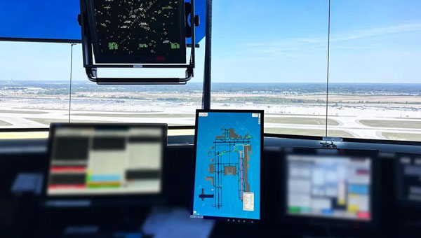
uAvionix has successfully installed and approved its surface situational awareness systems at two major U.S. airports: Indianapolis International Airport (IND) and Austin-Bergstrom International Airport (AUS). Developed in collaboration with Capital Sciences, the systems have passed the Service Acceptance Test (SAT) and will be operational for Air Traffic Control (ATC) starting June 30, 2024.
“This milestone marks the first approvals under the Federal Aviation Administration (FAA) Surface Awareness Initiative (SAI), part of a broader effort to enhance runway safety across the nation,” said Christian Ramsey, chief commercial officer for uAvionix.
The uAvionix systems use the Automatic Dependent Surveillance-Broadcast (ADS-B) service called FlightLine, which offers controllers real-time, precise depictions of aircraft and vehicles on the airport surface. This technology seeks to improve situational awareness and reduce the risk of runway incursions.
The delivery of the FlightLine systems to IND and AUS was completed and accepted within a 90-day timeframe, thanks to close collaboration with the FAA, National Air Traffic Control Association (NATCA), Indianapolis Airport Authority and AUS.
Each airport also installed several of uAvionix’s VTU-20 ADS-B Vehicle Movement Area Transmitters (VMATs) on airport vehicles. The VTU-20 is an FAA-approved system that allows vehicles operating on runways and taxiways to be electronically seen by the tower and aircraft equipped with ADS-B In technologies, further reducing the risk of runway incursions.
Following the success of these implementations, uAvionix will continue working with the FAA to expand the capability to other airports nationwide.
Key benefits of the enhanced system include:
Improved real-time tracking of aircraft and vehicles on the airfield.
Increased safety and efficiency in all weather conditions.
Decreased risk of runway incursions due to timely and accurate data.
SandboxAQ has released AQNav, designed for navigation across air, land and sea when GPS signals are jammed or unavailable.
As of June 2024, AQNav has logged more than 200 flight hours and 40 sorties across multiple regions of the world on four different aircraft types, ranging in size from single-engine planes to large military transport aircraft.
AQNav is a geomagnetic navigation system that uses proprietary artificial intelligence (AI) algorithms, powerful quantum sensors and the Earth’s crustal magnetic field. The system seeks to provide an un-jammable, all-weather, terrain-agnostic, real-time navigation solution in situations where GPS signals are unavailable, denied or spoofed.
The system uses extremely sensitive quantum magnetometers to acquire data from Earth’s crustal magnetic field, which exhibits geographically unique patterns – similar to a human fingerprint. AQNav uses AI algorithms to compare this data against known magnetic maps, allowing the system to quickly and accurately find its position. Due to the high sensitivity of quantum sensors, AI algorithms are applied to improve the signal-to-noise ratio, removing any mechanical, electrical or other interference that would impact the system’s ability to acquire its location.
It is available globally and can be used in air, land and sea applications. The system does not rely on visual ground features or satellite transmissions to function and is not affected by weather conditions.
AQNav operates at room temperature, requires no shielding and has a small form factor that can be integrated into a wide variety of platforms, from multi-engine airliners to UAVs. Its passive technology emits no electronic signals, which reduces the aircraft’s detectability.
AQNav seeks to increase useful navigation for aircraft navigating within the frameworks of regulatory bodies such as the International Civil Aviation Organization and the Federal Aviation Administration (FAA). SandboxAQ and its partners are continuing to explore a broad range of use cases for both commercial and defense applications.
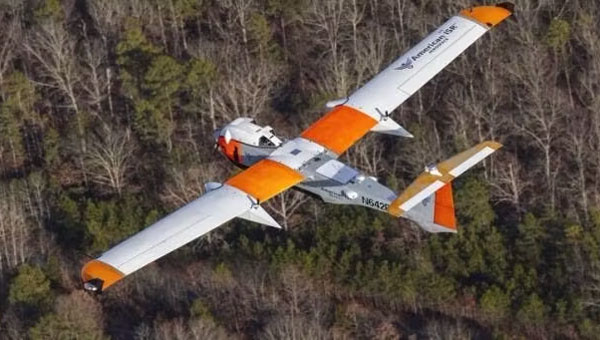
American Aerospace, an Iridium partner, has received a waiver from the Federal Aviation Administration (FAA) to conduct UAV surveillance of critical infrastructure in California’s San Joaquin Valley for Chevron, an oil and gas company.
Enabled by Iridium’s global L-Band satellite connectivity, AATI’s AiRanger UAV will conduct remote aerial surveillance of the energy company’s pipeline and production facilities. Iridium’s network offers beyond visual line of sight (BVLOS) connectivity, including remote command and control (C2) and detect and avoid (DAA) capabilities. The UAV will send information via Iridium satellites to conduct routine inspections.
Iridium partner Blue Sky Network customized and integrated its SkyLink 7100 voice, data and BVLOS terminal on the UAVs. The SkyLink 7100 offers continuous tracking and C2 capabilities for aviation and UAV operations.
The AiRanger is the first UAV to comply with industry standards for the DAA system and meet FAA BVLOS operation requirements. This achievement aims to pave the way for broader use of BVLOS UAVs to enhance situational awareness, reduce inspection costs and maximize value.
Iridium STL is being deployed by L3Harris to protect critical FAA data center infrastructure. (Photo: Iridium)
Iridium Communications has entered a five-year agreement with L3 Harris. Under the agreement, Iridium will provide its satellite time and location (STL) service to more than three dozen L3Harris-operated communications network backbone nodes and a similar number of Federal Aviation Administration (FAA) facilities throughout the United States.
L3Harris, responsible for operating a private network for the FAA, provides voice, data and video communications for the National Airspace System operations and mission support functions. Given the critical nature of timing synchronization within the L3Harris communications network, particularly for supporting various critical infrastructure applications, the Iridium STL service plays a pivotal role in the overall network timing architecture by eliminating dependencies on GPS as the primary timing source.
The solution for L3Harris includes compact devices provided by Adtran’s Oscilloquartz division, which are designed to receive Iridium STL signals. These devices seamlessly integrate into the network and meet nationwide network timing synchronization requirements.
In April 2024, Iridium acquired Satelles, a secure satellite-based time and location service provider.
AUVSI XPONENTIAL 2024 will be held April 22 to 25 at the San Diego Convention Center in San Diego, California.
The event’s key themes include infrastructure and operations, technical research and development, data and analytics, cybersecurity and policy and regulations. The conference will feature keynotes, educational sessions, specialized workshops, and an XPO Hall with more than 30 exhibit categories with technologies across air, land and maritime sectors.
XPONENTIAL attracts more than 7,500 attendees each year, who attend more than 200 educational sessions as part of the full conference. The current keynote sessions include innovators with diverse perspectives and backgrounds who will speak on pressing topics and address key questions affecting the autonomous community.
Confirmed speakers include:
Doug Beck
Director, Defense Innovation Unit
Operationalizing DIU 3.0
Responsible for accelerating the Department of Defense (DoD) adoption of commercial technology through the military, Beck will discuss how defense agencies and industry can collaborate to strengthen national security. This session will be moderated by Courtney Albon, emerging technology reporter for Defense News and C4ISRNET.
Michael Brasseur
Chief Strategy Officer, Saab Inc.
To Create, To Make, To Shape
Drawing upon his role in implementing Saab’s future capabilities strategy, Brasseur’s presentation will address how individuals and organizations can foster an environment of continuous improvement and advancement.
Hal Brands, Ph.D.
Henry A. Kissinger, professor of global affairs, Johns Hopkins School of Advanced International Studies
Advancing Technologies and Their Role in World Affairs
Using his knowledge in foreign policy, international relations and security strategy, Brands will help leaders conceptualize strategies to safeguard national interests and organizations to navigate geopolitical challenges.
Henrik I. Christensen, Ph.D.
Qualcomm chair of robotics and professor, computer science, director of contextual robotics institute, UC San Diego
Looking Ahead: Robotics and Artificial Intelligence
Henrik will explore the future of these technologies and how stakeholders can form strategies that capitalize on emerging opportunities.
Harry Yeff (aka Reeps One)
AI Artist and AI for Good Activist
Undoing a Narrative of Fear
Yeff, a London-born, neurodivergent artist, will share how we can foster a constructive dialogue on responsibly integrating technologies such as artificial intelligence (AI) and autonomy. His performance art pieces, integrated with AI and voice technology, have been exhibited internationally and garnered more than 100 million online views worldwide.
Additionally, a Federal Aviation Administration (FAA) Panel titled “Getting to Go,” will cover safety standards, implementation challenges and obstacles to technology development and testing. Panelists include three representatives from the FAA: Timothy Arel, chief operating officer of the air traffic organization, Marc Nichols, chief counsel and Laurence Wildgoose, assistant administrator for policy, international affairs and environment.
Matt McCardle, head of global regulatory affairs and strategy at Amazon Prime Air will moderate the discussion.
GPS World staff will be attending the conference. To follow our live coverage, click here.
More speakers will be announced in the coming weeks. Click here to learn more and register.
Artist impression; size of debris exaggerated as compared to Earth. (Image: ESA)
So much going on up there!
On Jan.11, speaking at a press briefing in Paris, Javier Benedicto, director of navigation for the European Space Agency (ESA), announced the agency had completed the procurement process for the low-Earth Orbit Positioning Navigation and Timing (LEO PNT) program. ESA expects to have the new LEO PNT demonstration satellites, which will broadcast signals over several frequency bands, up and running by 2026. A positive outcome will most likely lead to the procurement and deployment of a full European LEO PNT constellation for global services.
Also in January, news broke that Google and two of the largest mobile network operators in the world, AT&T and Vodafone, had invested more than $200 million in AST SpaceMobile’s cellular broadband network based on LEO satellites and accessible directly by smartphones. AST SpaceMobile already operates the largest-ever commercial communications array in LEO, the BlueWalker 3 satellite, which, due to its size and brightness, is alarming astronomers.
On Feb. 21, The New York Times reported about U.S. warnings to its allies that Russia might deploy a nuclear weapon in orbit this year. According to the paper, U.S. intelligence agencies told their closest European allies that, “if Russia is going to launch a nuclear weapon into orbit, it will probably do so this year — but that it might instead launch a harmless ‘dummy’ warhead into orbit to leave the West guessing about its capabilities.” A space weapon nested inside a satellite could destroy, jam, or otherwise disable dozens or hundreds of commercial and military satellites in LEO, such as the Starlink satellites that are revolutionizing global communications. See Dana Goward’s analysis.
The next day, Tim Crain, chief technology officer of the Houston-based company Intuitive Machines announced, “Houston, Odysseus has found its new home.” For the first time since Apollo 17 in 1972, a U.S.-built spacecraft had landed on the moon. Odysseus, described by the Times as “a bit bigger than a telephone booth,” (which most people under the age of 20 have never seen), was later confirmed to be upright and sending images. It was delivered into lunar orbit by a SpaceX rocket. NASA hopes this mission will help inaugurate a new era of economical spaceflights around the solar system. Intuitive Machines is one of several small companies the agency has hired to transport instruments to reconnoiter the surface of Earth’s only natural satellite in preparation for the return of NASA astronauts.
My highly synthetic description of the Federal Aviation Administration (FAA) aircraft tracking systems in last month’s First Fix was a bit muddled. Fortunately, I can count on our Editorial Advisory Board member Mitch Narins to clarify:
FAA systems determine an aircraft’s position using a combination of independent and dependent surveillance. Independent surveillance does not require the “cooperation” of the aircraft (e.g., primary radar), while dependent surveillance requires the aircraft to either respond to an interrogation signal or periodically transmit its position — e.g., Automatic Dependent Surveillance-broadcast (ADS-B).
Every day, the Federal Aviation Administration (FAA) monitors and assists more than 45,000 flights — up to 5,000 at any one time — across the more than 29 million square miles that make up the U.S. National Airspace System (NAS). It knows the position of each plane with an accuracy well within its length.
Three key NAS systems are the Automatic Dependent Surveillance-Broadcast (ADS-B), the Airport Surveillance Radar (ASR-11), and the Wide Area Augmentation System (WAAS). They are all part of the Next Generation Air Transportation System (NextGen), a large-scale FAA initiative to modernize the NAS.
ADS-B — which includes ground-based radar and navigational aids and GNSS signals — provides real-time precision, shared situational awareness, and advanced applications for both pilots and air traffic controllers. It enables pilots to see on their cockpit displays what controllers see: other aircraft in the sky.
Relying on satellites instead of ground navigational aids also enables aircraft to fly more directly between airports, reducing flight times, fuel consumption, and air pollution. Furthermore, the improved accuracy, integrity and reliability of satellite signals over radar will enable air traffic controllers to safely reduce the minimum separation distance between aircraft, thereby increasing the number of flights.
ASR-11 is an integrated primary and secondary radar system at terminal air traffic control sites. It interfaces with both legacy and digital automation systems and provides greatly improved local weather forecasts that enhance situational awareness for both air traffic controllers and pilots.
WAAS, a form of a satellite-based augmentation system (SBAS), enables the NAS to provide horizontal and vertical navigation for approach operations for all classes of aircraft in all phases of flight, including vertically-guided landing approaches in instrument meteorological conditions at all qualified locations. It may be further enhanced with ground-based augmentation systems (GBAS) in critical areas.
Through NextGen, the FAA has modernized air traffic infrastructure in communications, navigation, surveillance, automation, and information management with the aim of increasing the safety, efficiency, capacity, predictability, flexibility, and resiliency of U.S. aviation. NextGen includes airport infrastructure improvements, new air traffic technologies and procedures, and safety and security enhancements.
Now, contrast all this with the near inability of the Federal Railroad Administration — tasked with enabling the “safe, reliable, and efficient movement of people and goods” by rail across the United States — to track any of the trains that carry 28 percent of the country’s freight, including many hazardous materials, and to know what they contain. In 2023, there were more than 1,000 train derailments in the United States, most of them in railyards. The derailment in East Palestine, Ohio, a year ago, caused more than $800 million in damages and 80 percent of residents experienced health consequences. Only luck has so far prevented massive loss of life due to a derailment in an urban area. True, the FRA’s operating environment, which includes tunnels and multipath, is very different from the FAA’s, as are its regulatory challenges. Still, tracking where trains are and what they carry would be a great start to addressing the threat of toxic spills.
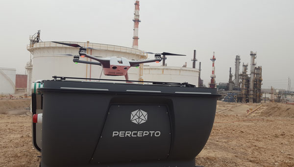
The Federal Aviation Administration (FAA) has granted Percepto a nationwide waiver to operate a full fleet of its UAVs remotely by one operator.
Prior to the approval, Percepto UAVs required one pilot per UAV. Now, users can operate up to 30 drone-in-a-box systems simultaneously with one pilot. The waiver aims to improve the capabilities of beyond visual line of sight (BVLOS) UAV operations across the U.S. By utilizing remote pre-flight checks and advanced automation, this waiver eliminates the need for human interference or expensive radars.
According to the company, the approval is the final regulatory step to achieve large-scale remote UAV operations, following the recent approval for nationwide BVLOS operations.
Percepto’s drone-in-a-box systems consist of a UAV that operates out of a docking station, often used in remote or hard-to-access locations. When set up with a power source and internet connection, the docking station charges and autonomously operates the UAV, allowing operations to run 24/7 and reducing reliance on human presence or interference.
An expert safety review team assembled by the Federal Aviation Administration (FAA) addressed several near-misses at U.S. airports in recent months. The group has called for “urgent action” to be taken to maintain airline safety.
The National Airspace System Safety Review Team released a 52-page report on Nov. 15, which cited air traffic control staffing shortages, technology issues and funding needs as the suspected reasons for the incidents.
The review team, which includes former FAA executives, a former National Transportation Safety Board chairman and former aviation union leaders, was established in April 2023. The group was tasked with examining the air traffic control system and delivering recommendations on how to enhance safety, according to the FAA.
Additionally, the report said that past investments in overhauling FAA technology have worsened the agency’s technology. Newer systems are being layered on top of older systems, and few of the old systems have been decommissioned or replaced, according to the report.
The old systems are becoming difficult to maintain because companies have gone out of business, spare parts are no longer available and the older workers who installed the technologies are retiring without passing knowledge onto younger employees. The equipment replacement backlog is $5.3 billion.
The panel also called for significant changes to the way air traffic controllers are trained. The report said using upgraded simulators and removing “unnecessary and outdated curriculum” could lead to faster certification and more employees.
Transportation Secretary Pete Buttigieg said the FAA is 3,000 controllers short of its goal, and according to the union representing controllers, the ranks grew by only 6% in the past year. If the current hiring plan is followed, only 200 empty seats would be filled, the report said.
The understaffing is causing controllers to work significant amounts of overtime, which the report said is causing “absenteeism, lower productivity and fatigue.”
The report comes as the National Transportation Safety Board is conducting separate investigations into several of the near collisions, one involving a near collision in Boston and a collision involving two private jets in Houston. The near misses have since caught the attention of Congress. A Senate subcommittee held a hearing on Nov. 9, where Jennifer L. Homendy, chairwoman of the National Transportation Safety Board, stressed the importance of safety checks to maintain airline safety.
SwissDrones, a global manufacturer and operator of long-range uncrewed helicopter systems for inspection, surveillance and public safety applications, has announced its SDO 50 V2 multi-mission, single-turbine uncrewed helicopter system has received Federal Aviation Administration (FAA) authorization.
This authorization allows aerial service provider Phoenix Air Unmanned (PAU), partner of SwissDrones, to operate the SDO 50 V2 beyond visual line of sight (BVLOS) across the U.S. This achievement marks the first-of-its-kind authorization within the United States, allowing PAU to broaden its capabilities in inspection, patrol and survey missions over extensive distances.
SwissDrones and PAU collaborated over the course of three years to build a concept of safe BVLOS operations (CONOPS) and conducted numerous flight trials in the U.S. using the SDO 50 V2. All regulatory and safety requirements were met in cooperation with the FAA to enable extended-range inspection and patrol flights over linear infrastructure under the same regulations as traditional-crewed aircraft.
PAU intends to use this aircraft for a variety of data-gathering tasks, including high-resolution imaging, lidar data collection and thermal imaging.
Depending on the specific sensor package and operating area, PUA inspection flights can span distances of more than 60 miles, allowing operators to conduct multiple inspections efficiently within a single flight.
With a maximum weight of 191 pounds, the SDO 50 V2 can carry sensors weighing between 30 and 70 pounds and maintain flights lasting over three hours. These extended flights make it ideal for missions requiring multiple sensors, offering nearly ten times the endurance and three times the lift capacity compared to aircraft weighing under 55 pounds that operate under Part 107 waivers.
The SDO 50 V2 has also received a Special Airworthiness Certificate (SAC-EC) from the FAA. SwissDrones is among the first organizations to obtain a European drone operator license, the European Union Aviation Safety Agency (EASA) Light UAS Operator Certificate (LUC). This certificate grants SwissDrones the authority to self-authorize flight operations for its aircraft across EASA countries, encompassing BVLOS operations within the specified certificate limits. Additional regulatory approvals from civil aviation authorities will be announced in the coming months.
The natural sciences overlap — hence such fields as geophysics, astrobiology and biochemistry. So do the social sciences and humanities — hence such fields as political economy, political philosophy and social economics. Our very individual identities consist of multiple, intersecting factors — including gender, race, ethnicity, class, and sexuality.
Analogously, this magazine covers overlapping technologies. While we focus on global navigation satellite systems (GNSS) and other positioning, navigation and timing (PNT) technologies such as inertial systems, these technologies are often embedded in larger systems that also include sensors (such as lidar, radar and cameras) and, increasingly, artificial intelligence (AI).
That is why we so often cover unmanned aerial vehicles (UAV) — which use GNSS for positioning navigation, geofencing and stabilization; use sensors to collect data; and will soon use AI for mission planning and execution — and autonomous vehicles — which use GNSS and sensors for positioning and navigation and already use AI to make driving decisions in complex environments.
Of course, UAVs are also much in the news these days:
Since the start of the Russian invasion of Ukraine, both sides have been using several hundred UAVs every day. According to the Royal United Services Institute, a British think tank, the Ukrainians are losing some 10,000 UAVs a month on the battlefield. (By way of comparison, the French army currently has a little more than 3,000 UAVs in its arsenal.)
In the United States, the number of companies granted waivers by the Federal Aviation Administration to conduct beyond visual line of sight (BVLOS) operations keeps growing, enabling them to conduct much more efficient monitoring, inspections and mapping of infrastructure.
Following a recent increase in encounters between swimmers and sharks along beaches on Long Island, New York, in July UAVs began sweeping the ocean three times a day to detect danger. On July 14, the state’s governor, Kathy Hochul, announced the allocation of $1 million to purchase 60 new shark-monitoring UAVs.
Also in July, 350 UAVs were lost during a practice light display show in Melbourne, Australia, ahead of a scheduled performance for the opening of the women’s World Cup. The UAVs appeared to stop mid-show and plummet into the Yarra River, most likely due to interference with GPS signals.
On August 30, researchers in Switzerland unveiled a small AI-powered quadcopter UAV that can outfly some of the best human competitors in the world. It whipped its way around an indoor racecourse in a matter of seconds and was able to beat its human rival in 15 out of 25 races, according to the journal Nature.
From mapping coastal areas with airborne lidar bathymetry to delivering medicines, from locating lost hikers to mapping fires, from enhancing the situational awareness of first responders to monitoring invasive plant species, UAVs are quickly becoming ubiquitous and essential.
Meanwhile, in San Francisco, where autonomous vehicles are already ubiquitous, but not everyone considers them essential, an anonymous group of protesters is surreptitiously placing orange traffic cones on some of them, confusing their sensors and rendering them inoperable.
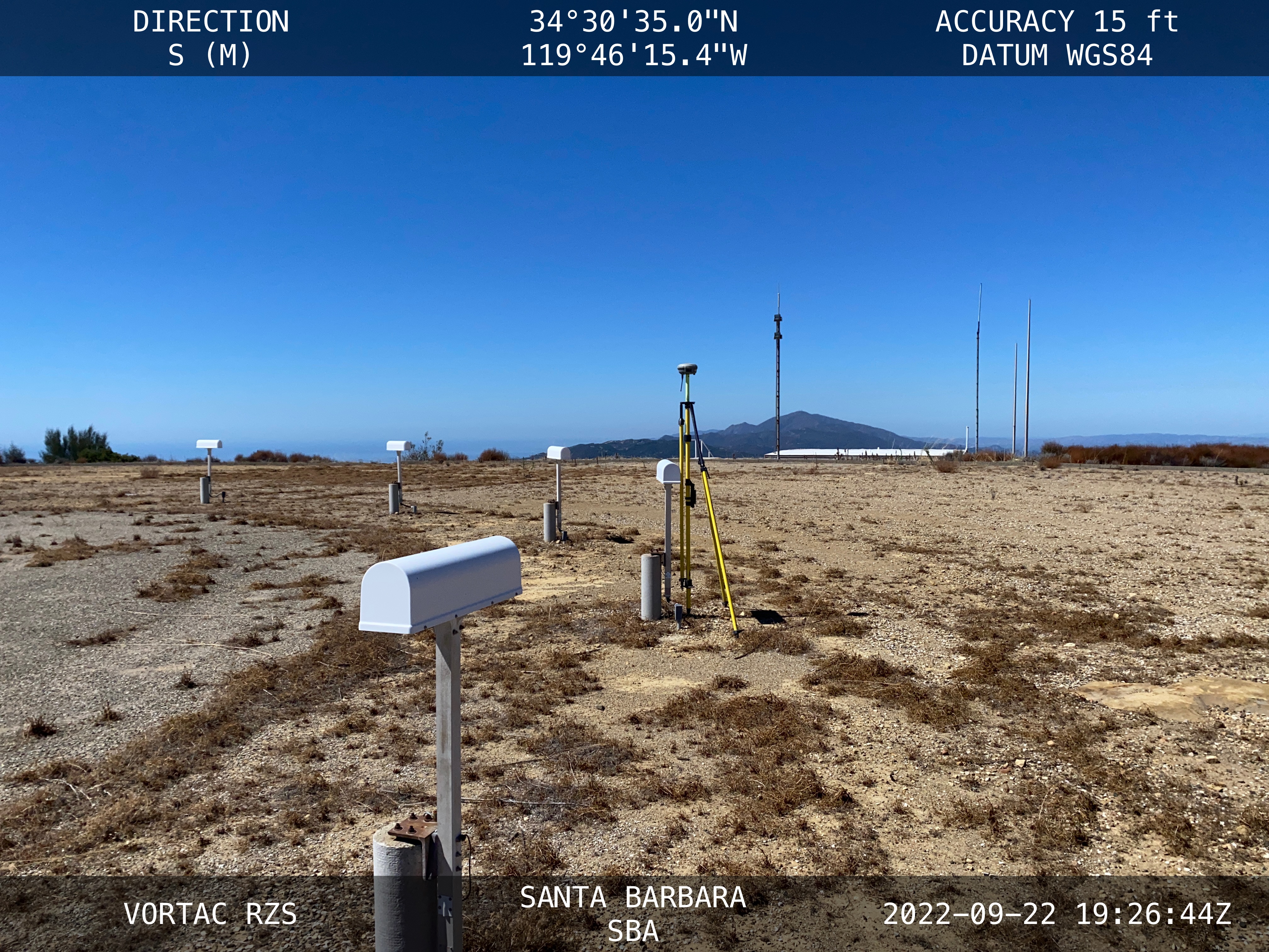
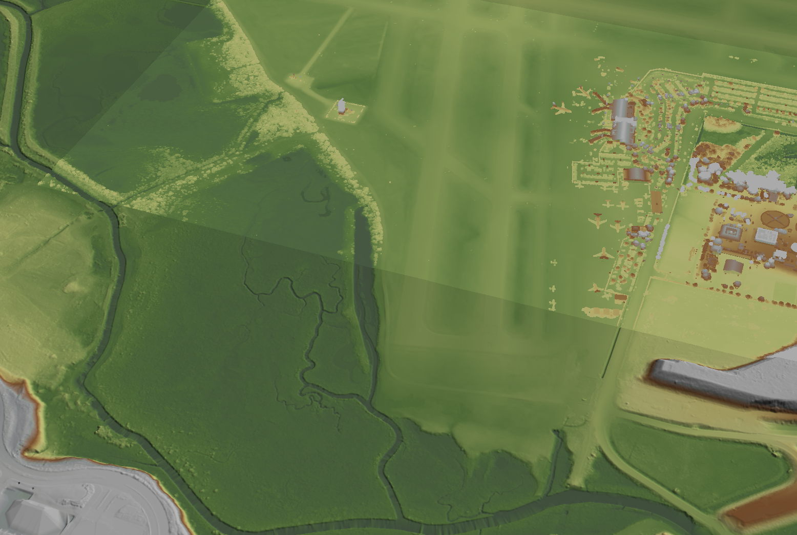
NV5 Geospatial, a large geospatial data company, provides services for airport projects across the United States and U.S. territories — mainly supporting airport planning and engineering firms that must meet FAA survey and mapping requirements for data collection at airports. “We generally are a sub-consultant to them, helping them achieve those survey standards for collecting the data and submitting it to the FAA,” said David Grigg, the company’s Aviation Program Director. Typically, this is around planning projects such as airport layout plans and master plans, but also engineering projects such as runway extensions and runway reconstructions.
As an example, Grigg cited the extension of a runway, which requires new flight procedures to be established. “Two survey missions are required for runway extensions. The primary mission is to establish control for the aerial imagery. Using the imagery, control and design data, we check for obstacles photogrammetrically. That data is sent to the FAA and procedures are developed. After construction is complete, we go back to the airport to survey the changed runway and navigational aids (NAVAIDS) to verify that what was designed was ultimately built.”
Another way in which NV5 Geospatial supports airport clients is by conducting obstruction studies around them for vegetation management. “That’s generally where we pull in the lidar surveys,” said Grigg. The FAA’s standards for relative and absolute positioning accuracy for trees are “rather generous” by surveying standards, he said. “We’re talking two to three feet vertically and twenty feet horizontally. It’s not like a typical mapping job where you’re guaranteeing it to one foot or better horizontally and half foot or better vertically.”
The FAA, he points out, has published guidance on how lidar may be used. “We mostly use aerial photogrammetry to support projects in the FAA’s airports GIS program. When we collect lidar at an airport, we do it to generate contours and to identify individual tree canopies. Our lidar-derived data is most often developed to benefit airports for tree mitigation not for FAA airports GIS survey projects.”
Image: NV5 Geospatial
On the other hand, the FAA has strict requirements regarding metadata to document when, where, and how each control point is collected. “At the time of the survey, photographs are taken of the GPS units from different angles and cardinal directions,” Grigg said. “This is visual documentation for NGS that the surveyed point is at the location described. ”
Another challenge for surveyors working at airports is that they are required to pull back for incoming aircraft. “Obviously, you will have some logistical issues at busy airports,” said Grigg. Surveyors are required to have special lights and markings on any vehicles that enter the airport property to ensure ground and air visibility. Aircraft movement also impacts surveyors as they must move away from the runway safety area (RSA) for take-offs and landings. Busier airports are surveyed at night, when air traffic is reduced or runways are closed.
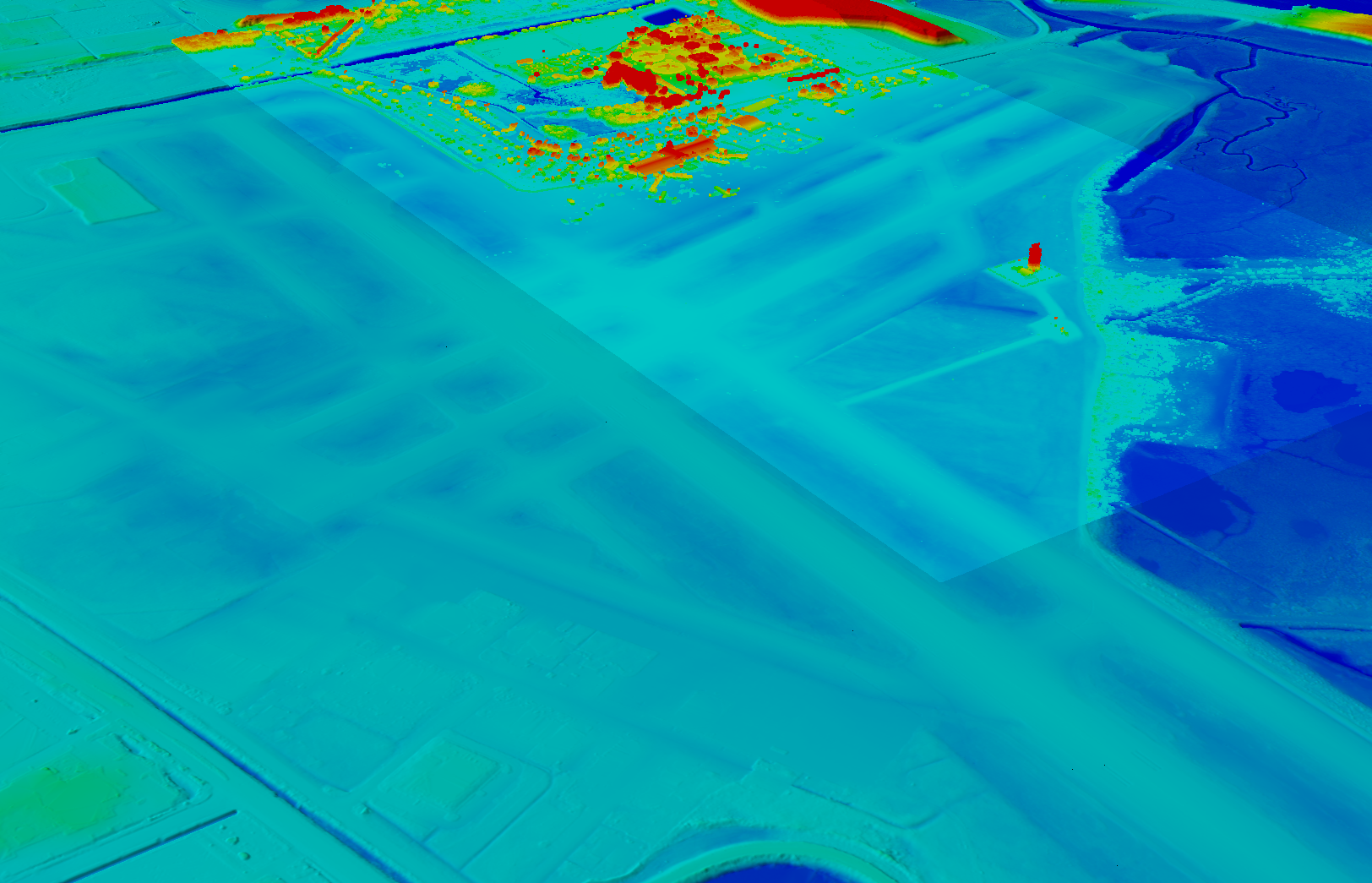
Image: NV5 Geospatial
A typical project for a small airport takes about nine months, while for bigger airports — such as Chicago O’Hare, Dallas-Fort Worth, or Hartsfield-Jackson Atlanta — they can take up to twice as long. “The large hubs update their master plan on a more reoccurring basis, such as every three to five years,” said Doug Fuller, NV5 Geospatial’s Airport Solutions Specialist. “As the airports get smaller, you start stretching out that timeframe.”
Airport survey requirements
[The following was written by NV5 Geospatial and only lightly edited by GPS World.]
Airports have surveys conducted for many different reasons. However, all survey types require the collection, classification and reporting of accurate data about the project. The methodology selected to gather the information is up to the professional surveyor’s judgment. Some features require observation through ground field methods, while others lend themselves to collection via remote sensing technologies.
All surveys start with a search for existing airport control, which are called Primary Airport Control Points (PACS) and Secondary Airport Control Points (SACS). These are points on the airport that have been adjusted by the National Geodetic Survey (NGS). This ensures that the survey is done on the National Spatial Reference System (NSRS).
A typical survey includes surveying the runway, the end points, any displaced thresholds, and a profile along the centerline of the runway. If the centerline marker is not in the correct location or if it is not there at all, the surveyor will make the necessary measurements to establish the proper location and set a new marker. Next the surveyor must locate all NAVAIDS and survey them at the proper location as described in FAA Advisory Circular 150/5300-18B.
After the NAVAIDS are located, the photo control survey will be done. This still requires the PACS and SACS to be the points of origin of the survey. The base requirement as described in FAA Advisory Circular 150/5300-16C is to survey ten photo control points and five check points. The check points are sent to NGS’s Online Positioning User Service (OPUS). This is used to check that the survey was done on the NSRS and that the compilation meets FAA standards.
The standards the surveyor must meet vary depending on the equipment type or photo control point. Examples of the accuracy requirements for the NAVAIDS are as follows:
Point
Horizontal
Vertical
Distance measuring equipment
+/- 1 ft
+/- 1 ft
Glideslope
+/- 1 ft
+/- 0.25 ft
Inner marker
+/- 10 ft
+/- 20 ft
Localizer
+/- 1 ft
+/- 0.25 ft
Runway end point
+/- 1 f ft
+/- 0.25 ft
Runway profile points
+/- 1 f ft
+/- 0.25 ft
Photo control
+/- 1 ft
+/- 1 ft
PACS and SACS
X
Y
Z
Ellip.
Inverse from PACS to SACS
surveyed relative to published
0.09 ft
0.09 ft
0.15 ft
0.13 ft
When surveying on airport property, the largest challenge is always accessing the runway safety area to locate the runway ends and profiles. At small airports Surveyors must work when the runway is not busy; at airports with FAA control towers when the runway is closed. Frequently this is done overnight. Other challenges include access to the FAA NAVAIDS. Some of them must be turned off to be surveyed and others require survey points on which it is not possible to set an instrument. When we are not able to occupy a point, we collect it by surveying multiple equidistant locations around the NAVAID and averaging them.
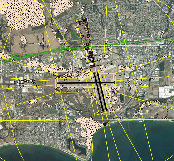
Image: NV5 Geospatial
NV5 Geospatial surveyors use a combination of real-time (R/T) and post-processing techniques. We also use OPUS with the PACS and SACS and the five check points. Once the PACS and SACS have been determined to be stable, the proper coordinates are applied to them and the R/T points are adjusted using Trimble Business Center (TBC). NV5 Geospatial uses Trimble TRM-R8s and we recently added TRM-R12i receivers to our equipment. We use ground control points to orient the photography and to calibrate the lidar.