Amazon.com is warning the Federal Aviation Administration (FAA) that it will move its drone research abroad if it doesn’t get permission soon to test-fly in the United States, reports TheWall Street Journal. Amazon has already begun researching drone flights in the United Kingdom.
“Without the ability to test outdoors in the United States soon, we will have no choice but to divert even more of our [drone] research and development resources abroad,” wrote Amazon’s vice president of global public policy Paul Misener in a letter to the FAA, according to The Wall Street Journal. “I fear the FAA may be questioning the fundamental benefits of keeping [drone] technology innovation in the United States,” Misener wrote.
The FAA is required by U.S. Congress to frame a “safe integration” plan for the commercial use of UAS by Sept. 30, 2015. Changes in the law could restrict users of commercial UAVs by requiring licenses, with licenses issued to users only after many hours in the cockpit of a manned aircraft, comparable to traditional pilot licenses. The new rules would also limit flights to under 400 feet and within sight of the person at the controls, which is the current rule for hobbyists.
One of the FAA’s concerns is conflicts with manned aircraft. FAA data shows dozens of dangerous encounters around the country over the past six months, according to the Washington Post. Since June 1, commercial airlines, private pilots and air-traffic controllers have alerted the FAA to 25 episodes in which small drones came within a few seconds or a few feet of crashing into much larger aircraft. Many of the close calls occurred during takeoffs and landings at the nation’s busiest airports, presenting a new threat to aviation safety after decades of steady improvement in air travel.
Read one blogger’s account of a close call using a drone, partly caused by loss of the GPS signal.
CompassData, a provider of geospatial data and services, announced that its CompassTA elevation accuracy software has received OCIO-ITS certification from the U.S. Department of Agriculture (USDA). Certification allows 40,000 USDA users the opportunity to utilize CompassTA software for elevation accuracy verification of LiDAR point clouds, digital elevation models (DEM), and other raster data sets.
“This certification provides assurance to our current and future USDA clients they are using a data verification tool that has been thoroughly scrutinized and tested by their own internal auditing process,” said Jeff Barker, CompassData product manager.
USDA certified the CompassTA software through the Office of the Chief Information Officer – Information Technology Services (OCIO-ITS) within the Device Deployment Services Branch.
Earlier this year, CompassData received DO-200A approval from the Federal Aviation Administration (FAA) to use its CompassAA software and ground control points (GCPs) to verify the accuracy of satellite and aerial imagery for the creation of certain aviation products.
CompassTA and CompassAA are software tools in CompassData’s CompassV&V line of Verification and Validation products. Based on the popular Topo Analyst and Accuracy Analyst software tools CompassData purchased from Spatial Information Solutions (SIS) in early 2014, the rebranded CompassV&V products include CompassAA, for orthorectified image verification, and CompassTA, for QA/QC of elevation data.
For 20 years, CompassData has performed custom GCP collection for clients in the geospatial profession and archived those points in a database for commercial sale to other end users. The CompassV&V tools are used extensively with custom and archived GCP to verify the accuracy of geospatial imagery, surface and elevation models and many other spatial products.
Used by numerous U.S. federal agencies under the SIS brand names, CompassV&V tools are content enhancement solutions that automate map accuracy verification and eliminate manual processing, ensuring consistent quality control of geospatial products backed up by standardized reporting procedures. Both tools establish automated workflows and generate standards-based documentation delivered along with end products.
“Since acquiring and rebranding the CompassV&V tools, we have made administrative upgrades to enhance the user experience,” said Barker. “Additional improvements are in the works.”
Leveraging the CompassV&V software tools, CompassData has expanded its custom Validation Service using GCPs. This service is offered for clients who prefer, or are required, to have an independent third-party perform quality assurance and supply verification reports, CompassData has licensed professionals on staff that perform Validation Services using high-quality GCPs along with the CompassV&V tools. The CompassData team can conduct this service faster and at lower cost than other firms that have to obtain their own GCPs.
The U.S. National Transportation Safety Board has ruled that drones are aircraft for the purpose of the Federal Aviation Administration’s prohibition of their careless or reckless use.
The NTSB affirmed the agency’s position that unmanned aircraft systems (UAS) meet the legal definition of “aircraft,” and that the agency may take enforcement action against anyone who operates a UAS or model aircraft in a careless or reckless manner.
The FAA appealed a decision by an NTSB Administrative Law Judge in Huerta v. Pirker, after the judge dismissed the FAA’s order requiring Raphael Pirker to pay a civil penalty of $10,000 for operating an unmanned aircraft in a careless or reckless manner at the University of Virginia in October 2011.
The FAA said in a statement, “The FAA believes Mr. Pirker operated a UAS in a careless or reckless manner, and that the proposed civil penalty should stand. The agency looks forward to a factual determination by the Administrative Law Judge on the ‘careless or reckless’ nature of the operation in question.”
Commercial drones are currently banned in the U.S., except for certain exemptions like one announced in September for some TV and movie production companies, as reported by PC World. Amazon.com and Google have said they plan to use drones to deliver goods. The FAA is required by U.S. Congress to frame a “safe integration” plan for the commercial use of UAS by Sept. 30, 2015.
The NTSB was ruling in an appeal against an FAA order that imposed a fine of $10,000 on aerial photographer Raphael Pirker in October 2011 for flying recklessly a powered glider aircraft near University of Virginia at Charlottesville, Virginia. Pinker was said to have been hired to supply aerial photographs and video of the university campus and medical center. He had argued that his aircraft, which was described as an UAS, was in fact a model aircraft.
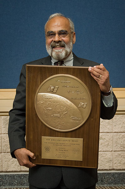
The Institute of Navigation’s (ION) Satellite Division awarded Pratap Misra its Johannes Kepler Award on September 12 at the ION GNSS+ Conference in Tampa, Florida, for his contributions to satellite navigation education, the understanding of GLONASS, and receiver autonomous integrity monitoring.
Misra is credited with tracking GLONASS satellites using the AF Deep Space Tracking Network to determine their orbits in the coordinate frame used by GPS, while the satellites broadcast their positions in the Soviet coordinate frame. Misra is recognized for his ground-breaking work on navigation with combination of GPS and GLONASS signals and is the western world’s leading expert on what’s now the Russian satellite navigation system. He was a technical advisor to the Federal Aviation Administration for many of the bilateral and multi-lateral committees that worked on the development of GPS/GLONASS spectrum sharing and avionics.
Additionally, Misra has worked on receiver autonomous integrity monitoring (RAIM), and contributed a novel approach that does not require the simplifying assumption of Gaussian errors. He was also the first to provide a RAIM algorithm that leveraged the receiver clock to put a bound on the vertical position error. These algorithms are expected to play a significant role in the upcoming multi-constellation environment.
Misra is a research associate professor of Mechanical Engineering at Tufts University, and is well known for the textbook that he co-authored with Professor Per Enge of Stanford University, Global Positioning System: Signals, Measurements and Performance. Misra is a past chair of the ION Satellite Division and has held numerous volunteer positions within ION, most recently focusing on the support of student programs. He is both an ION Fellow (2003) and IEEE Fellow (2007).
The Kepler Award recognizes and honors an individual for sustained and significant contributions to the development of satellite navigation. It is the highest honor bestowed by the ION’s Satellite Division.
Like it or not, as a person who works with geospatial data, UAS (unmanned aerial systems such as drones and UAVs) are in your future. The upside of said technology for “quick and dirty” mapping is undeniable.
GNSS plays a key role with UAS, just like it plays a key role in classical photogrammetry. In fact, UAS may even push GNSS technology into areas where it hasn’t gone. For example, L1 RTK. I wrote about L1 RTK technology several years ago, and while several products attempted to exploit it, L1 RTK never was adopted in any significant numbers, primarily due to the short baseline, clear sky, and longer initialization requirements. However, UAS may change that because, by their nature, they work with short baselines, clear sky environments and require some setup time, at least enough for L1 RTK initialization.
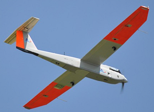
However, before we get ahead of ourselves, the regulatory machine (the Federal Aviation Administration) must publish regulations that provide guidelines on the use of UAS for commercial operations. In June, amidst its recent enforcement actions, the FAA issued its first commercial authorization for mapping UAS over land in the U.S. The FAA issued a Certificate of Waiver or Authorization (CoA) to BP to conduct aerial surveys in Prudhoe Bay, Alaska. According to the FAA, the first flights took place on June 8 and used a AeroEnvironment 13.5 lb. Puma AE fixed-wing UAS with a nine-foot wingspan.
According to a Wall Street Journal article, AeroEnvironment spokesman Steve Gitlin said it took about a year and considerable financial investment to win FAA approval for the BP project. Curt Smith, a director in BP’s technology office, said that manned aircraft are sometimes less expensive per flight than the AeroVironment devices, but that the drones will gather far more data, enabling BP to operate “more effectively, more safely, and at a lower cost.”
The FAA announced that last summer that it issued restricted category type certificates to the Puma and Insitu’s Scan Eagle, another small UAS. The certificates were limited to aerial surveillance only over Arctic waters. The FAA recently modified the data sheet of the Puma’s restricted category type certificate to allow operations over land after AeroVironment showed that the Puma could perform such flights safely.
Texas A&M University Becomes Fourth Operational UAS Test Site
In further UAS news, the FAA announced on June 20 that Texas A&M University – Corpus Christi became the fourth of six UAS test sites to become operational. The FAA issued a CoA for the university to use an 85 lb AAAI RS-16 UAS with a ~13-foot wingspan. The other five UAS test sites are Griffiss (NY) International Airport, North Dakota Department of Commerce, State of Nevada, University of Alaska, and Virginia Polytechnic Institute and State University.
American Aerospace RS-16 UAS. 12’11” Wingspan. 85 lbs.
The FAA UAS Legal Stuff
Despite its setback when an NTSB administrative law judge ruled against the FAA in March 2013, the FAA sternly maintains its position that commercial operations of UAS in the U.S. are strictly prohibited without a CoA. In fact, just this week (June 23), the FAA issued a press release about a Federal Register Notice the FAA published of its interpretation of UAS rules for model aircraft in the FAA Modernization and Reform Act of 2012. In the Act, the Sec. 336 Special Rule for Model Aircraft reads:
SEC. 336. SPECIAL RULE FOR MODEL AIRCRAFT
(a) IN GENERAL.—Notwithstanding any other provision of law relating to the incorporation of unmanned aircraft systems into Federal Aviation Administration plans and policies, including this subtitle, the Administrator of the Federal Aviation Administration may not promulgate any rule or regulation regarding a model aircraft, or an aircraft being developed as a model aircraft, if—
(1) the aircraft is flown strictly for hobby or recreational use;
(2) the aircraft is operated in accordance with a community-based set of safety guidelines and within the programming of a nationwide community-based organization;
(3) the aircraft is limited to not more than 55 pounds unless otherwise certified through a design, construction, inspection, flight test, and operational safety program administered by a community-based organization;
(4) the aircraft is operated in a manner that does not interfere with and gives way to any manned aircraft; and
(5) when flown within 5 miles of an airport, the operator of the aircraft provides the airport operator and the airport air traffic control tower (when an air traffic facility is located at the airport) with prior notice of the operation (model aircraft operators flying from a permanent location within 5 miles of an airport should establish a mutually-agreed upon operating procedure with the airport operator and the airport air traffic control tower (when an air traffic facility is located at the airport)).
(b) STATUTORY CONSTRUCTION.—Nothing in this section shall be construed to limit the authority of the Administrator to pursue enforcement action against persons operating model aircraft who endanger the safety of the national airspace system.
(c) MODEL AIRCRAFT DEFINED.—In this section, the term ‘‘model aircraft’’ means an unmanned aircraft that is—
(1) capable of sustained flight in the atmosphere;
(2) flown within visual line of sight of the person operating
(3) the aircraft; and
(4) flown for hobby or recreational purposes.
You can read more (lots more) about the FAA’s interpretation of the Act here. You can submit a comment on the FAA’s interpretation of the Act here. The comment period ends July 25.
More FAA UAS Legal Stuff
On June 25, the FAA issued a press release announcing that seven aerial photo and video production companies requested regulatory exemptions from the FAA to operate UAS before the FAA UAS rule-making is finalized. According to the FAA, “the Motion Picture Association of America facilitated the exemption requests on behalf of their membership. The firms that filed the petitions are all independent aerial cinematography professionals who collectively developed the exemption requests as a requirement to satisfy the safety and public interest concerns of the FAA, MPAA, and the public at large.”
From the FAA press release, “The FAA published a brief summary of the petition from Astraeus Aerial in the Federal Register. The agency opted to ask for comments only on the Astraeus petition because that company’s request came in first, and the petitions from the other six companies ask for identical exemptions.”
Interestingly enough, the FAA is soliciting public comment before it makes a ruling on the MPAA request, clearly highlighting the tremendous pressure the FAA is under to integrate commercial use of UAS in the U.S.
More Commercial Use of UAS Despite what the FAA Says
The NTSB ruling against the FAA fueled the commercial UAS fire and certainly gave commercial UAS operators, operating illegally according to the FAA, more confidence that the FAA may not pursue them. That might be the case in an incident publicized last week in Seattle, Washington, where a woman called police after she saw a UAS buzzing around outside of her apartment building, believing it was spying on her 26th-floor apartment. The Portland, Oregon-based UAS operator, Skyris Imaging, was interviewed by Portland’s KATU news.
“It was not our intent to view anything other than the views from a 20-story office building that will be built across the street,” said Skyris’s Joe Vaughn. Vaughn told KATU that a Seattle-based developer hired Vaughn’s company to use one of his drones equipped with cameras to take photos of the view for a new 20-story building.
Vaughn told KATU that his company has a fleet of six drones he says he responsibly flies. He told KATU that his company has strict guidelines to never fly for a third party, over crowds, above 400 feet, or beyond visual range. Click below to view the KATU interview.
Live Webinar at the Esri International User Conference
In a GPS World first, we’ll be producing a live webinar from the Esri International User Conference on Thursday, July 17, @ 10 a.m. Pacific Time in the exhibit hall at the San Diego Convention Center. Of course, the webinar will be focused on one of the hottest topics: high-precision mobile GIS. It will cover high-precision GNSS on mobile devices, from iPads to Android tablets to smartphones.
Tune in or join us live from the exhibit hall floor! Register here.
A new emergency locator transmitter for aviation has received Cospas-Sarsat and FAA approvals and is now available for sale. The ELT 1000 by ACR Electronics, Inc., is designed with multiple installation configurations to reduce overall installation cost, the company said.
The electronics maximize frequency stability and power while incorporating a new, built-in GPS navigational interface, the company said. Including GPS data in the emergency transmission allows search-and-rescue personnel to know the location within 100 meters in less than a minute. Designed to accommodate multiple installation configurations, the new ELT 1000 is a quick retrofit for obsolete 121.5 MHz ELTs.
“We are very excited to announce this new ELT to the general aviation market. This is the first new ELT from the Artex family in many years and the first we have designed and certified at ACR. We feel we are bringing an ELT that offers excellent value, along with the highest quality workmanship available to the market,” said Gerald Angeli, president and general manager.
Built under the exacting standards of AS9100C quality certification, the ELT 1000 exceeds all government and regulatory standards including the latest FAA guidelines with its new robust stainless steel mounting strap.
ELT 1000 features and specifications:
Quick and easy retrofit for general aviation aircraft
Single antenna output for emergency transmission on both 406 MHz (Cospas-Sarsat) and 121.5 MHz frequencies (local Search & Rescue)
Enhanced positional accuracy with a built-in GPS interface that does not require aircraft power
Encoded digital message broadcasts aircraft identification/registration and owner/emergency contact details
New stainless steel mounting strap for increased stability that complies with the most current FAA guidelines
Simple self-testing from the cockpit. When combined with 406Test.com, the self-test will provide SMS/e-mail confirmation within seconds that the ELT signal reached the satellites successfully
New hermetically sealed G-Switch for increased reliability.
Interview with Graham Purves, Executive Vice President, NovAtel
Graham Purves, NovAtel
GPS World (GPSW): In the regulatory picture for unmanned autonomous vehicles (UAVs), what are the concerns for the GNSS research, design, and manufacturing community regarding air-space regulation?
Graham Purves (GP): The main concern is the scope and impact of certification requirements for UAV navigation systems in the National Air Space. Certification places constraints on software complexity, so it is difficult to define solutions if the certification framework is unclear.
In the context of current avionics for civil aviation, design standards and certification requirements are well defined. In the case of pilot-less aircraft, the navigation systems may make use of additional features and technologies that are not part of the current certification paradigm. Examples are tightly coupled inertial navigation systems (INS) for flight control and redundancy, and real-time kinematic (RTK) and differential GPS for landing and capture. Certification requirements and design assurance levels for these features will have a major impact on the definition and design process, and may even prevent some effective technical solutions from being used, due to the software complexity. Of course, communications and communication standards will also present a significant hurdle.
GPSW: What are the concerns for the GNSS research, design, and manufacturing community regarding vehicle/road regulation for UGVs?
GP: Similar answer. The software used in positioning and navigation systems is significantly more complex than the safety-critical software in current automotive systems. Regulation for UGVs may result in restrictive certification requirements that affect or prohibit the use of more complex software. Until we have a clear understanding of the certification framework, it is difficult to define technical solutions.
GPSW: In looking forward to the Federal Aviation Administration tests at six sites for integrating unmanned aerial vehicles into the commercial airspace safely, what are some of the technical challenges that you (and presumably NovAtel’s partners) are facing?
GP: We have proven some excellent technical solutions in the non-civil applications and believe the main barrier is not a technical but a regulatory challenge.
GPSW: What other pieces/technologies do you have to pull into the UAV/UGV integration to make it work? Inertial, certainly. What else?
GP: The UAV/UGV application is a very interesting arena for other positioning technologies that either augment or complement GNSS. Apart from navigation and auto-pilot functions, we believe the sense-and-avoid functions will require other sensing technologies, like scanning lasers. When you include the mission-related functions that require precise steering, pointing and measuring systems, the UAV/UGV is a very exciting category for companies like NovAtel.
GPSW: Is UAV/UGV a game-changer for the GNSS industry? Similar to the cellphone/smartphone implementation of GNSS chips, which created a whole new sector?
GP: It does have two elements that might be considered game-changers:
The movement of GNSS and other positioning technologies into a safety-critical role. It seems inevitable that someday we will live in a world where autonomous vehicles are the norm, and the idea of having a human behind the wheel is both complex and unsafe.
The UAV/UGV is an enabling technology and a platform for innovation. Similar to the wireless revolution, the killer applications may well be things we haven’t yet conceived of.
Graham Purves has been active in the GNSS industry since 1990, starting in ASIC development and continuing with various technical and business positions within NovAtel over the last 26 years.
CompassData, a worldwide provider of geospatial data and services, has received DO-200A certification by the Federal Aviation Administration (FAA) for collection and processing of survey and ground control data used in the creation of Airport Mapping Database (AMDB) products.
“DO-200A certification enables CompassData to provide Ground Control Points (GCPs) for generation of digital aeronautical products, such as Airport Moving Maps, used by pilots in the cockpit to navigate on the ground at airports worldwide,” said Hayden Howard, CompassData Vice President. “This certification applies to custom ground control collects and to many of the GCPs that exist in our worldwide archive available off the shelf for immediate purchase.”
In addition, CompassData has been approved to use its GCPs and Accuracy Analyst map tool to verify the accuracy of satellite or aerial imagery used in creation of AMDB DO-272C aviation products. This means CompassData may orthorectify a high-resolution DigitalGlobe satellite image, verify that the orthoimage accuracy meets sub one- and five-meter specifications, and provide the image to an aeronautical mapping firm or avionics system developer to generate commercial products.
DO-200A standards were developed by FAA to assure the quality of data used in the preparation of aeronautical mapping, navigation and situational awareness products and systems. Prior to certification, CompassData completed a rigorous examination procedure in which FAA reviewed every step in the firm’s methodologies for collecting, processing and managing GPS-surveyed ground control to ensure the data is accurate, timely, complete, and traceable.
FAA has granted only six LOAs (Letters of Acceptance) in the Denver ACO Region and only 24 globally. CompassData is the first in the world to receive certification for verification of data sets used to create Airport Moving Map data.
In March, CompassData purchased the assets of Spatial Information Solutions (SIS) in Starkville, Mississippi, and announced the continued sale and support of the popular Accuracy Analyst and Topo Analyst Map Accuracy Tools. These software applications are relied upon by geospatial end users to automatically verify the accuracy of orthoimagery and digital elevation data sets, often with CompassData GCPs.
CompassData will discuss the FAA DO-200A certification and demonstrate Accuracy Analyst and Topo Analyst Map Accuracy Tools in booth #2063 at GEOINT 13* being held April 14-17, 2014, in Tampa, Florida.
Plans to harness Galileo and other satnav systems for next-generation satellite augmentation systems for aviation and other high-performance uses took a significant step forward at the latest gathering of worldwide operators and experts, reports the European Space Agency.
Satellite augmentation systems combine additional ground stations and satellite transponders to sharpen satnav accuracy and reliability across given geographical regions — based on the U.S. GPS for now, but with plans to move to a multi-constellation design additionally employing Europe’s Galileo, China’s BeiDou, and Russia’s GLONASS systems in the post-2020 era.
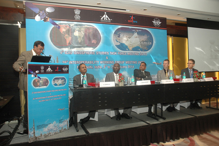
The 26th Satellite Based Augmentation Systems (SBAS) Interoperability Working Group (IWG) took place in New Delhi, India on February 5–7.
The 26th SBAS Interoperability Working Group (IWG) was introduced by V. Somasundaram, board member of the Airport Authority of India.
Among its achievements was to converge on a standard message definition for one of the channels — known as L5 — of the planned second-generation SBAS systems, which will utilize dual-frequency, multi-constellation signals.
“Two solutions had been put forward, one by ESA based on work by European industry and one from the U.S. Federal Aviation Administration and Stanford University,” explains ESA’s Didier Flament, co-chair of the IWG.
“A single definition coordinated between both bodies has been presented, combining the benefits of both solutions. The formal IWG review and approval loop has now been started with the objective of finalizing it for September’s IWG meeting.
“The aim is to have it ready to submit to the official international SBAS standardization bodies — the International Civil Aviation Organization and the Radio Technical Commission for Aeronautics — as soon as October.”
The meeting also marked the significant progress made by Indian’s own SBAS system GAGAN, which underwent its final stability test last summer, followed by its safety certification in December.
At this point GAGAN was declared certified for non-precision approach users , followed by its safety-of-life service being formally offered to civil aviation users on 14 February.
GAGAN has been jointly undertaken by the AAI and the Indian Space Research Organisation, intended to provide improved accuracy, availability and integrity necessary to enable users to rely on satnav signals for all phases of flight – from en route as well as approach to all qualified airports within the GAGAN service area.
SBAS services worldwide
EGNOS is an operational precursor to Europe’s Galileo global satnav system.
GAGAN is the fourth certified SBAS to enter servicer worldwide. Europe has the European Geostationary Navigation Overlay Service (EGNOS), which was designed and built by ESA then turned over for operation by the European Satellite Service Provider, ESSP, overseen by the European Global Navigation Satellite System Agency (GSA) — both of whom also participated in the meeting. ESA retains responsibility for the future evolution of EGNOS.
The U.S. has the Wide Area Augmentation System (WAAS), developed and operated by the Federal Aviation Administration, with an extension over Canada called CWAAS (Canadian WAAS). WAAS celebrated its 10th anniversary of operational life last July.
Japan has the Multi-functional Satellite Augmentation System (MSAS), developed and operated by Japan’s Civil Aviation Bureau. Japan is currently discussing plans to merge this capability with their new home-grown satnav system, QZSS.
Along with GAGAN, the meeting also covered the progress made by the other SBAS systems under definition or development — the Russian SDCM, Chinese SNAS and Korean K-SBAS.
The follow-up IWG meeting is due to take place in September in Tampa, Florida.
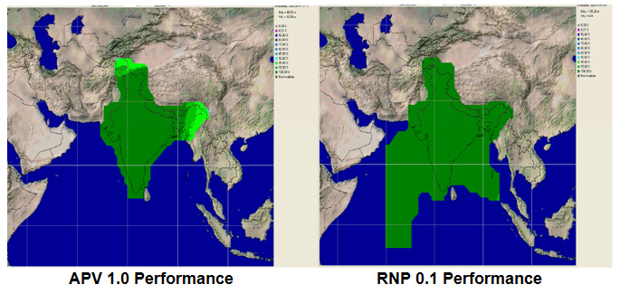
Planned GAGAN service coverage for the two different service levels (RNP0.1 and APV1). GAGAN has been jointly undertaken by the Airport Authority of India and the Indian Space Research Organization, ISRO, to achieve smooth transition to satellite-based navigation and seamless air traffic management across continents. GAGAN is designed to provide improved accuracy, availability and integrity necessary to enable users to rely on GPS for all phases of flight, from en route through approach for all qualified airports within the GAGAN service volume. More precisely it is aimed to provide Non Precision Approach RNP0.1 service levels to the entire Indian Flight Information Region and Precision Approach APV1 service (equivalent to the current EGNOS Service) within a specified service volume within Indian land mass.
Tackling ionospheric interference
The New Delhi IWG took place concurrently with a related meeting, the ICAO’s 4th Ionospheric Study Task Force. This group has been tasked with the objective of developing region-specific models of ionospheric models to compensate for satnav signal interference or loss.
The ionosphere, the electrically sensitive outer shell of Earth’s atmosphere, can be perturbed by solar activity. And because satnav signals pass from space by Earth they can then be disrupted in turn. Equatorial regions see the greatest disturbance, including signal delay or ‘scintillations’ making signals unstable.
The aim is to develop reliable ionospheric models to compensate for these effects, particularly for equatorial SBAS regions, such as India. ESA is contributing with data from its worldwide Monitor network, gathering data to improve future EGNOS performance and potentially support further geographical extension.
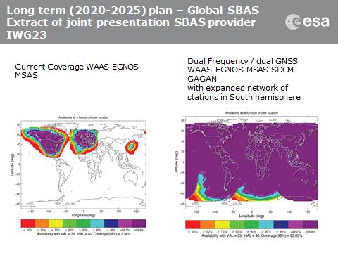
Comparing current worldwide SBAS coverage — based on WAAS, EGNOS and MSAS — to the situation envisaged for 2020–25: near-global coverage based on WAAS, EGNOS, MAAS, SDCM and GAGAN, with an expanded network of stations in the southern hemisphere, based on a common dual-frequency/dual satnav standard being finalized by the SBAS IWG.
The Business section from the January 2014 issue (Download the PDF). Includes: 2014 Receiver Survey Addendum (for the full survey, click here); FAA Selects Six Sites for UAV Research; NovAtel Supplies Reference Receivers for IRNSS Ground Segment; SkyTraq Seeks Crowdfunding for GPS/BeiDou Development Board; Hemisphere GNSS Names Chuck Joseph President and CEO; Honda Joins Google Alliance to Develop GPS Solutions; Garmin Launches New Outdoor Series; Saelig Introduces Low-Cost SMD Antennas; Events
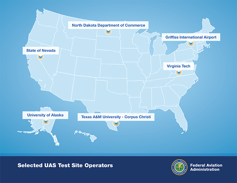
After a rigorous 10-month selection process involving 25 proposals from 24 states, the Federal Aviation Administration announced it has chosen six unmanned aircraft systems (UAS) research and test site operators across the country.
According to the announcement, in selecting the six test site operators, the FAA considered geography, climate, location of ground infrastructure, research needs, airspace use, safety, aviation experience and risk. In totality, these six test applications achieve cross-country geographic and climatic diversity and help the FAA meet its UAS research needs.
A brief description of the six test site operators and the research they will conduct into future UAS use are below:
University of Alaska. The University of Alaska proposal contained a diverse set of test site range locations in seven climatic zones as well as geographic diversity with test site range locations in Hawaii and Oregon. The research plan includes the development of a set of standards for unmanned aircraft categories, state monitoring and navigation. Alaska also plans to work on safety standards for UAS operations.
State of Nevada. Nevada’s project objectives concentrate on UAS standards and operations as well as operator standards and certification requirements. The applicant’s research will also include a concentrated look at how air traffic control procedures will evolve with the introduction of UAS into the civil environment and how these aircraft will be integrated with NextGen. Nevada’s selection contributes to geographic and climatic diversity.
New York’s Griffiss International Airport. Griffiss International plans to work on developing test and evaluation as well as verification and validation processes under FAA safety oversight. The applicant also plans to focus its research on sense and avoid capabilities for UAS and its sites will aid in researching the complexities of integrating UAS into the congested, northeast airspace.
North Dakota Department of Commerce. North Dakota plans to develop UAS airworthiness essential data and validate high reliability link technology. This applicant will also conduct human factors research. North Dakota’s application was the only one to offer a test range in the Temperate (continental) climate zone and included a variety of different airspace which will benefit multiple users.
Texas A&M University – Corpus Christi. Texas A&M plans to develop system safety requirements for UAS vehicles and operations with a goal of protocols and procedures for airworthiness testing. The selection of Texas A&M contributes to geographic and climactic diversity.
Virginia Polytechnic Institute and State University (Virginia Tech). Virginia Tech plans to conduct UAS failure mode testing and identify and evaluate operational and technical risks areas. This proposal includes test site range locations in both Virginia and New Jersey.
Across the six applicants, the FAA is confident that the agency’s research goals of System Safety & Data Gathering, Aircraft Certification, Command & Control Link Issues, Control Station Layout & Certification, Ground & Airborne Sense & Avoid, and Environmental Impacts will be met.
Each test site operator will manage the test site in a way that will give access to parties interested in using the site. The FAA’s role is to ensure each operator sets up a safe testing environment and to provide oversight that guarantees each site operates under strict safety standards.
From the start, the FAA recognized it was important to have requirements ensuring that privacy and civil liberties are protected at the test sites. Among other requirements, test site operators must comply with federal, state, and other laws protecting an individual’s right to privacy, have publicly available privacy policies and a written plan for data use and retention, and conduct an annual review of privacy practices that allows for public comment.
Under the current law, test site operations will continue until at least February 13, 2017.
Explosive growth in the UAV market is the focus of a free GPS World webinar this Thursday. Most on-board navigation systems in UAVs — unmanned aerial vehicles (UAVs) — rely on GNSS or GNSS with inertial aiding.
As military budgets decline, interest in civilian commercial applications is growing rapidly. The FAA recently awarded special type certification to two UAVs for commercial Arctic operations, and the industry is now poised for the opening of the regulation floodgates to address a growing commercial demand.
In Thursday’s webcast, “Unmanned Aircraft Navigation,” participants will hear from industry leaders in GNSS-based navigation for UAVs, in both the military and civilian sectors: they will tell us what they are doing in UAV navigation and where they see this exciting market going.
The webinar will be held Thursday, November 21, 10 a.m. PST / 1 p.m. EST / 6 p.m. GMT. Registration is free.
Guest Speakers
Olivier Casabianca, Business Area Manager, Trimble GNSS OEM
Casabianca works on the Trimble GNSS OEM portfolio which includes both the Trimble and Ashtech receiver module product lines. He joined Trimble in 2011 with the Ashtech acquisition where he was driving the Ashtech GNSS Technology roadmap and OEM portfolio. He has worked in the GNSS industry since 1997 and has held various positions in Engineering (RTK, GNSS Heading and Attitude firmware engineer, program management, engineering manager) and Marketing. He is located in Nantes area of France.
Hal Adams, Chief Operating Officer, Accord Technology
Hal Adams is founder and Managing Director of AvValues LLC which partnered with Accord Software & Systems, Bangalore, India to form Accord Technology LLC of Phoenix, Arizona USA. Adams has more than 35 years of civil and military aerospace and avionics experience in the aerospace industry, including senior leadership positions in general management, product and business strategies, development activities with Northwest Airlines, Lockheed-Martin, Litton Aero Products (now Northrop Grumman), Rockwell Collins Avionics, Thales Avionics and Aviation Communications and Surveillance Systems (ACSS – an L-3 Communications and Thales Joint Venture). As a co-founder of Phoenix Aerospace Consulting Group, Adams’ oversight responsibility was leading the NexNav business area which provided the industry’s first certified GPS WAAS Beta-3 sensors to the commercial aviation marketplace.
Neil Gerein, Defense Product Manager, NovAtel
Neil Gerein joined NovAtel Inc. as a GPS Software Engineer in 2001. Since 2009 he has worked as the Defense Product Manager for NovAtel. He is responsible for the navigation warfare product lines, including the GAJT GPS Anti-Jam antenna and OEM625S SAASM receiver used in unmanned vehicle systems. He holds B.Sc. and M.Sc. degrees in Electrical Engineering from the University of Saskatchewan, where he specialized in digital signal processing. Neil currently serves on the Council of the Institute of Navigation, as well as on the executive of the Alberta regional section of the Institute of Navigation.
Eric Brewer, Senior Systems Engineer, Rockwell Collins
Eric develops and tests guidance, navigation, and control algorithms for unmanned and optionally piloted aircraft. He was a key contributor to Rockwell Collins’ damage tolerance program, which successfully recovered a sub-scale F18 after simulated battle damage ejecting more than 75% of the right wing. As lead systems engineer, Eric spearheaded the successful integration of SAASM RTK on the STUAS program. He received a B.S. in Mechanical Engineering from Penn State in 2008, and an M.S. in Mechanical Engineering specializing in autonomous rotorcraft from Virginia Tech in 2009. When he’s not programming away in MATLAB, Eric enjoys hiking, rock climbing, and testing the damage tolerance capabilities of R/C airplanes and helicopters.
Howard William Loewen, President, MicroPilot Inc.
Howard is the president of MicroPilot Inc. Howard has a degree in Electrical Engineering with an option in Computer Science and a Masters degree in Computer Science both from the University of Waterloo. Howard has been involved in the UAV industry since 1994 when he started MicroPilot. Under Howard’s leadership, MicroPilot was the first to introduce a single board, fully integrated UAV autopilot into the market, the first to introduce ultra lightweight autopilots, the first to introduce a triple redundant UAV autopilot among others. MicroPilot has continued this tradition of leadership with its recent introduction of XTENDERvalidate a requirements management tool designed specifically for UAV system integrators.