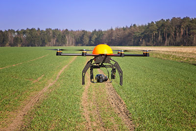
Topcon Positioning Systems has received a national exemption from the Federal Aviation Administration (FAA) that allows for operation of its unmanned aerial system (UAS) in the United States. The exemption covers the operation of the Sirius Basic and Sirius Pro for aerial data collection.
The Sirius Pro and Sirius Basic systems are designed to produce accurate solutions for the automated mapping of a wide range of sites — regardless of terrain — including construction sites, mines and quarries. The UAS are designed for land surveying, transmission line and pipeline inspection, and agricultural operations such as field mapping and livestock management. With the Sirius Pro model, Topcon eliminates the need for ground-control points by combining real-time kinematic (RTK) GNSS solutions with precision timing technology to provide accurate mapping results, Topcon said.
“This exemption is exciting news for the U.S. marketplace,” said Eduardo Falcon, executive vice president and general manager of the Topcon GeoPositioning Solutions Group. “It allows Topcon to be a resource for end-users and provide UAS demonstrations and training. Aerial data collection has a strong impending impact on all the industries we serve, and the possibilities for survey, construction, and agricultural applications are seemingly limitless.
“Building on the success the Sirius models have already seen in the European and Australian markets, this exemption allows Topcon to expand on that momentum in the U.S.,” Falcon said.
With Exelis RangeVue, a high-performance GIS visualization engine provides real-time updates of critical operational elements.
Exelis has launched its first airspace situational awareness tool designed specifically for unmanned aerial system (UAS) operations in the United States. Symphony RangeVue puts real-time Federal Aviation Administration (FAA) surveillance data, flexible background maps and weather information in the hands of UAS operators and test range personnel. The system provides significant improvements to the safety and efficiency of UAS operations, whether on the test range or in the field.
Symphony RangeVue enables UAS operators and test range personnel to have access to both real-time and historical surveillance information via a web-hosted platform, helping to manage mission operations from multiple locations with full visibility of assets. Symphony RangeVue can be used as a command center decision-support and post-event analysis tool, or in the field as a sense-and-avoid addition to UAS ground control stations. Flexible geo-fencing tools alert operators when a UAS approaches airspace boundaries or when other aircraft are in the vicinity.
“For the first time, UAS operators and test range personnel will have the same situational awareness currently available to general aviation pilots through traffic information broadcast services. This capability is available without having to install avionics surveillance equipment on the UAS aircraft,” said Ed Sayadian, vice president of Civil and Aerospace Solutions for Exelis. “Leveraging the FAA’s own surveillance data combined with advanced sense-and-avoid alerting capabilities, Symphony RangeVue will significantly increase the safety of UAS operations.”
Symphony RangeVue combines a high-performance visualization engine with the vast network of Exelis NextGen surveillance data, including all of the FAA’s surveillance systems: automatic dependent surveillance-broadcast; en route radar; terminal radar; airport surface detection equipment-X; airport surface surveillance capability; and wide area multilateration. It also integrates locally deployed surveillance assets to deliver hyperlocal situational awareness.
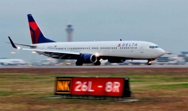
Delta Airlines made a perfect Ground-Based Augmentation System (GBAS) Landing System (GLS) landing at Liberty Newark International Airport on Feb. 18, according to the Federal Aviation Administration’s SatNavNews newsletter.
Delta now joins United Airlines and British Airways as airlines that use the GBAS at Newark.
More GBAS locations around the world are reaching operational status, and airline operations using GBAS are increasing as additional GLS-equipped aircraft are entering service for the various airlines. Boeing has confirmed that many of the customers who have ordered multiple 787s, 747-8s or 737s have publicly stated their intention to use the GLS capability on these aircraft.
More than 1,000 Boeing GLS-equipped aircraft are now in use, and this number is growing by an estimated 25 airplanes per month. This estimate is based upon current production rates — one third of 737s are being equipped with the GLS option. GLS is standard on 787 and 747-8 aircraft.
The list below provides a summary of the airlines using GBAS and the airports where GLS approaches are flown on a regular basis.
U.S. Carriers
Delta Airlines – Houston, Newark
United Airlines – Houston, Newark
Non-U.S. Carriers
Air Berlin – Bremen, Malaga
British Airways – Newark
Cathay Pacific – Houston, Sydney (plans for Newark in the future)
Various Russian airlines (S7, Transaero, Utair, Sakhalin Energy, Gaspromavia Russia). Fifteen GBAS locations in Russia have been approved with each airline using different airports (Domodedovo, Pulkovo, Tyumen, Ostafyevo, Nogliki and others).
The commitment to GBAS development and implementation continues to grow, according to the FAA, with plans to implement GBAS in these additional locations:
The “summary grant” process the Federal Aviation Administration (FAA) used last week to issue 30 Section 333 unmanned aircraft systems (UAS) exemptions is an example of how the agency is using a flexible regulatory approach to accommodate this rapidly evolving technology, according to a news statement from the FAA.
The new approach will speed up Section 333 exemption approvals for many commercial UAS operators, the FAA said. Section 333 is the part of the 2012 FAA reauthorization law that lets the Secretary of Transportation determine if certain low-risk UAS operations can be authorized before finalizing the small UAS proposed rule published in February.
Although the FAA still reviews each Section 333 petition individually, the agency can issue a summary grant when it finds it has already granted a previous exemption similar to the new request. Summary grants are far more efficient because the FAA doesn’t need to repeat the analysis performed for the original exemption on which they are based. Summary grants are a tool the FAA can use in all exemption areas, not just UAS.
The FAA’s experience in reviewing the Section 333 petitions shows they generally fall into two categories: film/television production and aerial data collection. Most exemptions in these categories will likely be handled through the summary grant process. For unique requests, the agency will still publish the petition in the Federal Register for public comment and will conduct a detailed analysis.
The FAA also made two other changes to the Section 333 exemption process last week:
The agency now allows operations under these exemptions by people who hold a recreational or sport pilot certificate. Previously, Section 333 operators were required to have at least a private pilot certificate. The newly added certificates are easier to obtain, and therefore less costly, than a private pilot certificate.
A third-class medical certificate is no longer required. Now, a Section 333 operator only needs a valid driver’s license to satisfy the medical requirement. This change is consistent with the agency’s approach for sport pilot certificate holders, who may fly light sport aircraft with a driver’s license and no FAA medical certificate.
Brian Wynne, president and CEO of the Association for Unmanned Vehicle Systems International (AUVSI), applauded the change. “For months, AUVSI has advocated for a more streamlined process for Section 333 exemptions that will help more industries realize the benefits of UAS technology,” Wynne said. ” The FAA’s new summary grant process is a step in the right direction that cuts through the red tape while making it easier for operators to fly UAS. We applaud the agency for lifting unnecessary restrictions and enabling more commercial uses of the technology in a safe and responsible manner.”
The Federal Aviation Administration has approved 30 more commercial unmanned aircraft systems exemptions, bringing the total number of approved operations to 99, reports AUVSI News. AUVSI is the Association for Unmanned Vehicle Systems International.
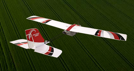
Among those receiving exemptions are the insurance companies USAA and AIG. USAA said in a press release that the exemption “could help speed review of insurance claims from its members following natural disasters.” USAA plans to fly the PrecisionHawk drone.
USAA also filed for an additional FAA exemption in November that will enhance USAA’s ability to use drones in catastrophes. That exemption petition is pending approval, and a decision is expected soon.
Other companies receiving exemptions include senseFly for precision agriculture, and AeroVironment for agriculture, aerial survey and patrol applications.
Jim Williams, manager for the Federal Aviation Administration’s Unmanned Aircraft Systems (UAS) office, will be the keynote speaker at the MAPPS National Surveying, Mapping and Geospatial Conference, scheduled for April 13-16 in Crystal City (Arlington),Va.
Williams will speak at a luncheon on April 14. He’ll address the recently published notice of proposed rulemaking issued by his office in FAA, including regulations and policies that will affect surveying and mapping firms that want to fly unmanned aerial vehicles (UAV) and UAS in the commercial market.
“MAPPS has worked with Mr. Williams and his staff for several years to assure that business and societal benefits of using UAV/UAS for aerial surveying, mapping and imagery are recognized and empowered in FAA policy,” said John Palatiello, MAPPS executive director. “UAV/UAS technology is the future of the mapping, surveying and geospatial profession. It is imperative that geospatial firms have the ability to operate UAV/UAS. Mr. Williams understands this, and his office’s policies have reflected his understanding of our community as an important stakeholder.”
“We’re honored to have Mr. Williams join us at the conference. We look forward to hearing how he sees the future of UAV/UAS and how it will effect the business and professional practice of surveying and mapping,” said Curtis Sumner, National Society of Professional Surveyors (NSPS) executive director. “His addition to the conference strengthens an already outstanding program.”
Full registration for the conference is required for admission to the keynote luncheon.
McMurdo Group, maker of end-to-end search and rescue solutions, has received formal certification from the U.S. Federal Aviation Administration (FAA) and European Aviation Safety Agency (EASA) for its Kannad Integra ARINC 429 Navigation Interface.
Based on the ARINC 429 GPS communications standard for most commercial aircraft, the interface, when used with the Kannad Integra Emergency Locator Transmitter (ELT), provides dual GPS redundancy that can result in aircraft being found much faster compared to standard ELTs in event of an emergency. The solution has already been selected by aircraft manufacturers including Pilatus, Embraer and Airbus Helicopters.
Traditional ELTs rely on an aircraft’s external antenna and GPS equipment, which is subject to failure in the event of an emergency. The Kannad Integra ELT, however, can operate independently of the aircraft to provide key positioning data through its built-in internal antenna and embedded GPS receiver. The Integra ARINC 429 navigation interface stores the latest known position of the aircraft based on the aircraft navigation system data. This data is then used by the built-in Integra GPS for better location accuracy and a higher chance of rescue.
The Kannad Integra ELT and Integra ARINC 429 Navigation Interface are suitable for commercial aircraft, helicopters, business jets and airlines. Once activated, the Integra ELT transmits a distress signal to alert international rescue services to the emergency location via the global Cospas-Sarsat Search and Rescue satellite system, which has helped to save more than 37,000 lives since 1982.
“McMurdo’s Kannad products have been chosen by the world’s leading aircraft manufacturers and airlines for their quality, reliability and innovation,” said Christian Belleux, head of McMurdo’s Kannad Aviation Business Unit. “This new ARINC 429 interface is yet another example of how we are helping to shape the present and the future of aviation safety.”
The Federal Aviation Administration has established an interim policy to speed up airspace authorizations for certain commercial unmanned aircraft operators who obtain Section 333 exemptions. The new policy helps bridge the gap between the past process, which evaluated every UAS operation individually, and future operations after the FAA publishes a final version of the proposed small UAS rule.
Under the new policy, the FAA will grant a Certificate of Waiver or Authorization (COA) for flights at or below 200 feet to any UAS operator with a Section 333 exemption for aircraft that weigh less than 55 pounds, operate during daytime Visual Flight Rules (VFR) conditions, operate within visual line of sight (VLOS) of the pilots, and stay certain distances away from airports or heliports:
5 nautical miles (NM) from an airport having an operational control tower; or
3 NM from an airport with a published instrument flight procedure, but not an operational tower; or
2 NM from an airport without a published instrument flight procedure or an operational tower; or
2 NM from a heliport with a published instrument flight procedure
The blanket 200-foot COA allows flights anywhere in the country except restricted airspace and other areas, such as major cities, where the FAA prohibits UAS operations. Previously, an operator had to apply for and receive a COA for a particular block of airspace, a process that can take 60 days. The agency expects the new policy will allow companies and individuals who want to use UAS within these limitations to start flying much more quickly than before.
Section 333 exemption holders will automatically receive a blanket 200-foot COA. For new exemption holders, the FAA will issue a COA at the time the exemption is approved. Anyone who wants to fly outside the blanket parameters must obtain a separate COA specific to the airspace required for that operation.
More information on the UAS exemption process is available on the FAA’s UAS page.
The Federal Aviation Administration has issued an experimental airworthiness certificate to an Amazon Logistics, Inc. unmanned aircraft (UAS) design that Amazon will use for research and development and crew training. Amazon has said it wants to use drones for delivering packages to customers.
The FAA typically issues experimental certificates to manufacturers and technology developers to operate a UAS that does not have a type certificate.
Under the provisions of the certificate, all flight operations must be conducted at 400 feet or below during daylight hours in visual meteorological conditions. The UAS must always remain within visual line-of-sight of the pilot and observer. The pilot actually flying the aircraft must have at least a private pilot’s certificate and current medical certification.
The certificate also requires Amazon to provide monthly data to the FAA. The company must report the number of flights conducted, pilot duty time per flight, unusual hardware or software malfunctions, any deviations from air traffic controllers’ instructions, and any unintended loss of communication links. The FAA includes these reporting requirements in all UAS experimental airworthiness certificates.
That means you can’t fly drones if it’s related to business, no matter if you charge a fee or not. But, you can fly drones in the United States as a “hobbyist” as long as you adhere to certain rules (such as flying lower than 400 feet above the ground).
In a new twist, the FAA has cracked down on at least one person who posted a drone video on YouTube because YouTube generates revenue, reports the website Motherboard. Even though it appears the drone was being flown by a hobbyist for recreational purposes, it smells to the FAA like a commercial use of drone. Even though the hobbyist isn’t generating revenue from it, Google is.
Jason Hanes’ YouTube channel.
While it appears the U.S. drone community is going nuts using drones for all kinds of non-commercial and commercial purposes, despite the FAA rules, it appears there are too many violators for the FAA to chase after since enforcement notices sent by the FAA have been few and far between. In this case, safety concerns may have been the prompt. The FAA says it’s now looking further into how its safety inspectors send letters like this. Read more about the case at the Motherboard website.
Geospatial Data Interest Crosses Political Party Lines
Senator’s Mark Warner (D-Va.) and Orrin Hatch (R-Utah) introduced the Geospatial Reform Act, targeted at leveraging geospatial data acquired by the U.S. federal government. This bill argues that the federal government is the largest purchaser of geospatial data, yet agencies aren’t required to report details of geospatial data purchased. The bill aims to change that.
“Geospatial data has endless possibilities for transforming both the private and public sectors — from helping local governments develop emergency preparedness plans to fueling the creation of apps that let you find parking spots, restaurants, and even homes for sale based on where you’re standing,” said Sen. Warner. “The federal government is the largest purchaser of geospatial data but some very basic questions about how and where agencies are already investing in this data can’t be answered. Our bill would bring transparency and accountability to the collection of this data and ensure that taxpayer dollars are not being wasted on duplicative efforts.”
In what DigitalGlobe claims is a world’s first, the company began offering commercial 30-cm satellite imagery via its WorldView-3 satellite, which was launched August 13, 2014. DigitalGlobe announced that the imagery is available worldwide (with some restrictions). As part of its press release, DigitalGlobe offered the following quote from PhotoSat, a consumer of imagery.
“DigitalGlobe’s WorldView-3 satellite data is the highest quality satellite photo data that PhotoSat has ever processed,” said Gerry Mitchell, President of PhotoSat, a leading satellite elevation mapping provider for energy, mining, and engineering firms. “In one test, an elevation mapping grid extracted from stereo WorldView-3 satellite photos matched a highly accurate LiDAR elevation grid to better than 15 cm in elevation. This result takes satellite elevation mapping into the engineering design and construction markets and directly competes with LiDAR and high resolution air photo mapping for applications like flood plain monitoring.”
According to DigitalGlobe, WorldView-3 is the first and only commercial imaging satellite capable of collecting imagery with 30-cm ground sample distance, and claims it is five times the detail of the company’s nearest competitor. See a sample by clicking here.
Satellite imagery is approaching aerial photogrammetry quality. I recall Lawrie Jordan, founder of ERDAS (sold to Leica) and now director of imagery at Esri, saying that eventually every square inch of the earth will be imaged constantly by satellite.
Esri and Drone Data Up until now, you haven’t heard the words “Esri” and “drone” mentioned in the same sentence very often. Last week at the Esri Developer Summit in Palm Springs, Esri provided a live map-creation demo using a small quadcopter.
Look for a follow-up article, data example and possibly a video of the event.
The public has until April 24 to comment on a framework of regulations proposed by the Federal Aviation Administration (FAA) in February. The regulations would allow routine use of certain small unmanned aircraft systems (UAS) in today’s aviation system, while maintaining flexibility to accommodate future technological innovations, the agency said.
The FAA proposal offers safety rules for small UAS (under 55 pounds) conducting non-recreational operations. The rule would limit flights to daylight and visual-line-of-sight operations. It also addresses height restrictions, operator certification, optional use of a visual observer, aircraft registration and marking, and operational limits.
The new rules would not apply to model aircraft. However, model aircraft operators must continue to satisfy all of the criteria specified in Sec. 336 of Public Law 112-95, including the stipulation that they be operated only for hobby or recreational purposes.
The public will be able to comment on the Small UAS Notice of Proposed Rulemaking for 60 days from the date of publication in the Federal Register. The proposed regulation was published for public comment on February 23, and comments will be accepted through April 24.