MAPPS has come out in support of the proposed framework of regulations that the Federal Aviation Administration (FAA) has proposed for commercial UAV use. The FAA’s rules would allow routine use of certain small unmanned aircraft systems (UAS) for commercial purposes.
MAPPS Executive Director John Palatiello issued the following statement about the Notice of Proposed Rulemaking (NPRM) issued by the FAA concerning operation and certification of Small Unmanned Aircraft Systems (UAS):
“The proposed rules issued by the FAA for the commercial use of small unmanned aircraft systems (UAS) will provide considerable potential business applications for MAPPS member firms in the aerial survey profession. According to the FAA, the following are examples of possible small UAS operations that could be conducted under the proposed regulations: crop monitoring/inspection; research and development; educational/academic uses; power-line/pipeline inspection in hilly or mountainous terrain; antenna inspections; aiding rescue operations such as locating snow avalanche victims; bridge inspections; aerial photography; and wildlife nesting area evaluations.
“In the past, MAPPS has worked closely with the FAA to enable the commercial use of small UAS (which, as defined by statute, is an unmanned aircraft weighing less than 55 pounds) for aerial survey purposes through various mechanisms, such as special airworthiness certificates, exemptions, and certificates of waiver or authorization (COA). MAPPS will continue to support the proposed federal regulations, which will provide for the next phase of integrating small UAS into the national airspace system.”
MAPPS will provide comments to the FAA concerning the proposed rules, and the association will continue to educate its member firms about operational limitations of small UAS in order to maintain the safety of the national airspace system and ensure that they do not pose a threat to national security.
As a member of a Aviation Rulemaking Committee (ARC) working group advising the FAA on Beyond Visual Line of Sight (BVLOS) regulations, Palatiello added, “Prompt implementation of the small, line-of-sight UAS rules will help strike the necessary balance between aviation safety and business development, but the next set of rules, governing beyond visual line of sight, need to be developed and implemented as soon as possible as well.”
“MAPPS has made the case that aerial geospatial data acquisition using UAS provides significant societal benefit and is NOT a threat to individual citizen privacy, and should be permitted to operate within a reasonable regulatory framework,” MAPPS Aviation Counsel Gregory S. Winton said. “It contributes to E911 emergency response and police dispatching systems, precision agriculture, environmental protection, emergency ‘blue tarp’ surveys to support hurricane response, engineering, transportation and infrastructure, electoral district maps, and many other applications. Geospatial data enables the delivery of critical government services and valuable business applications that citizens are demanding. The proposed FAA rule will enable this profession, which has an exemplary safety record and vast experience in manned aerial operations, to use of UAS safely, effectively and economically.”
After much criticism in the mainstream and technology media about the commercial use of UAS (unmanned aerial systems), the Federal Aviation Administration (FAA) has been remarkably proactive in integrating the commercial use of UAS in the United States National Airspace System (NAS) the past two months. Just last summer, media like the Washington Post, fueled by a government audit, were reporting that the FAA will miss the September 2015 deadline, which is spelled out in the FAA Reauthorization and Reform Act of 2012, to integrate commercial UAS usage into the NAS.
By proactive, I mean the rate at which the FAA is issuing UAS exemptions for commercial use. Two weeks ago, the FAA issued eight more commercial UAS exemptions, bringing the total to 24 since June 2014, with the vast majority of those being issued in the last two months. The latest exemptions issued were for aerial mapping, motion picture and television production, and bridge inspection. You can view the entire list of exemptions and the intended applications here. All of the exemptions have more than 30 conditions and limitations the operator must follow, of which a FAA private pilot (or better) certificate and a FAA third-class medical certificate is required, as well as a second person, the Visual Observer (VO). That’s fine. There’s nothing new on that front since I last reported on this.
However, earlier this week, the FAA issued an NPRM (Notice of Proposed Rule Making) for commercial operations of “small” UAS, with surprisingly lightweight conditions compared to the exemptions granted thus far. Following are the key points of the NPRM:
Pilot must be 17 years of age or older.
Pass an FAA-approved aeronautical knowledge test and retest every two years.
Obtain an unmanned aircraft operator certificate with a small UAS rating.
Obtain an FAA Class II airman medical certificate.
Be vetted by the Transportation Security Agency (TSA).
Maintain visual line of sight without aids (except corrective lenses).
Not operate over any person who is not part of the mission.
Maximum UAS weight is 55 pounds.
Maximum airspeed of 100 mph.
Maximum altitude of 500 feet above ground level.
Minimum weather visibility of three miles.
Yield right-of-way to other manned and unmanned aircraft.
Contact air traffic control or airport operator when flying within five miles of an airport.
These conditions are certainly lighter than the conditions imposed on the exemptions issued thus far. However, instead of requiring an FAA private pilot certificate, the FAA proposes creating a new type of certificate named an “unmanned aircraft operator certificate.” Digging into the documentation, the new “small UAS pilot certificate” consists generally of the following:
At least 17 years of age, although the FAA seems open to reducing it to 16 years of age.
Read, write, speak English (with exceptions).
Pass an initial aeronautical knowledge test, which tests the applicant’s understanding of FAA regulations, airspace, flight restrictions, collision avoidance, weather/meteorology, weight/balance calculations, emergency response, aeronautical decision-making, airport operations, and drug/alcohol impairment.
Demonstrate flight proficiency and aeronautical experience. The FAA is asking for suggestions on these two.
For a summary description of the proposed Small UAS Limitations and Certifications, click here.
For a detailed description of the proposed requirements for the FAA small UAS pilot certificate, click here.
The FAA Class II Airman medical certificate requirement is somewhat surprising because it’s more stringent than the Class III medical certificate required in the exemptions issued thus far. Perhaps the FAA is rethinking this because of the line-0f-sight requirement that puts a premium on sharp vision for UAS pilots. Class II requires distance vision of 20/20 in each eye separately while Class III only requires distance vision of 20/40 in each eye separately. Click here to see the requirements for Class I, II and III medical certificates. To give you some idea, I had an FAA Class III medical exam completed last month. It took about an hour. Although I have an FAA private pilot certificate, one is not needed to obtain an FAA medical certificate.
FAA Class III Medical Certificate
Perhaps a bigger challenge than passing the FAA medical exam, which wasn’t difficult, was finding a certified FAA medical examiner near you. You can search for an examiner near you by clicking here.
So, it seems the FAA is making progress, and we should give them credit for that. But, we are still very early in the process, and as the mainstream and other media predict, the FAA will likely burn through the September 2015 deadline well into next year, albeit chipping away and issuing exemptions on a regular basis as they have been for the past two months. You can bet that exemption applications are piling up. To view the growing list of exemption applications, click here. In reading the FAA Reauthorization and Reform Act of 2012, it states “The FAA is required to initiate a Notice of Proposed Rulemaking (NPRM) for site integration of UAS within 18 months of the date of enactment of the integration plan.” Hmmm, 18 months from now = October 2016, and this NPRM is for small UAS only. Stay tuned….
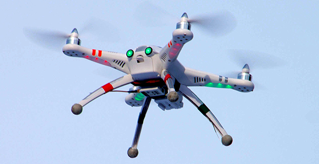
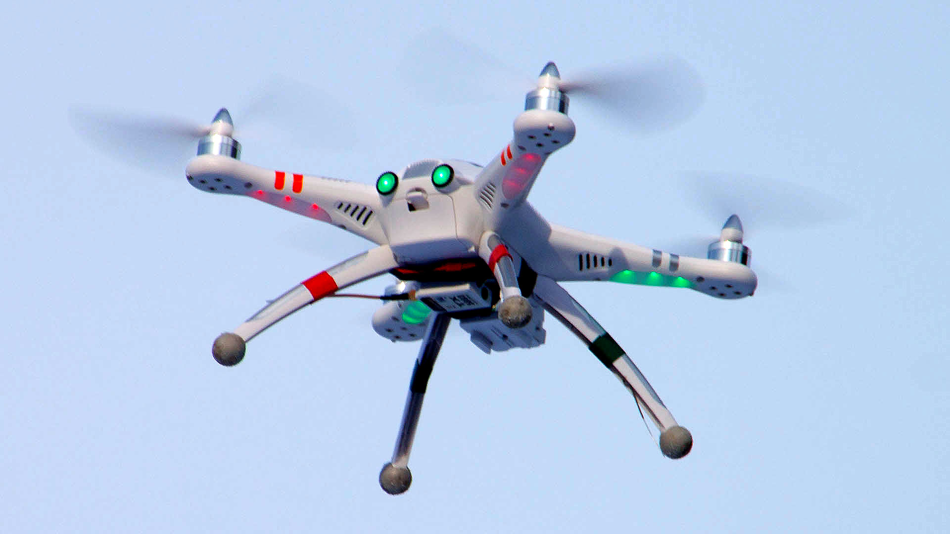
A Walkera QR X350 quadcopter. (Photo credit: Wikimedia Commons).
The Federal Aviation Administration has proposed a framework of regulations that would allow routine use of certain small unmanned aircraft systems (UAS) in today’s aviation system for commercial purposes.
“We have tried to be flexible in writing these rules,” said FAA Administrator Michael Huerta in a statement. “We want to maintain today’s outstanding level of aviation safety without placing an undue regulatory burden on an emerging industry.”
The FAA proposal offers safety rules for UAS under 55 pounds conducting “non-recreational” operations. The rule would limit flights to daylight and visual line-of-sight operations. It also addresses height restrictions, operator certification, optional use of a visual observer, aircraft registration and marking, and operational limits.
The proposed rules also includes extensive discussion of the possibility of an additional, more flexible framework for “micro” UAS under 4.4 pounds. The FAA is asking the public to comment on this possible classification to determine whether it should include this option as part of a final rule. The FAA is also asking for comment about how the agency can further leverage the UAS test site program and an upcoming UAS Center of Excellence to further spur innovation at “innovation zones.”
The public will be able to comment on the proposed regulation for 60 days from the date of publication in the Federal Register. The FAA also intends to hold public meetings to discuss innovation and opportunities at the test sites and Center of Excellence. These meetings will be announced in a future Federal Register notice.
“Technology is advancing at an unprecedented pace, and this milestone allows federal regulations and the use of our national airspace to evolve to safely accommodate innovation,” said Transportation Secretary Anthony Foxx.
The proposed rule would require an operator to maintain visual line of sight of a small UAS. The rule would allow, but not require, an operator to work with a visual observer who would maintain constant visual contact with the aircraft. The operator would still need to be able to see the UAS with unaided vision (except for glasses). The FAA is asking for comments on whether the rules should permit operations beyond line of sight, and if so, what the appropriate limits should be.
Under the proposed rule, the person actually flying a small UAS would be an “operator.” An operator would have to be at least 17 years old, pass an aeronautical knowledge test and obtain an FAA UAS operator certificate. To maintain certification, the operator would have to pass the FAA knowledge tests every 24 months. A small UAS operator would not need any further private pilot certifications (such as a private pilot license or medical rating).
The new rule also proposes operating limitations designed to minimize risks to other aircraft and people and property on the ground:
A small UAS operator must always see and avoid manned aircraft. If there is a risk of collision, the UAS operator must be the first to maneuver away.
The operator must discontinue the flight when continuing would pose a hazard to other aircraft, people or property.
A small UAS operator must assess weather conditions, airspace restrictions and the location of people to lessen risks if he or she loses control of the UAS.
A small UAS may not fly over people, except those directly involved with the flight.
Flights should be limited to 500 feet altitude and no faster than 100 mph.
Operators must stay out of airport flight paths and restricted airspace areas, and obey any FAA Temporary Flight Restrictions (TFRs).
The proposed rule maintains the existing prohibition against operating in a careless or reckless manner. It also would bar an operator from allowing any object to be dropped from the UAS.
Operators would be responsible for ensuring an aircraft is safe before flying, but the FAA is not proposing that small UAS comply with current agency airworthiness standards or aircraft certification. For example, an operator would have to perform a preflight inspection that includes checking the communications link between the control station and the UAS. Small UAS with FAA-certificated components also could be subject to agency airworthiness directives.
The new rules would not apply to model aircraft. However, model aircraft operators must continue to satisfy all of the criteria specified in Sec. 336 of Public Law 112-95, including the stipulation that they be operated only for hobby or recreational purposes. Generally speaking, the new rules would not apply to government aircraft operations, because we expect that these government operations will typically continue to actively operate under the Certificate of Waiver or Authorization (COA) process unless the operator opts to comply with and fly under the new small UAS regulations.
In addition to this proposal, earlier today, the White House issued a Presidential Memorandum concerning transparency, accountability, and privacy, civil rights, and civil liberties protections for the Federal Government’s use of UAS in the national airspace system, which directs the initiation of a multi-stakeholder engagement process to develop a framework for privacy, accountability, and transparency issues concerning commercial and private UAS use.
The current unmanned aircraft rules remain in place until the FAA implements a final new rule. The FAA encourages new operators to visit www.knowbeforeyoufly.org.
Aerial photographer Raphael Pirker has settled the civil penalty proceeding brought by the U.S. Federal Aviation Administration in 2013 concerning his flight of a styrofoam Zephyr II model aircraft (or “drone”) at the University of Virginia at Charlottesville in October 2011.
The $1,100 settlement “does not constitute an admission of any of the allegations in the case or an admission of any regulatory violation,” Pinker’s attorney Brendan Schulman said in a statement.
On December 1, the National Transportation Safety Board ruled in favor of the FAA, when the FAA appealed a decision by an NTSB Administrative Law Judge in Huerta v. Pirker after the judge dismissed the FAA’s order requiring Pirker to pay a civil penalty of $10,000 for operating an unmanned aircraft in a careless or reckless manner at the University of Virginia in October 2011.
Pinker was said to have been hired to supply aerial photographs and video of the university campus and medical center. He had argued that his aircraft, which was described as an UAS, was in fact a model aircraft.
Schulman wrote: “We are pleased that the case ignited an important international conversation about the civilian use of drones, the appropriate level of governmental regulation concerning this new technology, and even spurred the regulators to open new paths to the approval of certain commercial drone operations.
“The decision to settle the case was not an easy one, but the length of time that would be needed to pursue further proceedings and appeals, and the FAA’s new reliance on a statute that post-dates Raphael’s flight, have diminished the utility of the case to assist the commercial drone industry in its regulatory struggle.”
The Federal Aviation Administration (FAA) declared today that Super Bowl XLIX will be a “No Drone Zone.”
“Many familiar sounds are associated with the Super Bowl: Cheering fans. Referee whistles. The spectacular halftime show. Booming fireworks,” the FAA wrote. “But one sound you shouldn’t hear is the whirring of an unmanned aircraft overhead. The Super Bowl is strictly a ‘No Drone Zone’.” The restriction applies to University of Phoenix Stadium in Glendale, Arizona, during the game.
The FAA bars unauthorized aircraft — including drones — from flying over or near NFL regular- and post-season football games. The same restriction applies to NCAA college games in stadiums seating 30,000 or more fans, Major League Baseball games and many NASCAR events. Other unauthorized aircraft include airplanes, hang gliders, hot air balloons, and model rockets.
The FAA Notice to Airmen makes it crystal clear that anyone violating the rules may be “intercepted, detained and interviewed” by law enforcement or security personnel. Besides possibly landing a violator in jail, flying an unmanned aircraft over a crowded stadium could result in an FAA civil penalty for “careless and reckless” operation of an aircraft.
The agency also produced a YouTube video with the same message.
The quadcopter that crashed on the White House lawn. Photo: U.S. Secret Service
A government employee who crashed his friend’s drone on the White House lawn was apparently drinking while droning.
The employee, who works for the National Geospatial-Intelligence Agency (NGA), was questioned Jan. 26 by the Secret Service as the operator of the drone involved in Monday’s incident at the White House. On Monday at 3 a.m., the drone quadcopter crashed on the White House lawn.
The employee contacted authorities, according to the NGA. The employee was off duty and is not involved in work related to drones or unmanned aerial vehicles in any capacity at NGA, the agency said in a statement.
“Even though the employee was using a personal item while off duty, the agency takes the incident very seriously and remains committed to promoting public trust and transparency,” the statement reads.
The Secret Service is investigating the incident.
Firmware to Force No-Fly Zone Compliance
The drone is a Phantom made by Chinese company DJI. The company plans to roll out firmware within days to prevent any of its drones from flying over the D.C. area, in accordance with Federal Aviation Authority guidelines. This will help hobbyists who aren’t aware of or unable to comply with “no-fly zones,” such as the one that covers most of the D.C. area.
Once updated, the DJI drones will not be able to take off from or fly into the nation’s capital or a 15-mile radius around it. GPS technology in the drones will be able to identify the no-fly zone, warn the operator and then stop at the no-fly zone’s border. DJI’s flight software currently prevents flights within a radius of major airports.
“With the unmanned aerial systems community growing on a daily basis, we feel it is important to provide pilots additional tools to help them fly safely and responsibly,” said Michael Perry, DJI’s company spokesperson. “We will continue cooperating with regulators and lawmakers to ensure the skies stay safe and open for innovation.”
The mandatory firmware update is for the Phantom 2, Phantom 2 Vision, and Phantom 2 Vision+ models. It adds a No-Fly Zone centered on downtown Washington, D.C., extending for a 15.5-mile radius in all directions. Phantom pilots in this area will not be able to take off from or fly into this airspace.
“The restriction is part of a planned extension of DJI’s No Fly Zone system that prohibits flight near airports and other locations where flight is restricted by local authorities,” DJI said. “These extended no fly zones will include over 10,000 airports registered with the International Air Transport Association (IATA) and will expand no fly zones to ensure they cover the runways at major international airports.
“DJI is also continuing to update its no-fly zone list in compliance with local regulations to include additional sensitive locations and to prevent flight across national borders. These new safety features will be released across DJI’s flying platforms in the near future.”
CNN has entered into a Cooperative Research and Development Agreement (CRDA) with the Federal Aviation Administration to advance efforts to integrate unmanned aerial vehicles (UAVs) into newsgathering and reporting.
The cooperation arrangement will integrate efforts from CNN’s existing research partnership with the Georgia Tech Research Institute (GTRI). Coordination between and among CNN, GTRI and the FAA has already begun. The FAA will use data collected from this initiative to formulate a framework for various types of UAVs to be safely integrated into newsgathering operations.
“Our aim is to get beyond hobby-grade equipment and to establish what options are available and workable to produce high quality video journalism using various types of UAVs and camera setups,” said CNN Senior Vice President David Vigilante. “Our hope is that these efforts contribute to the development of a vibrant ecosystem where operators of various types and sizes can safely operate in the US airspace.”
“Unmanned aircraft offer news organizations significant opportunities,” said FAA Administrator Michael Huerta. “We hope this agreement with CNN and the work we are doing with other news organizations and associations will help safely integrate unmanned newsgathering technology and operating procedures into the National Airspace System.”
The eBee Sensefly UAV. Photo: Advanced Aviation Solutions
The Federal Aviation Administration (FAA) today granted two more regulatory exemptions for unmanned aircraft systems (UAS) operations for commercial use.
The two companies are Advanced Aviation Solutions of Spokane, Wash., and Tierra Antiqua Reality of Tuscon, Ariz. Advanced Aviation Solutions plans to fly an eBee senseFly UAV Ag system carrying a georeferenced still camera to conduct photogrammetry and crop scouting in order to perform precision agriculture.
The eBee Ag system consists of a 1.5-pound battery-powered aircraft, a personal computer-based ground control station, and associated communications equipment. The UAV is a fixed-wing aircraft with a wingspan of about 3 feet and 2 feet in overall length, which can operate at a maximum speed of about 50 knots.
Tierra Antiqua Reality plans to operate a Phantom 2 Vision+ UAS, which is comprised of an unmanned aircraft and a transportable ground station. The company plans to attach a small ultra-6 lightweight GoPro 3+ camera to the Phantom and operate it over various areas near Tucson to enhance academic community awareness and augment real estate listing videos.
The Phantom is a 3-pound quadcopter with a maximum airspeed of 30 knots.
HEXO+, an autonomous flying camera system, by Squadrone Systems will exhibit at CES 2015.
An Unmanned Systems Marketplace debuts this year at the annual International Consumer Electronics Show (CES), being held this week in Las Vegas. The marketplace highlights the burgeoning technology in drones, unmanned aerial vehicles (UAVs), and other unmanned systems controlled by onboard computers or remotely from the ground.
Also, a session on drones will focus on safety and privacy of commercial UAV use.
The Unmanned Systems Marketplace is at CES Tech East, in the Las Vegas Convention and World Trade Center (LVCC), South Hall 2. Tech East includes the LVCC, the Westgate Las Vegas , and Renaissance Las Vegas. Exhibitors at the marketplace include AirDog, Squadrone, Trace, DJI, iRobot, Trace, Torquing Group DBA ZANO, Ecovacs, EHang, Autel, Pelican Products, and other brands.
According to the CES description of the marketplace, “Drones, UAVs and other unmanned systems have taken off as a unique tool for everyday life, regardless of whether flight is controlled by onboard computers or remotely from the ground. Unmanned systems have revolutionized the way we capture, monitor and assist our world. They provide aerial coverage for sports, travel and real estate; enhance search and rescue, law enforcement and disaster relief; and so much more. Experience the variations in design and functionality of this technology with these current exhibitors in the all-new Unmanned Systems Marketplace.”
The session description reads, “The use of unmanned aerial vehicles (a.k.a. drones) for mapping, surveillance, newsgathering, filmmaking, and recreation is on the rise. Drone experts explore commercial and consumer market opportunities — including using drones to deliver packages — and address issues about safety and privacy.”
By Ugo Celestino, European Commission, Antonella Di Fazio, Telespazio SpA, Vicente José Giner Herrera, Ineco, Patrizio Vanni, ENAV SpA, and Francisco Javier Deblas, ESSP.
This article describes a live demonstration of an aviation application in Tunisia, to help the local aviation community in validating the use of the European Geostationary Navigation Overlay Service (EGNOS) to guide airplanes during landing operations. This activity constitutes the first complete experience of EGNOS Safety of Life (SoL) service for aviation approaches outside Europe. We present here the obtained results that are useful not only for Tunisia, but as a valuable case study for other countries outside Europe interested in using EGNOS in aviation.
EGNOS, operational since 2009, has a European regional coverage that could be quite easily extended to areas adjacent to European Union through the deployment of limited additional ground infrastructure elements, but sharing the same existing space segment and leveraging the other core ground infrastructure.
The European Commission has put in place a series of actions since 2006 to support the EGNOS service extension in neighbouring areas. The MEDiterranean follow-Up for EGNOS Adoption (MEDUSA) is an on-going European initiative related to EGNOS extension in the Euromed region, including North African and Middle East countries around the Mediterranean basin: Algeria, Egypt, Israel, Jordan, Lebanon, Libya, Morocco, Palestine, Syria, and Tunisia. MEDUSA runs a program of technical assistance action in these Euromed countries, in order to prepare them for an optimal adoption and exploitation of European GNSS services in their priority market segments.
The Mediterranean Extension of EGNOS
EGNOS is Europe’s first venture into satellite navigation and paves the way for Galileo, Europe’s independent global satellite navigation system currently under deployment.
EGNOS is a satellite-based augmentation system (SBAS), whose signal is compliant to the international SBAS interoperability standards: standards – MOPS (Minimum Operational Performance Standards) and ICAO SARPs (International Civil Aviation Organization Standard and Recommended Practices). In its current version (V2) it augments the open public service offered by the American Global Positioning System (GPS), by providing correction data that enables to improve GPS position accuracy, and provides integrity information about the GPS system (integrity information is fundamental for aeronautical applications like approaches). EGNOS is interoperable with the other equivalent regional systems. Today other SBASs are the U.S Wide Area Augmentation System (WAAS), the Japanese Multi-functional Satellite Augmentation System (MSAS), the Indian GPS Aided Geo Augmented Navigation (GAGAN) and the Russian System for Differential Correction and Monitoring (SDCM). The future version (V3) of EGNOS will augment Galileo signal as well.
Today EGNOS is operational, and available for use in aviation since 2011, giving opportunities for users to have more accurate and reliable positioning for enhancing existing applications, developing new applications and particularly the safety critical ones. Already more than 150 landing procedures are operational across Europe (some of them also in countries out of the European Union, such as Switzerland, Norway, Guernsey), with many others under development to reach 100 percent Approaches with Vertical Guidance (APV) coverage in the European instrumental runways as per ICAO recommendation.
EGNOS provides three services:
EGNOS Open Service (OS), launched in 2009, is delivered free of charge. It is open for use to anyone with an EGNOS-enabled receiver. This can be any receiver compatible with satellite-based augmentation systems. Being based on GPS, the EGNOS signal does not require major changes for receivers. Today, many mass market receivers available on the market are also EGNOS enabled. EGNOS OS is particularly suitable for mass market and some applications like surveying.
EGNOS Safety-of-life Service (SoL) is authorized for European civil aviation and operational since March 2011. EGNOS SoL delivers the integrity message providing the verification of the GPS system and timely warnings (within six seconds), when the system or its data should not be used for navigation. Since integrity relates to the trust that can be placed in the correctness of the location information supplied by GPS, thanks to this feature EGNOS is able to meet the demands of safety-critical applications in sectors such as aviation.
EGNOS Data Access Service (EDAS) launched in 2012, delivers a terrestrial commercial data service. It consists of a server that gets the data directly from EGNOS system and disseminates it via terrestrial networks in real time, within guaranteed maximum delay, security and performance. EDAS is particularly suitable for professional applications. It provides EGNOS raw data and corrections enabling software solutions that implement products and value added services built on them.
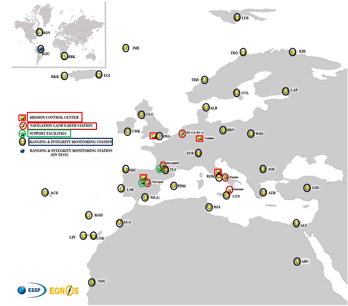
EGNOS infrastructure consists of three geostationary satellites over Europe and a network of ground stations (Ranging and Integrity Monitoring Station – RIMS) located to provide services whose coverage includes southern Europe, North Africa and some Middle East countries.
The EGNOS RIMS network supports a flexible network geometry that gradually adapts to service coverage requirements evolution. From the originally envisaged coverage over European Union’s countries, the EGNOS RIMS network is being expanded over Europe’s neighbouring areas, thus increasing the number of beneficiary countries. EGNOS SoL service is highly sought by several non-EU countries for the benefits it can bring to their civil aviation, in providing a solution to comply with ICAO requirements for Performance Based Navigation (PBN).
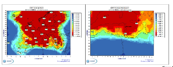
The present layout of the EGNOS RIMS network is presented in Figure 1.
Figure 1. EGNOS ground segment.
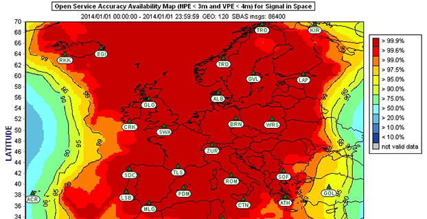
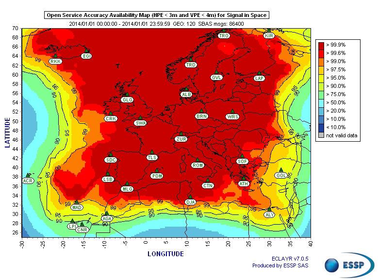
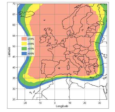
Figures 2 and 3 show respectively today’s coverage of EGNOS OS availability (source: European Satellite Services Provider, the service provider of EGNOS) and the APV-I availability performance commitment provided by EGNOS SoL (source: EGNOS Safety of Life Service Definition Document, EGN-SDD SoL, V2.0, European Commission, 2013), obtained relying on the above presented ground segment.
Figure 2. EGNOS OS Availability.
EGNOS OS Availability. The Figure 2 map is obtained by projecting the error at pseudorange level into the position domain. The computed error assumes that the GPS satellites used are those with an elevation angle above the local horizon (with a mask angle of 5º) and does not consider any possible factor depending on local characteristics that could produce different results (optimistic or pessimistic) with respect to the results computed using real receivers located in the considered areas. Moreover, it represents an estimation of EGNOS OS availability during a very limited period of time being an estimation, thus it does not imply any commitment or reference for the performances which can be obtained during different periods.
Figure 3. EGNOS APV-I Availability.
Other initiatives for a further extension in North Africa and Middle East are already being developed, under the umbrella of the Euromed GNSS programme. In parallel with the infrastructure deployment, the Euromed GNSS programme also includes actions to support the introduction and exploitation of EGNOS services. The first stage was completed in the frame of the Euromed GNSS I/MEdiTerranean Introduction of GNSS Services (METIS) project in the period 2006-2009, the second stage is presently running in the frame of the Euromed GNSS II/MEDUSA project. Further initiatives are being planned for 2015 and beyond.
EGNOS Use in Aviation
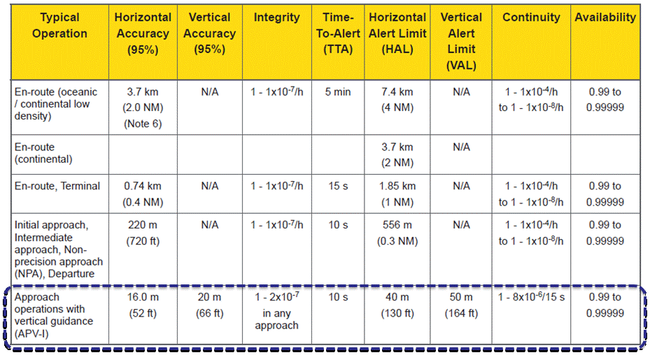
EGNOS was initially designed and developed to be used in aviation, similarly to the U.S. Federal Aviation Administration WAAS, to support different types of aviation applications and, in particular, to meet the performance requirements set by the International Civil Aviation Organization (Annex 10) for the implementation of APV-I, which enable the implementation of LPV final approaches, as reported in Table 1.
Table 1. ICAO Operational Requirements.
EGNOS is one of the GNSS elements recognised by ICAO (Annex 10) as a radionavigation aid. It is an important element of a global SBAS systems mosaic, that started with the American system WAAS in 2003, and that is gradually completed by other more recent SBAS: EGNOS itself, MSAS (Japan), GAGAN (India), SDCM (Russia), and some countries like Australia and South Korea that have launched feasibility studies to develop their own SBAS.
It is expected that, in a not too far future, most parts of the world will profit from SBAS services, following the current coverage extension plans and SBAS system evolutions. The final objective, as also shared at ICAO level, is that as many airdromes worldwide, as possible, can offer instrument approaches with vertical guidance, with an outstanding increase in global safety rates.
Additionally, the use of EGNOS allows taking full advantage of GNSS for all phases of flight, including final approach. Therefore, EGNOS means for aviation a fundamental and strategic tool to help meet ICAO’s recommendations, aimed at the adoption of a PBN oriented airspace use policy, for all countries. The 37th Assembly of ICAO (28 September – 8 October 2010) resolved that APV procedures should be implemented as either a primary or backup strategy for precision approaches at all instrument runway ends by 2016.
APV is a major safety initiative. ICAO recognises SBAS and Barometric Vertical Navigation (Baro-VNAV) as the two acceptable (and often complementary) means of implementing APV procedures, which are safer than NPA (Non Precision Approach).
GNSS based navigation enables RNAV (aRea NAVigation) with a higher cost effectiveness in comparison with the old conventional, sensor ground-based, navigation procedures. This is especially true for wide, even desert unequipped areas (or difficult to maintain) like those in North Africa and Middle East.
EGNOS benefits are maximized in final approach manoeuvres, providing GNSS lateral and vertical guidance, and enabling APV-I approaches.
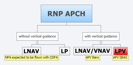
Final approach procedures based on GNSS are classified as RNP approaches (RNP APCH, as shown in the next figure), namely: Lateral Navigation (LNAV) with GPS lateral guidance and no vertical guidance; LP with GPS + SBAS (EGNOS) for lateral guidance (CAT-I localizer performance) and no vertical guidance; Lateral Navigation/Vertical Navigation (LNAV/VNAV) with GPS lateral guidance and Baro-Vertical Navigation (VNAV) vertical guidance (Baro-VNAV approach procedures can be flown with SBAS vertical guidance upon the approval of the Air Navigation Service Provider (ANSP)) and the LPV (Localizer Performance with Vertical Guidance) with GPS + EGNOS for both lateral and vertical guidance.
Figure 4. RNP approaches.
Those procedures not including vertical guidance are intended to be flown with the Constant Descent Final Approach (CDFA) technique (to avoid dangerous dive and drive practices), supported by most Flight Management Systems (FMS).
Regarding the operational LPV main figures, the European regulation (EU OPS -REGULATION (EC) No 859/2008 usually known as EU OPS) allows LPV operational minima (Decision Height – DH) down to 250 ft, expected to be possibly lowered down to 200 ft by 2015 (LPV-200), similarly to what is already permitted by the FAA, in the United Sates for WAAS based LPV approaches (a DH of 200 ft would make LPV approaches very competitive, when benchmarked against ILS CAT-I, precision approach, or even Ground Based Augmentation System (GBAS) CAT-I precision approach).
In the last few years, about 150 LPV procedures (status as of July 2014) have been published in European airports, and the number of procedures and countries introducing EGNOS is continuously increasing.
Euromed GNSS I/METIS and Euromed GNSS II/MEDUSA
In parallel with the development of the infrastructures necessary for extending EGNOS availability across the Euromed region, the European Commission has put in place initiatives to prepare and assist the Euromed countries for the optimal use and adoption of the relevant services.
These consist in two sequential projects, the first being Euromed GNSS I/METIS project and the second being Euromed GNSS II /MEDUSA.
Running from mid 2006 up to the end of 2009, METIS acted as a pioneer in the Euromed countries and built national/regional liaisons with decision-makers and key stakeholders, interested in sharing experience and absorbing know-how. The project assisted the 10 Euromed countries to identify their priorities in relation to the use of EGNOS services, to validate the relevant opportunities from the strategic/social and economic perspectives, and to elaborate a suitable strategy and a plan of actions for facilitating EGNOS adoption and exploitation.
MEDUSA Case Study in Tunisia: LPV Approaches in the Airport of Monastir Using EGNOS
As part of the technical assistance actions programme in the priority domains, MEDUSA implements demonstrations and validations of EGNOS services in concrete applications.
For EGNOS SoL, the technical assistance action consisted in the validation of GNSS approaches, including LPV approaches, designed and constructed in MEDUSA along with the relevant safety assessment and business case for the airport of Monastir in Tunisia (35°45’29’’ N 10°45’17’’ E). The selection of the airport was driven by a trade off between the EGNOS service availability with required APV-I performances and the specific needs of the Tunisian Air Navigation Service Provider – ANSP (OACA, Office de l’Aviation Civile et des Aéroports). According to OACA, Monastir is among the airports in Tunisia presenting favourable conditions, in terms of operational constraints and traffic, for concretely proving the added value of EGNOS for final approaches.
The airport has two runways, RWY 07 and RWY 25, the former is equipped with an ILS CAT-I, the latter only supports NPA approaches. The installation of an ILS in RWY 25 was discarded due to technical constraints. This infrastructure has proven to be insufficient to fully cover the airport needs, that suffers some Delays-Diversions-Cancellations (DDCs) as a result of local specific meteorological conditions, frequent fog banks entering from the sea in the early morning, combined with desert haze. These conditions make LPV ideal procedures, as backups to RWY 07, and enabling APV approaches to RWY 25. Finally, Monastir’s TWR ATC (Tower Air Traffic Control ) staff has been involved in OACA’s PBN development, for which they were ideal candidates to evaluate the benefits possibly achievable from the use of EGNOS.
This MEDUSA’s technical assistance action is the first complete experience for the use of EGNOS SoL service outside Europe. It was conceived as a realistic exercise of RNP APCH procedures implementation, following the guidelines provided by ICAO in the “EUR RNP APCH Guidance Material (EUR Doc 025)” and including all the activities required, from the scenario adequacy study to flight validation and the requirements analysis for the final publication in the AIP (Aeronautical Information Publication). OACA was directly involved in all activities, providing inputs/feedbacks and for training purposes.
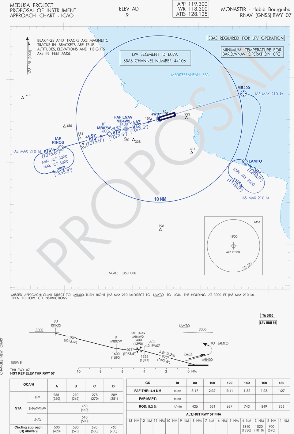
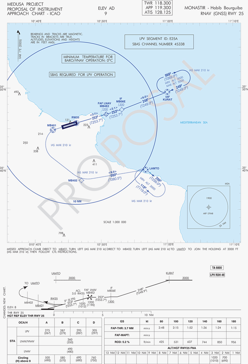
A set of three GNSS based approach procedures was produced for each RWY, following ICAO 8168 PANS OPS design principles. The next figures show the combined charts type elaborated, that include minima boxes for three RNP approaches (LNAV, LNAV/VNAV and LPV). The procedures construction preserves the current Monastir arrivals structure, following airspace management principles and facilitating the operational approval. As illustrated in the charts, in both cases for the three minima the calculated OCH (Obstacle Clearance Height) values improve with respect to the already existing conventional approaches, providing significant operational and safety benefits.
Figure 5. GNSS approaches for RWY 07.Figure 6. GNSS approaches for RWY 25.
An on-site GNSS performance monitoring campaign was performed by OACA, with the support of GEMCO’s staff, 3 months before the flight trials schedule, covering both EGNOS and GPS signal performances. Besides, an APV-I availability study for the area and specifically for Monastir airport during 1 month before the flight validation was purposely elaborated by the European EGNOS service provider (ESSP). Both analyses, confirmed suitable APV-I performance in terms of availability and continuity, making feasible the implementation of LPV approach procedures in line with ICAO prescriptions.
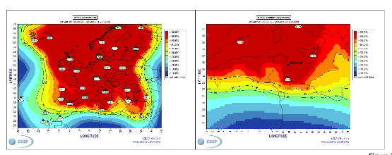
The next figures show the EGNOS APV-I availability and continuitymeasured on one day during the period of the flight validation (conducted from 30 January to 1 February 2014), in particular at Monastir airport for the considered time-lag:
APV-I availability was over 99%;
APV-I continuity presented a total value lower than 5×10⁻⁴/15s;
95th percentile of Horizontal APV-I accuracy was between 1.1 and 1.2 meters and the 95th percentile of Vertical APV-I Accuracy is around 1.4 meters, thus showing a very good accuracy level;
Horizontal and Vertical safety indexes were lower than 0.25, representing a very good integrity margin.
Additionally, the results of the on-site GNSS performance monitoring campaign showed quite stable performances with small fluctuations during the whole period of observation, and no problems or outages were observed.
(EGNOS APV-I Availability is defined as the percentage of epochs in a month in which the Protection Level are below Alert Limits for this APV-I service (HPL<40m and VPL<50m) over the total period (source: ESSP).
EGNOS APV-I Continuity Risk is defined as the result of dividing the total number of single continuity breaks using a time-sliding window of 15 seconds by the number of samples with valid and available PA navigation solution. A single continuity break occurs if the system is available at one epoch and becomes not available for the following 15 seconds (source: ESSP).)
Figure 7. APV-I availability on 31.01.2014.Figure 8. APV-I continuity on 31.01.2014.
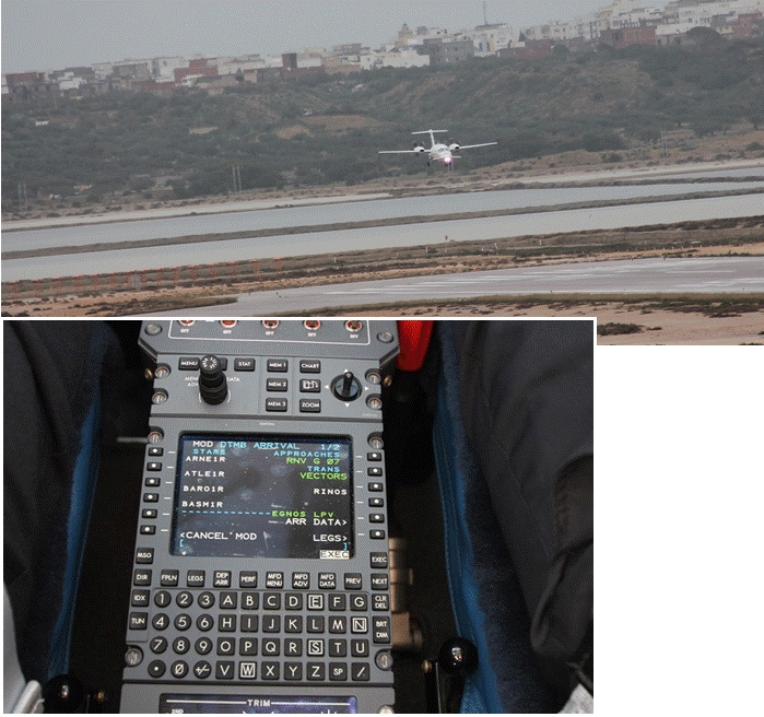
The flight validation campaign was carried out according to ICAO doc 9906 with a Piaggio P180 Avanti II (from ENAV flight inspection department) suitably equipped with UNIFIS 3000 system and a Rockwell Collins FMS 3000 with SBAS LPV approach capabilities.
Figure 9. Piaggio P180 Avanti II aircraft and the FMS messages during the flight validation.
The outcomes of this concrete experience have allowed the Tunisian authorities to identify the main elements for the publication of the validated procedures in their national AIP. They have also contributed to the analysis of the necessary process for the operational adoption of GNSS, including EGNOS, in aviation in countries beyond the EU boundaries.
The activities performed on performance assessment have been preparatory for discussions on GNSS monitoring and data recording on going at ICAO Navigation System Panel level, that would produce ICAO guidelines for States.
Therefore, this Tunisia’s “case study” represents a practical and realistic example that could be beneficial for the other non-EU countries in terms of best practice and lesson learnt. Moreover, methodology and guidelines have been derived to be possibly injected to other non-European countries interested to introduce EGNOS operations in aviation.
Lessons Learned and Outlook
Through its achievements, MEDUSA is opening the way for the introduction of EGNOS SoL service in North Africa and Middle-East region, and it is also defining a suitable path to be followed by other interested non-European countries. Overall, MEDUSA is continuing to confirm the ability to foster cooperation and involvement in EGNOS programme of the great majority of the Euromed countries. Further to Tunisia, other Euromed countries have already expressed their interest in relation to the EGNOS use in aviation, considering each country’s strategy and also in the light of a common shared regional perspective. Besides, the results obtained by MEDUSA are useful also for other regions interested to use EGNOS in aviation.
Additionally, MEDUSA is clearly showing that Euromed region, presently lacking the full support of SBAS technologies, represents an opportunity for EGNOS service extension, with many benefits for the countries of the region and for Europe.
On one hand, being SBAS an effective and efficient technology to enable the aviation community of the Euromed countries to comply with ICAO recommendations on PBN implementation by year 2016 across the region, the services coverage extension of existing SBAS systems (EGNOS in the case of the Euromed countries) can be one of the most efficient ways to move forward. In fact, the Euromed national ANSPs consider the readiness of EGNOS SoL service as one of the main drivers and factors when designing their PBN strategy. EGNOS, which is already operational since 2009 and available for use in aviation since 2011, can deliver added-value services to the Euromed region, just by leveraging the existing European infrastructure with only incremental, marginal and natural extension. The EGNOS coverage extension across the Euromed region can provide significant benefits and particularly to those Euromed countries with few ILS or reduced navaids coverage, and enhance safety and efficiency to the whole aviation community.
On the other hand, the European Union has to gain from an EGNOS-based long term links with its neighbouring regions, by increasing bilateral/multilateral cooperation and interaction (e.g. assistance, mutual cooperation) among public and semi-public bodies (e.g. ANSPs, Civil Aviation Authorities), by strengthening EGNOS SoL coverage in the southern/peripheries of EU (e.g. Malta, Cyprus, Greece, Southernest Italian islands, Canary islands), by pursuing and supporting other EU policies in several sectors (like transports, e.g. harmonizing aviation safety standards across the Mediterranean, Transport Policy of the Mediterranean Partners), and last but not least by achieving a first step towards EGNOS extension to the whole African continent which will bring in similar, additional benefits just described above.
The Federal Aviation Administration (FAA) today granted five regulatory exemptions for unmanned aircraft systems (UAS) operations to four companies representing several industries that promise to benefit from UAS technology, including Trimble Navigation Ltd.
The four companies that received exemptions want to fly UAS to perform operations for aerial surveying, construction site monitoring and oil rig flare stack inspections.
“Unmanned aircraft offer a tremendous opportunity to spur innovation and economic activity by enabling many businesses to develop better products and services for their customers and the American public,” Transportation Secretary Anthony Foxx said. “We want to foster commercial uses of this exciting technology while taking a responsible approach to the safety of America’s airspace.”
The commercial entities that received exemptions today are Trimble Navigation, VDOS Global, Clayco, and Woolpert (two exemptions). The FAA earlier granted exemptions to seven film and video production companies. This is the first exemption granted to a leading GNSS firm.
Secretary Foxx found that the UAS in the proposed operations do not need an FAA-issued certificate of airworthiness because they do not pose a threat to national airspace users or national security. Those findings are permitted under Section 333 of the FAA Modernization and Reform Act of 2012.
The firms also asked the FAA to grant exemptions from regulations that address general flight rules, pilot certificate requirements, manuals, maintenance and equipment mandates. In their petitions, the firms said they will operate UAS weighing less than 55 pounds and keep the UAS within line of sight at all times.
The exemption will allow Trimble to conduct commercial operation of its UX5 Aerial Imaging Solution. The UX5 is an unmanned fixed-wing aircraft targeted at the surveying, agriculture, oil and gas, mining, construction, environmental industries. The system autonomously captures a series of high-resolution images during flight, which is typically up to 50 minutes covering as much as 2.3 square kilometers (approximately 1 square mile) when flying 120 meters (approximately 400 feet) above the ground. Using Trimble Business Center Aerial Photogrammetry software, images are used to easily generate 2D and 3D deliverables such as orthomosaic images, three-dimensional point clouds and contour maps. The Trimble UX5 enables the collection of large amounts of data, often faster than traditional surveying or mapping technologies.
The Trimble UX5 surveys a construction site. Photo: Trimble
“We are pleased to be among the first companies to receive an exemption from the FAA authorizing commercial operation of UAS,” said Erik Arvesen, vice president of Trimble’s Geospatial Division. “This decision reflects Trimble’s efforts to responsibly operate its UAS business in the U.S. while the FAA addresses air safety issues in opening the NAS for commercial UAS operations on a broader scale. Trimble will continue its efforts to support the FAA’s decision-making process and to provide opportunities for our customers to safely use the UX5 to capture accurate geospatial data for a wide range of applications such as surveying, oil and gas, mining, construction and many more.”
“In the agriculture market, the FAA exemption moves Trimble one step further with the opportunity to provide a solution for safe and legal UAS operations that can benefit growers, ranchers, water management contractors, agronomists and other ag service providers,” said Joe Denniston, vice president of Trimble’s Agriculture Division. “High-speed aerial imaging is a powerful tool that can quickly and easily capture aerial images for scouting and monitoring crop health, locating cattle and their available forage over large areas, measuring crop height, and generating topographic maps and models for land leveling and drainage applications. As a result, the system can be a powerful data collection tool that can aid with recommendations to improve farming operations.”
In granting the exemptions, the FAA considered the operating environments and required certain conditions and limitations to assure the safe operation of these UAS in the National Airspace System. The agency also will issue Certificates of Waiver or Authorization (COAs) that mandate flight rules and timely reports of any accident or incidents..
“The FAA’s first priority is the safety of our nation’s aviation system,” said FAA Administrator Michael Huerta. “Today’s exemptions are a step toward integrating UAS operations safely.”
As of today, the agency has received 167 requests for exemptions from commercial entities.