The Federal Aviation Administration (FAA) has issued additional drone flight restrictions over U.S. federal prisons, military bases and Pearl Harbor, effective Feb. 26.
At the request of its federal security partners, the FAA is using its existing authority under Title 14 of the Code of Federal Regulations (14 CFR) § 99.7 — “Special Security Instructions” — to address concerns about drone operations over national security sensitive facilities by establishing temporary unmanned aircraft system (UAS) specific flight restrictions.
Information on the FAA Notice to Airmen (NOTAM), which defines these restrictions, and all of the currently covered locations, can be found at the FAA’s UAS Data Display System, which provides an interactive map, downloadable geospatial data, and other important details.
A link to the restrictions is also included in the FAA’s B4UFLY mobile app.
Additional, broader information regarding flying drones in the National Airspace System, including frequently asked questions, is available on the FAA’s UAS website.
In cooperation with Department of Justice (DOJ) and Department of Defense (DOD), the FAA is establishing additional restrictions on drone flights up to 400 feet within the lateral boundaries of the following federal facilities:
Federal Correctional Institution Allenwood Medium in Allenwood, PA
Federal Correctional Institution Beaumont Medium in Beaumont, TX
Federal Correctional Institution Butner Medium I in Butner, NC
Federal Correctional Institution Butner Medium II in Butner, NC
Federal Correctional Institution Coleman Medium near Sumterville, FL
Federal Correctional Institution Florence in Florence, CO
Federal Correctional Institution Forrest City Medium in Forrest City, AR
Federal Correctional Institution Hazelton near Bruceton Mills, WV
Federal Correctional Institution Lompoc in Lompoc, CA
Federal Correctional Institution Oakdale I in Oakdale, LA
Federal Correctional Institution Oakdale II in Oakdale, LA
Federal Correctional Institution Petersburg near Hopewell, VA
Federal Correctional Institution Pollock in Pollock, LA
Federal Correctional Institution Terre Haute in Terre Haute, IN
Federal Correctional Institution Tucson in Tucson, AZ
Federal Correctional Institution Victorville Medium I in Victorville, CA
Federal Correctional Institution Victorville Medium II in Victorville, CA
Federal Correctional Institution Yazoo City Medium in Yazoo City, MS
Federal Detention Center Honolulu in Honolulu, HI
Federal Detention Center Houston in Houston, TX
Federal Detention Center Miami in Miami, FL
Federal Detention Center Philadelphia in Philadelphia, PA
Federal Detention Center SeaTac near Seattle, WA
Federal Medical Center Carswell near Fort Worth, TX
Federal Medical Center Fort Worth in Fort Worth, TX
Federal Medical Center Rochester in Rochester, MN
Metropolitan Correctional Center Chicago in Chicago, IL
Metropolitan Correctional Center New York in New York City, NY
Metropolitan Correctional Center San Diego in San Diego, CA
Medical Center for Federal Prisoners Springfield in Springfield, MO
Metropolitan Detention Center Brooklyn in Brooklyn, NY
Metropolitan Detention Center Guaynabo in Guaynabo, PR
Metropolitan Detention Center Los Angeles in Los Angeles, CA
Fort Detrick in Frederick, MD
Fort Gordon near Augusta, GA
Fort Lee near Richmond, VA
Holston Army Ammunition Plant near Kingsport, TN
McAlester Army Ammunition Plant in McAlester, OK
Radford Army Ammunition Plant in Radford, VA
Joint Base McGuire near Trenton, NJ
Pearl Harbor Naval Defense Sea Area in Honolulu, HI
These changes, which have been highlighted by FAA NOTAM FDC [9/2586], are pending until they become effective on Feb. 26. Note that there are only a few exceptions that permit drone flights within these restrictions, and they must be coordinated with the individual facility or the FAA.
Operators who violate the flight restrictions may be subject to enforcement action, including potential civil penalties and criminal charges.
The FAA is continuing to consider additional requests by eligible federal security agencies for UAS-specific flight restrictions using the agency’s § 99.7 authority as they are received. Additional changes to these restrictions will be announced by the FAA as appropriate.
Features include enhanced ADS-B, SBAS and georeferenced charts.
Collins Aerospace’s Pro Line Fusion avionics upgrade for Pro Line 4-equipped Bombardier Challenger 604 series aircraft has been certified by the U.S. Federal Aviation Administration (FAA).
Working closely with Bombardier as the original aircraft manufacturer and Nextant Aerospace as the installation design certification lead, this sole all-in-one solution complies with pending mandates while modernizing the flight experience for pilots.
The Pro Line Fusion upgrade enhances the operational capabilities of the Challenger 604 aircraft to a similar level as that of the Challenger 605 and Challenger 650 jets equipped with Collins Pro Line 21 Advanced, while providing Challenger 604 operators with a solution to meet future regulatory requirements.
Among these enhancements, the upgrade replaces the factory-installed CRT displays with three 14.1-inch widescreen LCD displays with configurable windows. Features designed to improve situational awareness and reduce pilot workload for Bombardier Challenger 604 aircraft owners include:
A fully loaded package of baseline equipment for operation in modernizing global airspace — beyond ADS-B mandate compliance, offering SBAS-capable GNSS, localizer performance with vertical guidance (LPV) approaches, radius-to-fix (RF) legs and more
Geo-referenced electronic navigation charts that display own-ship aircraft position
The Challenger 604 Pro Line Fusion retrofit solution, which is already available for several Beechcraft King Air and Cessna Citation CJ aircraft, is part of our ongoing effort to provide owners with modern technology, enhanced situational awareness and compliance with airspace mandates,” said Christophe Blanc, vice president and general manager, business and regional systems for Collins Aerospace. “The Challenger 604 business jet is a highly-valued, long-haul aircraft that will be able to continue flying well into the future with this upgrade.”
The upgrade is available exclusively throughout Bombardier’s extensive network of service centers and Nextant Aerospace.
NovAtel has been awarded a contract from the United States Federal Aviation Administration (FAA) to design, produce and deliver 40 next-generation Ground Uplink Station (GUS) Signal Generators to support the FAA’s safety-of-life WAAS navigation service. The service provides safety-critical infrastructure for the North American aviation navigation network.
GUS signal generator. (Photo: NovAtel)
The contract also includes ongoing engineering support services for NovAtel’s complete portfolio of satellite-based augmentation system (SBAS) products deployed by the FAA, including the WAAS G-III reference receiver platform.
The FAA has relied on NovAtel’s safety-critical SBAS technology for more than 20 years, starting with NovAtel’s first-generation WAAS reference receiver that was created in the 1990s.
Developed by the FAA, the WAAS network is a safety-critical navigation aid that allows aircraft to use GPS for all phases of flight. Every time an aircraft takes off or lands within the WAAS coverage area, NovAtel technology is generating and processing data that allows aviators to make precision approaches to any airport.
Since the program’s inception, NovAtel has provided the FAA with technology that delivers high-precision GPS receiver measurements and navigation information from WAAS Reference Stations and the GUS infrastructure.
Under this new contract, NovAtel will help modernize the WAAS network by upgrading and extending support for the network’s GUS infrastructure. The next-generation of GUS signal generators, which are designed specifically for SBAS ground uplink systems, will include independent L1 and L5 signal paths to precisely control the frequency and phase of L1 and L5 code and carrier for dual-frequency SBAS.
A GUS receiver system based on the WAAS G-III receiver platform will also be released along with the signal generator to complete the modernized GUS control loop.
“We have a long history with the FAA and have worked very closely with the WAAS program team to develop multiple-generations of SBAS infrastructure,” said Jonathan Auld, vice president of engineering and safety critical systems at NovAtel. “NovAtel remains committed to supporting the FAA and their safety of life WAAS service and we are excited to deliver this critical next-generation technology for SBAS modernization.”
Space Based Augmentation Systems (SBAS) – known in North America as the Federal Aviation Administration’s (FAA’s) Wide Area Augmentation System (WAAS) – have been fully operational in one form or another for several years. The FAA’s incremental improvements to integrity, accuracy and reliability in WAAS have brought the system to a point where we have precision en-route navigation for aircraft, and we can also land aircraft using WAAS signals at thousands of airports in the US and in Canada.
Why not Mexico, which also benefits from the same WAAS coverage? More on that later, as we piece together the many parts of the complex SBAS mosaic.
SBAS precision approach coverage, May 2016. Graphic: FAA Tech Center, Lockheed Martin, GMV
Europe benefits from high-accuracy en-route navigation, and there are also hundreds of operational approaches using the European Geostationary Navigation Overlay Service (EGNOS) SBAS.
In India, the GPS Aided Geo-Augmented Navigation (GAGAN) system provides accurate en-route navigation and approach capability. However, ionospheric disturbance may limit some aspects of performance.
Japan established the Multi-functional Satellite Augmentation System (MSAS) SBAS, and has benefited from improved en-route navigation, but it’s possible that the more limited geographic distribution of GPS ground reference stations has restricted improvements to approach capabilities.
But what happened to the International Civil Aviation Organization (ICAO) concept from 2007, supported by all the ‘aviation-going’ countries of the world, that SBAS would evolve and eventually multiple national systems would provide coverage around the rest of the world, maybe even by 2016?
Countries in Asia, South America, Africa and the continent of Australia all appear to have looked closely into establishing their own SBAS, but nothing seems to have come out of these investigations. Technical issues, cost, and political obstacles have all hindered global SBAS progress.
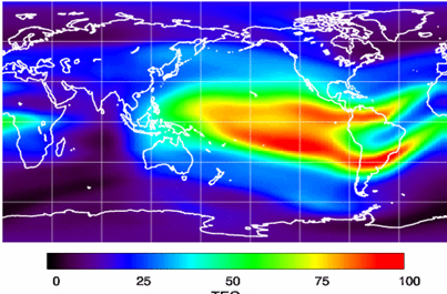
The ionospheric challenge. Graphic: GMV and Lockheed-Martin
Technical Issues. Ionospheric scintillation problems around the Equator seem to be at the root of most technical problems for SBAS. Getting to the required level of probable, bounded system error is hugely difficult. The iono disturbance ‘blob’ follows the sun around the Equator and wipes out any chance of satisfactory system performance when it passes over Equatorial countries.
As total electron count (TEC) increases, the ionospheric grid, which most SBAS use to predict ionospheric variation across their geographic area between fixed reference stations, well, it just doesn’t work anymore.
Cost. The capital cost of building a satellite-based augmentation system and the on-going cost of maintaining a bunch of geographically distributed reference sites, building and launching GEO satellites or renting transponders on someone else’s orbiting asset, establishing, operating and maintaining redundant uplink stations, redundant terrestrial data links, and setting up control systems that collect and create the SBAS uplink message — it all adds up. Millions and maybe even billions of dollars or equivalent, in total, have been spent by those select countries who could afford their own SBAS. Others named above have lesser financial resources upon which to draw.
Political Obstacles. One of the trickiest issues is sovereignty: the need for a country to control its own navigation and landing system. This has likely been the source of most resistance to more SBAS systems being set up and shared by bordering countries around the world.
For a large number of smaller countries, SBAS would only make sense if it was shared across a number of neighboring countries, but that means relinquishing sovereignty to some degree. In several regions of the world a number of geographically adjacent countries don’t particularly like each other, never mind thinking of such sharing/collaboration.
National sovereignty, by the way, isone of the main reasons that existing satellite navigation systems underpinning SBAS, such as Galileo, GLONASS, IRNSS (now NAVIC), QZSS and of course BeiDou have all been put in place.
Another problem with potential SBAS sharing across adjacent countries stems from responsibility for liability. Should something not work and an accident ensues from such a malfunction, who’s liable? Mexico seems to have adopted the view that since the US provides WAAS on what could be called an ‘as-is’ basis, then the potential liability issue seems to trump using the system.
Solutions? Technical issues with the ionosphere may soon be resolved by using dual-frequency L1/L5 airborne receivers that directly calculate their own ionospheric corrections, rather than using the computed SBAS iono grid. If we add in dual-frequency E1/E5a signals from Galileo, things start to get even better. New requirements and prototype equipment are already being developed for dual frequency multi-constellation airborne receivers. Airbus anticipates equipping aircraft with such receivers around 2025. Could this solve the SBAS technical issue for Equatorial countries?
ARINC (now a UTC/Rockwell Collins company) and SITA (in Europe) have been providing commercial aircraft with operational communications services on a pay-for-use basis for a number of years, and this is notarized as an accepted means of compliance within ICAO policy/requirements:
From ICAO Doc. 9161, Sec. 3.99: “A group of states or a regional organization might also undertake to operate the augmentation satellite service required, either by themselves or by contracting a commercial or government organization to do so on their behalf.”
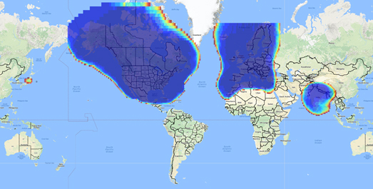
ARINC en-route coverage. Graphic: ARINC
Aireon has partnered with NAV CANADA, the Irish Aviation Authority (IAA), Enav, NATS and Naviair, as well as Iridium Communications and Harris Corporation to provide real time ADS-B data (GPS position output from aircraft) to air-traffic control providers. Aireon’s payloads on the new Iridium NEXT Low-Earth Orbit (LEO) satellite constellation will receive aircraft ADS-B messages and relay them to Air Traffic Controllers in real-time.
There are 66 Iridium NEXT satellites in operation, with significant overlap and redundancy built into the system to enable this safety-of-life service to be provided on a pay-for-use basis to the aviation industry. We could at last know the location of every suitably equipped aircraft in the air, in almost real-time. The ICAO requirement is for an update rate of 15 minutes.
Inmarsat ADS-C is a similar service available to aircraft on a contracted, pay-for-use basis via Inmarsat GEO satellites.
Market Solutions. If a substantial company showed up with a worldwide distributed SBAS solution and offered it on a fee for service basis, why wouldn’t countries that are already accustomed to ARINC and SITA pay-for-use communications? The Aireon international aircraft tracking system, to be provided on the same basis, adds to the credibility of such a pay-for-use service.
So why wouldn’t these accepted services demonstrate to those countries concerned about control and national sovereignty that an SBAS service could be provided on this basis?
The liability for provision of service sits with the providers, so user countries/airlines would have someone to turn to about liability issues, and there presumably could be contract terms to provide system performance guarantees.
No huge capital costs, no system to construct, nor staff to operate or maintain, and yet a level of control similar to that which has been around for commercial aircraft communications for decades.
Would this be of interest to countries that have not yet jumped on the SBAS bandwagon? A definite ‘maybe,’ we could imagine? What’s not to like?
The punch line to all this is that Lockheed Martin and GMV (Spain) have teamed to challenge these non-SBAS countries with a solution which may appeal.
Uralla reference test site. Photo: Lockheed-Martin
To present convincing evidence that it would work, a dual frequency GPS (L1/L2) + Galileo (E1/E5a) reference site has been set up in collaboration with Geoscience Australia and Land Information New Zealand. The reference site is located at Uralla, New South Wales on Australia’s East Coast, where it gathers data demonstrating bounded errors within the operational range which could enable GNSS approach capability.
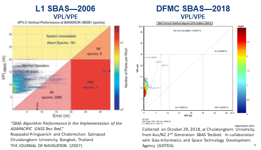
L1 (2006) vs. DFMC (2018) SBAS at Bangkok. Graphic: Lockheed-Martin, GMV
Another test site in Bangkok, Thailand has demonstrated that existing L1-only SBAS in this area cannot manage this performance (all current SBAS are L1 only), but that with dual-frequency multi-constellation (DFMC) GPS L1/L2+Galileo E1/E5a, the required performance limits could be met.
Lockheed Martin has also been using the Uralla uplink site to test the uplink and downlink of dual-frequency SBAS-like test messages.
The Moral of the Story. There are no miracles as yet, but interest in the pay-as-you-go SBAS concept appears to be growing, and the LM/GMV team continues to work to bring their approach to market.
A large number of countries could well benefit from the high accuracy, integrity and continuity of SBAS service if this all comes together.
This report covers a number of UAV topics, including the news of another U.S. Federal Aviation Administration (FAA) program to advance drone integration in the U.S. National Airspace System (NAS); an initial effort towards Type Certification for a larger UAV/UAS; cautious steps to protect U.S. Navy and Coast Guard ships from unwanted drone overflight; and what would appear to be a surge in the number of acquisitions across the industry.
FAA Integration Pilot Program
There are signs of growing momentum to get UAVs flying in the U.S. NAS. The FAA Integration Pilot Program (IPP) website indicates that this latest initiative is spread across a number of different applications, locations and supporting organizations. The FAA cites the following objectives for IPP:
Connecting local and national UAS integration interests
Improving local, state and tribal communications
Addressing security and privacy risks
Speeding up special authorizations.
So it’s perhaps more about getting organizations at the local level into the picture, and fostering cooperation with national interests. But, at the same time, pilot projects will feed knowledge into the hopper of how to get UAVs into the U.S. NAS.
Operational concepts to be investigated include night operations, flights over people, flights beyond visual line of sight, package delivery trails, testing detect-and-avoid technologies and verifying the reliability and security of UAS data links.
Certification Program underway for Insitu ScanEagle3
Along the same lines, Insitu is working with FAA staff towards certification of the commercial ScanEagle3 drone system to enable flights in U.S. controlled airspace. A recent three-day Type Certification Board meeting held between FAA and Insitu included launch-to-capture flight tests, plus review of applicable standards, flight training and technical publications and manuals to determine Insitu’s basis for the proposed UAS Type Certification of the ScanEagle3 in 2019.
Once an aircraft or UAS gains Type Certification, it should be possible to fly that model on a regular basis, without the need for special FAA authorization of individual operations, as is currently the requirement for drones — other than for small UAS (sUAS), which already have FAA approved operational regulations. This effort could also clear the way for certification of larger drones to regularly operate in the NAS. Filing a flight plan with local FAA controllers prior to each flight would then typically be required, as is standard for all manned aircraft.
FAA review teams examine Insitu’s ScanEagle3 at a type certification board meeting in Bingen, Washington (Photo: Insitu)
At the recent review meeting with FAA team members from various certification groups, Insitu discussed its internal culture of safety, which is in line with the FAA’s extremely strict safety standards. The design and technology of ScanEagle3 was demonstrated, and the maturity of Insitu as an aircraft manufacturer was emphasized.
The FAA teams participated in an overview of Insitu’s Project Plan for Certification, examining Insitu’s detect-and-avoid (DAA) capability planning, safety management system and model-based engineering processes.
Insitu is hopeful that Type Certification will enable ScanEagle3 to be applied quickly to all types of operation, which could include data collection, analysis and delivery; aerial infrastructure survey; disaster recovery; and wildfire suppression – without the delay currently associated with seeking permits and overcoming temporary flight restrictions.
FAA restricts drone operations near sensitive U.S. facilities
Meanwhile, the FAA flexed its legal muscles to restrict drone flights near U.S. Navy (USN), U.S. Coast Guard (USCG) and Department of Energy (DoE) facilities and assets. Growing concerns with potential malicious drone flights over sensitive, high-priority facilities and ships apparently prompted the FAA to issue two NOTAMs (Notice to Airmen). The first notification describes the locations and the assets – in this case, ships operating from two bases — and includes the form of restrictions that are being applied.
Drone flights have been restricted around USN and USCG vessels operating near Naval Base Kitsap in Washington state and Naval Submarine Base Kings Bay in Georgia. Drones are not allowed to get closer than 3,000 feet laterally and 1,000 feet vertically from vessels. And the NOTAMs carry the dire warning that these ships have the authorization and ability to take whatever action they feel necessary to protect themselves from such threats.
In other words, if the nut-case flying an unwelcome drone penetrates the restricted area around a Navy or Coast Guard ship, the target ship might well take out the unwanted drone. And the FAA may also pursue civil penalties and/or criminal charges against the operator for disobeying the restrictive notice.
The second NOTAM warns drone flyers to remain clear of all national Department of Defense (DoD) and DoE facilities and mobile assets, as well as USCG vessels. With UAVs carrying explosive devices becoming more common in areas of conflict or political unrest (in Venezuela, for instance), it’s not surprising that U.S. DoD is concerned this could soon start to happen closer to home.
Industry consolidation continues
Finally, following a letter of intent from Textron Systems to buy Howe & Howe Technologies a land mobile robotics defense outfit, drone industry consolidation also seems to be gaining momentum.
Howe & Howe’s land vehicles are built and proven for extreme environmental conditions, and U.S. government customers have selected Howe & Howe’s small, highly mobile Ripsaw Super Tank for its speed, mobility and off-road performance, while the RS2-H1 SMET was down-selected to compete to be the U.S. Army’s first platoon load-carrying robot, after completing a 60-mile test through swamp and jungle terrains.
Textron Systems continues to position itself as a global leader in autonomy applications in air, land and sea.
In addition, Delair has just announced an agreement to acquire the key assets of Airware — a developer of software analytics tools for data collected by drones. The acquisition quickens Delair’s growth and increases options for the commercial UAV market. Delair provides end-to-end solutions, including fixed-wing drones, cloud-based data processing and analysis, local customer support and custom consulting services.
Delair UX11 mapping drone (Photo: Delair)
The acquisition is through an asset purchase of Airware’s technology, including proven software, related personnel in Paris, existing customer relations and established distribution channels. Airware’s data management and data analysis tools will be highly complementary with Delair’s existing solutions and will also expand Delair’s U.S. market presence, providing access to additional key industrial markets.
Airware, based in California, has provided a cloud-based software solution to large companies in the construction, mining and insurance industries. Its software solution was developed with support from Caterpillar and has been distributed by Caterpillar dealers to more than 50 countries to improve the productivity and safety in mines, quarries and construction sites.
Delair, with more than 180 employees worldwide, has customers in a number of industries including mining, construction, energy, utilities, oil and gas, transportation and security.
PrecisionHawk has also announced the purchase of Uplift Data Partners, which provides turnkey inspection services for construction, building information management (BIM) and real-estate. This is PrecisionHawk’s fifth acquisition during 2018 — earlier acquisitions have included Droners.io, Airvid, HAZON and InspecTools. These acquisitions have created dynamic synergy, and provided enhanced airborne intelligence with strengthened data value for PrecisionHawk.
Uplift’s commercially trained drone pilots will join PrecisionHawk’s network of more than 15,000 drone pilots, one of the largest networks of its kind. Suzanne El-Moursi, CEO of Uplift, will join PrecisionHawk’s executive team and will manage the company’s construction business.
The intent is for customers to receive best-in-class aerial data and analytics for complex construction and facility inspection projects, through combined PrecisionHawk’s advanced products and services, and Uplift’s industry experience and training standards.
PrecisionHawk and Uplink will combine products for construction projects. (Photo: PrecisionHawk)
Uplift Data Partners has been an integrated subsidiary of Clayco, an architecture, engineering, design-build and construction firm, with more than $2 billion in annual revenue. Following the spin-off, Clayco will still source its construction projects exclusively to PrecisionHawk, and will support PrecisionHawk’s board of advisors.
The construction industry has rapidly adopted commercial drone technology — transforming construction processes by decreasing the need for protracted visual inspections, shortening planning time, improving worker safety and quickly identifying problems.
And finally — Microdrones, a provider of professional UAV solutions, has announced that it has acquired geomatics service provider Navmatica Middle East (ME) with an office and team in Dubai, UAE. Navmatica ME supplies services and custom software development for geodetic positioning, airborne mapping, mobile mapping and indoor mapping.
Microdrones md4-3000 drone. (Photo: Microdrones)
The acquisition establishes a foothold in the Middle East market for commercial drones, and adds an experienced team of geomatics engineering specialists, software developers and systems engineers who have a proven track record of providing customers with high-quality geomatics services and technology.
Summary
We have FAA efforts to move further forward with UAV integration with its IPP program, first steps down the lengthy and somewhat arduous path towards the certification of larger UAVs to enable less restrictive flight in the U.S. NAS, notifications to operators to improve protection of Navy and Coast Guard ships from unwanted overflight and potential drone attack, and plenty of signs of drone service and manufacturer business consolidation — lots of what we may think of as positive indications of greater maturity and progress for the UAV industry.
The Federal Aviation Administration’s (FAA) nationwide deployment of the Low Altitude Authorization and Notification Capability (LAANC) has exceeded all of the program’s original objectives.
Since the program began with a prototype system in November 2017, LAANC has processed more than 50,000 applications from drone operators for authorization to fly in controlled airspace. The system now covers almost 300 air traffic facilities serving approximately 500 airports, providing near-instantaneous approvals and allowing operators to quickly plan their flights. View a list of the participating facilities.
LAANC helps support the safe integration of drones into the nation’s airspace. The system uses airspace data provided through temporary flight restrictions, Notices to Airmen (NOTAMs) and unmanned aircraft system (UAS) facility maps that show the maximum altitude ceiling around airports where the FAA may authorize operations under Part 107, the small drone rule for commercial and public agency operators.
LAANC Service Suppliers
The FAA has approved 14 LAANC service suppliers. Instructions on how to apply are provided by each supplier:
Drone operators also can file for airspace authorizations using the FAA DroneZone, including for areas not covered by LAANC or when the operator holds a Part 107 waiver.
“The benefits of geospatial technology are truly untold. However, when our federal agencies use geospatial data, different agencies can acquire duplicative information and waste precious taxpayer resources in the process. I am glad House leadership listened to industry stakeholders and included the Geospatial Data Act in the FAA Reauthorization Bill of 2018. This will streamline the collection of this data across the federal government while saving money, improving information accuracy, and providing a more modern system for collecting and sharing geospatial data.”
— Rep. Bruce Westerman, Arizona, introducing the Geospatial Data Act to the House of Representatives, 115th Congress
On Oct. 3, I was at a crowded after-hours event with friends in Washington, D.C., standing in a darkened corner of the room where I could both see and hear the speaker. A man approached me, a featureless silhouette in the dark tapping me on the shoulder. He introduced himself as an employee of the U.S. Geological Survey, and said he heard I was with the Federal Aviation Administration.
He asked if I knew anything about the FAA Reauthorization Bill because it had language from the Geospatial Data Act in it. His mention was the first I had heard of it. It came as a surprise. I expected a few passages from the Bill but nothing more; and, in fact, I did not expect it to even come up for a vote this year because of the divisive political atmosphere.
Two days later, on Friday, Oct. 5, President Donald Trump, along with 11 high ranking officials, signed the FAA Reauthorization Bill into law with overwhelming support. The Senate passed it 93-6, and the House passed it 398-23. The bipartisanship of this bill should have made the news – both sides of the contentious isles coming together to pass so important a piece of legislation. It happened without fanfare or recognition aside from certain circles, but within H.R. 302 was contained the entire Geospatial Data Act 2018.
An email from the Maryland State Geographic Information Committee (MSGIC) alerted me. Not even the FAA sent an email praising the aspects of the bill beyond what immediately applied to the FAA. If the stranger from USGS had not forewarned me I would not have been keen to the press release and overlooked its significance.
Most people are unaware that the Geospatial Data Act (GDA) is now law. Even fewer realize that the GDA applies not only to the FAA, but to all government agencies except for the Department of Defense and the intelligence community.
The Long and Winding Road of the Geospatial Data Act
Attempts at creating a unifying federal geospatial policy can be traced to shortly after the Civil War. There was no powerful, central, national unifying authority before then. The states were sovereign entities with their own maps, and place names did not have to be agreed upon between states.
This is visible today in the names of Civil War battles, many of which are named differently by each warring side; for example, the bloody Battle of Antietam is the same as the Battle of Sharpsburg, and the Battle of Bull Run is the same as the Battle of Manassas. Upon those hallowed grounds so many died that the dual names exist because they were paid for in blood.
War drives the need for intelligence. Geography is of paramount importance for generals. The 1860s was a boom time for surveyors and cartographers because of the Civil War and the American Indian Wars.
Additionally, in the 1860s Alaska was purchased from Russia and America built the first transcontinental railroad. Those geopolitical events changed the country, and the government needed to inventory the emerging nation.
Many companies were employed to do the work, but they were not coordinated, costing excess amounts of money. This prompted the establishment of the United States Geological Survey (USGS) in 1879 to oversee the survey companies.
Roosevelt on a digging machine during construction of the Panama Canal, circa 1908. (Photo: Library of Congress, Prints and Photographs Division)
Problems were identified among the many maps created. Place names and spelling changed from map to map. The country needed a coordinated effort to deal with these discrepancies. President Benjamin Harrison addressed this with Executive Order 28 (27-A) in 1890, establishing the Board of Geographic Names.
In 1906, during the middle of building the Panama Canal, President Theodore Roosevelt — who had direct experience with survey and mapping companies — signed Executive Order 493 renaming the Board of Geographic Names to the U.S. Geographic Board and adding to its purpose reducing duplicative survey and mapping efforts.
In 1956 the National Interstate and Defense Highways Bill was signed, beginning the interstate network we enjoy today. Building the interstates was a huge expense, and like before, many survey companies were involved. Anticipating these challenges in 1953 President Eisenhower, the Office of Management and Budget wrote Circular A-16, which identified better coordination acquiring geographic information and reducing duplicate efforts as ways to reduce costs and improve efficiency.
In 1990 during the months leading up to Gulf War I, which showed geospatial precision’s awesome power and forever changed the face of war, also brought changes to OMB Circular A-16 for more domestic purposes. The circular was revised, reflecting the influence of the digital era and establishing the Federal Geographic Data Committee (FGDC) to promote the coordination of geospatial data.
Recognizing the importance of geospatial information systems (GIS), on April 11, 1994, President Clinton signed Executive Order 12906: Coordinating Geographic Data Acquisition and Access: The National Spatial Data Infrastructure (NSDI). The executive branch continued to lead the government’s efforts to advance a unified geospatial policy.
When 9/11 Happened
Seven years later, in June 2001, Congress attempted to pass its first federal geospatial policy, but Sept. 11 changed everything. The greatest terrorist attack in U.S. history made everything else pale by comparison. National security and intelligence became the focus.
Congress tried again in 2003, the same year the National Imagery and Mapping Agency (NIMA) changed its name to the National Geospatial Intelligence Agency (NGA), but Gulf War II and the Global War on Terrorism stole center stage.
In 2005, Congress tried again, but to no avail. The bill changed names several times. The contents evolved. Attempts to introduce the bill went dormant until 2012 when it stalled again without support. Proponents continued reintroducing the bill under various names in 2013, 2014 and 2015.
In 2015 it made a second debut with the name Geospatial Data Act (GDA) and maintained that name going forward. The GDA was reintroduced in 2016, twice in 2017 and again in 2018. In total, the bill was introduced more than a dozen times since 2001. Finally, 139 years since the founding of USGS, a federal geospatial policy is now the law of the land.
You Have an Opportunity
“This legislation will significantly address how location intelligence is organized and disseminated and will foster continued strength in our industry’s partnership with government users.” — Jack Dangermond, Esri founder and CEO
It takes courageous leadership to get legislation passed. We can all breathe a sigh of relief. This great “tech-tonic” shift happened during our working lives. We can all say we were there when the world changed. This is a golden opportunity. Knowledge is power; however, knowledge is only potential power — real power is action. Step up, volunteer, and lead the change. Your agency needs you. The country needs you. Don’t let this opportunity pass you by.
Your first step is to read the Geospatial Data Act 2018 contained within the FAA Reauthorization Act, Title VII, Subtitle F: Geospatial Data, Sections 751-759. Become familiar with the GDA. Learn who the points of contact are for your agency. Make yourself known. Be a leader. When others see chaos, leaders see opportunity.
Economic Impact of the Geospatial Data Act 2018
“The economic benefits of smart infrastructure investment are long-term competitiveness, productivity, innovation, lower prices, and higher incomes, while infrastructure investment also creates many thousands of American jobs in the near-term.”
— White House, National Economic Council and the President’s Council of Economic Advisers, July 2014
Since Roger Tomlinson first created a geographic information system in the 1960s, GIS has become a multi-billion dollar global industry. By 2020, it is forecast to be nearly a half-trillion dollars annually. The global GIS market is expected to double in seven years.
GeoBuiz estimates that GIS influences 20 percent the world’s entire $80.7 trillion global annual production. According to the Countries Geospatial Readiness Index, the United States leads the world in GIS. What is amazing is that all these estimates were made prior to the passage of the GDA — the gale force winds that have thus far blown will soon become a hurricane.
The sweet spot of opportunity is the forward edge of a growing industry. In the mid-90, the growth of the geospatial industry was led by state and local government (See GeoIntelligence Insider: In Jack Maple’s Steps – Fighting Crime with GIS, May 2018). In the mid-2000s, growth accelerated due to the intelligence and military communities. The next big boom in GIS begins now as the federal government complies with the GDA. There will be an even longer growth trend internationally as other countries make their own conversions.
It is a common adage that forecasts usually overestimate the near term and underestimate the long-term, especially in regard to technology. Consider how one man’s idea to sell books online in 1995 made him the wealthiest man in the world 23 years later, or how a simple search engine in 1998 is now a global behemoth. Of course, those references are to Jeff Bezos of Amazon and to Google.
And, consider the impact GPS has made since May 1, 2000, when President Clinton discontinued Selective Availability, opening GPS to the masses. Four years later, in June 2005, Google Earth was launched. The iPhone came out two years later. Then, a year later, Google Maps with real-time navigation was released.
Businesses like Uber that depend on GPS and GIS began in 2012. Now, industries such as drones and autonomous vehicles are on the verge of exponential growth.
Apply a similar trajectory to GIS and combine it with smart technologies like the internet of things (IoT), open data, data science, artificial intelligence, augmented reality, and other emerging technologies and the growth potential is unprecedented, not to mention the infrastructure rebuild of America about to take place.
An Economic Analysis of Transportation Infrastructure Investment – White House, July 2014, National Economic Council and the President’s Council of Economic Advisers. (Image: WhiteHouse.gov)
Smart technologies will play a huge role in rebuilding the United States infrastructure like sensors, advanced materials, self-aware neural networks, IoT devices, energy recapture systems, smart lighting, and more; many such technologies will be connected geospatially.
This will require an advanced 3D Smart Grid Reference System (3D SGRS), a term I coined in 2015 when I worked at the Department of Transportation and began developing a crowdsource application for the National Address Database. I saw it becoming the framework for a 3D SGRS, enabling pinpoint accuracy of locations in X-Y-Z.
I can cover the 3D SGRS in a future article. I write about it here because it will be required in order to modernize America’s infrastructure.
Before passing any infrastructure bills, it is necessary to have a sound geospatial policy to avoid the misspending identified by the previous administrations mentioned earlier. The GDA, in essence, is the first step to modernize America. A brief overview of proposals sitting before Congress is an indicator of the economic tsunami about to be unleashed now that the GDA has been established.
Legislation has been introduced for establishing infrastructure bonds and banks for investing in infrastructure projects. Individual bills are for railroads, land, air, and sea ports; intermodal freight transfer stations, highways, critical infrastructure, rural development and stormwater systems, including water retention ponds and reservoirs that make up a large part of city and suburban green space. There are bills to fund pollution prevention programs.
Infrastructure cybersecurity is also addressed. There are bills for job creation, including employing disabled veterans in transportation. There is even a bill for proclaiming a National Infrastructure Week.
Once these legislative efforts begin getting passed, a tsunami of economic growth will be released unlike few alive have ever seen.
The Geospatial Data Act – A Matter of Necessity
“The Geospatial Data Act will save taxpayer dollars, increase government efficiency, and unlock innovation in the public and private sectors.” — Congressman Seth Moulton, Massachusetts, co-signer of the Geospatial Data Act to the House of Representatives, 115th Congress
Rebuilding America is one of the boldest, grandest and costliest undertakings the country has seen. Being one of the costliest, one has to ask where the money is going to come from.
The GDA will create entrepreneurs, new products and services, and job growth, which will generate revenue. Many infrastructure-related bills have tax incentives built into them. Money will come from the economic restructuring of trade deals currently taking place with many of the United States’ trading partners. Money will also come from America’s oil and gas renaissance.
Outline of the Geospatial Data Act 2018
This article put the Geospatial Data Act into context, but it would not be complete if it did not at least outline the major provisions of the new law.
These are the primary tenets of the GDA:
It establishes the Federal Geographic Data Committee (FGDC)
It establishes the National Geospatial Advisory Committee (NGAC)
It establishes the National Spatial Data Infrastructure (NSDI)
It establishes the National Spatial Data Asset data themes (NSDI-dt)
It establishes GeoPlatform as the clearinghouse for geospatial data
It sets Geospatial Data Standards.
Senator Orrin Hatch, who introduced the bill to the Senate four times since 2015, called it, “…a good-governance bill that will bring structure and Congressional oversight to federal geospatial data spending, accounting, and usage. The GDA will:
Dramatically reduce duplicative spending and, according to the Government Accountability Office, save the federal government billions of dollars;
Bolster federal emergency response capabilities by enabling smarter, more efficient disaster relief;
Improve infrastructure planning nationwide by providing state and local governments with access to higher-quality, more robust data.
The bill is supported by over 65 universities, industry groups, trade associations, companies, and state and local stakeholders, including the National Association of Counties and National League of Cities.”
Some of the stakeholders Sen. Hatch referred to are Bert Granberg, president of the National States Geographic Information Council (NSGIC), who stated, “From transportation, to natural resources, to homeland security, map-based digital information has quietly become mission critical to how work gets done and to future economic growth. We need an efficiency and accountability framework to build, sustain and share geographic data assets for the entire nation. The GDA delivers just that, and our members appreciate Representative Westerman’s leadership.”
Molly Schar, executive director of NSGIC, shared her thoughts, saying, “The Geospatial Data Act has been a top legislative priority for NSGIC for several years. We have worked with state governments, Congressional offices, federal agencies, and many other stakeholder groups committed to building more resilient communities by ensuring they will have access to the consistent high-quality data they need to do their jobs,”
And, after the bill’s passage she proclaimed, “It was a big win for the entire geospatial community and quite a team effort!”
For more information
This report has given you the background and the context of the Geospatial Data Act. To become intimately familiar with the GDA, I highly recommend reading the Congressional Research Service Report about GDA 2018, released Oct. 22.
On Saturday, Nov. 10, Stanford colleagues of Professor Per Enge will host a celebration of his life. A live webcast of the event will be available here at at 1 p.m. Pacific Standard Time.
The video will be available afterwards on this site.
GPS World extends this invitation to join Per’s family and friends in celebrating the wonderful life that he led and the extraordinary impact he had on those around him. Guests at the live event will be invited to share their favorite memories.
The following statement was recently read into the minutes of the Stanford Faculty Senate:
Per K. Enge, the Vance D. and Arlene C. Coffman Professor in the School of Engineering and one of the world’s foremost experts in GPS technologies, passed away on April 22, 2018, at his home in Mountain View, California. He was 64.
Per Enge, Professor and Director, Stanford University Center for Position Navigation and Time. (Photo: Stanford University)
Per was born Oct. 29, 1953, in Bergen, Norway. He immigrated at the age of 2 to the United States with his father and mother.
He earned his B.S. in electrical engineering at the University of Massachusetts at Amherst in 1975 and his MS and PhD at the University of Illinois Urbana-Champaign in 1979 and 1983, respectively. He met his wife of 38 years, Elaine, while at UMass. His son, Nick, a Stanford graduate and now a lecturer at the University of Texas at Austin, said that despite his academic upbringing, his dad was a middling student until Elaine introduced him to the library at UMass, where she was most often found.
While pursuing his advanced degrees, Per worked in industry, where he first gained experience using radio signals for terrestrial navigation. He then took a position as assistant professor at Worcester Polytechnic Institute, where he designed a radio-navigation positioning system that today has more than 1.5 million marine and land users. He also started to work on augmenting GPS so that it could be safely used for aeronautical navigation. Due to this effort he was recruited by Stanford University for a one-year visiting professorship in 1993 that was ultimately extended to full professorship.
While at Stanford, Per became one of the FAA’s most trusted advisors on the provision of aircraft guidance. He oversaw the development of two different systems that today allow airplanes to safely determine their positions within meters regardless of the weather conditions.
Per was a member of the National Academy of Engineers, a Fellow of the Institute of Navigation, and a Fellow of the Institute of Electrical and Electronics Engineers.
Per is particularly remembered as a teacher and mentor. He designed a freshman course in electric cars and aircraft and helped launch a popular massive open online course (MOOC) for the GPS community outside Stanford. He leaves behind a strong legacy of more than 40 Ph.D. students, co-workers and colleagues who have been inspired by his genuine joy in being able to work in such an exciting field.
Per is survived by his wife, Elaine, of Mountain View, and a son, Nick, of Austin. In lieu of flowers, donations in Enge’s memory can be made to a new graduate student scholarship fund under the Stanford department of Aeronautics and Astronautics. Donations can be made at https://gps.stanford.edu/resources/giving
The Federal Aviation Administration (FAA) has issued more drone flight restrictions — this time, near U.S. Navy and U.S. Coast Guard vessels operating in the vicinity of Naval Base Kitsap, Washington, and Naval Submarine Base Kings Bay, Georgia.
Drone operations are required to maintain a distance of at least 3,000 feet laterally and 1,000 feet vertically from the ships and submarines.
The Ohio-class ballistic-missile submarine USS Nebraska returns to Naval Base Kitsap-Bangor following sea trials. (Photo: U.S. Navy/Lt.Cmdr. Michael Smith, Commander, Submarine Group Nine)
At the request of the Department of Defense (DOD) and the United States Coast Guard (USCG), the FAA is using its existing authority under Title 14 of the Code of Federal Regulations § 99.7 — “Special Security Instructions” — to address concerns about potentially malicious drone operations over certain, high-priority maritime operations.
The special security instructions, provided in an FAA Notice to Airmen (NOTAM), are now in effect. Additional information on these special security instructions includes a visual depiction and geospatial definition of the relevant airspace.
The FAA also warns drone operators that the USN and USCG vessels are authorized by law to take protective action against drones perceived to be safety or security threats, which could result in seizure, damage or destruction of the drones.
Operators who don’t comply may face civil penalties and criminal charges.
Any operator with an overriding reason of public interest or necessity (such as conducting a search-and-rescue mission) to operate their drone in close proximity to the cited USN and USCG vessels must first coordinate with the USN or USCG point of contact.
In a separate Special Notice Advisory NOTAM, also effective today, the FAA strongly advises drone operators to remain clear of DOD and Department of Energy (DOE) facilities and mobile assets, as well as USCG vessels.
The notice applies nationwide and alerts operators who ignore this caution and conduct drone flights perceived to be a safety or security threat to these facilities and mobile assets could face a reaction by security forces that results in the interference, disruption, seizure, damage or destruction of their drone.
Information can be found here on these two NOTAMs, and all of the locations currently covered by § 99.7 restrictions. This website also provides an interactive map, downloadable geospatial data, and other important details. Additional information, including frequently asked questions, is available on the FAA’s UAS website.
FAA also warns about drones interfering with public safety.
The Federal Aviation Administration (FAA) has announced nine new partners to its Low Altitude Authorization and Notification Capability (LAANC) initiative, a collaboration between the FAA and the drone industry that provides near real-time processing of airspace authorizations for Part 107 drone operators nationwide who fly in controlled airspace.
Following the FAA’s successful prototype, the initiative was simultaneously opened to additional air traffic control facilities and to new industry partners. The five-month onboarding process that began in April resulted in nine new LAANC partners — Aeronyde, Airbus, AiRXOS, Altitude Angel, Converge, DJI, KittyHawk, UASidekick and Unifly.
The nine join five companies — AirMap, Harris Corp., Project Wing, Skyward and Thales Group — that have already met the technical and legal requirements to provide LAANC Services.
LAANC uses airspace data, including UAS facility maps, which shows the maximum altitude around airports where the FAA may authorize operations under Part 107 in controlled airspace. The program gives drone operators the ability to interact with industry developed applications and obtain near real-time authorization from the FAA.
The FAA next year will accept applications from parties interested in becoming LAANC service providers from Jan. 7 to Feb. 8 and from July 8 to Aug. 9. This is not a standard government acquisition; there is no Screening Information Request (SIR) or Request for Proposal (RFP) related to this effort.
In a different announcement, the FAA said that drone pilots who interfere with fighting wildfires, law enforcement efforts, or other first responders such as medical flights now are more likely to face serious civil penalties, even for first-time offenses.
Deterring interference with first responders is critical as drone use expands exponentially. Firefighting aircraft trying to contain a wildfire have to suspend flights when a drone enters the area to avoid a possible mid-air collision. A drone flying over a crime scene or accident site can hamper police or medical aircraft operations.
Ultimately, interference by a drone can cost lives.
The FAA has provided guidance for agency personnel who handle possible drone violations to refer all cases involving interference with first responders to the FAA Chief Counsel’s office for possible enforcement action.
In July 2016, Congress authorized the FAA to impose a civil penalty of not more than $20,000 for anyone who operates a drone and deliberately or recklessly interferes with wildfire suppression, law enforcement, or emergency response efforts.
Under FAA guidance, inspectors generally use non-enforcement methods, including education, for correcting unintentional violations that arise from factors such as flawed systems, simple mistakes, or lack of understanding.
However, given the potential for direct and immediate interference with potentially life-saving operations where minutes matter, offenders will immediately be considered for enforcement actions. Enforcement actions can include revocation or suspension of a pilot certificate, and up to a $20,000 civil penalty per violation.
Photo: iStock.com/NiseriN via the Federal Aviation Administration
In cooperation with the U.S. Department of Defense (DoD), the Federal Aviation Administration (FAA) is establishing restrictions on drone flights up to 400 feet within the lateral boundaries of National Geospatial-Intelligence Agency (NGA) facilities.
The temporary flight restrictions — specific to unmanned aircraft systems (UAS) — apply to three NGA facilities in or near St. Louis:
National Geospatial-Intelligence Agency (NGA) West
NGA Next West
NGA Arnold
In June, the FAA responded to federal agency requests and restricted drone operations over penitentiaries and Coast Guard bases.
The Federal Aviation Administration (FAA) is using its existing authority under Title 14 of the Code of Federal Regulations § 99.7 — “Special Security Instructions” — to address concerns about drone operations over national security-sensitive facilities.
The changes, which are highlighted by FAA NOTAM FDC 8/7350, are pending until they become effective on Aug. 30.
Only a few exceptions permit drone flights within these restrictions, and they must be coordinated with the individual facility and/or the FAA.
Operators who violate the flight restrictions may be subject to enforcement action, including potential civil penalties and criminal charges.
To ensure the public is aware of restricted locations, the FAA website also provides an interactive map, downloadable geospatial data and other important details. The restrictions also are depicted in the FAA’s B4UFLY mobile app. Broader information regarding flying drones in the National Airspace System, including frequently asked questions, is available on the FAA’s UAS website.
The FAA continues to consider additional requests by eligible federal security agencies for UAS-specific flight restrictions using the agency’s § 99.7 authority as they are received. Additional changes to these restrictions will be announced by the FAA as appropriate.
U.S. Department of Defense interference events, designed for training in GPS-denied environments, also can affect civilian aircraft.
In April 2016, a business jet lost all GPS signals because of an interference event and was forced to enter a Dutch Roll, resulting in an emergency descent.
Pilots and air traffic controllers in the National Airspace System want to better understand the operational impacts of the intentional interference, which has risen from 43 in 2012 to 127 in 2017.
Interference Contours from the YPG 17-02 GPS interference event in January 2017. (Source: FAA)
An RTCA Tactical Operations Committee composed of Federal Aviation Administration (FAA) and industry experts in March issued a report with recommendations to change the current Notices to Airmen (NOTAMs).
Along with a description of the event, NOTAMs show contours that represent an area outside of which operators should expect no interference impact. Both operators and the FAA agree that most aircraft experience no interference impact even inside the contours.
Operators recommend that the FAA provide pilots and controllers improved understanding of where to expect interference impacts based on different equipment capabilities, so that operators could integrate such information in their flight planning processes.
Impact varies widely, depending on aircraft, avionics, position, time, location and terrain. Effects could include complete loss of GPS navigation, position errors, loss of ADS-B or impact to GPS-dependent systems.
Operators are encouraging thte FAA to conduct outreach with civil aviation stakeholders around significant interference events so they better understand the impact.
The FAA says it is studying the committee’s 25 recommendations.