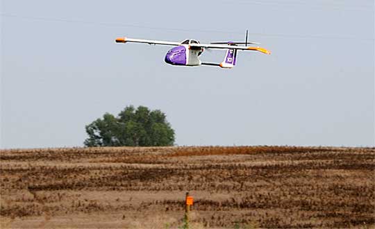
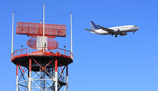
The United States Federal Aviation Administration (FAA) announced Oct. 11 that all 20,000 rebates offered to general aviation aircraft owners to equip their aircraft with Automatic Dependent Surveillance – Broadcast (ADS-B) Out have been issued and are no longer available.
Aircraft owners who have already reserved their rebate, but not claimed it yet with installation, will be allotted the specified time needed to complete the requirements for the rebate.
Image: FAA
Starting Jan. 1, 2020, ADS-B Out avionics will be required for aircraft flying in certain controlled airspace. ADS-B is a state-of-the-art surveillance system that enables air traffic controllers to track aircraft with greater accuracy and reliability.
The FAA first launched the $500 ADS-B rebate program in September 2016 to encourage owners of fixed-wing, single-engine piston aircraft to equip in advance of the Jan. 1, 2020 deadline and take advantage of ADS-B benefits.
The FAA has reiterated that the deadline will not change.
The United States Federal Aviation Administration (FAA) has awarded air carrier and operator certification to UPS Flight Forward, an unmanned aircraft system (UAS) delivery company.
Through the DOT’s UAS Integration Pilot Program, the FAA has now approved a Part 135 operating certificate for UPS Flight Forward. This allows the company to perform revenue-generating package delivery activities within federal regulations.
UPS Flight Forward may now operate multiple drones under one certificate. Under Part 135, the company can deliver vital healthcare supplies including by flying beyond visual line of sight.
The UPS subsidiary immediately launched the first drone delivery flight by any company under Part 135 Standard at WakeMed’s hospital campus in Raleigh, N.C. That flight, using a Matternet M2 quadcopter, was flown under a government exemption allowing for a beyond-visual-line-of-sight (BVLOS) operation, also a first in the U.S. for a regular revenue-generating delivery.
UPS said it has proven the need for drone delivery in healthcare operations, where the shortest time in transit can improve efficiency and help healthcare professionals better serve patients.
The medical delivery program at WakeMed is the result of testing conducted by UPS and Matternet in August of 2018 as part of their participation in the UAS Integration Pilot Program (UAS IPP).
UPS partnered with Matternet to launch its healthcare delivery service on the WakeMed campus. The revenue-generating service demonstrated the business case for drone delivery of medical products and specimens.
Now, with its Part 135 Standard certification, UPS is ready to build on this application and expand to a variety of critical-care or lifesaving applications.
Photo: UPS
“This is history in the making, and we aren’t done yet,” said David Abney, UPS chief executive officer. “Our technology is opening doors for UPS and solving problems in unique ways for our customers. We will soon announce other steps to build out our infrastructure, expand services for healthcare customers and put drones to new uses in the future.”
The company will initially expand its drone delivery service further to support hospital campuses around the country, and to provide solutions for customers beyond those in the healthcare industry.
Part 135 Standard certification enables UPS to integrate drones into the UPS logistics network, creating potential for new applications in many industries. The company has a long-term plan with milestones that include:
expansion of the UPS Flight Forward delivery service to new hospitals and medical campuses around the country.
rapid build-out of ground-based, detect-and-avoid (DAA) technologies to verify drone safety, while enabling future service expansion.
construction of a centralized operations control center.
regular and frequent drone flights beyond the operator’s visual line of sight.
partnerships with additional drone manufacturers to build new drones with varying cargo capacities.
adding new services outside of the healthcare industry, including the transport of special commodities and other regulated goods.
“UPS is committed to using technology to transform the way we do business,” said Scott Price, UPS chief transformation and strategy officer. “UPS’s formation of a drone delivery company and application to begin regular operations under this level of certification is historic for UPS and for the drone and logistics industries.”
As a participant in the U.S. Transportation Department’s Unmanned Aircraft Systems Integration Pilot Program, the North Carolina Department of Transportation (NCDOT) partnered with UPS Flight Forward. As the operator, they have been engaged in delivery of healthcare supplies around a major hospital campus in Raleigh, North Carolina. The flights have focused on the delivery of blood for potentially life-saving transfusions, as well as other medical samples for lab work.
The company demonstrated that its operations met the FAA’s rigorous safety requirements to qualify for an air carrier certificate. This is based on extensive data and documentation, as well as test flights.
Skyfront’s Perimeter 4 long-range hybrid gas-electric drone this summer successfully performed the first civilian beyond-visual-line-of-sight (BVLOS) flight without visual observers under the FAA’s Part 107 rules.
The flight serves as a significant step toward the safe integration of unmanned aerial vehicles into the national airspace, according to the company.
During the round-trip flight, the Perimeter UAV flew over mountainous, rugged terrain along a four-mile stretch of the Trans-Alaska pipeline. The UAV maintained a constant above-ground altitude of 400 feet with multiple ascents and descents of 1,000 feet on 45-degree slopes. Radio-based telemetry, command and control of the vehicle was uninterrupted during the flight.
FAA representatives observed all aspects of the mission, including planning, system setup and ground-station operation. The Perimeter “did [the flight] safely, effectively and efficiently. It accomplished a beyond-visual-line-of-sight mission, and it was approved by the FAA,” said Robert Huber, program manager for the Integration Pilot Program (IPP) of the FAA.
“Today’s flight was a milestone in the unmanned community,” said Troy Mestler, CEO of Skyfront. “We at Skyfront are excited to be pushing the limits of unmanned aerial vehicles here in the United States.”
The Perimeter UAV was integrated with Iris Automation’s Casia collision avoidance system and was observed by Echodyne’s ground-based detect and avoid systems.
The University of Alaska Fairbanks and the Alaska Center for Unmanned Aircraft Systems Integration purchased the UAV and organized the flight over the pipeline, with the approval of the Alyeska Pipeline Service Company.
Kansas receives approval for first beyond-visual-line-of-sight drone flight in the nation using only onboard detect and avoid.
The Kansas Department of Transportation (KDOT) has received permission to conduct the first beyond-visual-line-of-sight (BVLOS) drone operation in the nation leveraging only onboard detect-and-avoid systems.
This is the first U.S. Federal Aviation Administration (FAA) authorized operation to fly without a requirement for visual observers or ground-based radar. It is the result of the 31-member Kansas UAS Integration Pilot Program (IPP) team efforts to advance drone technologies.
In a collaborative effort among Kansas State University Polytechnic Campus (K-State Polytechnic), Westar Energy, Iris Automation and KDOT, the Kansas IPP team will fly a nine-mile track to evaluate technologies to inspect power lines in rural Kansas. This approval is the first of its kind for long line linear infrastructure and is the first step to enable routine commercial infrastructure inspection across the state.
This is the first unmanned aerial vehicle (UAV) flight to leverage onboard sense and avoid systems alone for collision avoidance. It also marks the first required automated avoidance action.
Historically, all FAA-issued Part 107 BVLOS waivers have required visual observers or ground-based radar. These mitigations limit the possibility of true BVLOS flights, as they are typically prohibitively expensive and limit operations to pre-defined corridor areas with radar coverage.
This important milestone is facilitated by Kansas UAS IPP partner Iris Automation’s Casia onboard collision-avoidance system.
“The UAS industry has worked over 10 years to demonstrate the most significant commercial benefit of drone operations within the United States,” said Bob Brock, KDOT director of aviation. “We are proThe Applied Aviation Research Center on the K-State Polytechnic Campus, which assisted in development of the safety case that ultimately led to FAA approval, will be responsible for the training and flight operations with a cross-functional team from the KDOT IPP. Flights will take place over the next few months, providing the FAA with much-needed data on true BVLOS activity.d of the joint state, university and industry team that made this landmark decision possible.”
“The ability to fly BVLOS missions without ground-based radar or visual observers is a significant advancement, and Westar Energy views this as an opportunity to play a key role in shaping the future of UAS operations within the utility industry,” said Mike Kelly, Westar Energy Senior UAS coordinator. “Being able to operate under this waiver allows the Kansas IPP team the ability to research and develop truly scalable BVLOS UAS operations for the automated inspection of linear infrastructure.”
“We look forward to leveraging this waiver to integrate UAS technology into the transmission line inspection process,” said Kurt Carraway, UAS Executive Director of the K-State Polytechnic Applied Aviation Research Center. “We are certain that utilities will be able to quickly realize a return on investment while mitigating safety to their maintenance personnel and increasing the reliability of their infrastructure to the general public.”
“Flying rural missions like these without a human pilot onboard or costly radar on the ground is exponentially safer and more cost effective,” said Iris Automation CEO and Co-Founder Alexander Harmsen. “The FAA is trusting us to pave the way for a safer, scalable future together with this precedent-setting second approval of our system.”
The U.S. Department of Transportation selected Kansas Department of Transportation as one of nine participants in the FAA UAS IPP. This program allows state, local and tribal governments to conduct advanced UAS operations to gather data to assist the rulemaking process that will set the boundaries for UAS operations in the United States.
The Federal Aviation Administration has added new airspace restrictions — effective July 11 — on unmanned aircraft systems (UAS) attempting to fly over national-security-sensitive locations.
The FAA has been cooperating with federal partners to address concerns about malicious drone operations by using the agency’s existing authority under Title 14 of the Code of Federal Regulations Section 99.7 (14 CFR § 99.7), Special Security Instructions, to establish UAS specific flight restrictions over select, national security sensitive locations.
The FAA’s Notice to Airmen (NOTAM), FDC 8/3277, defines these special security instructions. The FAA published a NOTAM, FDC 9/3332, which alerts UAS operators and others in the aviation community of this change and points to FDC 8/3277.
The additional 12 restricted locations requested by the U.S. Department of Defense are identified below.
Raven Rock Mountain Complex in Adams, PA
Lake City Army Ammunition Plant in Independence, MO
Pine Bluff Arsenal in White Hall, AR
Tooele Army Depot in Tooele, UT
Hawthorne Army Depot in Hawthorne, NV
Pueblo Chemical Depot in Pueblo, CO
Iowa Army Ammunition Plant in Middletown, IA
Watervliet Arsenal in Watervliet, NY
Blue Grass Army Depot in Richmond, KY
Letterkenny Army Depot in Chambersburg, PA
Rivanna Station in Charlottesville, VA
Maui Space Surveillance Site in Maui, HI
UAS operators, in particular, are urged to review the special security instructions prescribed by FDC 8/3277 and the important supporting information provided by the FAA’s UAS Data Delivery System (UDDS) website.
The UDDS website provides easy access to the text of FDC 8/3277 and other UAS-specific security NOTAMs; a current list of the airspace to which these special security instructions have been applied, supported by an interactive map and downloadable geospatial data; and other crucial details. A link to these restrictions is also included in the FAA’s B4UFLY mobile app.
The new UAS flight restrictions highlighted above and by FDC 9/3332 are pending until they become effective on 07/11/2019. UAS operators should keep in mind that access to the airspace identified by FDC 8/3277 and UDDS is strictly controlled.
Operators who violate these flight restrictions may be subject to enforcement action, including potential civil penalties and criminal charges.
The FAA is continuing to consider additional requests by eligible Federal security agencies for UAS-specific flight restrictions using the agency’s 14 CFR § 99.7 authority as they are received. The FAA will announce any future changes, including additional locations, as appropriate.
For further, broader information regarding flying drones in the National Airspace System, including frequently asked questions, please refer to the FAA’s UAS website.
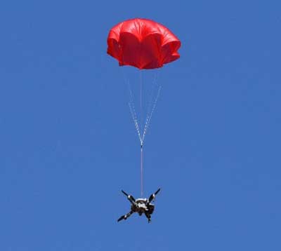
The SafeAir System is a smart parachute system that monitors UAS flight in real time, identifies critical failures, and autonomously triggers a parachute.
The ASTM F3322-18 Standard Specification for UAS Parachutes was designed to enable civil aviation authorities (CAAs), like the Federal Aviation Administration (FAA), to determine whether a parachute system is airworthy for flight over human beings.
Among other requirements, the standard defines more than 45 aerial deployment tests in various failure scenarios, verified by a third party.
ParaZero’s ASTM-compliant SafeAir Mavic is designed specifically for DJI’s Mavic 2 series. The SafeAir System is a smart parachute system that monitors UAS flight in real time, identifies critical failures, and autonomously triggers a parachute. The system contains a flight termination system, a black box to enable post-deployment analysis, and a warning buzzer to alert people below of the falling drone.
Safe UAV flights over people. The completion of the compliance process for the SafeAir Mavic will open the doors for UAS operators that are interested in the possibility of safe and legal UAS operations over people using the DJI Mavic 2. The FAA has granted a waiver for flight over people to an operator using ParaZero’s ASTM compliant SafeAir Phantom.
Photo: ParaZero
The third-party validation provided by NPUASTS — an FAA UAV test site in North Dakota — played a crucial role in the ParaZero testing. The ParaZero project is in line with the work the NPUASTS is doing to promote the safe integration of UAS into the National Airspace System.
The ability to safely operate UAS over people and in urban environments through waivers and approval is important for the growth of the UAS industry.
“Third-party validation of the SafeAir Safety System for the Mavic is a necessary step for the industry to help advance operations of small UAS in various environments,” said Nicholas Flom, NPUASTS executive director. “With the partnership from ParaZero, we are one step closer to realizing routine flight operations over persons on the ground.”
UAS operators can now purchase the ASTM-compliant SafeAir Mavic on ParaZero’s website. UAS operators will also receive compliance documentation with the purchase of the SafeAir Mavic system, including NPUASTS’ third-party testing report. This documentation and report will provide validation that operators can submit to the FAA with an operations-over-people waiver application.
“Following the precedent setting waiver announced earlier this week, we are excited to launch our second ASTM compliant SafeAir System,” said Avi Lozowick, vice president of policy and strategy at ParaZero. “We are lucky to have partners like NPUASTS for this process; their aviation experience is second to none.”
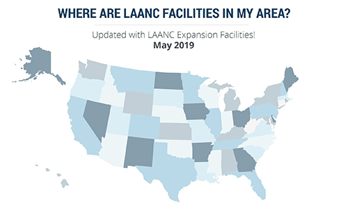
More than 100 control towers and airports have been added to the hundreds of Federal Aviation Administration (FAA) air traffic facilities and airports that currently use the Low Altitude Authorization and Capability (LAANC) system.
LAANC is a collaboration between the FAA and industry that directly supports the safe integration of unmanned aircraft systems (UAS) into the nation’s airspace.
LAANC expedites the time it takes for a drone pilot to receive authorization to fly under 400 feet in controlled airspace. By adding contract towers to the number of LAANC-enabled facilities, drone pilots will have access to more than 400 towers covering nearly 600 airports.
In less than two years, LAANC has provided fast access to controlled airspace for more than 100,000 flights, according to Matt Fanelli, director of strategy at Skyward.
Image: Skyward
“People have been asking the FAA to add more airports and today, 109 contract towers have now been added to LAANC.” Skyward has updated its 2019 LAANC Facilities Guide so that UAV pilots can easily reference airports near them that will be adding this service.
Contract towers are air traffic control towers that are staffed by employees of private companies rather than by FAA employees. LAANC provides air traffic professionals with visibility into where and when authorized drones are flying near airports and helps ensure that everyone can safely operate within the airspace.
The expansion to more than 100 contract towers means the FAA has further increased drone pilots’ access to controlled airspace safely and efficiently.
LAANC is used by commercial pilots who operate under the FAA’s small drone rule (PDF) (Part 107). The FAA is upgrading LAANC to allow recreational flyers to use the system and in the future, recreational flyers will be able to obtain authorization from the FAA to fly in controlled airspace.
For now, recreational flyers who want to operate in controlled airspace may only do so at fixed sites.
Orolia, a provider of resilient positioning, navigation and timing (PNT) solutions, announced that its SecureSync time and synchronization servers have been selected to support enroute radar systems across the U.S.
The selection comes as part of the Federal Aviation Administration’s (FAA) move towards a Next Generation Air Transportation System (NextGen). NextGen is about halfway through a multi-year investment and implementation plan.
The FAA plans to keep rolling out NextGen technologies, procedures and policies through 2025/2030 and beyond.
While NextGen will rely heavily upon GNSS to increase capacity, efficiency, and safety in the National Air Space (NAS), many technologies including legacies such as radar will be integrated into the system for maximum robustness to error and disruption.
The FAA employs a variety of radar types for short-, medium- and long-range air traffic control requirements. These diverse radars require different types of timing signals and outputs to suit their operations.
SecureSync. Orolia’s SecureSync provides the necessary timing outputs and signals to meet these requirements. The time server’s ability to provide resilient, accurate and reliable timestamps for the data that it receives from radars is used to quickly organize the data for the aircraft control user interface.
The only time and synchronization device approved by the Defense Information Systems Agency (DISA) for use in U.S. Government networks, Orolia’s SecureSync provides reliability, security and flexibility to synchronize critical aviation operations. SecureSync combines multi-GPS/GNSS signal synchronization, options for alternative signals and BroadShield GPS anti-jamming/spoofing protection for transportation systems. SecureSync combines Orolia’s precision master clock technology and secure network-centric approach with a compact modular hardware design.
The FAA selected Orolia for the competitive program based on its proven timing and synchronization technology and its ability to offer multiple output options as commercial off-the-shelf (COTS) products that do not require additional research and development time or investment.
“Consistently accurate timestamps and the synchronization of thousands of real-time flight data points are essential for safe and efficient enroute air traffic operations,” said Jean-Yves Courtois, CEO of Orolia. “Orolia is proud to support the FAA’s radar data and aircraft control user interface requirements to improve air travel services nationwide.”
More About the SecureSync COTS Product. Built-in time and frequency functions are extended with up to 6 input/output modules. Included with the base unit is a 1PPS timing signal aligned to a 10 MHz frequency signal without any 10 MHz phase discontinuity.
A variety of internal oscillators are available, depending on requirements for holdover and phase noise. On-board clocks synchronize to a variety of external references as standard, factory-installed or upgradable options.
Users may add alternate signals of opportunity to GPS or GNSS input references to improve resilience, or use them for indoor applications and choose from a variety of option cards to add to configuration of timing signals, including additional 1PPS, 10 MHz, time code (IRIG, ASCII, HaveQuick), other frequencies (5 MHz, 2.048 MHz, 1.544 MHz), telecom T1/E1 data rates, multi-network NTP and PTP. Modules can be customized for exact requirements.
To support network time synchronization, SecureSync supports the latest features of network time protocol (NTP) and precision time protocol (PTP, IEEE-1588v2). An optional multi-port NTP configuration allows for operation across 4 isolated LAN segments. Up to 6 PTP ports can be added to operate in various PTP deployments.
SecureSync is a security-hardened network appliance designed to meet rigorous network security standards and best practices. It ensures accurate timing through multiple references, tamper-proof management and extensive logging. Robust network protocols are used to allow for easy but secure configuration.
Features can be enabled or disabled based on network policies. Installation is aided by DHCP (IPv4), AUTOCONF (IPv6), and a front-panel keypad and display. The 1 RU chassis supports multi-GNSS (GPS/ Galileo/GLONASS/BeiDou/QZSS) input.
Options include SAASM, supporting L1/ L2, available for authorized users and required for the US DoD, and BroadShield GPS jamming and spoofing detection. The unit is powered by AC on an IEC60320 connector. DC as back-up, or primary, is available.
The Ohio Unmanned Aircraft Systems Center and the Air Force Research Laboratory (AFRL) will soon begin testing groundbreaking aviation technology at the Springfield-Beckley Municipal Airport.
Ohio Governor Mike DeWine, Lt. Governor Jon Husted and Major General William Cooley, commander of the Air Force Research Laboratory (AFRL) made the announcement April 26 at Wright Patterson Air Force Base.
Skyvision was developed in a collaboration between AFRL and the State of Ohio. AFRL and a delegation of Ohio UAS industry experts will showcase the SkyVision system at AUVSI Xponential in Chicago April 30 to May 2 (Booth 4226).
The SkyVision technology safely, accurately and effectively allows drones to detect and avoid other aircraft while in flight. SkyVision can be described as an air traffic control system for drones.
Inside the Skyvision RV. (Photo: Ohio UAS Center)
The validation of this aviation technology led the FAA to grant AFRL a certificate of authorization to test defense-related drone technology without reliance on a visual observer or chase aircraft.
Typically, drones can only fly within the uninterrupted line of sight of the person operating the UAS, but this special waiver allows AFRL and the Ohio UAS Center, which is part of the Ohio Department of Transportation’s DriveOhio Initiative, to use SkyVision to test drones beyond the visual line of sight (BVLOS) within a 200-square-mile parcel of unrestricted airspace near the Springfield-Beckley Municipal Airport.
“As our country steps more and more into the unmanned age of flight, this technology is on the forefront of the aviation frontier, making Ohio a critical national asset for the research and development of UAS technology,” said Governor DeWine. “This also opens the door for commercial companies to work with Ohio, AFRL, and the FAA to test their own UAS-related
technology using our SkyVision detection system. This is a major step in revolutionizing the transportation industry, with Ohio leading the way in aerospace, defense, and aviation innovation.”
“This is an important development in the progression of unmanned aircraft,” said Major General William Cooley, Commander of AFRL at Wright-Patterson Air Force Base. “This waiver provides the latitude to test beyond-line-of-sight keeping AFRL on the leading edge of world-class research and accelerates the delivery of technology that makes a difference to the warfighter.”
“By enabling our lower-altitude airspace for advanced modes of transportation, we’ll be able to facilitate new opportunities around advanced autonomous aircraft research and development,” said Lt. Governor Husted. “This will bring investment to Ohio and solidifies Ohio’s position as a world- recognized leader in aviation technology.”
Ohio’s SkyVision detection system could potentially be used by the state to develop and test UAS technology to assist citizens in the event of a natural disaster or to significantly enhance the capability of search and rescue teams to find missing persons in time-critical situations. Commercial companies, such as those looking to use drones to survey damaged infrastructure or hoping to launch drone commerce operations, will also now have incentive to move to Ohio to test their own UAS technology.
VyrtX, a company based out of Dayton, is among the first companies that has committed to expand into Springfield to work with AFRL and the Ohio UAS Center. VyrtX is currently developing technology for the potential transport of organ donations between hospitals for transplant surgeries.
UAS test flights will take place at heights ranging from 1,000 feet above ground to 10,000 feet mean sea level. Air traffic control experts from the Ohio UAS Center will operate SkyVision during each flight. The SkyVision detection system is located within a mobile unit so that it can be flexibly placed in optimum positions for each flight.
“Today’s announcement comes after years of hard work and collaboration among an incredible group of partners,” said Jeff Hoagland, President and CEO of the Dayton Development Coalition. “AFRL and Ohio had a bold vision to bring UAS into the national airspace for true beyond-visual- line-of-sight flight. The work done here will shape the industry for years to come.”
The State of Ohio and AFRL both invested a combined $5 million for the research and development of SkyVision.
Supported by the Ohio Department of Transportation, DriveOhio works to ensure Ohio’s regulatory environment and public policies are conducive to the development of the infrastructure and technologies needed for smart mobility.
Grand Sky Business and Aviation Park and Harris Corp. have joined forces to enable the country’s first and largest unmanned aerial system (UAS) airspace to support beyond visual line of sight (BVLOS) flight operations and UAS Traffic Management (UTM) research.
Stretching up to 100 miles, this BVLOS “super corridor” is the most technologically sophisticated UAS airspace supported by multiple and redundant systems for cooperative and non-cooperative surveillance.
These surveillance capabilities make possible a wide range of UAS BVLOS applications in precision farming, oil and gas, infrastructure inspection, public safety, package deliveries, and others.
“Customers of Grand Sky will have access to a truly unique UAS operational capability, in addition to better facilities, comprehensive airspace surveillance, and wide operational areas,” Grand Sky Development Co. President Thomas Swoyer Jr., said. “We all benefit from efficient and safe BVLOS flight operations and a larger corridor with proven FAA collaboration and flight authorizations.”
The surveillance system combines data feeds from a network of advanced sensors and towers. Two long-range primary radars located at Grand Forks Air Force Base and at Hillsboro, North Dakota, provide detection of non-cooperative aircraft.
The Federal Aviation Administration (FAA) secondary radars and ADS-B network in the region, as well as local Harris ADS-B Xtend sensors, add additional layers of visibility for cooperative aircrafts in the airspace.
Aviation-grade displays help pilots and electronic observers monitor the airspace environment over the BVLOS corridor and safely steer UAS from approaching manned aircraft.
The combination of best practices in aviation safety management, proven technologies and experience with BVLOS regulatory approvals will make it easy for users of the airspace to advance UAS technology commercialization and routine, efficient flight operations.
UAS operators can work with Grand Sky and Harris to develop, test, and refine a variety of complex BVLOS concepts of operations and secure waivers from the FAA for large-scale use.
A full range of UAS operations can be supported for all types and sizes of unmanned aerial vehicles along the BVLOS corridor including a variety of airspace classes and execution of diverse defense, civil and commercial applications.
“This is another first for Grand Sky and North Dakota in leading the UAS Industry,” Harris Vice President and General Manager of Commercial UAS Solutions George Kirov said. “The size and complexity of the airspace opened to UAS BVLOS operations is unmatched in the UAS industry. The sophistication of the Harris BVLOS system at Grand Sky is also unprecedented — linking Harris’ most advanced suite of surveillance and detect-and-avoid services with a variety of surveillance assets that, together, ensure the highest level of UAS aviation safety.”
This partnership lays the foundation for larger and more capable surveillance corridors to enable UAS “highways” across the state of North Dakota and in support of expanding the variety of commercial UAS operations across the United States.
New app will improve the safety and reliability of drone flights across the United States.
The Federal Aviation Administration (FAA) has partnered with Kittyhawk to redevelop B4UFLY to further its safety mission and create a new and improved mobile application to help recreational drone operators learn where they can and can’t fly.
The project is being done at no cost to the FAA.
Photo: FAA
The B4UFLY app will continue to be available to the public until the new app is deployed. The data will continue to be updated, but no new features will be added.
“We want to provide drone pilots with the best tools possible so they fly safely and responsibly,” said Acting FAA Administrator Dan Elwell. “As drone sales increase and our nation’s airspace becomes busier and more complex, it’s vital that we work smarter and partner with the private sector to develop innovative products that advance safety.”
The FAA and Kittyhawk’s Feb. 13 agreement will provide the public with a simple, easy-to-understand mobile application that provides situational awareness for recreational drone pilots. The FAA and Kittyhawk plan to launch the new app later this year.
Kittyhawk is an enterprise drone operations software company and has been an FAA Low Altitude Authorization and Notification Capability (LAANC) UAS service supplier since October 2018.
Changes to the Federal Aviation Administration (FAA) operational drone restriction were recently proposed in order to allow some flights over people. This proposed rulemaking appears to be a major step forward. Mail-order delivery flights, newsgathering, real-estate sales movies and building inspection, to name a few markets, all begin to make more sense, maybe even become viable.
Some night operations could also be possible.
Risk assessment methodology appears to be logical; a number of UAV categories are proposed, and there is a way to assess if operators are in compliance.
The Alliance for System Safety of UAS through Research Excellence (ASSURE) undertook a ground impact study to determine the possible risk of injury to people from drones falling out of the sky. Assessments were made using existing automotive standards and a military standard for debris impact, plus there was testing using automotive crash dummies.
It was a lot of work, but the bottom line appears to be that possible injuries to people are more likely to be minor than major. Bear in mind that UAS fly at relatively low altitude, are made with materials that make them somewhat elastic in nature, and that it may be possible for people in a crowd to see a flailing, falling UAV and move to avoid an impact.
Nevertheless, I do have a picture in my mind of a wayward drone crashing to the pavement after hitting a skyscraper in San Francisco, and I’m really glad I wasn’t down on the sidewalk below.
Urban building inspection using drones. (Photo:AeroSIM RC)
Then I read an article by James Poss, a retired military major, who seems to suggest that although the conclusion of the ASSURE assessment was that 2,000 grams was an OK weight for an sUAV to avoid serious injury to anyone, the FAA appears to have proposed limitations for sUAS which are only 1/10th of this weight. This is more in line with the weights in the mil-spec standard that are based on small, fast, solid-metal blast fragments.
It might help us to also consider how often or badly people are injured by golf balls, baseballs, tennis balls or squash/racket balls — for instance, I’ve survived several golf ball impacts and even an impact with a squash racket during play without major damage. These are things we all take in our stride as part of (almost) normal human activity. I wonder how often recreational enthusiasts have actually been injured during model-aircraft flying gatherings?
FAA restricts flights over government facilities
In cooperation with the Department of Justice (DOJ) and the Department of Defense (DOD), the FAA has just established temporary restrictions on drone flights within 400 feet of the lateral boundaries of a number of sensitive federal facilities. This is in addition to previous restrictions over prisons, NGA facilities, DoD ships and other facilities.
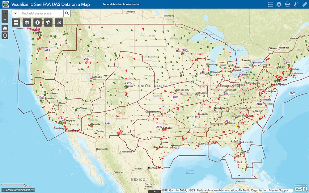
The most recent proposed Notice to Airmen (NOTAM) lists federal correctional facilities in almost half of the states in the U.S., several medical centers, U.S. Army facilities, ammunition plants and Pearl Harbor in Hawaii. It’s hard to understand why there aren’t already permanent UAV prohibitions over all such sensitive facilities across the whole U.S. I tried to check status, but the FAA UAS Data Display System didn’t list this proposed NOTAM which apparently goes into force on Feb. 26.
Think it’s probably a question of preventing bad guys from planning or doing harm rather than being shy to be caught on video — but, for sure, these places should be as secure as possible.
The FAA UAS data map shows all drone-restricted areas, once updated. (Screenshot: FAA)
Security at the Super Bowl
Well the game wasn’t the most exciting, with New England doing all that was needed to win in the fourth quarter, but the security for the event in Atlanta was humongous.
The area around the stadium was cleared of threats even before the game, attendees were screened for prohibited items and the airspace within 30 miles was restricted for general aviation and drone access. There were even Defense Department F-16 airspace patrols, and the Customs and Border Patrol had a Black Hawk helicopter available to intercept any aircraft penetrating the exclusion zone.
Nevertheless, the FAA still approved the operation of two tethered drones. One was flown close to the stadium by security personnel to provide live images of crowd movements in and around the stadium. The second system was operated at 45 meters above the rooftop of the CNN building facing the Mercedes Benz Stadium. CNN used it to provide aerial imagery of the scene before and after the game.
Elistair base station and DJI M200 at Super Bowl. (Photo: Elistair)
The tethered drone setup included two DJI M200 drones and two Elistair Ligh-T base stations, with monitoring, control and power provided to each drone by lightweight tethers. The security system was continuously operationed for 10 hours of captive flight during the Super Bowl, and for 14 hours total over two days — all while tethered to the Ligh-T control station. Security officials expressed their interest in using this solution more often because of the ability to follow a subject continuously without having to switch from one fixed camera to another, which risks losing the subject.
To sum up, new pending FAA regulations that support operations over people may have a few flaws. Other new FAA rules are aimed at protecting DOD and DOJ facilities from drone overflights, and tethered drones were used at the Super Bowl for crowd security and by CNN for color coverage.
New applications, new opportunities and preventive controls to maintain security at sensitive facilities — all moving in the right direction.