The U.S. Federal Aviation Administration (FAA) has made it easier for drone pilots to quickly and safely access controlled airspace by adding 133 air traffic facilities to the Low Altitude Authorization and Notification Capability (LAANC) system. The expansion is based on feedback from the drone community.
LAANC is an automated application and approval system for drone pilots requesting to fly below 400 feet in controlled airspace.
As the FAA continues to modernize the national airspace to accommodate more users, the agency made LAANC accessible for 726 airports and 537 facilities, covering 81% of eligible airspace.
LAANC is a collaboration between the FAA and the unmanned aircraft systems (UAS) industry which directly supports the safe integration of drones into the nation’s airspace. The service is accessible to all pilots who operate under the FAA’s small drone rule.
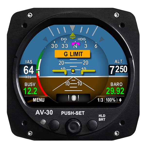
UAvionix Corporation’s aircraft AV-30-C panel display has received STC (Supplemental Type Certification) approval from the U.S. Federal Aviation Administration. The AV-30-C offers pilots an effective and affordable altitude indicator (AI) or directional gyro (DG) replacement with additional features.
AV-30-C is installable as either an AI or DG and adds a suite of in-flight information to the panel out of the box, including GPS navigational data, a probeless angle of attack indicator, baro-corrected altitude, indicated/vertical/true airspeed, non-slaved heading, bus voltage, G load and more with additional features to be announced.
AV-30-C is designed to fit into nearly any aircraft with a three and one-eighth inch round instrument slot without cutting or modifying the panel. By mounting from behind the panel, AV-30-C preserves the aircraft’s original classic look while bringing the latest that modern avionics has to offer to the panel.
The AV-30-C STC provides authorization to install in FAR Part 23 Class 1 and Class 2 aircraft (singles and twins weighing less than 6000 lbs) that are listed on the AV-30-C Approved Model List (AML), containing 635 Aircraft models including Cessna, Piper, Beechcraft, American Champion, Maule, Boeing, Swift, Mooney, Aviat and others. The full AML is available at uAvionix.com/AV-30.
AV-30-C works as a single primary instrument or by installing two units, one as an AI and another as a DG. The aircraft’s original failure-prone vacuum pump system can be removed to further benefit from a fully digital primary instrument cluster.
AV-30-C extends its functionality outside the cockpit as the companion to tailBeaconX, the latest 1090/ES ADS-B transponder with Aireon support for worldwide use and future mandated airspaces. Upon tailBeaconX TSO certification, AV-30-C can double as tailBeaconX’s control interface, allowing the pilot to set the mode and squawk easily, while maintaining AV-30’s existing feature set. tailBeaconX with AV-30-C removes the need to drill additional holes in the airframe to satisfy requirements in countries outside the U.S. and keeps installation costs to a minimum.
“uAvionix is creating avionics with fundamental engineering advantages,” said COO, Ryan Braun. “These are beautiful, no-compromise certified avionics designed to deliver an affordable total cost of ownership. The AV-30-C provides an innovative probeless angle-of-attack and non-slaved directional gyro, both designed to dramatically lower the cost of installation without compromising performance. Where other avionics seem designed to be replaced, the AV-30-C will get better with age. We’re actively developing ADS-B In, electronic flight bag, transponder, and autopilot integrations to ensure AV-30-C becomes an indispensable instrument for every panel.”
AV-30-C will support third-party autopilot systems via the APA-MINI adapter, interfacing AV-30’s heading bug with legacy autopilots. The APA-MINI autopilot adapter is expected to be released in early 2021, with more advanced autopilot integrations to follow.
The Federal Aviation Administration (FAA) plans to evaluate technologies and systems that could detect and mitigate potential safety risks posed by unmanned aircraft. The effort will be a part of the agency’s Airport Unmanned Aircraft Systems Detection and Mitigation Research Program.
The FAA Reauthorization Act of 2018 requires the agency to ensure that technologies used to detect or mitigate potential risks posed by unmanned aircraft do not interfere with safe airport operations.
The FAA plans to test and evaluate at least 10 technologies or systems. The evaluations are expected to begin later this year and will initially occur at the FAA’s William J. Hughes Technical Center, located next to the Atlantic City International Airport in New Jersey.
After the initial testing and evaluation in New Jersey, the agency expects to expand the effort to four additional U.S. airports. Those selections will be made at a later date.
According to the FAA, interested manufacturers, vendors and integrators of drone detection and/or mitigation technologies/systems will have 45 days to respond to its announcement.
In addition, the FAA expects to issue another solicitation in the coming weeks for airport operators interested in hosting the additional research and testing.
The Federal Aviation Administration (FAA) has awarded $3.3 million in research, education and training grants to universities that comprise the FAA’s Air Transportation Center of Excellence (COE) for Unmanned Aircraft Systems, also known as the Alliance for System Safety of UAS through Research Excellence (ASSURE).
“These grants will help develop a greater array of innovative strategies to more effectively deploy drones during emergency response situations,” said U.S. Transportation Secretary Elaine Chao.
The FAA’s CEO program, authorized by Congress, is a long-term, cost-sharing partnership between academia, industry and government. The program enables the FAA to work with center members and affiliates to conduct research in airspace and airport planning and design, environment and aviation safety, FAA said.
Mississippi State University received the Alliance for System Safety of UAS through ASSURE Program Management grant for $1,290,410. This grant is for the ASSURE lead university to provide overall program management. This program management will include tracking of financial information for all core university project activities; reviewing and vetting of all project related documentation prior to submission to the FAA; hosting and facilitating all FAA-required meetings; and outreach to government, industry and academia, FAA said.
Six universities, including the University of Alabama–Huntsville ($1,101,000), New Mexico State University ($234,000), the University of Alaska, Fairbanks ($245,000), Mississippi State University ($130,000), North Carolina State University ($124,979) and Oregon State University ($165,000) received grants for Disaster Preparedness and Response (Phase I and II, as directed by Congress). According to FAA, this research will provide insight into the safe integration of UAS into the disaster preparedness and response areas. This research will look at how UAS can aid in disaster preparedness and response to different natural and human-made disasters. It will focus on procedures to coordinate with the Department of Interior, the Department of Homeland Security, the Federal Emergency Management Agency and other federal, local and state organizations to ensure proper coordination during those emergencies.
There are currently 1.65 million recreational and commercial drones in the active UAS fleet. That number is expected to grow to as high as 2.31 million by 2024, FAA reported. The ASSURE grants are aimed at continuing the safe and successful integration of drones into the nation’s airspace.
“Collaboration is hugely important as we work to safely integrate UAS into the aerospace system,” said FAA Administrator Steve Dickson. “These important grants fund the research which allows us to learn and implement the safety measures associated with UAS operations in the airspace.”
The COE universities received a total of $3.3 million to advance specific goals and projects. This is the second round of ASSURE grants. The grants listed above will bring the fiscal year 2020 total for this COE to $5.8 million.
A Loyal Wingman drone rolls out, the U.S. Air Force (USAF) sponsors air taxi-cargo UAS development, and medical deliveries take place in Scotland and Florida — we have quite a wide selection for this month’s news.
Fighter support drone
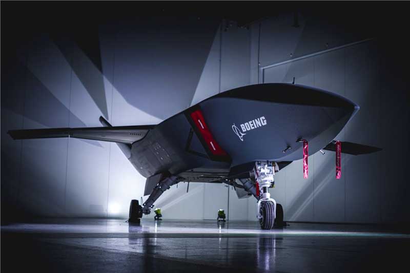
Boeing Loyal Wingman prototype (Photo: Boeing)
Boeing Australia has just rolled out the first “Loyal Wingman” for the RAAF (Royal Australian Air Force) — in essence what looks like a completed first article of three prototypes on order for Australia’s Loyal Wingman Advanced Development Program.
The concept is to develop an “inexpensive, expendable” UAV which will fight alongside today’s frontline fighter aircraft, controlled from the ground or from the air. A “force-multiplier” which doesn’t risk either pilot or the heap-expensive interceptor/ground attack aircraft themselves, a real bonus for smaller air-forces, and a less costly way of increasing numbers.
The first prototype will now go into a ground and flight test program to prove out systems and flight capabilities – first flight would likely be later this year.
A team of 35 Australian aerospace companies are supporting the Loyal Wingman project, including BAE Systems Australia which has been selected to supply the flight vehicle management system, flight control computers and navigation equipment.
Flying cars?
The U.S. Air Force wants a fleet of them by 2023!
So in a novel way to stir interest in the concept of flying cars, or perhaps cargo carrying drones, the Air Force launched a program known as “Agility Prime.” The program may have begun conventionally with seed contract(s) to drone manufacturers, but their latest “webcast” approach provided an extensive overview of what this could mean to the U.S. industry.
From April 27 through May 1, a panel including Air Force leaders, two U.S. Senators, NASA and Federal Aviation Administration management, and key Air Force and Defense Department players participated in an open presentation to industry, investment and State Government participants — all with the aim of accelerating civilian development of “advanced air mobility vehicles.”
Recognizing that a principle problem is overcoming regulatory hurdles, USAF intends to provide a route to commercial revenue service such as logistics transport and disaster recovery by perhaps providing access to its key testing capabilities and facilities. With broad participation in the program by industry, government and investors (i.e. USAF don’t intend to pay for it all) the program would satisfy an operational safety and security baseline and provide a platform for the “Race to Certification” of commercial drone product(s) the USAF might also want to buy.
One of the possible solutions for a cargo drone already funded includes the Sabrewing Cargo Drone – known currently as Rhaegal-A.
Four electric powered ducted fans rotate for Vertical Take-Off and Landing (VTOL) and are powered by a Safran (French) Ardiden 3 helicopter turbine engine – giving this large UAV a design speed of 245 mph, a ceiling of 20,000 feet and range of 1000 miles.
Sabrewing has received $3.25m under a two year USAF sponsored Small Business Incentive Research (SBIR) project in the hope that the design could be eventually adapted to military logistics applications. The vehicle is intended to be able to fly autonomously, has detect and avoid capability, and can even operate when GPS is continuously jammed — something the military would probably appreciate. Potential casualty evacuation is also of great interest.
Medical supplies delivery
Meanwhile in the U.K., in cooperation with the U.K. Civil Aviation Authority (CAA), Skyports drone company is playing in the CAA’s “Sandbox.” This is another term for an umbrella/sequence of trials under CAA safety and security constraints where innovative approaches are given a chance to demonstrate that new aviation related things are possible, that they actually work and that they meet the CAA criteria. Skyports wants to test out Beyond Visual Line of Sight (BVLOS) operations for its upcoming trial of medical deliveries between Oban and Mull off the West Coast of Scotland.
As front-line health professionals fight to beat the COVID-19 pandemic, deliveries of essential medical supplies between medical facilities can be speeded-up significantly using drones. Skyports will begin the week-long trial between Mull and Oban medical centers in the last week of May.
The planned BVLOS flights will be over a 17-mile route in unrestricted airspace and avoid the Oban airport, crossing the narrow sea channel and onto the North coast of the Isle of Mull. Skyports already has experience transporting medical and other high-value cargo in other parts of the world. The candidate drone is equipped with Iris Automation Casia detect-and-avoid computer vision system, and Thales Remote ID, and the Skyports drone team is also supported by Thales SOARIZON flight management and mission planning system.
Drones to deliver prescriptions
And finally, something quite helpful during the current coronavirus pandemic — CVS and UPS having linked up some time ago, are to begin delivering prescription medication to customers in Florida. The process has been previously checked out during November last year trials in Cary, N.C.
UPS will use the Swiss Matternet M2 delivery drone, picking up medication at specific CVS location(s) and flying it to a delivery point at “The Villages” in Central Florida, then the “last-mile” delivery is by road — presumably by an outfit which knows the layout of this huge facility where something like 130,000 retirees live. Useful during this phase of Florida’s self-quarantine for elders who may find it difficult to get out to the drug store. Hope they start running the same service out of my local CVS.
Wrap-up
So from the extreme military application of drone support for fighter attack missions, and USAF sponsored development of air-taxis and cargo drones, through to medical supply deliveries by drone in remote areas of Scotland and prescription deliveries in Florida — activity never seems to abate in this growing industry.
The Federal Aviation Administration (FAA) and the Association for Unmanned Vehicle Systems International (AUVSI) will host the 5th annual FAA UAS Symposium virtually, rather than in-person in Baltimore. The event will take place June 16-18.
This decision was made as a result of the ongoing concerns caused by the COVID-19 pandemic, the organizers said.
The FAA and AUVSI also will be hosting a series of virtual events that will address the content already planned for this year’s program. The fist will take place in early summer and will focus on UTM and international UAS integration. The second will take place in late summer with a focus on updates to the Integration Pilot Program and public safety operations.
According to organizers, those registered for the 5th annual FAA UAS Symposium will receive a separate message in the coming weeks to confirm options for participation in the virtual events.
Those selected as speakers for the 5th annual FAA UAS Symposium will receive a separate message from AUVSI’s Industry Education Team to confirm participation, as well as any schedule changes.
Image: 4X-image iStock / Getty Images Plus / Getty Images
Nearly 4,000 waivers granted under Part 107; about 20 percent of waivers granted to organizations received by first responders
Almost four years after the Federal Aviation Administration (FAA) established rules for the commercial operation of small unmanned aircraft systems (UAS), a new report by the Association for Unmanned Vehicle Systems International (AUVSI) found that nearly 4,000 operators across all 50 states have been granted waivers to go beyond current regulations.
First responders across the country received about 20 percent of all waivers granted to organizations (398), which demonstrates growing interest and need for public safety applications enabled by UAS, including search and rescue and firefighting at night.
Effective Aug. 29, 2016, the small UAS rule, also known as Part 107, created a uniform regulatory framework for UAS. Among the rule’s requirements, UAS must fly below 400 feet above ground level (AGL), within visual line of sight and during daylight hours.
Recognizing the need for the rule to be flexible to foster innovation, the FAA created a waiver process that allows for expanded types of operations, such as nighttime or beyond line of sight operations, with the approval of the agency.
AUVSI analyzed 3,946 of these waiver documents granted by the FAA since Part 107 went into effect. While the vast majority of waivers (3,636 or 92 percent) were granted to waive the requirement for flying only during the daytime to enable nighttime operations, the FAA has also granted waivers from other sections of the regulations to permit advanced operations, including:
Flights over people (112 waivers);
Operation in certain airspace (97 waivers);
Operating multiple UAS at the same time (55 waivers);
Visual line of sight operations (to enable beyond line of sight operations) (51 waivers).
Operators in all 50 states, as well as the District of Columbia and Puerto Rico, have received waivers. California leads the way with 451 waivers granted, followed by Texas (334), Florida (272) and New York (159). About 87 percent of all waivers were granted to small businesses with fewer than 10 employees and annual revenues of less than $1 million.
“Across the country, operators have demonstrated they are eager to harness the tremendous potential of expanded UAS operations,” said Brian Wynne, president and CEO of AUVSI. “Small businesses have been able to save time and money, and first responders and public safety agencies have used UAS technology to increasingly contribute to the greater good worldwide, supporting missions from disaster relief to humanitarian aid.”
Last month, AUVSI submitted its comments on the FAA’s Notice of Proposed Rulemaking (NPRM) for Remote Identification of UAS. In the comments, AUVSI urged the FAA to proceed concurrently with rulemaking that would allow for expanded operations rather than wait for a fully implemented remote ID rule to avoid unnecessary delays. The FAA says it hopes to issue a final rule before the end of the year.
In the interim, the FAA recently announced several initiatives to improve the waiver application process in response to a review last year of the waiver framework by a task group of the Drone Advisory Committee that was chaired by Wynne.
The FAA’s plans include expediting the waiver renewal application process, particularly in instances where there hasn’t been many changes since the original application; enabling quick administrative changes to previously granted waivers; providing more responsive feedback to applications that were not approved; streamlining the applications; implementing new regulations to obviate the need for waivers; and increasing transparency and accountability to provide support for waiver applications, disapprovals, and general UAS questions.
“The waivers that have been granted so far demonstrate that operators are safely able to conduct expanded operations, such as flights over people and beyond visual line of sight,” said Wynne. “While improvements to the waiver process are needed and welcomed, we urge the FAA to move forward rapidly with rulemakings that would enable these operations widely and provide the economic and societal benefits they offer.”
The UAV market has been growing rapidly for the past several years, especially in the U.S. with the Federal Aviation Administration (FAA) Part 107 regulations becoming active in August 2016. Before then, it was impossible to tell what systems were real and would weather the marketplace, and which were just a dream. Multicopters dominate the marketplace. (DJI’s M600 — out since 2016 — offers a 1–6-kilogram payload option). In late 2019, InnoFlight introduced the Galaxy 950 unmanned helicopter, a single-rotor platform capable of carrying more than 6 kilograms. It is available with battery power only, providing flights under an hour, but soon will support a gas-driven option for flights exceeding 2 hours. The system can be ready to deploy in less than 10 minutes.
Lidar USA provides a range of available lidar systems weighing about 5 kilograms, which work well with heavy-lift systems such as the Galaxy 950. In 2019, the Optech CL-90 was released; later the same year, the CL-360 hit the market. Lidar USA integrated each scanner into its product family and immediately saw the possibilities with the Galaxy 950.
The Lidar USA CL-series, together with the Galaxy 950, easily falls in the under-55-pound category set by the FAA. This means users can tackle small (5-acre) and large (500- to 5,000-acre) mapping jobs with confidence in their drone platform, the quality of the scan data, and the resulting lidar point cloud. The Galaxy 950 can easily support the CL-series with supporting cameras. The Optech CL-series provides survey-grade lidar accurate data: +/– 0.01 foot from a car on a paved surface. The system can operate from 400 feet with scan lines every inch at speeds of 14 mph (6.3 m/s). Of course, not all pulses make it to the ground due to vegetation, but the Optech CL-series provides up to four echos per pulse with a small beam size of 0.3 milliradians. Depending on the clipping angle, the scan width can range upwards of 1,200 feet, equating to about 34 acres per minute along a corridor. This system provides the surveyor with high-quality, accurate and dense lidar data.
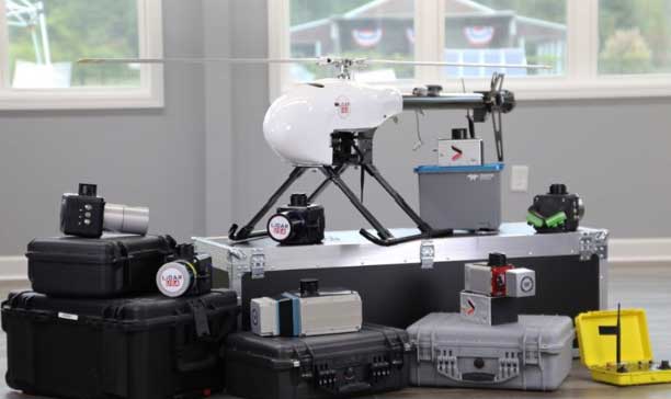
NASA Langley opened registration for its Safeguard with Autonomous Navigation Demonstration (SAND) Challenge, which will be held May 2020 in Hampton, Virginia. According to NASA Langley, the SAND Challenge will be an opportunity for small businesses to compete in an autonomous unmanned aerial vehicle (UAV) competition.
The challenge will address some of the safety critical risks associated with flying UAVs in the national airspace system.
NASA released the competition scenario, which reads: Hampton, Virginia, was hit by a large and devastating hurricane. The effect of the hurricane was to flood much of the area, knock down trees, damage houses/buildings, disrupt power lines and cause some injuries to residents. As part of the recovery effort, crews are working to locate incapacitated people, assess the damage to neighborhoods, look for downed power lines and determine the extend of the remaining flooding. To meet those objectives, both manned and unmanned aircraft are being leveraged to expedite the response. The Concept of Operations employed assumes UAS will remain within a specific volume of airspace to ensure the safety of unmanned aircraft operating in the vicinity, as well as the safety of first responders that are working in adjacent zones. UAS are assigned to specific areas to perform search and surveillance efforts. Safeguard provides range containment for vehicles independent of the UAS operator’s ability to monitor the vehicle, either by direct line of sight or through telemetered data. Its use for SAND is similar to beyond visual line of sight applications.
NASA Langley’s patented Safeguard technology will be used to help small business competitors mitigate such risks while they complete a set of complex mission profiles. For this competition, it will be configured to warn competitors (and auto-pilots) of impending excursions (or violations) while also objectively measuring performance with respect to the rules of the competition. The challenge will follow the Federal Aviation Administration Part 107 Regulation Small Unmanned Aircraft Regulations.
The Federal Aviation Administration (FAA) and Association for Unmanned Vehicle Systems International (AUVSI) will co-host the 5th Annual FAA Unmanned Aircraft Systems (UAS) Symposium June 16-18 in Baltimore. The event will take place at the Baltimore Convention Center.
The symposium will bring together representatives from the FAA, other government agencies, the industry and academia. According to the show organizers, the presenters and panelists will discuss the latest information and advancements related to the diverse uses of unmanned aircraft, and how these new entrants are being safely integrated into the National Airspace System.
The show will include four primary educational tracks, including public safety, technology and innovation, international and policy. The public safety track will explore topics such as addressing community concerns, security, and using drones to conduct safer and more effective public safety missions. The technology and innovation track will cover how drones and drone technologies are innovating rapidly and fundamentally changing aviation. The international track will feature discussions on how national and international UAS experts, industry representatives, civil society stakeholders, non-governmental organizations and policy makers are working to integrate and use drones across the globe. Finally, the policy track will allow attendees to hear directly from policy decision makers and get their thoughts on regulatory, operational and technical concerns.
In addition, the FAA will operate as an on-site resource center to answer questions from UAS owners and operators. Subject matter experts will be on hand to answer questions about airspace authorizations, waivers, the Part 107 small UAS rule, changes in hobbyists’ drone operations, the Remote Identification rulemaking, and other policies and regulations, the organizers added.
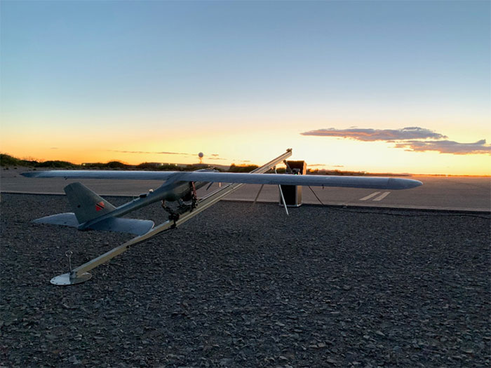
According to the company, the E1 is a solar electric, fixed wing unmanned aircraft system. It has a 20-pound payload capacity and a ceiling of 20,000 feet above ground level. It’s ideal for consumers who do not have the expertise to operate their own UAS, as SFUAS provides full service as well as sales, the company said.
The Silent Falcon E1 features 12 different sensor types, is vibration free and is beyond visual line of sight capable with a live feed. It also boasts four- to 12-hour duration configurations.
In addition, Silent Falcon has an application pending before the Federal Aviation Administration for type certification of the E1.
“Successfully passing 500 hours of flight is a significant milestone for the E1, confirming for federal regulators that it is a safe and durable aircraft model,” Silent Falcon said in a press release.
The full line of SFUAS products, services and support is now available via GSA Contract No. GS07F248BA, the company added.
At any given moment, more than 5,000 airplanes are flying over the United States. In a single year, nearly 778 million passengers will take to the skies — more than twice the population of the U.S., and the number increases each year. Aviation is the safest form of transportation. It is 100 times safer than driving. For every 100 traffic deaths, only one aviation related fatality occurs; and the Federal Aviation Administration (FAA) is working hard to make aviation even safer.
Safety is the FAA’s primary focus. The FAA Strategic Plan FY 2019– 2022 states its mission is to provide the safest, most efficient aviation system in the world. To achieve this goal, the FAA is implementing several initiatives. The technical aspects of these efforts fall under a framework called NextGen designed to modernize the nation’s air traffic control system. NextGen began in 2003 in the VISION 100 – Century of Aviation Reauthorization Act. At its core, NextGen is a geospatial framework with satellite navigation as its backbone.
The Geospatial Data Act (GDA) became law when President Trump signed the FAA Reauthorization on Oct. 5, 2018. You might have wondered how the GDA came to be included in the bill. It makes sense in the context of technology advancements towards a smart transportation network, specifically in aviation.
The smart transportation concept integrates all forms of transportation to provide economic and environmental benefits as well as increase safety and reduce wait times and congestion. A large part of smart transportation is based on geographic information technology. The aviation component of this smart transportation initiative falls within the FAA’s authority under the overarching framework named NextGen.
NextGen is an integrated concept improving the efficiency and safety of flight operations both on the ground and in the air. The use of geospatial technology enables precision time-management for controlling air traffic. The system allows each airplane to digitally coordinate with other aircraft in the area, taking into account such things as terrain and other known hazards to safely reroute air traffic as necessary. The FAA refers to this as trajectory-based operations. Those with a knowledge of GIS will recognize it as four dimensional: it calculates direction, speed, distance and time relative to position in x-y-z, and coordinates that information with other known data. Additionally, the system uses historical flight data and predictive analytics to maximize airspace for routing air traffic such as what is experienced during the holidays.
NextGen also uses a system called Optimal Profile Descents (OPD), which allows an airplane to trim its engines and descend along a glide slope from flight level into the airport. The point at which a plane begins its descent is a geospatial calculation to determine the precise point in space for the airplane based upon its altitude, weight, glide slope and distance to the airport. The benefits of OPD are reduced engine noise, fuel savings, less carbon emissions and a positive economic impact. NextGen is an across-the-board win for the airline industry, airline passengers, the economy and the environment.
According to an interview with Michael Whitaker, former deputy administrator of the FAA who was the Chief NextGen Officer, NextGen revolutionizes aviation by enabling digital data communication. It replaces radar-based navigation and tracking with satellite-based air traffic control. The cornerstone of NextGen is the Automated Dependent Surveillance Broadcast (ADS-B) system.
ADS-B is an aviator’s version of Waze, but with a lot more information. ADS-B(out) broadcasts an airplane’s Flight ID, ICAO Code, speed and location in three-dimensional space to air traffic controllers and to everyone who is equipped with ADS-B(in). The combination of ADS-B(out) and ADS-B(in) greatly increases situational awareness for aviators. On Jan. 1, 2020, all airplanes operating in controlled airspace needed to have ADS-B(out) installed. ADS-B transforms the entire National Airspace System into a satellite-based geospatial network. It integrates multiple sources of real-time data, such as weather, pilot reports, aircraft positions, 3D airspace information, and other sources of data, which can be overlaid on top of various basemaps and terrain elevation models, allowing pilots to make more informed and safer decisions.
Switching to ADS-B opens up more capacity in already crowded skies by decreasing the required vertical and horizontal separation distances between aircraft. At Hartsfield-Jackson International Airport, the busiest airport in the world, changing to performance-based operations allowed 8 to 12 more departures per hour; and in Memphis International Airport, one of the busiest airports for cargo operations, arrivals increased by 20%.
Rune Duke, senior director of government affairs, Airspace, Air Traffic and Aviation Security for the Aircraft Owners and Pilots Association (AOPA), said that ADS-B will allow much faster update rates for air traffic controllers on the order of once every second, compared to legacy radar systems that report positions every 8 to 12 seconds. For an airplane traveling at 350 knots, that is about 1 mile. A lot can change in a mile in densely packed airspace.
If you are reading this because of your love of maps and aviation, then I highly recommend the FlightAware and ForeFlight smartphone apps. FlightAware turns the phone into an ADS-B(in) receiver showing the location and flightpath of each aircraft in the immediate area on a basemap. I sit on my back deck and watch airplanes coming and going because I live under the flightpaths for Dulles International Airport, Reagan International Airport, Leesburg Executive Airport, the Montgomery County Airpark and the TERPZ waypoint. On occasion I see helicopters flying to Camp David because I am under that flight path as well.
So, I get to see a variety of aircraft. You can select the airplane icon to see information such as aircraft type, airline, Flight ID, departing and arrival airports, altitude, and groundspeed. Even more information is available by selecting the pop-up window. This is ADS-B information. ForeFlight, on the other hand, is a pilot’s flight bag on a tablet.
In the future, ADS-B will integrate Aircraft Hazardous Areas (AHA): temporary no-fly zones due to commercial space launches. Because of ADS-B, planes will automatically reroute around the AHA, and when the AHA expires, airplanes will be routed back through the area.
ADS-B supports evolving technologies such as remote towers, another significant change to air traffic control. Remote towers allow air traffic controllers to be at a location other than the actual airfield. Remote towers use a suite of sensors mounted at the airfield, including high-definition video, thermal and night vision that can be combined with the digital information provided by ADS-B, all of which is displayed on widescreen panels in a room duplicating the experience of being at the airport and directing aircraft. This allows smaller airports that cannot afford the huge expense of building and staffing an air traffic control tower to be part of a remote tower network. One remote tower center will be able to support several airfields. Leesburg Executive Airpark recently finished successful testing of one of the first remote tower operations in the United States.
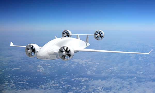
“Over the next 10 years, we are going to see logistics and transportation open up, from being limited by currently rigid road infrastructure to operating on fully flexible and responsive aerial transportation networks,” said Patrick Watson, director of business development for Animal Dynamics.
The envisioned Platform Unmanned Cargo Aircraft. (Photo: PUCA)
ADS-B will also support the integration of unmanned aerial systems (UAS) into the airspace, specifically unmanned cargo aircraft (UCA). In the not too distant future, carrier air fleets without pilots or aircrew will be taking to the skies. UCAs do not require crews, so there will be no need for water, toilets, sewage containment, kitchens or a cockpit (in the traditional sense). Taking those out will allow for more space in the plane to carry cargo and fuel. Plus, without crews on board, there will be no time restrictions on crew hours — planes will be able stay aloft longer and travel further. ADS-B greatly enables the success of this technology.