The U.S. Department of Transportation’s Federal Aviation Administration issued a proposed rule that would require unmanned aircraft systems (UAS) to be identifiable remotely.
The rule, deemed the “Notice of Proposed Rulemaking for Remote Identification,” would apply to all drones that are required to register with the FAA (recreational drones weighing under 0.55 pounds are not required to register), as well as to persons operating foreign civil UAS in the U.S.
“Remote ID technologies will enhance safety and security by allowing the FAA, law enforcement and federal security agencies to identify drones flying in their jurisdiction,” said U.S. Transportation Secretary Elaine Chao.
According to the FAA, nearly 1.5 million drones and 160,000 remote pilots are registered with the administration. Equipping drones with remote identification technologies would build on previous steps taken by the FAA and the UAS industry to safely integrate operations, including the small UAS rule, which covers drones weighing less than 55 pounds, and the Low Altitude Authorization and Notification Capability, which automates the application and approval process for most UAS operators to obtain airspace authorizations, the FAA added.
“As a pilot, my eye is always on safety first,” said FAA Administrator Steve Dickson. “Safety is a joint responsibility between government, pilots, the drone community, the general public and many others who make our nation so creative and innovative.”
The proposed rule will be accompanied by a 60-day comment period to receive public feedback and help the FAA develop a final rule to enhance safety in the skies over the U.S.
uAvionix has received U.S. Federal Aviation Administration (FAA) approval for the Vehicle Tracking Unit (VTU-20) Automatic Dependent Surveillance – Broadcast (ADS-B) transmitter for airport surface management.
uAvionix is a designer and manufacturer of communications, navigation and surveillance (CNS) equipment for unmanned and manned aircraft.
Adhering to the performance and design assurance specifications of FAA-E-3032, the externally mounted VTU-20 ensures integration and interoperability with Airport Surface Detection Equipment, Model X (ASDE-X), Airport Surface Surveillance Capability (ASSC) and ADS-B receiver surveillance solutions for airport
surface control and situational awareness.
The VTU-20 can be permanently or magnetically mounted to all airside vehicles, including utility, emergency, snow-removal and maintenance equipment. Each vehicle is clearly and uniquely identified, providing an essential addition to any surface movement guidance and control system.
The VTU-20 implements FAA-approved Squitter Transmission Maps to automatically enable transmission on airport movement areas and disable transmission in low-risk areas or outside airport airside operations.
“Ground vehicle incursions into critical safety and movement areas is on the rise. With this achievement, uAvionix continues to promote safety and common situational awareness not only in the airspace but also on the airport surface,” states Christian Ramsey, uAvionix president.
This recent uAvionix achievement will be made available through an exclusive relationship with L3Harris Technologies, Inc., a leader in surveillance and air traffic management known for the Symphony product line of airport operations and environmental compliance solutions — to promote and sell the VTU-20 in the United States.
Guest column by Brian Wynne AUVSI President and CEO
Brian Wynne, AUVSI president and CEO
A recent analysis found that just 10 percent of the unmanned aircraft systems (UAS) included in the Unmanned Systems and Robotics Database maintained by the Association for Unmanned Vehicle Systems International (AUVSI) can operate beyond the visual line of sight (BVLOS) of its operator.
While the technology for BVLOS operations has existed for years, under current federal regulations, only the military is permitted to use it. The absence of federal regulation allowing BVLOS operations hinders the full value and benefits that the UAS industry has to offer.
Regulations that provide guidance and rules for operating unmanned systems are necessary for the industry’s advancement. Earlier this year, the Federal Aviation Administration (FAA) issued a proposed rule for UAS operations over people, and the UAS community is eagerly anticipating the agency will offer an additional rule requiring UAS to be equipped with remote identification.
“Remote ID is a crucial next step to gain the confidence of federal defense and security agencies, manned aviation users and the public.”
However, the rulemaking process for remote ID has been delayed by the FAA twice this year and is now slated to be released in December. The need for remote ID cannot be overstated, as the advancement of the UAS industry depends on identifying and tracking UAS flying in the airspace.
Furthermore, remote ID is a crucial next step to gain the confidence of federal defense and security agencies, manned aviation users and the public. With this confidence, UAS can further integrate into the national airspace to perform important BVLOS operations such as inspection of utility rights of way, widespread search-and-rescue missions, and package delivery.
A clear, national regulatory framework and the support of the federal government is needed to drive the adoption of unmanned systems technology and its applications. Currently, the UAS industry is working with our government partners on remote ID and tracking standards, but we recognize that more needs to be done and at a faster pace than the regulatory process allows. That is why the UAS industry is stepping up to explore near-term solutions before remote ID regulations are finalized and published.
In May, AUVSI and the Airports Council International-North America commissioned a Blue Ribbon Task Force on UAS Mitigation at Airports. The task force is working to refine procedural practices and provide a policy framework to address the timely and critical issue of incursions by unauthorized UAS at airports and how best to mitigate this threat, including industry and government recommendations for remote ID. The task force will release a report this year.
Applications of unmanned systems aren’t limited by technology or imagination; they’re only limited by regulations. We need a streamlined regulatory environment that allows for the safe deployment of unmanned systems into our nation’s transportation infrastructure so we can begin to reap the full benefits of this technology.
The United States Federal Aviation Administration (FAA) announced Oct. 11 that all 20,000 rebates offered to general aviation aircraft owners to equip their aircraft with Automatic Dependent Surveillance – Broadcast (ADS-B) Out have been issued and are no longer available.
Aircraft owners who have already reserved their rebate, but not claimed it yet with installation, will be allotted the specified time needed to complete the requirements for the rebate.
Image: FAA
Starting Jan. 1, 2020, ADS-B Out avionics will be required for aircraft flying in certain controlled airspace. ADS-B is a state-of-the-art surveillance system that enables air traffic controllers to track aircraft with greater accuracy and reliability.
The FAA first launched the $500 ADS-B rebate program in September 2016 to encourage owners of fixed-wing, single-engine piston aircraft to equip in advance of the Jan. 1, 2020 deadline and take advantage of ADS-B benefits.
The FAA has reiterated that the deadline will not change.
Changes to the Federal Aviation Administration (FAA) operational drone restriction were recently proposed in order to allow some flights over people. This proposed rulemaking appears to be a major step forward. Mail-order delivery flights, newsgathering, real-estate sales movies and building inspection, to name a few markets, all begin to make more sense, maybe even become viable.
Some night operations could also be possible.
Risk assessment methodology appears to be logical; a number of UAV categories are proposed, and there is a way to assess if operators are in compliance.
The Alliance for System Safety of UAS through Research Excellence (ASSURE) undertook a ground impact study to determine the possible risk of injury to people from drones falling out of the sky. Assessments were made using existing automotive standards and a military standard for debris impact, plus there was testing using automotive crash dummies.
It was a lot of work, but the bottom line appears to be that possible injuries to people are more likely to be minor than major. Bear in mind that UAS fly at relatively low altitude, are made with materials that make them somewhat elastic in nature, and that it may be possible for people in a crowd to see a flailing, falling UAV and move to avoid an impact.
Nevertheless, I do have a picture in my mind of a wayward drone crashing to the pavement after hitting a skyscraper in San Francisco, and I’m really glad I wasn’t down on the sidewalk below.
Urban building inspection using drones. (Photo:AeroSIM RC)
Then I read an article by James Poss, a retired military major, who seems to suggest that although the conclusion of the ASSURE assessment was that 2,000 grams was an OK weight for an sUAV to avoid serious injury to anyone, the FAA appears to have proposed limitations for sUAS which are only 1/10th of this weight. This is more in line with the weights in the mil-spec standard that are based on small, fast, solid-metal blast fragments.
It might help us to also consider how often or badly people are injured by golf balls, baseballs, tennis balls or squash/racket balls — for instance, I’ve survived several golf ball impacts and even an impact with a squash racket during play without major damage. These are things we all take in our stride as part of (almost) normal human activity. I wonder how often recreational enthusiasts have actually been injured during model-aircraft flying gatherings?
FAA restricts flights over government facilities
In cooperation with the Department of Justice (DOJ) and the Department of Defense (DOD), the FAA has just established temporary restrictions on drone flights within 400 feet of the lateral boundaries of a number of sensitive federal facilities. This is in addition to previous restrictions over prisons, NGA facilities, DoD ships and other facilities.
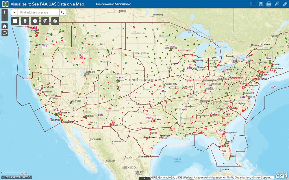
The most recent proposed Notice to Airmen (NOTAM) lists federal correctional facilities in almost half of the states in the U.S., several medical centers, U.S. Army facilities, ammunition plants and Pearl Harbor in Hawaii. It’s hard to understand why there aren’t already permanent UAV prohibitions over all such sensitive facilities across the whole U.S. I tried to check status, but the FAA UAS Data Display System didn’t list this proposed NOTAM which apparently goes into force on Feb. 26.
Think it’s probably a question of preventing bad guys from planning or doing harm rather than being shy to be caught on video — but, for sure, these places should be as secure as possible.
The FAA UAS data map shows all drone-restricted areas, once updated. (Screenshot: FAA)
Security at the Super Bowl
Well the game wasn’t the most exciting, with New England doing all that was needed to win in the fourth quarter, but the security for the event in Atlanta was humongous.
The area around the stadium was cleared of threats even before the game, attendees were screened for prohibited items and the airspace within 30 miles was restricted for general aviation and drone access. There were even Defense Department F-16 airspace patrols, and the Customs and Border Patrol had a Black Hawk helicopter available to intercept any aircraft penetrating the exclusion zone.
Nevertheless, the FAA still approved the operation of two tethered drones. One was flown close to the stadium by security personnel to provide live images of crowd movements in and around the stadium. The second system was operated at 45 meters above the rooftop of the CNN building facing the Mercedes Benz Stadium. CNN used it to provide aerial imagery of the scene before and after the game.
Elistair base station and DJI M200 at Super Bowl. (Photo: Elistair)
The tethered drone setup included two DJI M200 drones and two Elistair Ligh-T base stations, with monitoring, control and power provided to each drone by lightweight tethers. The security system was continuously operationed for 10 hours of captive flight during the Super Bowl, and for 14 hours total over two days — all while tethered to the Ligh-T control station. Security officials expressed their interest in using this solution more often because of the ability to follow a subject continuously without having to switch from one fixed camera to another, which risks losing the subject.
To sum up, new pending FAA regulations that support operations over people may have a few flaws. Other new FAA rules are aimed at protecting DOD and DOJ facilities from drone overflights, and tethered drones were used at the Super Bowl for crowd security and by CNN for color coverage.
New applications, new opportunities and preventive controls to maintain security at sensitive facilities — all moving in the right direction.
The Federal Aviation Administration (FAA) has issued additional drone flight restrictions over U.S. federal prisons, military bases and Pearl Harbor, effective Feb. 26.
At the request of its federal security partners, the FAA is using its existing authority under Title 14 of the Code of Federal Regulations (14 CFR) § 99.7 — “Special Security Instructions” — to address concerns about drone operations over national security sensitive facilities by establishing temporary unmanned aircraft system (UAS) specific flight restrictions.
Information on the FAA Notice to Airmen (NOTAM), which defines these restrictions, and all of the currently covered locations, can be found at the FAA’s UAS Data Display System, which provides an interactive map, downloadable geospatial data, and other important details.
A link to the restrictions is also included in the FAA’s B4UFLY mobile app.
Additional, broader information regarding flying drones in the National Airspace System, including frequently asked questions, is available on the FAA’s UAS website.
In cooperation with Department of Justice (DOJ) and Department of Defense (DOD), the FAA is establishing additional restrictions on drone flights up to 400 feet within the lateral boundaries of the following federal facilities:
Federal Correctional Institution Allenwood Medium in Allenwood, PA
Federal Correctional Institution Beaumont Medium in Beaumont, TX
Federal Correctional Institution Butner Medium I in Butner, NC
Federal Correctional Institution Butner Medium II in Butner, NC
Federal Correctional Institution Coleman Medium near Sumterville, FL
Federal Correctional Institution Florence in Florence, CO
Federal Correctional Institution Forrest City Medium in Forrest City, AR
Federal Correctional Institution Hazelton near Bruceton Mills, WV
Federal Correctional Institution Lompoc in Lompoc, CA
Federal Correctional Institution Oakdale I in Oakdale, LA
Federal Correctional Institution Oakdale II in Oakdale, LA
Federal Correctional Institution Petersburg near Hopewell, VA
Federal Correctional Institution Pollock in Pollock, LA
Federal Correctional Institution Terre Haute in Terre Haute, IN
Federal Correctional Institution Tucson in Tucson, AZ
Federal Correctional Institution Victorville Medium I in Victorville, CA
Federal Correctional Institution Victorville Medium II in Victorville, CA
Federal Correctional Institution Yazoo City Medium in Yazoo City, MS
Federal Detention Center Honolulu in Honolulu, HI
Federal Detention Center Houston in Houston, TX
Federal Detention Center Miami in Miami, FL
Federal Detention Center Philadelphia in Philadelphia, PA
Federal Detention Center SeaTac near Seattle, WA
Federal Medical Center Carswell near Fort Worth, TX
Federal Medical Center Fort Worth in Fort Worth, TX
Federal Medical Center Rochester in Rochester, MN
Metropolitan Correctional Center Chicago in Chicago, IL
Metropolitan Correctional Center New York in New York City, NY
Metropolitan Correctional Center San Diego in San Diego, CA
Medical Center for Federal Prisoners Springfield in Springfield, MO
Metropolitan Detention Center Brooklyn in Brooklyn, NY
Metropolitan Detention Center Guaynabo in Guaynabo, PR
Metropolitan Detention Center Los Angeles in Los Angeles, CA
Fort Detrick in Frederick, MD
Fort Gordon near Augusta, GA
Fort Lee near Richmond, VA
Holston Army Ammunition Plant near Kingsport, TN
McAlester Army Ammunition Plant in McAlester, OK
Radford Army Ammunition Plant in Radford, VA
Joint Base McGuire near Trenton, NJ
Pearl Harbor Naval Defense Sea Area in Honolulu, HI
These changes, which have been highlighted by FAA NOTAM FDC [9/2586], are pending until they become effective on Feb. 26. Note that there are only a few exceptions that permit drone flights within these restrictions, and they must be coordinated with the individual facility or the FAA.
Operators who violate the flight restrictions may be subject to enforcement action, including potential civil penalties and criminal charges.
The FAA is continuing to consider additional requests by eligible federal security agencies for UAS-specific flight restrictions using the agency’s § 99.7 authority as they are received. Additional changes to these restrictions will be announced by the FAA as appropriate.
This report covers a number of UAV topics, including the news of another U.S. Federal Aviation Administration (FAA) program to advance drone integration in the U.S. National Airspace System (NAS); an initial effort towards Type Certification for a larger UAV/UAS; cautious steps to protect U.S. Navy and Coast Guard ships from unwanted drone overflight; and what would appear to be a surge in the number of acquisitions across the industry.
FAA Integration Pilot Program
There are signs of growing momentum to get UAVs flying in the U.S. NAS. The FAA Integration Pilot Program (IPP) website indicates that this latest initiative is spread across a number of different applications, locations and supporting organizations. The FAA cites the following objectives for IPP:
Connecting local and national UAS integration interests
Improving local, state and tribal communications
Addressing security and privacy risks
Speeding up special authorizations.
So it’s perhaps more about getting organizations at the local level into the picture, and fostering cooperation with national interests. But, at the same time, pilot projects will feed knowledge into the hopper of how to get UAVs into the U.S. NAS.
Operational concepts to be investigated include night operations, flights over people, flights beyond visual line of sight, package delivery trails, testing detect-and-avoid technologies and verifying the reliability and security of UAS data links.
Certification Program underway for Insitu ScanEagle3
Along the same lines, Insitu is working with FAA staff towards certification of the commercial ScanEagle3 drone system to enable flights in U.S. controlled airspace. A recent three-day Type Certification Board meeting held between FAA and Insitu included launch-to-capture flight tests, plus review of applicable standards, flight training and technical publications and manuals to determine Insitu’s basis for the proposed UAS Type Certification of the ScanEagle3 in 2019.
Once an aircraft or UAS gains Type Certification, it should be possible to fly that model on a regular basis, without the need for special FAA authorization of individual operations, as is currently the requirement for drones — other than for small UAS (sUAS), which already have FAA approved operational regulations. This effort could also clear the way for certification of larger drones to regularly operate in the NAS. Filing a flight plan with local FAA controllers prior to each flight would then typically be required, as is standard for all manned aircraft.
FAA review teams examine Insitu’s ScanEagle3 at a type certification board meeting in Bingen, Washington (Photo: Insitu)
At the recent review meeting with FAA team members from various certification groups, Insitu discussed its internal culture of safety, which is in line with the FAA’s extremely strict safety standards. The design and technology of ScanEagle3 was demonstrated, and the maturity of Insitu as an aircraft manufacturer was emphasized.
The FAA teams participated in an overview of Insitu’s Project Plan for Certification, examining Insitu’s detect-and-avoid (DAA) capability planning, safety management system and model-based engineering processes.
Insitu is hopeful that Type Certification will enable ScanEagle3 to be applied quickly to all types of operation, which could include data collection, analysis and delivery; aerial infrastructure survey; disaster recovery; and wildfire suppression – without the delay currently associated with seeking permits and overcoming temporary flight restrictions.
FAA restricts drone operations near sensitive U.S. facilities
Meanwhile, the FAA flexed its legal muscles to restrict drone flights near U.S. Navy (USN), U.S. Coast Guard (USCG) and Department of Energy (DoE) facilities and assets. Growing concerns with potential malicious drone flights over sensitive, high-priority facilities and ships apparently prompted the FAA to issue two NOTAMs (Notice to Airmen). The first notification describes the locations and the assets – in this case, ships operating from two bases — and includes the form of restrictions that are being applied.
Drone flights have been restricted around USN and USCG vessels operating near Naval Base Kitsap in Washington state and Naval Submarine Base Kings Bay in Georgia. Drones are not allowed to get closer than 3,000 feet laterally and 1,000 feet vertically from vessels. And the NOTAMs carry the dire warning that these ships have the authorization and ability to take whatever action they feel necessary to protect themselves from such threats.
In other words, if the nut-case flying an unwelcome drone penetrates the restricted area around a Navy or Coast Guard ship, the target ship might well take out the unwanted drone. And the FAA may also pursue civil penalties and/or criminal charges against the operator for disobeying the restrictive notice.
The second NOTAM warns drone flyers to remain clear of all national Department of Defense (DoD) and DoE facilities and mobile assets, as well as USCG vessels. With UAVs carrying explosive devices becoming more common in areas of conflict or political unrest (in Venezuela, for instance), it’s not surprising that U.S. DoD is concerned this could soon start to happen closer to home.
Industry consolidation continues
Finally, following a letter of intent from Textron Systems to buy Howe & Howe Technologies a land mobile robotics defense outfit, drone industry consolidation also seems to be gaining momentum.
Howe & Howe’s land vehicles are built and proven for extreme environmental conditions, and U.S. government customers have selected Howe & Howe’s small, highly mobile Ripsaw Super Tank for its speed, mobility and off-road performance, while the RS2-H1 SMET was down-selected to compete to be the U.S. Army’s first platoon load-carrying robot, after completing a 60-mile test through swamp and jungle terrains.
Textron Systems continues to position itself as a global leader in autonomy applications in air, land and sea.
In addition, Delair has just announced an agreement to acquire the key assets of Airware — a developer of software analytics tools for data collected by drones. The acquisition quickens Delair’s growth and increases options for the commercial UAV market. Delair provides end-to-end solutions, including fixed-wing drones, cloud-based data processing and analysis, local customer support and custom consulting services.
Delair UX11 mapping drone (Photo: Delair)
The acquisition is through an asset purchase of Airware’s technology, including proven software, related personnel in Paris, existing customer relations and established distribution channels. Airware’s data management and data analysis tools will be highly complementary with Delair’s existing solutions and will also expand Delair’s U.S. market presence, providing access to additional key industrial markets.
Airware, based in California, has provided a cloud-based software solution to large companies in the construction, mining and insurance industries. Its software solution was developed with support from Caterpillar and has been distributed by Caterpillar dealers to more than 50 countries to improve the productivity and safety in mines, quarries and construction sites.
Delair, with more than 180 employees worldwide, has customers in a number of industries including mining, construction, energy, utilities, oil and gas, transportation and security.
PrecisionHawk has also announced the purchase of Uplift Data Partners, which provides turnkey inspection services for construction, building information management (BIM) and real-estate. This is PrecisionHawk’s fifth acquisition during 2018 — earlier acquisitions have included Droners.io, Airvid, HAZON and InspecTools. These acquisitions have created dynamic synergy, and provided enhanced airborne intelligence with strengthened data value for PrecisionHawk.
Uplift’s commercially trained drone pilots will join PrecisionHawk’s network of more than 15,000 drone pilots, one of the largest networks of its kind. Suzanne El-Moursi, CEO of Uplift, will join PrecisionHawk’s executive team and will manage the company’s construction business.
The intent is for customers to receive best-in-class aerial data and analytics for complex construction and facility inspection projects, through combined PrecisionHawk’s advanced products and services, and Uplift’s industry experience and training standards.
PrecisionHawk and Uplink will combine products for construction projects. (Photo: PrecisionHawk)
Uplift Data Partners has been an integrated subsidiary of Clayco, an architecture, engineering, design-build and construction firm, with more than $2 billion in annual revenue. Following the spin-off, Clayco will still source its construction projects exclusively to PrecisionHawk, and will support PrecisionHawk’s board of advisors.
The construction industry has rapidly adopted commercial drone technology — transforming construction processes by decreasing the need for protracted visual inspections, shortening planning time, improving worker safety and quickly identifying problems.
And finally — Microdrones, a provider of professional UAV solutions, has announced that it has acquired geomatics service provider Navmatica Middle East (ME) with an office and team in Dubai, UAE. Navmatica ME supplies services and custom software development for geodetic positioning, airborne mapping, mobile mapping and indoor mapping.
Microdrones md4-3000 drone. (Photo: Microdrones)
The acquisition establishes a foothold in the Middle East market for commercial drones, and adds an experienced team of geomatics engineering specialists, software developers and systems engineers who have a proven track record of providing customers with high-quality geomatics services and technology.
Summary
We have FAA efforts to move further forward with UAV integration with its IPP program, first steps down the lengthy and somewhat arduous path towards the certification of larger UAVs to enable less restrictive flight in the U.S. NAS, notifications to operators to improve protection of Navy and Coast Guard ships from unwanted overflight and potential drone attack, and plenty of signs of drone service and manufacturer business consolidation — lots of what we may think of as positive indications of greater maturity and progress for the UAV industry.
Photo: iStock.com/NiseriN via the Federal Aviation Administration
In cooperation with the U.S. Department of Defense (DoD), the Federal Aviation Administration (FAA) is establishing restrictions on drone flights up to 400 feet within the lateral boundaries of National Geospatial-Intelligence Agency (NGA) facilities.
The temporary flight restrictions — specific to unmanned aircraft systems (UAS) — apply to three NGA facilities in or near St. Louis:
National Geospatial-Intelligence Agency (NGA) West
NGA Next West
NGA Arnold
In June, the FAA responded to federal agency requests and restricted drone operations over penitentiaries and Coast Guard bases.
The Federal Aviation Administration (FAA) is using its existing authority under Title 14 of the Code of Federal Regulations § 99.7 — “Special Security Instructions” — to address concerns about drone operations over national security-sensitive facilities.
The changes, which are highlighted by FAA NOTAM FDC 8/7350, are pending until they become effective on Aug. 30.
Only a few exceptions permit drone flights within these restrictions, and they must be coordinated with the individual facility and/or the FAA.
Operators who violate the flight restrictions may be subject to enforcement action, including potential civil penalties and criminal charges.
To ensure the public is aware of restricted locations, the FAA website also provides an interactive map, downloadable geospatial data and other important details. The restrictions also are depicted in the FAA’s B4UFLY mobile app. Broader information regarding flying drones in the National Airspace System, including frequently asked questions, is available on the FAA’s UAS website.
The FAA continues to consider additional requests by eligible federal security agencies for UAS-specific flight restrictions using the agency’s § 99.7 authority as they are received. Additional changes to these restrictions will be announced by the FAA as appropriate.
The Federal Aviation Administration (FAA) has established temporary unmanned aircraft system (UAS) flight restrictions over federal penitentiaries and U.S. Coast Guard bases.
The restrictions, which take place June 20, are for drone flights up to 400 feet within the lateral boundaries of the facilities.
The restrictions came at the request of federal security partners the Department of Justice (DOJ) and Department of Homeland Security (DHS).
The FAA is using its existing authority under Title 14 of the Code of Federal Regulations (14 CFR) § 99.7 — “Special Security Instructions” — to address concerns about drone operations over these facilities,” the agency stated.
Information on the FAA Notice to Airmen (NOTAM), which defines these restrictions, and the covered locations, can be found on the FAA’s UAS website. Broader information regarding flying drones in the National Airspace System, including frequently asked questions, is also on the FAA website.
An interactive map, downloadable geospatial data and other important details can be found here.
A link to the restrictions is also included in the FAA’s B4UFLY mobile app.
This is the first time the FAA has placed specific flight restrictions for unmanned aircraft over Federal Bureau of Prisons and Coast Guard facilities. The FAA has placed similar flight restrictions over military installations that remain in place, as well as over 10 Department of Interior facilities and seven Department of Energy facilities.
Operators who violate the flight restrictions may be subject to enforcement action, including potential civil penalties and criminal charges.
There are a few exceptions that permit drone flights, which must be coordinated with the individual facility or the FAA.
The FAA is considering additional requests by eligible federal security agencies for UAS-specific flight restrictions using the agency’s §99.7 authority as they are received. Additional changes to these restrictions will be announced by the FAA as appropriate.
The following facilities will have the new restrictions:
United States Penitentiaries (USP)
USP Tucson near Tucson, AZ
USP Atwater near Atwater, CA
USP Victorville near Victorville, CA
USP Florence High near Florence, CO
USP Florence ADMAX near Florence, CO
USP Coleman I near Sumterville, FL
USP Coleman II near Sumterville, FL
USP Marion near Marion, IL
USP Terre Haute near Terre Haute, IN
USP Big Sandy near Inez, KY
USP McCreary near Pine Knot, KY
USP Pollock near Pollock, LA
USP Yazoo City near Yazoo City, MS
USP Allenwood near Allenwood, PA
USP Canaan near Waymart, PA
USP Lewisburg near Lewisburg, PA
USP Beaumont near Beaumont, TX
USP Lee near Pennington Gap, VA
USP Hazelton near Bruceton Mills, WV
United States Coast Guard (USCG) Bases
USCG Baltimore Yard, MD
USCG Base Boston, MA
USCG Base Alameda, CA
USCG Base Los Angeles/Long Beach (LALB), CA
USCG Base Elizabeth City, NC
USCG Base Kodiak, AK
USCG Base Miami, FL
USCG Base Portsmouth, VA
USCG Base Seattle, WA
USCG Operations System Center (OSC) near Martinsburg, WV
“We know our diverse new partners will help us address a broad range of complex drone integration challenges,” said FAA Acting Administrator Dan Elwell. “The fields that could see immediate opportunities from the program include commerce, photography, emergency management, public safety, precision agriculture and infrastructure inspections.”
The 10 programs are:
Choctaw Nation of Oklahoma, Durant, Oklahoma
City of San Diego, California
Innovation and Entrepreneurship Investment Authority, Herndon, Virginia
Kansas Department of Transportation
Lee County Mosquito Control District
Memphis-Shelby County Airport Authority
North Carolina Department of Transportation
North Dakota Department of Transportation
City of Reno, Nevada
University of Alaska-Fairbanks
Over the next two and a half years, the selectees will collect drone data involving night operations, flights over people and beyond the pilot’s line of sight, package delivery, detect-and-avoid technologies and the reliability and security of data links between pilot and aircraft.
The data collected from these operations will help the FAA:
craft new enabling rules that allow more complex low-altitude operations,
identify ways to balance local and national interests related to UAS integration,
improve communications with local, state and tribal jurisdictions,
address security and privacy risks, and
accelerate the approval of operations that currently require special authorizations.
First announced in October 2017, the White House initiative partners the FAA with local, state and tribal governments, which then partner with private industry to safely explore the further integration of drone operations.
The program will help tackle the most significant challenges to integrating drones into the national airspace and will reduce risks to public safety and security.
Brian Wynne, president and CEO of the Association for Unmanned Vehicle Systems International (AUVSI), issued the following statement on the announcement of the participants selected for the FAA’s Unmanned Aircraft Systems (UAS) Integration Pilot Program:
“The participants selected for the FAA’s UAS Integration Pilot Program represent a commitment by governments at all levels to safely and efficiently integrate UAS into the national airspace. As more and more businesses and public institutions embrace UAS, it is more important than ever to have a process in which states, municipalities and tribal governments can provide input on federal policy without infringing on the U.S. government’s jurisdiction over the airspace.
“The data the participants will collect on UAS operations will help shape a national UAS policy framework, including for a UAS traffic management system and expanded UAS operations such as flying over people or beyond line of sight,” Wynne said. “We look forward to seeing the results of their work and the contributions these groups will make to keeping our skies safe.”
According to AUVSI, the potential economic benefit of drones in the nation’s air space, in less than a decade, is estimated at $82 billion and could create 100,000 jobs.
Drone maker DJI issued a statement saying it looks forward to the advances in drone regulatory procedures that will be enabled by the innovative proposals offered by the 10 state, local and tribal governments.
“Regulators and governments want to develop safe systems that encourage the beneficial uses of drones while addressing concerns about them, and today’s announcement is a major step forward in this effort,” said Brendan Schulman, DJI vice president of Policy & Legal Affairs. “By connecting state, local and tribal governments with industry partners and federal support, the Integration Pilot Program makes it easier to find ways for American businesses, governments and individuals to put drones to good uses all across the country.”
With great sadness we must report that Per Enge passed away on April 22, at home and surrounded by family. Per was a genial friend and colleague to many, and a pillar of the PNT community. He is greatly missed by all.
At the culmination of his long, fruitful career he served as the Vance and Arlene Coffman Professor of Engineering at Stanford University, where he also directed the Stanford Center for Position Navigation and Time.
For many years he conducted research funded by the Federal Aviation Administration, directed at safe and secure air navigation and leading to development of the Wide Area Augentation System (WAAS) and Local Area Augmentation Systems (LAAS). WAAS became fully operational for aviation in the United States in 2003 and is currently carried by more than 110,000 aircraft; similar systems have been deployed in Europe, Japan and India.
Per Enge at National Cheng Kung University (courtesy Shau Shiu Jan).
He received the Kepler Award from the Institute of Navigation in 2000 and was inducted into the GPS Hall of Fame by the U.S. Air Force in 2012. He served as a member of the Space-Based Position Navigation and Time Federal Advisory Committee since 2007. In 2013 he received the GNSS Leadership Award for Signals from this magazine, for signal design including national differential GPS, satellite-based augmentation systems, and alternative positioning, navigation and timing sources. He co-wrote Global Positioning System: Signals, Measurements, and Performance.
Always an educator, Per served as instructor, mentor and gentle encourager of many, many Ph.D. and other graduate-level students at Stanford who have gone on to distinguished careers of their own. In a lifetime marked by great achievements, this is perhaps his greatest and ultimately will be the most far-reaching.
Born in Norway and brought to the U.S. at age 2, he received a B.S.E.E. from the University of Massachusetts and M.S.E.E. and Ph.D. degrees from the University of Illinois.
Speaking at GPS World dinner, accepting Signals Leadership 2013 award. (Photo: GPS World file)
In remarks on accepting the GNSS Leadership Award for Signals, Per cited Faflick’s theorem, “that you will never ever work on any projects that are both interesting and important.” After calling out both GNSS and WAAS as exceptions to the theorem, he identified a third outlier: spoofing.
“Today’s e-security is based on three security factors: what we know (passwords), what we carry (key fob), and what we are (fingerprints, iris scan). And it is not enough. To meet this challenge, we need to rejuvenate the original security factor: location. In the past, transactions were secured by our presence. In the world of e-commerce, this factor has disappeared, and we must use GNSS to approximate this ancient and effective security factor.
“All of this will require the best effort of this precious community of ours.”
Further biographical details are available in an article published by the Stanford News. Among the tributes included there is this one by Brad Parkinson, who recruited Enge to Stanford in the early 1990s. “Anyone who works in GPS is aware of Per and his influence. He was just an intellectually talented person who could understand many scientific nuances and integrate them in ways others could not.”
Teaching the massive online open course.
The article also reminds us that he co-originated and co-taught, with Frank van Diggelen, a massive open online course to share GPS knowledge with a worldwide audience, far beyond Stanford’s walls. Titled “GPS: An Introduction to Satellite Navigation, with an interactive Worldwide Laboratory using Smartphones,” it enrolled 31,000 people from 192 countries. It is available here.
Per’s Stanford colleagues Sherman Lo, Todd Walter and Sam Pullen assisted GPS World with this article and provided these photos from personal archives. The Stanford group is working on setting up a scholarship in Per’s name. More information on it and how to support it will be on the SCPNT website once it becomes available.
Frank van Diggelen has sent further photos, below.
At the Stanford GPS Lab with colleagues from Stanford and DLR (German aerospace agency).
Dinner discussions with US-EU bilateral group.With Alan Chen, Sherman Lo and an early spectrum image of GIOVE-A (or Galileo).Visiting Neuschwanstein Castle in Bavaria after 2005 European Navigation Conference.At the Stanford Center Position, Navigation and Time, which he co-founded in 2005.Team China Consumers at GPS World dinner 2010. The winning team in the Grand Game of GNSS.Fierce “opponents” (examiners) for Ph.D. defense of Ignacio Fernández Hernández of EC/Galileo. Aalborg University, Denmark.Prepared to come aboard in Kobenhavn.The co-authors of Global Positioning System: Signals, Measurements, and Performance (with Pratap Misra).
A road warrior for GNSS.
Faculty of the GNSS Summer School at Svalbard, Norway (Arctic Ocean, 78.7° N).
The Federal Aviation Administration (FAA) is expanding tests of an automated system that will ultimately provide near real-time processing of airspace authorization requests for unmanned aircraft (UAS) operators nationwide.
FAA Acting Administrator Dan Elwell announced the expansion at the third annual UAS Symposium, which kicked off on March 6 in Baltimore.
Under the FAA’s Part 107 small drone rule, operators must secure approval from the agency to operate in any airspace controlled by an air traffic facility. To facilitate those approvals, the agency deployed the prototype Low Altitude Authorization and Notification Capability (LAANC) at several air traffic facilities in November 2017 to evaluate the feasibility of a fully automated solution enabled by data sharing.
Based on the prototype’s success, the agency will now conduct a nationwide beta test beginning April 30 that will deploy LAANC incrementally at nearly 300 air traffic facilities covering approximately 500 airports. The final deployment will begin on Sept. 13.
Drone operators using LAANC can receive near real-time airspace authorizations. This dramatically decreases the wait experienced using the manual authorization process and allows operators to quickly plan their flights. Air traffic controllers also can see where planned drone operations will take place.
Beginning April 16, the FAA also will consider agreements with additional entities to provide LAANC services. Currently, there are four providers — AirMap, Project Wing, Rockwell Collins and Skyward. Applications must be made by May 16.
Interested parties can find information on the application process here. This is not a standard government acquisition; there is no Screening Information Request (SIR) or Request for Proposal (RFP) related to this effort.
LAANC uses airspace data provided through UAS facility maps. The maps show the maximum altitude around airports where the FAA may authorize operations under Part 107. LAANC gives drone operators the ability to interact with the maps and provide automatic notification and authorization requests to the FAA. It is an important step in developing the Unmanned Aircraft Systems Traffic Management System (UTM).