The Federal Aviation Administration’s (FAA) Small Unmanned Aircraft System (UAS) registry is now live and ready for owners of hobby UAS to use at www.faa.gov/uas/registration. Registration is free for the first 30 days with a rebate, then $5 after that.
The online registration system does not yet support registration of small UAS used for any purpose other than hobby or recreation — for example, using an unmanned aircraft in connection with a business. The FAA is developing enhancements that will allow such online registrations by spring of 2016.
During the registration process, each owner must provide his or her name, home address and e-mail address. When registration is complete, the web application will generate a Certificate of Aircraft Registration/Proof of Ownership including a unique identification number for the UAS owner, which must be marked on the aircraft.
Owners using the model aircraft for hobby or recreation will only have to register once and may use the same identification number for all of their model UAS. The registration is valid for three years.
All aircraft weighing more than 0.55 pounds (250 grams) and less than 55 pounds (approx. 25 kilograms), including payloads such as on-board cameras, must be registered.
Under this rule, owners who previously operated an unmanned aircraft exclusively as a model aircraft prior to Dec. 21, 2015, must register no later than Feb. 19, 2016. Owners of any other UAS purchased for use as a model aircraft after Dec. 21 must register before the first flight outdoors. Owners can use either the paper-based process or the new streamlined, web-based system. Owners using the new streamlined web-based system must be at least 13 years old to register.
The FAA also reminds unmanned aircraft owners there’s no need to work with a “drone registration” company to help file an application for a registration number. The registration site is designed to be simple and easy to use for every hobbyist.
The FAA has partnered with several industry associations to educate the public about using unmanned aircraft safely and responsibly. Flight rules include:
Fly below 400 feet altitude.
Keep your unmanned aircraft in sight at all times.
Never fly near manned aircraft, especially near airports.
Never fly over groups of people, stadiums or sporting events.
The Federal Aviation Administration announced on Dec. 14 an official rule and registration process for hobbyists who own small unmanned aircraft weighing more than 0.55 pounds and less than 55 pounds, including payloads such as on-board cameras.
The online registration system does not yet support registration of small UAS used for any purpose other than hobby or recreation — for example, using an unmanned aircraft in connection with a business. The FAA is developing enhancements that will allow such online registrations by spring of 2016.
The registration procedure is a statutory requirement that applies to all hobby aircraft. Under this rule, any owner of a small UAS who has previously operated an unmanned aircraft exclusively as a model aircraft prior to Dec. 21, 2015, must register no later than Feb. 19, 2016. Owners of any other UAS purchased for use as a model aircraft after Dec. 21, 2015, must register before the first flight outdoors.
The Registration Task Force delivered recommendations to FAA Administrator Michael Huerta and Transportation Secretary Anthony Foxx on Nov. 21. The rule incorporates many of the task force recommendations, the FAA says.
“Make no mistake: unmanned aircraft enthusiast are aviators, and with that title comes a great deal of responsibility,” Foxx said in the announcement. “Registration gives us an opportunity to work with these users to operate their unmanned aircraft safely. I’m excited to welcome these new aviators into the culture of safety and responsibility that defines American innovation.”
Owners may register through a web-based system or paper-based process. There is a $5 registration fee, but the FAA is offering a full rebate for those who register before Jan. 20, 2016.
Under the rule, each aircraft must be marked with a unique number, although not necessarily the serial number. The goal is to help authorities track down an owner if a drone collides with another aircraft, flies too high or encroaches on an airport.
Registrants will need to provide their name, home address and email address. Upon completion of the registration process, the web application will generate a Certificate of Aircraft Registration/Proof of Ownership that will include a unique identification number for the UAS owner, which must be marked on the aircraft.
Owners using the model aircraft for hobby or recreation will only have to register once and may use the same identification number for all of their model UAS. The registration is valid for three years.
“We expect hundreds of thousands of model unmanned aircraft will be purchased this holiday season,” Huerta said. “Registration gives us the opportunity to educate these new airspace users before they fly so they know the airspace rules and understand they are accountable to the public for flying responsibly.”
New Task Force to Develop Recommendations by Nov. 20
WASHINGTON — U.S. Transportation Secretary Anthony Foxx and FAA Administrator Michael Huerta today announced the creation of a task force to develop recommendations for a registration process for Unmanned Aircraft Systems (UAS).
The task force will be composed of 25 to 30 diverse representatives from the UAS and manned aviation industries, the federal government and other stakeholders. The group will advise the department on which aircraft should be exempt from registration due to a low safety risk, including toys and certain other small UAS. The task force also will explore options for a streamlined system that would make registration less burdensome for commercial UAS operators.
The task force may make additional safety recommendations as it deems appropriate. Secretary Foxx directed the group to deliver its report by Nov. 20.
“Registering unmanned aircraft will help build a culture of accountability and responsibility, especially with new users who have no experience operating in the U.S. aviation system,” Foxx said. “It will help protect public safety in the air and on the ground.”
Every day, the FAA receives reports of potentially unsafe UAS operations. Pilot sightings of UAS doubled between 2014 and 2015. The reports ranged from incidents at major sporting events and flights near manned aircraft, to interference with wildfire operations.
“These reports signal a troubling trend,” Huerta said. “Registration will help make sure that operators know the rules and remain accountable to the public for flying their unmanned aircraft responsibly. When they don’t fly safely, they’ll know there will be consequences.”
While the task force does its work, the FAA will continue its aggressive education and outreach efforts, including the Know Before You Fly campaign and No Drone Zone initiatives with the nation’s busiest airports. The agency also will continue to take strong enforcement action against egregious violators. At the same time, it will continue working with stakeholders to improve safety to ensure further integration and innovation in this promising segment of aviation.
Secretary Foxx was joined by representatives from the following stakeholder groups:
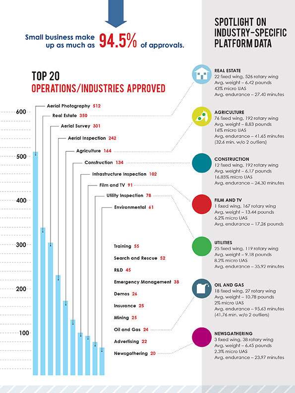
The Association for Unmanned Vehicle Systems International (AUVSI) today released a report that finds more than 25 types of business operations have been approved by the Federal Aviation Administration (FAA) to fly unmanned aircraft systems commercially in the National Airspace System (NAS). According to the report, aerial photography received the most exemptions followed by real estate and aerial surveying. The report also finds that exemptions have been approved in 49 states.
“These figures show that businesses across every industry sector have been waiting to use UAS for years and are excited to finally get this technology off the ground,” said Brian Wynne, president and CEO of AUVSI. “From inspecting bridges and power lines to filming movies and supporting emergency services, the applications of UAS are virtually limitless and enable researchers, public agencies and businesses to do things that were previously considered to be impossible.”
In May 2014, the FAA announced it would consider granting exemptions for certain low-risk commercial UAS applications under Section 333 of the FAA Modernization and Reform Act of 2012. Since then, the agency has received more than 2,700 requests and approved more than 1,400 petitions.
AUVSI analyzed the first 1,000 exemptions approved by the FAA. Specifically, the report finds:
The approved exemptions cover more than 25 types of business operations, with aerial photography receiving the most approvals with 512. Real estate followed with 350 exemptions and general aerial surveying with 301 exemptions.
Exemptions were approved for operators from 49 states. California received the most with 114, followed by Florida with 97 and Texas with 82.
California companies also manufactured the most platforms mentioned in the approvals, totaling 140. Florida followed with 19. In all, 22 states house manufacturers of platforms approved in the first 1,000 exemptions.
More than 90 percent of the first 1,000 exemptions were granted to small businesses.
Companies that received exemptions generate at least $500 billion to the U.S. economy annually and represent more than 600,000 jobs.
While the Section 333 process has continued to unlock the potential of UAS technology, AUVSI emphasized that regulating by exemption is no substitute for finalized rules.
“For the full potential of the UAS commercial market to be realized in the U.S., the FAA needs to finalize its small UAS rule as quickly as possible,” Wynne said. “Once this happens, we will have an established framework for UAS operations allowing anyone who follows the rule to fly. The positive effects of the regulation will be felt across the whole country.”
An economic impact study released by AUVSI in 2013 found the UAS industry will create more than 100,000 new jobs and more than $82 billion in economic impact within the first ten years following UAS integration.
The complete study, including state-by-state data, is available.
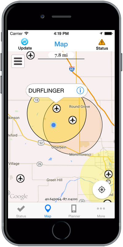
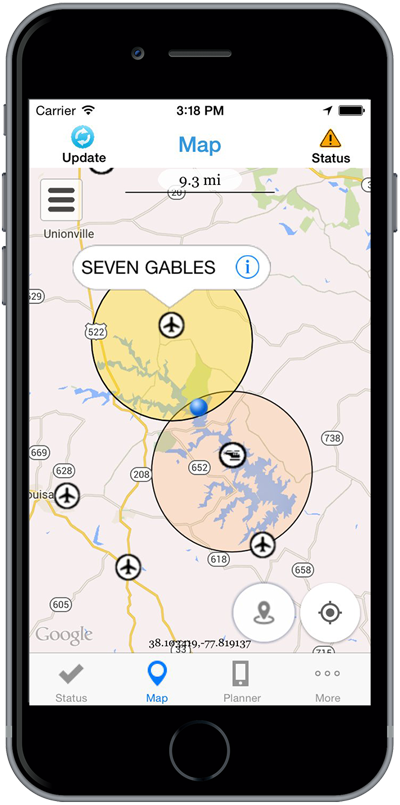
The Federal Aviation Administration (FAA) has released the beta version of a new smartphone application called B4UFLY for testing by up to 1,000 unmanned aircraft users.
The B4UFLY app, aimed primarily at model aircraft enthusiasts, is designed to give users information about restrictions or requirements in effect at their current or planned flight location. The FAA expects the beta test will yield valuable data on how well B4UFLY functions, as well as uncovering any software bugs.
FAA Administrator Michael Huerta first announced the initiative in May, asking for volunteers to test the app. The FAA has notified those who previously signed up and will be pushing the app to them directly in the coming days.
Many unmanned aircraft users today have little or no aviation experience, and some of them are flying where they could endanger manned aircraft. B4UFLY will give these flyers the tools and knowledge they need to operate safely.
Key features of the B4UFLY app include:
A clear “status” indicator that immediately informs operators about their current or planned location.
Information on the parameters that drive the status indicator.
A “Planner Mode” for future flights in different locations.
Informative, interactive maps with filtering options.
Links to other FAA UAS resources and regulatory information.
B4UFLY complements the Know Before You Fly educational campaign, which provides prospective UAS operators with information and guidance they need to fly safely and responsibly. The FAA is a partner in the effort with the Association for Unmanned Vehicle Systems International (AUVSI), Academy of Model Aeronautics (AMA), and the Small UAV Coalition.
Using the location services feature of a user’s smartphone, the app quickly determines restrictions or requirements in effect where they want to fly and gives the user a clear status icon. The status indicator function considers airspace, proximity to airports, temporary flight restrictions, current law and other FAA guidance and procedures.
Model aircraft operators who fly within five miles of an airport are required by law to notify the airport and the air traffic control tower — if there is one at the airport — prior to operating. The FAA is working on an electronic notification process to satisfy this requirement that will become part of a future version of B4UFLY. During the beta test, the FAA will collect user feedback and operational data and use it to develop this electronic notification process.
The beta test is expected to run for several months, after which the FAA plans to make B4UFLY available to the general public. The beta test will be for iOS devices only, but the FAA is working to ensure the full version will be compatible with Android devices as well.
The Federal Aviation Administration (FAA) wants to send out a clear message that operating drones around airplanes and helicopters is dangerous and illegal. Pilot reports of unmanned aircraft have increased dramatically over the past year, from a total of 238 sightings in all of 2014, to more than 650 by Aug. 9 of this year. Unauthorized operators may be subject to stiff fines and criminal charges, including possible jail time.
Pilots of a variety of different types of aircraft — including many large, commercial air carriers — reported spotting 16 unmanned aircraft in June 2014, and 36 the following month. This year, 138 pilots reported seeing drones at altitudes of up to 10,000 feet during the month of June, and another 137 in July.
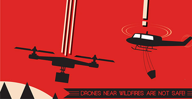
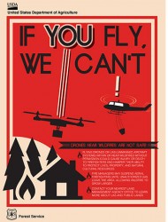
Meanwhile, firefighters battling wildfire blazes in the western part of the country have been forced to ground their operations on several occasions for safety reasons when they spotted one or more unmanned aircraft in their immediate vicinity.
The FAA says it will continue to work closely with industry partners through the “Know Before You Fly” campaign to educate unmanned aircraft users about where they can operate within the rules. The agency is also supporting the National Interagency Fire Center’s “If You Fly, We Can’t” efforts to help reduce interference with firefighting operations.
However, the FAA also is working closely with the law enforcement community to identify and investigate unauthorized unmanned aircraft operations. The FAA has levied civil penalties for a number of unauthorized flights in various parts of the country, and has dozens of open enforcement cases.
The FAA encourages the public to report unauthorized drone operations to local law enforcement and to help discourage this dangerous, illegal activity.
Amazon has announced a plan for its package-delivery drones, according to NBC News.
The proposal includes tiered flight zones that would limit small unmanned aircraft systems (sUAS) to slow speeds in airspace below 200 feet and allow them to fly faster for long-distance travel between 200 and 400 feet.
Commercial aircraft are governed by the Federal Aviation Administration’s (FAA’s) Air Traffic Control, and in Amazon’s vision, there would be a similar central command and control network that takes in data about the position of each drone and shares it with every other vehicle connected to the network. The command and control network would also have vehicle-to-vehicle communication, similar to networks proposed for autonomous automobiles.
Amazon’s plan would be to use the space below 500 feet — minus a 100-foot buffer — for small drones such as its Prime Air vehicles.
Access to the various layers of the airspace would be governed by how well a drone can communicate with its pilot, the command and control network and other drone, according to The Verge website. “Everyone can have access to the airspace,” said Gur Kimchi, who heads up Amazon’s Prime Air program. “It doesn’t matter if you’re a hobbyist or a corporation. If you’ve got the right equipment, you can fly.”
Someone operating a radio-controlled quadcopter with no Internet connection would be relegated to the area below 200 feet.
After a rigorous competition, the Federal Aviation Administration (FAA) has selected a Mississippi State University team as the FAA’s Center of Excellence for Unmanned Aircraft Systems (COE UAS). The COE will focus on research, education and training in areas critical to safe and successful integration of UAS into the nation’s airspace.
The team brings together 15 of the nation’s leading UAS and aviation universities that have a proven commitment to UAS research and development and the necessary resources to provide the matching contribution to the government’s investment.
“This world-class, public-private partnership will help us focus on the challenges and opportunities of this cutting-edge technology,” said U.S. Transportation Secretary Anthony Foxx. The Department of Transportation oversees the FAA. “We expect this team will help us to educate and train a cadre of unmanned aircraft professionals well into the future.”
The COE research areas are expected to evolve over time, but initially will include:
detect and avoid technology
low-altitude operations safety
control and communications
spectrum management
human factors
compatibility with air traffic control operations
training and certification of UAS pilots and other crew members, in addition to other areas.
“This team has the capabilities and resources to quickly get up and running to help the FAA address the demands of this challenging technology over the next decade,” said FAA Administrator Michael Huerta.
The FAA expects the COE will be able to begin research by September 2015 and be fully operational and engaged in a robust research agenda by January 2016.
Congress appropriated $5 million for the five-year agreement with the COE, which will be matched one-for-one by the team members.
In addition to Mississippi State University, the other team members include: Drexel University; Embry Riddle Aeronautical University; Kansas State University; Kansas University; Montana State University; New Mexico State University; North Carolina State University; Oregon State University; University of Alabama, Huntsville; University of Alaska, Fairbanks; University of North Dakota; and Wichita State University.
The FAA will determine the relationship between the new COE and the six UAS sites the FAA announced last year once the new team develops detailed research plans. The FAA expects COE flight testing to occur at one or more of the existing test sites.
Congress mandated that the FAA establish the COE under the Consolidated Appropriations Act of 2014. Like university think tank partnerships, the agency’s Centers of Excellence bring together the best minds in the nation to conduct research to educate, train and work with the FAA toward solutions for aviation-related challenges.
The U.S. Department of Transportation’s Federal Aviation Administration (FAA) today announced a partnership with industry to explore the next steps in unmanned aircraft operations beyond the type of operations the agency proposed in the draft small unmanned aircraft systems (UAS) rule it published in February.
“Government has some the best and brightest minds in aviation, but we can’t operate in a vacuum,” said U.S. Transportation Secretary Anthony Foxx. “This is a big job, and we’ll get to our goal of safe, widespread UAS integration more quickly by leveraging the resources and expertise of the industry.”
FAA Administrator Michael Huerta announced the initiative today at the Association for Unmanned Vehicle Systems International Unmanned Systems 2015 conference in Atlanta, Ga. See more coverage of the show from Geospatial Solutons.
The FAA is working with industry partners on three focus areas, including:
Visual line-of-sight operations in urban areas: CNN will look at how UAS might be safely used for newsgathering in populated areas.
Extended visual line-of-sight operations in rural areas: This concept involves UAS flights outside the pilot’s direct vision. UAS manufacturer PrecisionHawk will explore how this might allow greater UAS use for crop monitoring in precision agriculture operations.
Beyond visual line-of-sight in rural/isolated areas: BNSF Railroad will explore command-and-control challenges of using UAS to inspect rail system infrastructure.
“Even as we pursue our current rulemaking effort for small unmanned aircraft, we must continue to actively look for future ways to expand non-recreational UAS uses,” Huerta said. “This new initiative involving three leading U.S. companies will help us anticipate and address the needs of the evolving UAS industry.”
The three companies reached out to the FAA to work on research continuing to expand use of UAS in the nation’s airspace. CNN and the FAA already have been working together through a Cooperative Research and Development Agreement (CRDA). BNSF has a draft CRDA that is nearly complete and PrecisionHawk has been working with the FAA on a possible research partnership.
Further developing these operational concepts supports the FAA’s overall strategy to expand UAS access, which currently includes rulemaking, reviewing operational data from the six national UAS test sites, expanding commercial operations via the Section 333 exemption process, and issuing operational authorizations for type-certified UAS.
The FAA published a proposed rule for small UAS on February 23, 2015 and received nearly 4,500 public comments by the end of the comment period on April 24. The agency will work as quickly as possible, but must address all the comments submitted before finalizing the rule. The number and complexity of the comments will play a role in determining the timeline for a final rule.
Today’s second announcement of a new UAV-related initiative by the Federal Aviation Administration (FAA) was directed at private citizens: model airplane enthusiasts and hobbyists, also called modelers — not at industry or commercial use. See this story for information on the Pathfinder program for commercial drone use.
A soon-to-be released smartphone app will proved users with real-time information on flight regulations, and restrictions for the user’s actual location; alternately, for a location to which the user is planning to travel to for a model plane flight. Named B4UFly, the app is designed to answer for users, “Is it safe and is it legal to fly my model aircraft based on where I am right now?” The overall goal is to encourage responsible use of model aircraft.
The B4UFLY iOS app will be made available to 1,000 iPhone beta testers this summer. The first 700 emails received by [email protected]will make up the initial limited beta test group. Theemail is for model aircraft hobbyists only, who want to sign up for beta test. B4UFLY Version 1 for iOS will go out to the general public later this year. An Android app will come later.
“Someone who got their first UAV as a gift probably does not know [the rules governing flight and airspace operation],” said Jim Williams, the manager of the FAA’s Unmanned Aircraft Integration office. “It’s a knowledge gap that is very very important that we fill. Hobbyists and modelers need to know that there are very real consequences if you don’t have that knowledge. The recent Incident on the White House lawn provides a perfect case in point.”
The app was developed in cooperation with the MITRE Corporation. Key features of the B4UFLY app include:
A clear “status” indicator that immediately informs operators about their current or planned location.
Information on the parameters that drive the status indicator.
A “Planner Mode” for future flights in different locations.
Informative, interactive maps with filtering options.
Contact information for nearby airports.
Links to other FAA UAS resources and regulatory information.
The FAA’s Know Before You Fly campaign launched just prior to Christmas last year was a preliminary step in this effort.
Williams prefaced his remarks with, “These model planes and copters are ready to go, right out of the box. I know, I have one.” He then guided press through a brief look a clips and demo of the app’s key features. The app will provide real-time access to rules, requirements and restrictions based on location, and suggests specific actions to take if the user is:
within five miles of an airport
within a national park
within a restricted airspace (such as Washington, D.C.); and so.
The app will access the user’s location to automatically furnish this information. There is also a planning mode to see what data is available for a planned location to which you are preparing to go, although you are not there yet.
“Unmanned aircraft should always yeild the right of way to manned aircraft,” Williams stressed. “This is not the be-all and end-all of when and where you can fly. It does not alleviate the user’s responsibility to operate safely.”
In response to questions, FAA Administrator Michael Huerta clarified that the FAA currently issues flight restriction covering large public events, such as the Master’s golf tournament.
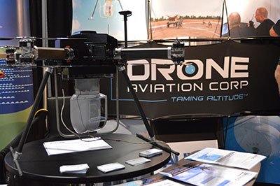
CNN will use Drone Aviation’s tethered drones to gather footage in in urban areas from never-seen-before angles and heights. The company’s WATT-200 was unveiled at the AUVSI this week.
Federal Aviation Administration (FAA) Administrator Michael Huerta announced two new initiatives related to unmanned aircraft systems (UAS) today at the Association for Unmanned Vehicle Systems International (AUVSI) Unmanned Systems 2015 conference in Atlanta, Ga.
Administrator Huerta told the large gathering of national journalists, “The unmanned aircraft industry is changing faster than any segment in the aircraft industry. A new project to harness that energy, the Pathfinder program, is partnering with three leading U.S. companies to expand unmanned aircraft operations in the United States.”
The FAA is working with industry partners on three focus areas:
CNN (Cable News Network) will research visual line of sight (LOS) operations for newsgathering in urban areas. CNN will continue working with Georgia Tech University to improve newsgathering for all organizations.
PrecisionHawk will investigate agricultural operations for rural areas, flying outside LOS.
BNSF Railway, second-largest freight railroad network in North America, will undertake inspection of rail infrastructure, also beyond visual LOS.
Huerta said that the partners, collectively, “are trying to push the envelope, what can we accommodate, accommodate safely, and what can we learn from that. We’ll test a little, learn a little, then test some more. How do we see a staged implementation? To integrate unmanned aircraft, but to do it safely, as directed by Congress. We’re trying to push the edges of what we can allow, working with partners who have specific uses and resources that they will apply to those.”
When asked for a timeframe to reach new UAV regulations, he replied, “I can’t comment a lot on the rule itself, but it’s fair to say that in the rulemaking comment process [which closed on April 24], we received more than 4,500 comments. It’s too early to say how those comments will shape what the final rulemaking will take. Assessment will be done in the coming months, perhaps by the end of the year, but that’s an aggressive timetable. This effort will go on as long as the partners want us to go on doing it. That’s not accomplished in six months, nor should it take a million years.”
As to LOS restrictions, and beyond LOS, he replied, “The framework of the previously published rule was focused on LOS, and on the use of visual observers in addition to the operator. Now we’re taking the next step, to explore beyond LOS uses. What are reasonable applications for that, and what mitigations for safety should be put in place for that? Everyone wants to get there. It’s important to figure out how we get there safely.”
What mitigations will be put in place for beyond LOS? A vice president of BSNF Railway said that the company is “working with FAA and several vendors around command and control infrastructure. This is yet to be fully defined. The railroad is a very safe an unforgiving environment. This doesn’t replace anything we’re doing today, it’s an addition.” He defined the operating environment as ” a 300 or 400-mile capability, to fly looking for broken rail, etc., beyond the visual, on-the-ground inspections that rail crews already do. ” He anticiated the use of “sense-and-avoid technology [for the UAVs], not using chase planes but perhaps using communications capabilities from cell towers and railway infrastructure along the right of way.”
The CEO of PrecisionHawk commented similarly, “We’re not changing much of our operational flow, just extending the baseline for it. We will implement a traffic-management technology, called Lattice, leveraging to ensure safety and reliability beyond the operator’s LOS.”
Gregory Agvent, CNN’s director of News Operations, said he looked forward to “some camera shots that were previously impossible for us, that now we’re going to be able to do.” Under the terms of the Certificate of Authorization (COA), Agvent said that “We’re capable of doing it [undertaking UAV missions] without asking for (FAA) permission” for specific flights.
The three industry participants concurred that they will work with their [UAV] partners in parallel with the rules to develop a certification process, so that the FAA can determine their vehicles are uniformly safe, the same way the y do with piloted aircraft currently. Both the railroad and PrecisionHawk have one currently operating flight platform each, and are looking at others, as theirs do not fit all applications.
“These are not exclusive [agreements],” emphasized Huerta, “limited to particular platforms or applications. This is a practical research effort to apply, learn, and integrate on the broadest scale.” When asked about possible further participants in the Pathfinder project, Huerta indicated the three companies represented on the briefing platform with him: “They came to us. You can interpret that as an invitation. We’re casting a very wide net. How do we et to a broader integration and implementation? We need multiple ways to gather information.”
Agvent urged, “It’s critical for manufacturers to come to the table, to get certified by make as opposed to individual models, to get free access to the sky.”
Huerta concluded, “We are learning together, as an industry and as a regulator. How can we collectively, as an industry, learn more in order to see a much more robust integration of unmanned aircraft into our aviation industry? We’re all interested in pushing the boundaries, and sharing the information broadly across the industry.”
The surprise preview of the pending announcement drew scores of curious and concerned industry representatives and exhibitors at the massive AUVSI show, who gathered anxiously outside the press briefing room, to which they were not admitted.
“The FAA is moving ahead with safe integration of UAS into the busiest, most complex airspace in the world,” according to an FAA statement issued prior to the briefing.”Even as the agency proceeds with rulemaking for small UAS, it continues to look at new ways to foster safe UAS operations by both hobbyists and businesses.”
With Exelis RangeVue, a high-performance GIS visualization engine provides real-time updates of critical operational elements.
Exelis has signed agreements with four Federal Aviation Administration (FAA)-designated unmanned aircraft systems (UAS) test sites for airspace situational awareness and research. The research will focus on using the Exelis Symphony RangeVue sense-and-avoid tool towards safe integration of unmanned aircraft into the national airspace system.
Under the terms of the agreements, the test sites will gain valuable real-time and historical situational awareness of the range airspace via Symphony RangeVue, while Exelis gains critical product feedback through operational usage. Participating test sites are:
Pan-Pacific UAS Test Range at University of Alaska, Fairbanks
Northern Plains UAS Test Site at University of North Dakota
Northeast UAS Airspace Integration Research Alliance at Griffiss International Airport, N.Y.
Mid-Atlantic Aviation Partnership at Virginia Polytechnic Institute
“The partnerships with these test sites are win-win arrangements,” said Ed Sayadian, vice president of Civil & Aerospace Systems for Exelis. “The test sites receive air traffic control quality surveillance data, increasing safety and enabling beyond-line-of-site operations, while Exelis gains critical product feedback, which will be used to shape and validate our service offerings.”
Symphony RangeVue enables UAS operators and test range personnel to have access to both real-time and historical aircraft surveillance information via a web-hosted platform, helping to manage mission operations across multiple locations.
Symphony RangeVue can be used as command center decision support and post-event analysis tool, or in the field as a sense-and-avoid addition to UAS ground control stations. Flexible geo-fencing tools alert operators when a UAS approaches airspace boundaries or other aircraft are in the vicinity.
Additionally, Exelis is pursuing research and development opportunities with the test sites exploring detect-and-avoid algorithms; non-cooperative target tracking; command and control systems; infrastructure inspection and monitoring; big data analysis for air traffic; and integration of non-FAA surveillance sources. Exelis will leverage capabilities across multiple test sites for a wide range of operational testing and collection of safety data.