Tag: First Fix

  • First fix: Trouble in orbit

    First fix: Trouble in orbit

    The solar storm in May that produced a beautiful aurora borealis as far south as Mallorca, Spain, also stopped GNSS-based precision agriculture for a couple of days. The same month, articles in major U.S. newspapers detailed aspects of a growing confrontation between the United States, Russia and China —vying for dominance in near-Earth space, now part of the military fighting domain — that could lead to far greater disruption. Nearly all satellites are highly vulnerable to cyberattacks, ground- or space-based lasers, high-powered microwaves, the debris field from a destroyed satellite and the radiation produced by a nuclear explosion in space. The last one would disable by far the greatest number of satellites because of its range and because commercial satellites, which constitute more than 90 percent of all satellites in orbit, are not hardened against such radiation.

    Matteo Luccio
    Luccio

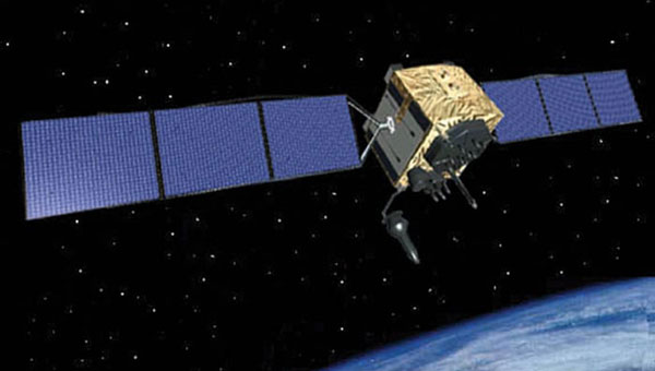
    A May 16 article in The Wall Street Journal titled “Russia Launched Research Spacecraft for Antisatellite Nuclear Weapon Two Years Ago, U.S. Officials Say,” reported that in February 2022, shortly before it invaded Ukraine, Russia launched Cosmos-2553, “designed to test components for a potential antisatellite weapon that would carry a nuclear device.” It linked the launch to a continuing Russian nuclear antisatellite program and said that, if deployed, the weapon “would give Moscow the ability to destroy hundreds of satellites in low-Earth orbit (LEO) with a nuclear blast.”

    “The Pentagon,” the article pointed out, “has become increasingly reliant on commercial satellites.” In LEO, it reported, there are almost 6,700 U.S. satellites, while China has 780 and Russia only 149. Therefore, the Russians would have a lot less to lose should they choose to explode a nuclear weapon in LEO.

    A May 17 article in The New York Times was titled “New Star Wars Plan: Pentagon Rushes to Counter Threats in Orbit.” The subhead read: “Citing rapid advances by China and Russia, the United States is building an extensive capacity to fight battles in space.” It said that, in a major shift in military operations, the Defense Department “is looking to acquire a new generation of ground- and space-based tools that will allow it to defend its satellite network from attack and, if necessary, to disrupt or disable enemy spacecraft in orbit.” Meanwhile, “both Russia and China have already tested or deployed systems such as ground-based high-energy lasers, antisatellite missiles or maneuverable satellites that could be used to disrupt [U.S.] space assets.”

    The decision to strengthen U.S. warfighting capacity in space, it said, is driven mostly by China’s expanding fleet of military tools in space, which threatens to prevent U.S. Navy operations in the Western Pacific. “The Pentagon is separately working to launch a new generation of military satellites that can maneuver, be refueled while in space or have robotic arms that could reach out and grab — and potentially disrupt — an enemy satellite.”

    These are all reasons to quickly develop and deploy a wide mix of complementary PNT solutions that would lessen reliance on GNSS satellites and, therefore, make them less of a target.

  • First Fix: GPS can stay first

    First Fix: GPS can stay first

    This month’s cover story focuses on jamming and spoofing in the military domain, but this is also a big challenge for users of civilian GNSS applications, such as airline pilots. Our July cover story will focus on complementary PNT — that is, non-GNSS sources of positioning, navigation and timing data that can complement GNSS and help make up for its inherent shortcomings, such as weak signals that are easily blocked by thick foliage and roofs, multipath and few satellites in view from natural and urban canyons.

    Matteo Luccio
    Matteo Luccio

    In the coming months, we will steadily increase our coverage of complementary PNT companies, products and services, including those based on low Earth-orbiting (LEO) satellites, because they are an increasingly important component of the PNT industry. We will start by expanding our coverage of this area on our website and in our digital newsletters, then increase coverage in our print editions.

    One proposal that has received scant attention, including from this magazine, is to set up a ground-based, cryptographically protected GPS High Accuracy and Robustness Service (HARS) using the internet to distribute data already being produced by the U.S. government and government-sponsored organizations. This was the subject of a white paper released in May 2023 by the National Space-Based Positioning, Navigation, and Timing Advisory Board.

    The paper argued that GPS is “falling behind” other GNSS because it relies on augmentation by third-party systems rather than providing such specialized advanced services itself, as BeiDou and Galileo do. While nearly all GNSS chips currently acquire first GPS signals, then those from other systems, deployment by BeiDou and Galileo of sub-meter accuracy services may lead chip manufacturers to reverse this order. If they do, the paper argued, it will cause the U.S. government to lose its strategic advantage in this area and put it in the same position that led the Chinese and European governments to launch their own GNSS programs.

    The paper proposed a HARS that would remove satellite orbit and clock errors, ionospheric errors, and tropospheric errors and enhance the ability of GNSS receivers to operate in challenging conditions. This approach, the paper says, could allow Precise Point Positioning (PPP), authentication, and more. It would be “secure and less sensitive to radio noise and disruptions,” protect critical infrastructure, and enable new applications, such as “lane-dependent route guidance in automobile navigation and emergency vehicle guidance.” Additionally, by delivering, along with the corrections, cryptographically signed ephemeris on the same channel, the system would solve the problem of spoofed navigation data.

    All of this could be done “without adding cost and complexity to GPS itself” resulting in “a world-class HARS at a small fraction of the cost or time, compared to implementing it on new GPS satellites.” The paper asked for funding for this new service and an agency to operate it, such as the U.S. Space Force or the federal Department of Transportation.

    I thank John Betz, Ph.D., of MITRE, for bringing the PNT Advisory Board’s white paper on HARS to my attention. It can be found here.

  • First Fix: Three recent articles that prove GNSS is constantly in the news

    First Fix: Three recent articles that prove GNSS is constantly in the news

    In one way or another, GNSS is constantly in the news, even though it rarely makes the headlines. Three recent articles prove this point.

    Matteo Luccio
    Matteo Luccio

    The article “Starburst” in the March 4 issue of The New Yorker, written by staff writer Kathryn Schulz, details how the next big solar storm could devastate the U.S. power grid and communication systems and questions whether we are prepared for it. Schulz focuses repeatedly on the key role of GNSS and how devastating it would be if their signals were disrupted by a solar storm. She points out that a large solar storm has not occurred since widespread electrification, let alone in the digital age, and that some scientists now believe there is an approximately 12% chance of an extreme geomagnetic storm striking Earth in the next decade. “The Army,” Schulz wrote, “concerned about overreliance on vulnerable technologies, has reinstated courses in orienteering, and the Navy has resumed teaching sailors how to use a sextant.”

    A March 12 article in WISPOLITICS — which bills itself as “Wisconsin’s Premier Political News Service” — reports on a letter from the chairman of the U.S. House Select Committee on the Strategic Competition between the United States and the Chinese Communist Party, Mike Gallagher, to Federal Communications Commission (FCC) Chairwoman Jessica Rosenworcel. Following reports that U.S. cell phones and other devices are receiving and processing signals from Chinese and Russian GNSS satellites, Gallagher asked Rosenworcel whether it is “contrary to FCC rules for handsets and other devices to receive and process signals from unauthorized GNSS constellations.” I have long wondered the same thing. If any of you readers has a firm understanding of this issue, please let me know. Gallagher also asked whether it is “the responsibility of component vendors, device makers, or carriers to ensure that such signals are not received and processed by devices that use GNSS” and whether the FCC has taken any enforcement actions on this matter.

    A March 14 article by Elliot Ackerman and James Stavridis in The Wall Street Journal warns that, as its headline says, “Drone Swarms Are About to Change the Balance of Military Power.” Ackerman, a Marine veteran, is the author of numerous books and a senior fellow at Yale’s Jackson School of Global Affairs. Admiral Stavridis, U.S. Navy (ret.), was the 16th Supreme Allied Commander of the North Atlantic Treaty Organization (NATO) and is a partner at the Carlyle Group. “Drones have become suddenly ubiquitous on the battlefield — but we are only at the dawn of this new age in warfare,” they wrote. “[D]ozens or hundreds of drones in AI-directed swarms will have the capacity to overwhelm defenses and destroy even advanced platforms. Nations that depend on large, expensive systems like aircraft carriers, stealth aircraft or even battle tanks could find themselves vulnerable against an adversary who deploys a variety of low-cost, easily-dispersed and long-range unmanned weapons.” While the article focuses on AI and does not mention GNSS, the latter is a key enabling technology for UAVs, as readers of this magazine know well.

  • First Fix: Very busy space

    First Fix: Very busy space

    Artist impression; size of debris exaggerated as compared to Earth. (Image: ESA)
    Artist impression; size of debris exaggerated as compared to Earth. (Image: ESA)

    So much going on up there!

    On Jan.11, speaking at a press briefing in Paris, Javier Benedicto, director of navigation for the European Space Agency (ESA), announced the agency had completed the procurement process for the low-Earth Orbit Positioning Navigation and Timing (LEO PNT) program. ESA expects to have the new LEO PNT demonstration satellites, which will broadcast signals over several frequency bands, up and running by 2026. A positive outcome will most likely lead to the procurement and deployment of a full European LEO PNT constellation for global services.

    Also in January, news broke that Google and two of the largest mobile network operators in the world, AT&T and Vodafone, had invested more than $200 million in AST SpaceMobile’s cellular broadband network based on LEO satellites and accessible directly by smartphones. AST SpaceMobile already operates the largest-ever commercial communications array in LEO, the BlueWalker 3 satellite, which, due to its size and brightness, is alarming astronomers.

    On Feb. 21, The New York Times reported about U.S. warnings to its allies that Russia might deploy a nuclear weapon in orbit this year. According to the paper, U.S. intelligence agencies told their closest European allies that, “if Russia is going to launch a nuclear weapon into orbit, it will probably do so this year — but that it might instead launch a harmless ‘dummy’ warhead into orbit to leave the West guessing about its capabilities.” A space weapon nested inside a satellite could destroy, jam, or otherwise disable dozens or hundreds of commercial and military satellites in LEO, such as the Starlink satellites that are revolutionizing global communications. See Dana Goward’s analysis.

    The next day, Tim Crain, chief technology officer of the Houston-based company Intuitive Machines announced, “Houston, Odysseus has found its new home.” For the first time since Apollo 17 in 1972, a U.S.-built spacecraft had landed on the moon. Odysseus, described by the Times as “a bit bigger than a telephone booth,” (which most people under the age of 20 have never seen), was later confirmed to be upright and sending images. It was delivered into lunar orbit by a SpaceX rocket. NASA hopes this mission will help inaugurate a new era of economical spaceflights around the solar system. Intuitive Machines is one of several small companies the agency has hired to transport instruments to reconnoiter the surface of Earth’s only natural satellite in preparation for the return of NASA astronauts.


    My highly synthetic description of the Federal Aviation Administration (FAA) aircraft tracking systems in last month’s First Fix was a bit muddled. Fortunately, I can count on our Editorial Advisory Board member Mitch Narins to clarify:

    FAA systems determine an aircraft’s position using a combination of independent and dependent surveillance. Independent surveillance does not require the “cooperation” of the aircraft (e.g., primary radar), while dependent surveillance requires the aircraft to either respond to an interrogation signal or periodically transmit its position — e.g., Automatic Dependent Surveillance-broadcast (ADS-B).

  • Tracking planes but not trains

    Tracking planes but not trains

    Matteo Luccio
    Matteo Luccio

    Every day, the Federal Aviation Administration (FAA) monitors and assists more than 45,000 flights — up to 5,000 at any one time — across the more than 29 million square miles that make up the U.S. National Airspace System (NAS). It knows the position of each plane with an accuracy well within its length.

    Three key NAS systems are the Automatic Dependent Surveillance-Broadcast (ADS-B), the Airport Surveillance Radar (ASR-11), and the Wide Area Augmentation System (WAAS). They are all part of the Next Generation Air Transportation System (NextGen), a large-scale FAA initiative to modernize the NAS.

    ADS-B — which includes ground-based radar and navigational aids and GNSS signals — provides real-time precision, shared situational awareness, and advanced applications for both pilots and air traffic controllers. It enables pilots to see on their cockpit displays what controllers see: other aircraft in the sky.
    Relying on satellites instead of ground navigational aids also enables aircraft to fly more directly between airports, reducing flight times, fuel consumption, and air pollution. Furthermore, the improved accuracy, integrity and reliability of satellite signals over radar will enable air traffic controllers to safely reduce the minimum separation distance between aircraft, thereby increasing the number of flights.

    ASR-11 is an integrated primary and secondary radar system at terminal air traffic control sites. It interfaces with both legacy and digital automation systems and provides greatly improved local weather forecasts that enhance situational awareness for both air traffic controllers and pilots.

    WAAS, a form of a satellite-based augmentation system (SBAS), enables the NAS to provide horizontal and vertical navigation for approach operations for all classes of aircraft in all phases of flight, including vertically-guided landing approaches in instrument meteorological conditions at all qualified locations. It may be further enhanced with ground-based augmentation systems (GBAS) in critical areas.

    Through NextGen, the FAA has modernized air traffic infrastructure in communications, navigation, surveillance, automation, and information management with the aim of increasing the safety, efficiency, capacity, predictability, flexibility, and resiliency of U.S. aviation. NextGen includes airport infrastructure improvements, new air traffic technologies and procedures, and safety and security enhancements.

    Now, contrast all this with the near inability of the Federal Railroad Administration — tasked with enabling the “safe, reliable, and efficient movement of people and goods” by rail across the United States — to track any of the trains that carry 28 percent of the country’s freight, including many hazardous materials, and to know what they contain. In 2023, there were more than 1,000 train derailments in the United States, most of them in railyards. The derailment in East Palestine, Ohio, a year ago, caused more than $800 million in damages and 80 percent of residents experienced health consequences. Only luck has so far prevented massive loss of life due to a derailment in an urban area. True, the FRA’s operating environment, which includes tunnels and multipath, is very different from the FAA’s, as are its regulatory challenges. Still, tracking where trains are and what they carry would be a great start to addressing the threat of toxic spills.

    Matteo Luccio | Editor-in-Chief
    [email protected]

  • The rearview camera and the head-up display

    The rearview camera and the head-up display

    Matteo Luccio
    Matteo Luccio

    On December 5, in Houston, at a reception hosted by the Resilient Navigation and Timing Foundation to celebrate GPS’ 50th anniversary, I had the honor of publicly interviewing Dr. Bradford Parkinson for 45 minutes. When I asked him how GPS today differs from the design that emerged from the Lonely Halls meeting he chaired 50 years ago this past September, he replied, proudly, that “there is no fundamental difference.” Recently, he recalled, he pulled out for the first time in 20 years a handheld Trimble EnsignGPS — “It was one of those little devices that got shipped to the Iraq War,” he noted —, cleaned its contacts, changed its batteries, turned it on, and was immediately able to navigate. “The point of the story,” Parkinson said, “is that evidently it still works.”

    When I asked him what he considered to be the most significant impact of GPS on society, he said it was “also probably the most perilous: kids today just take it for granted. They know where they are.”

    Taking GPS for granted, however, is not limited to kids today. It is a pervasive attitude throughout our society, including sectors of the federal government that ought to know better. That is why a recurrent theme throughout the 29th meeting of the National Space-Based Positioning, Navigation, and Timing Advisory Board, on December 6 and 7, which I attended, was raising the alarm about the fact that GPS is falling behind Galileo and BeiDou.

    “We must attack this mindset [that GPS is] the Gold Standard and everything is OK. It is not OK,” said Admiral Thad Allan, a former Commandant of the U.S. Coast Guard, who chairs the PNT Advisory Board. Perhaps, he suggested, it is time to declare that GPS is only meeting “the Pewter Standard” for GNSS. “That will get the attention of somebody who does not understand this.”

    Parkinson, in emphasizing the urgency of the problem, said that he currently counts eight areas in which GPS is falling behind its GNSS counterparts, including:

    • L5, the go-to signal particularly for civilian aviation, is not yet activated and will not be until the next three satellites are activated, which will likely not happen for at least another year.
    • The Next Generation Operational Control System (OCX), the future version of the GPS control segment, is not yet operational.
    • GPS does not have a satellite-based high-accuracy service (HAS). On this, he said, “Everyone is moving out except us.”
    • GPS lacks anti-spoofing authentication, which Galileo has.

    Additionally, “every one of these things has an enormous lead time,” Parkinson warned.

    “As an advisory group, we are only as effective as the willingness of the system that we are advising to act on what we say,” Allan pointed out. The Advisory Board spent the final portion of its meeting discussing how to structure the agenda and products of its next couple of meetings to get these issues with GPS the attention they deserve and require. Stay tuned.

    Click to watch the full interview 

    Matteo Luccio | Editor-in-Chief

    [email protected]

  • Lighthouses on land and in the sky

    Lighthouses on land and in the sky

    Matteo Luccio
    Matteo Luccio

    When Boston Light — an 89 ft-high, white lighthouse on Little Brewster Island in Boston’s outer harbor — opened in September 1716, it was the first one in the Thirteen Colonies. Sally Snowman, who has been its keeper for most of the past two decades, is the last official lighthouse keeper in the United States. Contemplating the horrible trips across the Atlantic on merchants’ galleons, when many gale-tossed passengers despaired of ever setting foot on land again, she recently commented: “Imagine what they felt when they spotted the light.” See Dorothy Wickenden’s article “Last Watch” in the November 6, issue of my favorite magazine, The New Yorker. Of the roughly 850 lighthouses currently in the United States, Wickenden reported, only about half serve as active aids to navigation and the U.S. Coast Guard has automated all of them. “The rest,” Wickenden wrote, “have been made obsolete by GPS.” Yet, she pointed out, even hardheaded ship captains and pilots say that “lighthouses still have a place.”

    When Snowman retires at the end of this month, it will mark the end of an era that lasted more than three centuries. This month also marks the 50th anniversary of the approval of Navstar GPS (as it was originally called) by the Defense Systems Acquisition Review Council (DSARC) of the U.S. Department of Defense. Three months earlier, at the meeting now remembered as Lonely Halls (see my editorial in the September issue), Brad Parkinson and his team had made the key decisions about the system’s architecture, including the number of satellites, their orbits, and what kinds of signals to use.

    In this month’s issue, we revisit how, after initial opposition, the U.S. armed forces adopted GPS; how the civilian/commercial GPS (now GNSS) industry was born; and how surveyors reacted to this disruptive new technology.

    To answer the first question, I asked Gaylord Green, who was on Parkinson’s team and later led the GPS Joint Program Office, to write his recollections on the subject. I also interviewed Marty Faga, whose long and distinguished career included four years as both Director, National Reconnaissance Office and Assistant Secretary for Space, U.S. Air Force. Faga passed away on October 19. To answer the second question, I turned to Charlie Trimble, who in 1978 co-founded the company named after him and was its CEO until 1998. To answer the third question, I chose Dave Zilkoski, who earned a master’s degree in geodetic science in 1979, the year after the first GPS satellite was deployed, while working for the National Geodetic Survey, of which he was later the director for about three years. Many readers of this magazine also know Zilkoski as the regular contributor to one of our four digital newsletters, Survey Scene.

    This issue’s cover story also focuses, in part, on the 50th anniversary of GPS, as seen by three large players in the aerospace industry: Spirent, BAE Systems, and Northrop Grumman.

    Matteo Luccio | Editor-in-Chief
    [email protected]

  • First Fix: Satellites and spacetime

    First Fix: Satellites and spacetime

    Matteo Luccio
    Matteo Luccio

    Sitting comfortably in a thin aluminum tube at 35,000 ft, I can continue to communicate via e-mail — and, soon, via video — and write this editorial, while on my way from Portland, Oregon, where I live, to Cleveland, Ohio, where North Coast Media, this magazine’s publisher, is based.

    I can safely assume that the pilot knows our position, heading, and speed with great accuracy and receives excellent weather reports. The computer on my wrist (made by the largest manufacturer of GNSS-based consumer devices) and the much more powerful one in the holster on my belt, can do way more than Dick Tracy’s creator, Chester Gould, could have ever imagined a gadget produced by Diet Smith Industries to do.

    One thing that communications, navigation, and weather forecasts currently share is reliance on satellites — be they in geostationary Earth orbit (GEO), at 22,000 mi, which are used mostly for weather data, broadcast television and, increasingly, data communication; medium Earth orbit (MEO), at 3,000 mi to 12,000 mi, including GNSS satellites and those that provide Internet connectivity; or low-Earth orbit (LEO), 300 mi to 745 mi, with thousands of satellites in operation today, primarily addressing science, imaging, and low-bandwidth telecommunications needs — and, coming, a new generation of satellite-based positioning, navigation, and timing (PNT) services.

    Another thing these feats of engineering share is their foundation on the purest science and mathematics. To take one example, had the designers of GPS failed to adjust the system by 38 ms per day to account for both Albert Einstein’s 1905 Special Theory of Relativity and his 1915 General Theory of Relativity, positional errors would cumulate at a rate of about 6.2 mi each day, making GPS utterly worthless for navigation in a very short time. That’s because Einstein’s 1905 theory leads to the prediction that the atomic clocks on GPS satellites should fall behind clocks on the ground by about 7 ms per day because of their slower ticking rate due to the time dilation effect of their relative motion — while his 1915 theory leads to the prediction that they would be ticking faster than identical clocks on the ground by 45 ms per day due to the curvature of spacetime.

    As with most complex technologies, the scientific principles, technical challenges, and policy debates behind GNSS are unknown and irrelevant to more than 99% of the public, few of whom even know that GPS is not the only global navigation satellite system in existence today. The technology is transparent to them. Most of them say “GPS” to refer to GNSS receivers, digital maps, driving directions and traffic data without understanding the separate, though overlapping, technologies, business models and data sources involved. This routinely results in misunderstandings and misattributed complaints and praises — such as when drivers blame “their GPS” (meaning their GPS receiver) for leading them up a dead end that was due to a mapping company being one step behind new construction or praise it for traffic alerts for which they should thank crowd-sourced data and algorithms.

    Matteo Luccio | Editor-in-Chief
    [email protected]

  • First Fix: Still waiting for M-Code

    First Fix: Still waiting for M-Code

    Max Weber famously described how bureaucratic inertia often leads formal organizations, such as government agencies, to devise new justifications for themselves after they have outlived their original purpose. That is certainly not the case for the U.S. Space Force, which is in its infancy and is responsible for key missions, including operating the Global Positioning System that it took over from the United States Air Force about two years ago.

    However, bureaucratic inertia can also refer to the tendency of organizations to continue to pursue projects or approaches that may no longer be the best match for their goals, missions, or budgets. A recent, congressionally-mandated report by the United States Government Accountability Office (GAO) — Report to Congressional Committees, GPS MODERNIZATION: Space Force Should Reassess Requirements for Satellites and Handheld Devices, issued in June — questions the Space Force’s approach to modernizing GPS with a more jam-resistant, military-specific signal known as M-code.

    In 2005, the Air Force launched the first GPS satellite capable of broadcasting the M-code signal, which is at the core of a multi-billion-dollar modernization and sustainment effort. Yet, 18 years later, widespread adoption of the technology is still hampered by delays in upgrading GPS ground and user equipment. Approximately 700 types of weapon systems — including ground vehicles, ships and aircraft — will ultimately require M-code-capable user equipment.

    Providing M-code requires the cooperation of GPS’ ground, space and user equipment segments. Regarding the first one, the report states: “In 2022, Space Force further delayed delivery of the ground control segment due to development challenges. This delay pushes delivery until December 2023 at a minimum. Space Force officials have not finalized a new schedule and acknowledged that remaining risks could lead to additional delays.”

    Regarding the space segment, it states: “Space Force met its approved requirement for 24 M-code-capable satellites on orbit but determined that it needs at least three more to meet certain user requirements for accuracy. Building and maintaining this larger constellation presents a challenge. GAO’s analysis indicates it is not likely that 27 satellites will be available on a consistent basis over the next decade.”

    Finally, regarding the user segment, it notes that development of the Military GPS User Equipment (MGUE) Increment 1 has progressed “to the point where the military departments are ready to commence activities in support of testing and fielding it on the lead weapon systems.” However, it cautions that “[d]elays and unexpected challenges could affect the fielding of capability for some systems.”

    GAO’s report recommends that the United States Department of Defense (DOD) assess the number of GPS satellites necessary to meet operational needs, and either develop a sound business case for the M-code-capable Increment 2 handheld, or not initiate the effort. The DOD concurred with both recommendations.

    Who Runs GPS?”, the special feature in our February 2023 issue, which detailed the structure of this vast enterprise, listed an executive committee, a coordination office, an oversight council, two Space Force commands, and, as partners, several federal departments and agencies. Has this complex structure become too diffuse to make tough decisions?

    Matteo Luccio | Editor-in-Chief
    [email protected]

  • First Fix: Tapping a large pool  of knowledge

    First Fix: Tapping a large pool of knowledge

    A business-to-business, controlled-circulation magazine such as this one is a three-way partnership between the companies that support it by buying ads; the staff who write, edit and lay out the magazine’s editorial content, write a steady stream of posts for our website and digital newsletters, and sell advertising; and you, the readers, without whom we would not exist.

    There are more than 30,000 of you who subscribe to the magazine (more than 17,000 to the print edition and more than 18,000 to the digital edition, with some overlap). Additionally, our website has about 97,000 unique monthly visitors, our e-newsletters have about 92,000 monthly subscribers, and we have about 46,000 social media followers. About 30% of you are in surveying and mapping, 18% in defense and government, 13% in professional and consumer OEM, and others in transportation, wireless/location-based services, distribution and resale, machine control and precision agriculture, and system design and testing.

    You’re a large pool of knowledge, experience, and insight. I want to invite you to contribute to GPS World as sources, advisers and writers.

    Perhaps you are a retired engineer with decades of experience designing receivers, antennas, or navigation systems and would like to share a few of the lessons you’ve learned. Perhaps you are a surveyor with a wish list of features for the next generation of rovers. Perhaps you are the manager of a port that uses GNSS to automate ship loading and unloading operations, or of a farm that relies on precision agriculture, and you have some observations worth sharing about your return on investment.

    If you are a professor of engineering, you might want to bring to my attention a particularly promising student project. If you develop consumer products or positioning and navigation solutions for mass transit, or timing solutions for the financial sector, you might have interesting insights to share.

    Alternatively, perhaps you would like to propose a question for our editorial advisory board, or a topic for the next installment of our “Authoritative Reference” series. Of course, occasionally you might also want to point out errors or omissions in one of our published articles or online posts. I welcome that feedback, too.

    We already work with the marketing and media relations staff of our marketing partners, as well as public relations firms that represent GNSS/PNT companies. I always welcome their email messages and calls. This is not intended as an additional channel for them. I am also not setting up a discussion forum, because that would require content moderation and backend IT resources. Rather, I want to solicit comments, suggestions and interesting, useful content from people throughout the industry — some of which will guide or inspire my editorial choices and some of which I will publish.

    We have limited room in print, but plenty online. Therefore, while I will occasionally work with the author of a particularly interesting or informative piece to generate an article for print publication, I will much more often choose articles, columns, and comments for online publication.

    Write to [email protected].

    Matteo Luccio | Editor-in-Chief
    [email protected]

  • First Fix: How GNSS helps farmers’ profits

    First Fix: How GNSS helps farmers’ profits

    Matteo Luccio
    Matteo Luccio

    Precision agriculture (PA) — which uses electronic information to better manage spatial and temporal variability in crops, livestock, forestry and other biological systems — is profitable, as proven by the rapid and widespread adoption of GNSS guidance for mechanized agriculture. Other enablers of PA include variable rate technology (VRT), remote-sensing using satellites and unmanned aerial vehicles, geographic information systems (GIS) and soil sampling.

    In my introduction to our January cover story, I requested pointers to any “independent, reliable and comprehensive study” as to PA’s return on investment. In response, Professor Won Suk Lee, of the Department of Agricultural and Biological Engineering of the University of Florida Gainesville, introduced me to Professor James Lowenberg-DeBoer, who has more than 30 years of worldwide experience in agricultural research, teaching, outreach and leadership and was the president of the International Society of Precision Agriculture. His research focuses on the economics of agricultural technology.

    Dr. Lowenberg-DeBoer wrote to me that “thousands of studies of profitability of precision agriculture” using “a wide range of methods and assumptions” arrive at “a relatively consistent set of conclusions.” He detailed them in a chapter on the economics of PA he wrote for a book published in 2019 (Precision agriculture for sustainability, edited by Dr. John Stafford, Silsoe Solutions, UK and published by Burleigh Dodds Science Publishing) and pointed out to me that additional studies of the topic conducted since then have not altered its conclusions.

    Lowenberg-DeBoer used adoption of PA as a proxy for its profitability, because, he wrote, “Farming is a business and technology is adopted if it provides benefits for the farmer and farm household.” He focused on PA for crops on relatively large-scale mechanized farms, but the same principles and general conclusions apply to livestock, forestry and other biological production systems and to medium and small farms.

    “Since GNSS guidance was introduced for ground-based agricultural equipment in the late 1990s,” he wrote, “almost all economic studies have shown positive economic benefits which could be quantified and substantial qualitative benefits which were more difficult to measure.”
    He reported that within about 10 years of the introduction of both lightbars and autosteer, GNSS was used by about 80% of the dealers. Adoption of PA sensors, on the other hand, was slower. “While GNSS guidance is being adopted quickly almost wherever agriculture is mechanized, VRT is more likely to be found in ‘hot spots’ where the profit potential and soil variability combine to motivate adoption.”

    Advances in autonomous robots will further revolutionize agriculture, Lowenberg-DeBoer predicted. “Implementing cropping tasks with swarms of small robots will change agronomic practices and the geography of agriculture. For example, with robotic pesticide application, it might be possible to spray each pest individually instead of broadcast application. This could reduce the amount of pesticide applied by [more than] 90% and reduce the negative effects on beneficial species.”

    For more on how GNSS is central to PA and how Lowenberg-DeBoer’s vision is beginning to take shape, see “Integrity Is Integral to Precision Agriculture.

    Matteo Luccio | Editor-in-Chief
    [email protected]

  • First Fix: How high is the sky?

    First Fix: How high is the sky?

    Matteo Luccio
    Matteo Luccio

    When the U.S. Air Force shot down a Chinese balloon flying at 60,000 ft (11.4 miles) on Feb. 4, the incident raised many questions about international security, international law, U.S.-China relations and technology. Among them, where is the end of a nation’s airspace — the portion of atmosphere it controls above its territory? Its horizontal boundary corresponds to that of its land border and territorial waters, which extend 12 miles out from its coastline. However, there is no international agreement on the vertical boundary.

    The 1967 Outer Space Treaty — to which the United States is a party and which bans “appropriation” of outer space by any nation — omits a definition of “outer space” because none of the major powers wanted to limit their own freedom of action in space. At a United Nations meeting in Vienna in 2001, the U.S. delegation said, “Our position continues to be that defining or delimiting outer space is not necessary.”

    The United Nations has historically accepted as the boundary of space the Kármán line, at an altitude of 62 miles above mean sea level. It roughly marks the altitude where traditional aircraft cannot effectively fly using lift generated by Earth’s atmosphere, because the air there is just too thin. The Fédération Aéronautique Internationale agrees with this definition.

    Some countries have adopted a definition for their own legal purposes, usually based on either the Kármán line or on the altitude at which orbital flight is possible without utilizing atmospheric lift. As a courtesy, a state launching a space vehicle that will traverse another state’s territory during its sub-orbital flight will notify the overflight state.

    The U.S. military and NASA on the other hand, define space to begin at 50 miles above Earth’s surface. “Pilots, mission specialists, and civilians who cross this boundary are officially deemed astronauts,” according to the U.S. Department of Commerce’s National Environmental Satellite Data and Information Service.

    Escaping Earth’s atmosphere entirely is another story. It requires traveling at least 600 miles, to its outermost layer, where violent solar winds have greater sway than air. If that were the definition of space, however, the Space Shuttle (which orbited up to 200 miles up), the International Space Station (205 miles to 270 miles), active Earth observation satellites (280 miles to 500 miles), some of the National Oceanic and Atmospheric Administration’ s polar-orbiting satellites (540 miles) and most scientific satellites, including nearly all of NASA’s Earth Observing System fleet, would not be considered spacecraft! Lower orbits have significant air-drag, which requires frequent orbit re-boost maneuvers.

    There’s no question that GPS satellites, orbiting at an altitude of about 12,550 miles, are in space. That is why they are acquired, sustained, and operated by the U.S. Space Force (USSF), established in December 2019 as the newest branch of the U.S. armed forces. Its mission is to organize, train and equip space forces to protect U.S. and allied interests in space and provide space capabilities to the joint force. As the USSF grows, we’ll hear more about it.

    Matteo Luccio | Editor-in-Chief
    [email protected]