Niche markets for location companies are sometimes hit-and-miss. One real opportunity that is gaining more traction among location companies is towing. There are legions of Duck Dynasty-type of towing trade show attendees, but you shouldn’t judge a book by its cover. There is tons of money in the towing industry as banks, insurance companies, motor clubs and other technology entities are flocking to these shows. Many times that scruffy-looking guy in a Duck Dynasty T-shirt is a multi-million-dollar owner of a big towing company. Companies such as Verizon are ramping up their fleet opportunities for more conventional markets, which leads one to say, once again, that the fleet, mobile resource management market is still growing and lucrative.
BALTIMORE — Although it is a strong niche market, the towing industry is gaining traction among the dozen or so location companies that were exhibing at the recent American Towman Exposition here.
Location companies exhibiting asked towing operators to look at the usual benefits of their products: fuel savings, dispatching tow trucks to the nearest incident, reducing idle time, reduced overtime hours, monitoring of speeds and other features. The location companies present were TomTom, Teletrac, Fleetmatics, Progressive Platforms and others.
Several financial institutions were on site who acknowledged the importance of tracking and monitoring technology in towing company fleets and headquarters. One banker said that he will not give a loan to a towing company unless it has, across a fleet, a real-time tracking system. The same goes for many insurance companies.
TomTom Business Solutions is offering its Webfleet product to tow companies. The company recently integrated the unit with Service Station Computer Systems Digital Dispatch software to reduce administrative tasks between an office and tower site. At the conference, towing software and services companies such as FTI Groups are integrating location company products from BudgetGPS, Geotab, TomTom and sureFleet Mobile into their offerings for transportation markets.
One challenge that location companies may have in smaller niche markets is volume. One company says it cannot sell to fleets with five or fewer trucks.
Verizon Partnering with Samsung and XRS on Trucking Product
Verizon recently partnered with Samsung Telecommunications America and XRS Corp. on a mobile software product, called NXT, for the transportation industry. The unit uses Verizon’s 4G LTE network and works on Samsung Mobile’s devices.
NXT allows drivers and fleets to use Samsung Mobile devices with an XRS trucking software subscription. The unit is available on the Samsung Galaxy Tab 7.0 and has a $54 per month data and subscription plan. Other fees include $39 for a monthly XRS fee and $15 for wireless data.
The NXT rollout doesn’t affect sales or shift away from in-vehicle hardware now offered by Verizon, said Michael Toto, Verizon Enterprise Solutions director of strategic global alliances. “We view this as a complementary addition, not a shift away from our in-vehicle solutions,” he said.
Toto says that the company’s partnerships, with Samsung and XRS, allow Verizon to provide a broader portfolio that allows its customers more business options. With best-in-class partnerships, such as Samsung and XRS, it can provide a broader solution portfolio allowing its customers to select a solution that closely matches business needs.
Toto believes the NXT deal is a big deal and differentiates Verizon from other wireless carriers’ fleet offerings. “NXT is a game changer in the fleet industry because it is a comprehensive solution to help transportation companies be MAP 21 compliant,” he said. “The elements are available separately, but have never been offered before as a complete end-to-end solution.”
Toto says Verizon provides high-speed wireless connectivity right now for operators. “Tomorrow we will further integrate the solution with Verizon technologies,” he said.
Echoing what Toto said, NXT also offers integration with many enterprise transportation products. Over time, the platform collaboration will expand to introduce additional components, including MDM and wearable products, the companies said in a prepared statement.
The product, which was developed through the Samsung Solutions Exchange program, works in both over-the-road and private carrier configurations — and according to the companies — is tailored to fleets of all sizes. The companies say that since the unit works on certified smartphones, tablets and handhelds, it allows companies to comply with the pending Electronic Logging Device, or ELD, mandate for recording driver’s hours-of-service.
In other location news:
The Federal Communications Commission (FCC) recently said that more than two-thirds of the calls to 911 emergency centers in Texas from wireless phones do not include the accurate location information necessary to find a caller in crisis. The data, provided to the FCC by state and local 911 agencies, show a dramatic drop in more accurate “Phase II” data in Texas from 67 percent of all wireless calls in January 2011 to just 33 percent in June 2013, despite a dramatic increase in cell phone calls over the same period.
C.J. Driscoll & Associates released a new multi-client marketing research study covering U.S. fleet operators with Mobile Resource Management systems and services. The 2013-14 Survey of Fleet Operator Interest in MRM Systems and Servicesassesses fleet operator interest in GPS fleet management, driver behavior management, and GPS-equipped handset/portable solutions for managing mobile workers. The study was partially funded by 14 companies, including major cellular carriers, GPS fleet management solution providers, suppliers of driver behavior management systems, and other leading telematics suppliers to the fleet market. The following are among the key findings of the study: More than three-fourths of the fleets that are using a GPS fleet management system reported a high level of satisfaction with their system and two-thirds reported that they have recouped their investment in the system. Another study finding indicates participating fleets that have never used a GPS fleet management system expect to deploy a system in the next 12-18 months.
MapQuest, which hasn’t gotten the publicity of Google Maps or Apple, recently rolled out a new mapping application, which was a nine-month project. The new mapping app features layers of information “around” a user such as coffee, bars, gas, banks and parking. The new app gets traffic updates on the fly and works more like a standard GPS system, according to published reports. MapQuest is still the number 3 mobile map provider, which is a quiet stat given how long the company has been around in the location industry.
Verizon Enterprise Solutions today announced the expansion of its asset- tracking capabilities, with the introduction of Verizon Networkfleet Asset Guard. Designed to fit seamlessly on Verizon’s existing Networkfleet vehicle tracking solution, Networkfleet Asset Guard runs on the Verizon Wireless network for fixed and moveable fleets such as trailers, yellow iron machines and generators.
A lightweight device with a built-in wireless antenna that easily attaches to a piece of equipment for wireless tracking, Verizon Networkfleet Asset Guard includes a long-lasting battery that allows for reliable location tracking over multiple years. Using Networkfleet’s online application, business owners can track assets alongside fleet vehicles to determine exact GPS locations. Reports and alerts show if and when an asset has been moved, which asset is closest to a particular location or landmark and when assets are moved outside of a predetermined virtual perimeter, or geofence.
“It is becoming more critical for businesses and other organizations to track all of their vital assets, including equipment and vehicles, to help maintain security and operational efficiency,” said Erik Goldman, group president, Verizon Telematics. “With Networkfleet Asset Guard, businesses and government agencies can easily locate their fleet assets and together with our other Networkfleet solutions make sure they are being used properly and efficiently. The combination of Asset Guard’s long battery life coupled with the variety of reports and alerts will help public- and private-sector organizations improve equipment utilization, better manage fleet operations and control costs.”
GPSTrackIt.com has introduced a new Driver Safety Alert that tracks hard turns. Driver Safety Alerts already track and report driving behaviors like rapid acceleration, hard braking, and seatbelt usage. GPSTrackIt engineers have now added the ability to identify “hard turns” to the alert list.
Driver Safety Alerts are used by businesses across the country to help dispatchers and managers understand how drivers are doing in the field. Businesses ranging from small-to-medium sized service companies to large transportation companies with fleets of hundreds of vehicles are able to help drivers understand the importance of safe driving behaviors.
“Drivers represent their employers to the public,” said Eddie Bermudez, GPSTrackit.com’s product development manager. “A vehicle that is driven badly or, more to the point, dangerously, does not reflect well on that employer. These alerts notify managers and dispatchers via email or SMS text messages when their drivers are driving in a potentially aggressive manner.”
Rapid acceleration and hard braking are indicators of bad driving behaviors that also impact a vehicle’s mileage. Seat belt alerts indicate that the vehicle is moving while the driver’s seat belt is unfastened. Statistics show that wearing a seatbelt dramatically reduces deaths and injuries from collisions.
“Hard turns are another driving behavior that puts the driver and vehicle at additional risk,” continued Bermudez. “It also puts additional wear on a vehicle. We were able to utilize the accelerometer and gyroscope technologies built into the GPS tracking devices in a similar manner to the hard braking alert.”
According to the National Transportation Highway Safety Administration’s 2008 report to Congress, “National Motor Vehicle Causation Crash Survey,” about 36 percent of vehicles involved in collisions were turning or crossing at intersections just prior to the crashes.
“When we’re making a turn, we become more vulnerable,” added Bermudez. “Clearly in a left turn situation you’re putting your vehicle in the path of oncoming traffic. But right turns can be hazardous as well to both pedestrians and drivers. Turn too soon and you clip the curb, which doesn’t do much for your wheel alignment. Turn too late and you could end up making a wide turn. If the device on the vehicle transmits a hard turn event, Fleet Manager checks if an alert is configured for that vehicle. If so, it sends the time, date, and location information to the email and/or text recipients.”
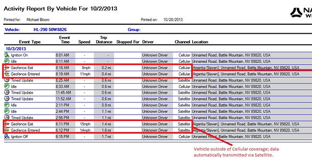
Navman Wireless USA today announced a new satellite communications option for its OnlineAVL2 fleet tracking platform, enabling continuous visibility of both heavy equipment and on-road vehicles even when assets are out of cellular coverage. Designed for construction, surface mining, mining and oil and gas exploration, and other environments with remote location work, the new solution includes the ability to minimize data charges by transmitting only the most critical event information via satellite.
Satellite connectivity is provided via a small modem that plugs into the serial port on Navman Wireless’ Qube on-highway or ruggedized Qtanium off-highway GPS tracking devices. The system automatically switches between cellular and satellite transmission with intelligent least-cost routing, using the global Iridium satellite network when fleet assets move out of cellular range. Benefits include:
Uninterrupted real-time fleet tracking without losing visibility of equipment location and other status information when assets are beyond the reach of cell towers.
Increased employee safety because equipment and vehicles are never out of sight of the fleet tracking system, even if they are working in cellular dead zones.
No missed engine alerts, potentially preventing costly machine repairs and downtime by ensuring that job supervisors are promptly informed when engine, coolant, transmission or air filter sensors connected to GPS tracking devices exceed pre-defined thresholds.
Cost-saving configurability, with the option to limit satellite transmissions to priority events (panic messages, rollover alerts, engine overheating, speed or geofence violations, etc.) and delay the transfer of low-priority event data until cellular coverage is restored.
“If a machine or vehicle in your fleet is operating outside of cell coverage and you have critical communications that need to take place for safety or operations reasons, it can be a problem to wait until the asset gets back into cell range,” said Davis Gammage, VP Product Management, Navman Wireless. “Temporarily switching to satellite communication solves the problem and ensures 100% visibility of your equipment as well as your field staff.”
The new satellite communications option marks the latest expansion of Navman Wireless’ fleet tracking portfolio for the construction, mining, and oil and gas industries. The company’s OnlineAVL2 fleet tracking platform provides location, operations and performance data for both on-highway vehicles and construction heavy equipment from a single interface. The back-end OnlineAVL2 application — delivered under the software-as-a-service model — includes industry-specific reporting such as jobsite utilization reports that break down equipment use by project, facilitate proper cost accounting, reduce writeoffs for unallocated asset hours, and aid in the development of future job bids for construction customers.
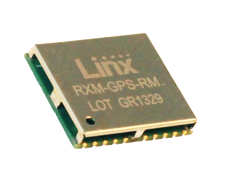
Linx Technologies announces its launch of the high-performance, low-cost RM GPS receiver modules. Using the built-in MediaTek MT3337 chipset, the RM module can simultaneously acquire on 66 channels and track on up to 22 channels, providing standard NMEA data messages through a UART interface. A simple serial command set can be used to configure optional features.
According to the company, the RM receiver module is a cost-effective GPS solution that offers no-frills, basic operation in a compact 15 x 13 millimeter package. The MediaTek MT3337-based RM Series is self-contained and only requires an antenna. It powers up and outputs position data without any software set-up or configuration, making the RM Series easy to integrate, the company said.
The receiver operates down to 3.0 volts and has a low tracking current of 12mA. The module has built-in receiver duty cycling that can be configured to periodically turn off the module for added power savings. This low-power consumption helps maximize runtimes in battery powered applications, such as consumer recreational positioning, marine, location and tracking, cargo tracking, and other asset monitoring systems.
In addition, the available GPS Master Development System connects a RM Series Evaluation Module to a prototyping board with a color display that shows coordinates, a speedometer and compass for mobile evaluation. A USB interface allows simple viewing of satellite data and Internet mapping, as well as custom software application development.
By Miguel Torroja, Steve Malkos, and Christophe Verne
Users of smartphones, tablets, and other devices expect position with the highest level of accuracy, always available, with the least amount of power consumed. One recent improvement fulfilling this demand involves operating-system services for location on smartphones, and the evolution towards lower power solutions.
“Please connect to a charger — The battery is getting low: less than 15 percent remaining.”
Handsets are battery-supplied devices, and a user’s tolerance for features is driven by battery consumption. There are many examples of technologies where users do not run certain hardware or features because it will consume the battery and make the phone useless within a short period of time.
The application processor (AP) of a handset device is very powerful, and is the part that consumes most of the battery life. Today’s smartphone multicore application processor is faster than many desktop computers that are just a few years old. Whatever the application, when it uses the AP, it can draw up to hundreds of milliamperes (mAs).
For the last few years, the trend for GNSS has been host-based positioning. Host-based designs have less logic on the GNSS integrated circuit (IC) and employ the host AP for a portion of the positioning computation. This strategy has three advantages:
Shares memory and code resources with the application processor.
Reduces the cost of the dedicated GNSS hardware.
Sharing the processor makes sense since it is already running.
Traditionally, when the GNSS solution was running, a navigation application that utilized the AP was also running.
However, when we only want to compute GNSS positions in the background, and we do not need a third-party application running on the AP, a host-based IC architecture is not the optimal solution with regard to system power consumption. This article explains some of the technologies used to compute a GNSS position using an ultra-low power (ULP) hybrid solution that combines the classic host-based GNSS architecture with a host-offload architecture that minimizes the use of the AP.
We discuss here two applications that benefit from a host-offload architecture: geofencing and position batching.
We will review the requirements for a platform to support a new hybrid GNSS positioning solution. Different host-offload technologies for geofence, such as GNSS, Wi-Fi, and Cell-ID, will be compared. Broadcom’s ultralow-power host-offload GNSS solution supports any operating system. We focus here on Android’s operating system because it is the most open OS.
Always-on Applications
Geofencing is an application that sends reports or triggers alarms when a predefined area is crossed. For example, users can be alerted to discounts with e-coupons when walking through a mall, or to “don’t forget the milk” — users can set their own reminder notifications based off of location; also, social networking. One example of location-based reminders is through Google Keep, which uses Android’s Geofence APIs on platforms that support hardware geofencing; this application will automatically take advantage of the hardware geofence solution.
Geofencing applications run in the background for long periods of time, and their main task is to compute positions (fixes) without the need of assistance from other applications. An ultra-low-power GNSS position solution, or always-on positioning solution, is desirable for these scenarios. Typical applications require notifications when entering or exiting a geofence area, or require periodic reporting of user positions relative to the fence.
Geofencing is not something new. API support has been provided in mobile OS for many years, but only now can it be used without draining the battery, thanks to this new host-offload architecture.
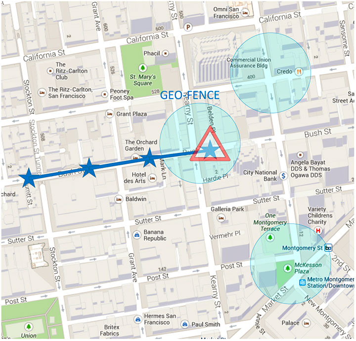
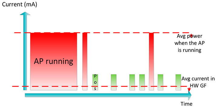
Figure 1 shows a circular geofence boundary and an alarm. In that example, the alarm was triggered when entering the fence.
Figure 1. Alarm when the vehicle enters a geofence area.
Breadcrumbing or position batching pertains to storing of positions, referred to as crumbs, which are accumulated for a certain amount of time and then pushed all at once to the application. Examples would be fleet or asset tracking applications, or people that wants to track their position while they are running.
Currently, Android does not support breadcrumbing as a native feature. There is some ongoing work, and APIs are being defined.
GNSS Positioning Models
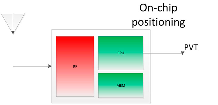
Before smartphones, the dominant GNSS hardware architecture employed a system-on-chip solution. The position/velocity/time (PVT) comes directly from the hardware, and all the computations are done in the GNSS IC.
On-Chip Positioning requires two things: a powerful-enough central processing unit (CPU) and lots of memory. The increase in CPU and memory performance are not free; they translate directly into more power and higher manufacturing costs.
The RF block in Figure 2 is intentionally drawn with a similar size to the CPU and memory, to emphasize the need for higher resources for a complete on-chip solution.
Figure 2. On-chip solution.
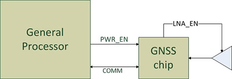
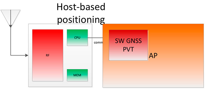
Host-Based Solution. GNSS positioning requires dedicated hardware, complex software, and protocols. This complexity led GNSS providers to move parts of the software out of the IC to the AP.
Using a mobile phone’s AP for position computation is one method of reducing the CPU and memory power footprint from the GNSS IC. At the same time, it also increases the power consumed by the platform needed to compute GNSS position, since part of the computation is not performed on the host-based IC. APs may consume approximately 100 mA just to be operational.
Figure 3 shows a typical configuration with dedicated GNSS hardware and a generic AP. In host-based mode, both the AP and the GNSS IC run in parallel when computing positions. The AP controls the GNSS hardware.
Figure 3. I/O connections in on-host positioning.
With this type of shared architecture, shown in Figure 4, the CPU and the memory on the GNSS IC are reduced, shrinking the size of the chip and reducing power consumed by the chip. In Figure 4 we see that the AP is communicating with the dedicated hardware, and the final PVT is computed by the AP. This solution fits well in many applications, such as navigation, where the AP has to run a mapping application at the same time.
Figure 4. Host-based solution.
Hybrid Positioning. For geofencing, we need a hybrid model, one which keeps GNSS IC complexity similar to the host-based architecture, but also offloads some of the host-based positioning so that the host can go to sleep.
In Broadcom’s hybrid mode, the AP does not need to run when GNSS positions are computed. Broadcom’s hybrid IC does not invoke the host AP often, and thus achieves an even lower power footprint. The CPU on the GNSS IC used for computing position is a dedicated one. It needs to be carefully chosen because it has to be powerful enough to compute positions and be as power efficient as possible. All this is done while keeping the GNSS IC area size in mind, to control cost.
Detailed analysis and steps were considered to ascertain the minimum requirements for the CPU and other resources to best accomplish the on-chip positioning task.
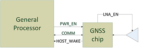
Other considerations: the GNSS IC must be powered even when the AP is suspended, and the GNSS IC must be capable of waking up the AP. Figure 5 shows a possible implementation using a dedicated I/O signal controlled by the IC to wake up the host AP.
Figure 5. I/O connections in hybrid positioning.
With this architecture, the host AP will still be needed to provide some assistance data to the GNSS IC. The assistance provided allows the GNSS IC to not invoke the host AP often and thus achieve an even lower power footprint.
Geofencing Methods
Certain OS application APIs have been supporting geofencing for many years. Currently, we can find geofencing APIs in most of the mobile OSs in the market.
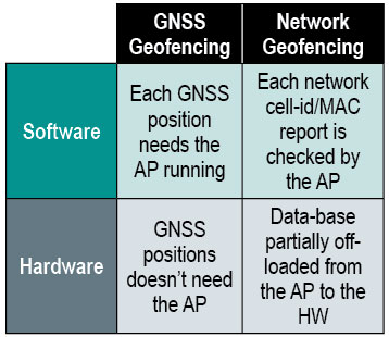
There are four main types of geofencing: GNSS software geofencing, GNSS hardware geofencing, network software geofencing, and network hardware geofencing (Table 1).
Table 1. Geofencing methods.
GNSS Hardware Geofencing. In this method, the one described in detail in this article, the OS initiates a request and offloads the areas of interest to the hardware. After that, the AP can go to sleep and the hardware is responsible for computing positions and checking the areas of interest. This method basically relies on GNSS hardware to compute positions and check the programmed fences.
GNSS Software Geofencing. Here, the OS initiates regular fixes to a host-based GNSS IC design. Then it invokes both the AP and the GNSS IC at the same time to check against the defined fence areas.
Network Geofencing. In this method, the OS requests network IDs from the hardware (that is, baseband modem Cell-ID and Wi-Fi access points). The OS uses different positioning technologies to compute position. This usually requires a connection to a server to retrieve location information about the different IDs. The position is used to check the geofences.
In network hardware geofencing, a set of network IDs is offloaded from the OS to the network hardware ICs. The hardware can poll for these IDs, and wake up the host when found.
Network versus GNSS Geofencing
A good geofencing solution combines both network and GNSS methods because each solution benefits from each other.
GNSS positioning solutions compute positions in open-sky environments with accuracy to a few meters and have worldwide coverage. However, they cannot work in deep indoor spaces.
Network geofencing using cell IDs is quite inaccurate, but works very well indoors. Network geofencing using a Wi-Fi access point provides reasonable accuracy, but location of the access points is not always known and it does not have full coverage.
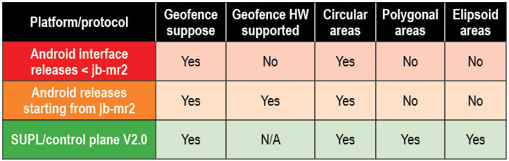
Geofencing in Android 4.3. The API for applications supports geofencing. Starting from the first version of Android, the application just initiates a proximity alarm and will get an event when its boundaries are crossed. The OS is responsible for notifying the application when such an event occurs, and can use any technologies it sees fit.
The API that applications use is very simple. The monitoring is handled by the OS and is hidden to the application (for example, technologies, periodicity of checks, and accuracies).
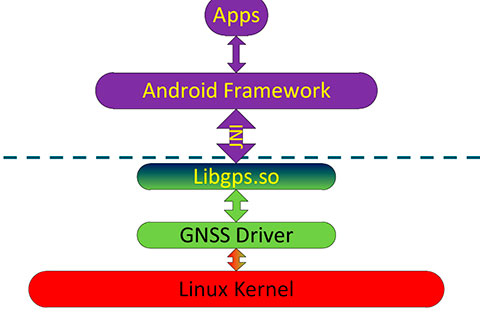
Software Geofence in Android. Software geofencing has been the default method until recently, as there was no native hardware support. In this mode, the host-based GNSS positioning engine is started like any other position request. The Android framework is the one dealing with the monitoring of the geofences, and therefore, the AP must run continuously to handle periodic position checks. That means the software-geofencing logic is mainly in the framework layer of Android (see basic layers diagram shown in Figure 6).
Figure 6. Android framework.
More recent versions of Android dropped the support for software-based geofencing in favor of a host-based GNSS system, likely because of the big impact on the battery. Broadcom developed a low-power GNSS hardware solution for geofencing.
Hardware Geofence in Android. Starting from Android 4.3, a new interface is available to use hardware geofencing. This interface is not visible to the application, and it is only used as a low-level interface. To support the new hardware-geofence interface, the native driver only has to register to a new GNSS interface defined in the native hardware abstraction layer (HAL) of Android.
There are other protocols known to support geofencing. Table 2 provides a short list.
Table 2. Geofencing support on different platforms.
Broadcom Hybrid Positioning
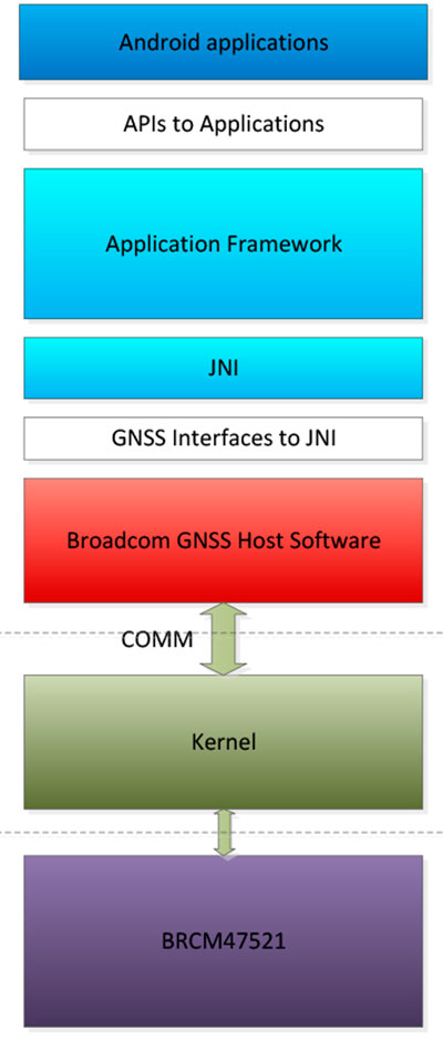
Android defines interfaces to the hardware, referred to as the HAL.
GNSS Host Software. GNSS providers need to comply to the HAL interface, which is at the Java native interface (JNI) level. Below the JNI lies the GNSS host software (Figure 7).
For the host-based solution, the GNSS host software handles most of the heavy computing.
For the hybrid solution, the GNSS host software does some of the heavy computing, but positions are computed inside the GNSS IC.
To support this new hybrid solution, two main changes are required compared to the usual host-based solution, as described below.
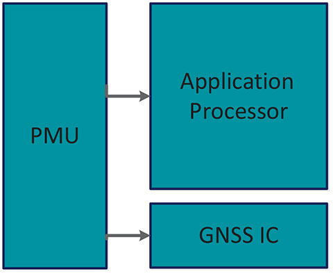
First, the hybrid GNSS IC must be autonomous while the host AP is sleeping. This implies that some power domains are maintained when the GNSS is in use. This typically means at least one of the outputs of the power management unit (PMU) should be dedicated to the GNSS only (Figure 8).
Figure 8. Power domains.
Second, the GNSS IC must be able to wake up the host AP so as to send geofence notifications, or to request assistance data. This is usually done through a dedicated pin.
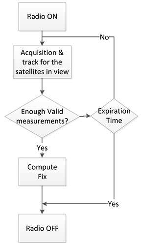
Acquisition and Sleep Period. Most of the power in the GNSS IC is used by the radio and analog part. To reduce power, this part is switched on only during acquisition. As soon as enough measurements are observed, the radio part is switched off while the digital part computes a fix.
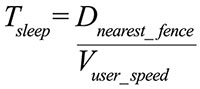
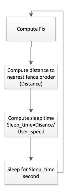
After each computed position, the GNSS IC can go into a deep power-saving mode until the next acquisition. The distance to the closest fence in conjunction with the user speed is used to determine when to compute the next position (Figure 9):
Figure 9. Start fix decision logic.
Once the GNSS IC starts computing positions, the AP can go into sleep mode (Figure 10). Total power per position computed is reduced, and the time between fixes is no longer constant, as shown in Figure 11.
Figure 10. Sleep time between fixes.Figure 11. Duty cycling.
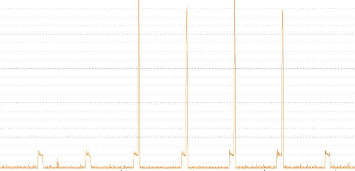
In Figure 12, the lower square-shaped pattern corresponds to a position computation from the hardware GNSS IC. Once we have an alarm, the host has to be woken up and we can see the impact in power in the big peaks after a position is computed.
Figure 12. Power graph.
Alarm Triggering
When a geofence area is crossed, the GNSS IC needs to wake up the AP. This is achieved using a dedicated interrupt pin. After asserting it, an alarm and geofence status is sent to the AP.
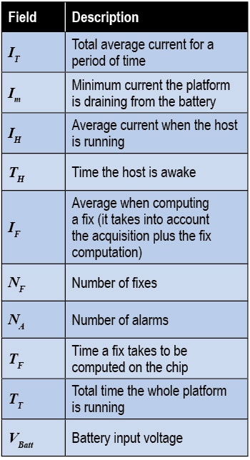
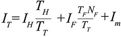
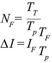
Power Consumption. We calculate the total average current by splitting it into three components, as shown in the following formula:
Some of these parameters are set by the host: for example, how often the fix should be computed. The extra current drained by the GNSS IC is the one defined by
∆I is the change in current drain when computing positions.
We can also express this formula based on the average number of position attempts:
where Tp is the average time between fixes (the time the GNSS IC stays in sleep).
Table 3 illustrates some theoretical ∆I current savings with respect to Tp.
Conclusion
As APs become faster and faster, their power consumption goes up. A novel hybrid GNSS receiver has been presented, which offloads some of the host-based processing into the GNSS hardware, offering ultra-low system power consumption versus the traditional methods. The new hybrid positioning solution is a good approach for always-on applications that need to have location information always available, without requiring the host to be running, as is the case with geofencing and breadcrumbing.
References
We would like to thank Jason Goldberg, Frank van Diggelen, and Manuel del Castillo, all of Broadcom, who reviewed this article and spent many hours with us discussing the topics point by point.
Miguel Torroja is a principal software developer at Broadcom. He has an M.Sc. in electrical engineering from Ramon Llull University, Barcelona. Since 2011, he has been working on the design and development of algorithms for optimizing power consumption in GNSS host-offload solutions.
Steve Malkos is a senior program manager at Broadcom. He has a B.S. in computer science from Purdue University. He has been active in the development of A-GNSS technologies such as hybrid location services, long-term predicted orbits (LTO), Broadcom’s worldwide reference network (WWRN), and secure user-plane location (SUPL). He has five patents issued and 16 pending.
Christophe Verne is a manager of software engineering at Broadcom. He has an M.S. in electrical engineering from Ecole Centrale, Paris. He has been involved in the development of GNSS and A-GNSS technologies at EADS, Sagem, Global Locate, and Broadcom, where he has been working on low-power host-offload positioning.
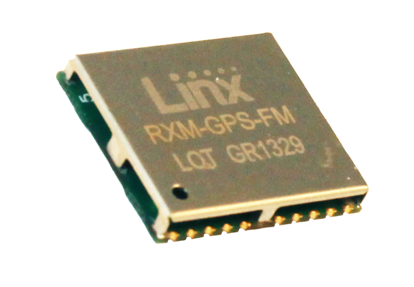
Linx Technologies announces its launch of the self-contained, high-performance FM GPS receiver modules. At 15 x 13 millimeters in size, the MediaTek MT3339-based FM Series gives the module fast lock times and high position accuracy even at low signal levels, the company said.
The module’s very low power consumption helps maximize run times in battery powered applications, such as positioning and navigation, location tracking, marine, and asset management, according to Linx Technologies.
Using the built-in MediaTek MT3339 chipset, The FM module can simultaneously acquire on 66 channels and track on up to 22 channels, providing standard NMEA data messages through a UART interface. A simple serial command set can be used to configure optional features.
The GPS receiver is completely self-contained and only requires an antenna. It powers up and outputs position data without any software set-up or configuration. As a result, the FM Series is easy to integrate, the company said.
With built-in hybrid ephemeris prediction technology, the FM Series predicts satellite positions for up to three days and delivers start times of less than 15 seconds under most conditions.
In addition, the available GPS Master Development System connects a FM Series Evaluation Module to a prototyping board with a color display that shows coordinates, speedometer and compass for mobile evaluation. A USB interface allows simple viewing of satellite data and Internet mapping, as well as custom software application development.
Roadnet Technologies, the Baltimore-based transportation logistics software firm, announced today that the MobileCast Proof-of-Delivery application is now available in Apple’s iTunes App Store. The introduction of the proof-of-delivery application for Roadnet customers using Apple products allows the ability to integrate delivery services into a single mobile platform.
The MobileCast Proof-of-Delivery app includes:
GPS Tracking
Manual Arrive/Depart to track accurate service times
Text Messaging within the application to streamline communications
Dynamic Dispatch of stops to driver’s mobile device
In-Field Geocoding to ensure accurate delivery locations
Store and Forward so that when a coverage issue is experienced all information will be saved and transmitted later
Driver Re-Sequencing of stops to allow control over reordering stops when necessary
Order Summary to quickly view what is being delivery
Apple Maps integration to provide delivery driving directions (does not include truck restrictions)
Apple Voice Navigation provides audible directions to a requested location
Apple Live Traffic overlays to provide traffic information for the route
On Track, the sales and merchandiser tracking application that accurately records mileage and time spent with a customer, is also available within the MobileCast app.
The MobileCast phone solution is a proof-of-delivery application. Proof-of-delivery systems not only let management track their vehicles in real time, but they also notify employees in the back office when issues arise that may prohibit a route from being completed as planned. The historical data collected through a proof-of-delivery application can also be used to evaluate trends and determine alternative solutions for route execution.
According to a new research report from the analyst firm Berg Insight, the number of active fleet management systems deployed in commercial vehicle fleets in Europe was 3.05 million in Q4-2012. Growing at a compound annual growth rate (CAGR) of 16.0 percent, this number is expected to reach 6.40 million by 2017. A group of international aftermarket solution providers have emerged as the leaders on the European fleet management market. Masternaut is ranked as the largest player overall in terms of installed base with close to 287,000 units deployed today. TomTom Business Solutions was the fastest growing vendor also in the past year and has now surpassed 275,000 subscribers in this region. Digicore and Trimble have also joined the exclusive group of fleet management providers in Europe having more than 100,000 active devices in the field. Transics is number one in the heavy trucks segment with an estimated 80,000 active units installed.
A major trend in the past two years has been the announcements of standard line fitment of fleet management solutions. Since the end of 2011, Scania is rolling out the Scania Communicator as standard on all European markets and includes a four-year basic service subscription. The new generation of the Actros trucks from Mercedes-Benz contains the FleetBoard vehicle computer as standard in all EU27 countries since October 2011. Volvo is going in the same direction offering Dynafleet as standard in Europe. MAN TeleMatics is since July 2012 standard on the new truck model TGX EfficientLine.
A second wave of M&A activities started in 2013 after 18 months of lull. “Six major mergers and acquisitions have so far taken place this year among the vendors of fleet management systems in Europe”, said Johan Fagerberg, Senior Analyst, Berg Insight. Danaher Corporation is betting on the fleet management market and acquired Navman Wireless and Trafficmaster from Prairie Capital and Vector Capital respectively. TomTom made its second acquision in the fleet management space when picking up Coordina headquartered in Spain. The latest transaction was done in September 2013 when Oskando and Autolog merged and at the same time launched the new brand EcoFleet. Mr. Fagerberg anticipates that the market consolidation of the still overcrowded industry will continue in 2014.
ORBCOMM Inc., and Savi Technology have announced a strategic relationship to provide advanced location-based monitoring solutions to government and commercial markets.
ORBCOMM is a global provider of machine-to-machine (M2M) solutions, and Savi Technology is a provider of sensor-based analytics and radio-frequency identification (RFID) solutions.
ORBCOMM and Savi have submitted a proposal in response to the U.S. Army RFID IV project, which will provide both ISO18000-7 RFID tags and a suite of satellite solutions for military logistics support. ORBCOMM’s GlobalTrak division has been a leading player in providing military Enhanced-In-Transit-Visibility (EITV) solutions to the government market since 2008, and Savi has been a market leader in military RFID solutions, enabling it to offer vast market experience with the right blend of technology platforms for this proposal.
“The combination of ORBCOMM’s satellite expertise and broad network service portfolio with Savi’s state-of-the-art RFID technology offers a full spectrum of innovative monitoring solutions to our collective market base with focus on our government and international customers,” said Marc Eisenberg, Chief Executive Officer of ORBCOMM. “Although RFID and satellite tracking have traditionally been divergent technologies, the synergy of these solutions within a common operating environment creates a seamless transition from infrastructure to wireless-based location services for tracking and monitoring high-value assets.”
“By bringing two market leaders with highly complementary technologies together, we have created a best-of-breed solution for our customers in both government and commercial markets,” said Bill Clark, chief executive officer of Savi Technology. “This relationship will support Savi’s operational analytics capabilities by providing additional ways to collect critical data and deliver timely and reliable operational intelligence to our customers. We look forward to partnering with ORBCOMM on RFID IV and other global opportunities in the near future.”
XRS Corporation, a mobile trucking intelligence company, has announced that Verizon is the official wireless provider for its new collaboration with Samsung Telecommunications America. The new product — NXT — creates what XRS says is the first integrated mobile device and software package designed specifically for the trucking industry.
The new solution brings together powerful XRS compliance and performance tools with Samsung Mobile’s devices, XRS said. Now, NXT is powered by the Verizon 4G LTE network, which provides the platform with superior performance and speed.
“Technology forces in the trucking industry have long been on converging paths, and our new NXT product — powered by XRS in collaboration with Verizon and Samsung Mobile – is a perfect example of how our industry is harnessing the power of technology to benefit drivers and fleet managers,” said Christian Schenk, senior vice president, XRS Corporation. “An integrated platform is the next evolution of convergence, and we are proud to be working with industry leaders like Samsung Mobile and Verizon to deliver the ultimate trucking intelligence solution.”
NXT allows drivers and fleets to purchase select Samsung Mobile devices with an XRS trucking intelligence software subscription and ready for activation on the Verizon 4G LTE network. The first device available is the Samsung Galaxy Tab 7.0, priced at a $100 discount from its suggested retail value. The data plan and subscription cost is $54 per month, including $39 for the monthly XRS fee and $15 for the monthly wireless data fee. This charge covers all required subscriptions and data, including the Relay onboard hardware component, as well as FLX messaging, hours of service, electronic DVIR, IFTA state mileage reporting and more.
“With the explosive growth of mobile electronic devices in the trucking industry, drivers have come to expect reliable and fast wireless service while they are on the road,” said Michael Toto, director of alternate channels for Verizon Enterprise Solutions. “This solution is one example of how Verizon is investing in the success of our channel partners as we collaborate to bring new innovative solutions to the market.”
NXT also offers integration with many enterprise transportation products. Over time, the platform collaboration will expand to introduce additional components, including MDM and wearable products.
The XRS trucking intelligence platform operates in both over-the-road and private carrier configurations, and is suitable for fleets of all sizes. XRS runs on certified smartphones, tablets and rugged handhelds that transmit vehicle and operator data through the cloud to a fleet management dashboard, helping companies to comply with current regulations and soon the pending Electronic Logging Device (ELD) mandate for electronic recording of a driver’s hours-of-service. Nearly 90 percent of drivers already use mobile devices while on the job.
NXT was developed through the Samsung Solutions Exchange, a newly announced strategic engagement model from Samsung Mobile that delivers a range of end-to-end solutions that address real world business challenges. The program is aimed at achieving shared value across Samsung Mobile’s rapidly growing ecosystem of enterprise customers, sales channels and alliances.
“NXT is a holistic solution for trucking that addresses performance, safety, and compliance challenges unique to the industry,” said Tim Wagner, vice president and general manager, enterprise business unit – Samsung Mobile. “Through the Samsung Solutions Exchange, we have worked closely with XRS and Verizon to enable a solution that leverages our respective strengths – which for us includes our robust suite of enterprise-grade devices.”
Customers can buy the NXT product either directly through Verizon or through XRS.
Spireon, a Mobile Resource Management (MRM) and Business Intelligence Solutions provider, has completed an initial phase of the integration of its industry leading GoldStar GPS solution with Frazer’s Dealer Management System (DMS).
Frazer is a provider of software solutions that auto dealers across the nation use to grow their business and increase their productivity, including its comprehensive DMS, which has functions such as dealer inventory management, credit application processing, electronic contracting, set up bank contracts and BHPH deals, dealer management tools, loan servicing and accounting systems.
Joint customers of GoldStar GPS and Frazer can now experience online access to a single solution to execute critical commands. The integration allows dealers to execute commands directly from their Frazer application, interface saving customers time and improving their ease of use. Dealers can monitor and take action on their collateral within their day-to-day dealer management application. Key features of the initial phase of integration include the ability to conduct an on-demand locate, and disable and re-enable the starter interrupt.
“Spireon’s new partnership with Frazer is another example of Spireon’s ongoing quest to improve the ease of use of our solutions through key partnerships to enhance the customer experience for effective collateral management, vehicle tracking and risk mitigation. GoldStar GPS and Frazer users will experience a platform that will allow them to do more.” Explains David Meyer, Executive Vice President of Spireon.
“We have watched the incredible growth of GoldStar GPS and are very excited about now offering Goldstar GPS as an integrated feature within the Frazer DMS. This will make a lot of dealers’ lives just a little bit easier.” Michael Frazer, President.
 Niche markets for location companies are sometimes hit-and-miss. One real opportunity that is gaining more traction among location companies is towing. There are legions of Duck Dynasty-type of towing trade show attendees, but you shouldn’t judge a book by its cover. There is tons of money in the towing industry as banks, insurance companies, motor clubs and other technology entities are flocking to these shows. Many times that scruffy-looking guy in a Duck Dynasty T-shirt is a multi-million-dollar owner of a big towing company. Companies such as Verizon are ramping up their fleet opportunities for more conventional markets, which leads one to say, once again, that the fleet, mobile resource management market is still growing and lucrative.