Tag: fleet management

  • Blue Sky Network Debuts Portable M2M GNSS Tracking Solution

    Blue Sky Network Debuts Portable M2M GNSS Tracking Solution

    Blue Sky Network's HawkEye 7200 Portable M2M Tracking Solution.
    Blue Sky Network’s HawkEye 7200 Portable M2M Tracking Solution.

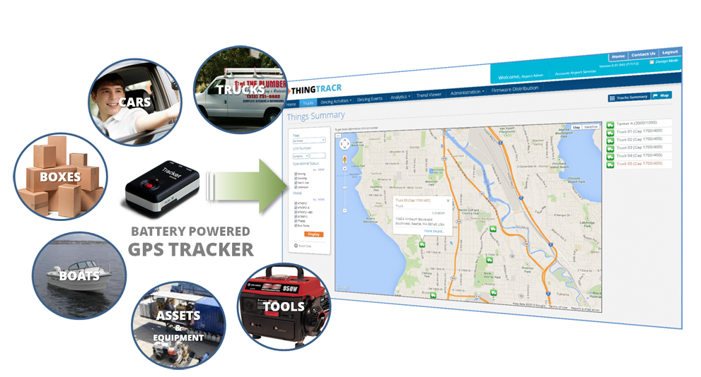
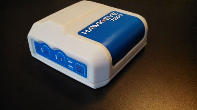
    Blue Sky Network, a supplier of satellite tracking and communication solutions for aviation, land and marine, has launched the HawkEye 7200 portable M2M tracking solution. The HawkEye 7200 includes features such as multinational GNSS receiver support and integrated Bluetooth for Iridium connectivity to smart devices. Designed in a small form factor, the HawkEye 7200 can be powered by battery or via an external power source and is a key addition to Blue Sky Network’s solutions portfolio extending the reach of smart device communications globally anywhere in the world.

    The HawkEye 7200 is Blue Sky Network’s first product to incorporate a multinational GNSS receiver. It combines the major GNSS providers into a single location-based chip that can be used in other parts of the world including GLONASS for Russia and the Galileo for the European Union. This multinational GNSS receiver feature enables fleet operators with globally dispersed assets to obtain position reports with increased accuracy and performance. When used with New SkyRouter, Blue Sky Network’s cloud-based web-portal, the HawkEye 7200 offers portable tracking and resource management of any asset type across the globe. The HawkEye 7200 hosts an RS232 interface and digital inputs/outputs for connectivity and control of external sensors or other telematics devices.

    With the integrated Bluetooth connectivity, the HawkEye 7200 supports Blue Sky Network’s new iPhone/iPad application. The application allows users to send emails, short-code messages and customizable electronic forms through the Iridium network. With the ability for operators to build and fully customize forms — such as flight plans, maintenance records and logistic records of remote assets — HawkEye 7200 supports the industry’s movement toward paperless fleet operations.

    “Blue Sky Network is a long-time member of the Iridium partner ecosystem and is continuously delivering cutting-edge M2M communication solutions targeting new markets,” said Bryan Hartin, executive vice president, commercial sales and marketing of Iridium. “The HawkEye 7200 is yet another solution from Blue Sky Network that offers powerful capabilities and applications that utilize the Iridium network. Together we are providing customers with critical connectivity worldwide.”

    “The HawkEye 7200 further bolsters our leadership position in the mobile resource management and tracking industry,” said Blue Sky Network’s CEO and founder, Jon Gilbert. “Combining our HawkEye 7200 with our iPhone/iPad application and our industry-leading backend web portal, New SkyRouter, our customers have a complete end-to-end solution to link the far reaches of the world right in the palm of their hand. We are shrinking the global communication barrier and improving the methods by which people anywhere make connections to manage critical assets and communicate.”

    Blue Sky Network is showcasing the HawkEye 7200 at the Helitech International Helicopter Expo & Conference, in London on September 24-26, in booth #B59.

    The new HawkEye 7200 is in process of being certified by Iridium, with production expected in Q4 2013.

  • GPSTrackIt Announces New Analytics Dashboard

    GPSTrackit’s Fleet Manager Software now features an Analytics Dashboard that enables fleet managers to monitor and review fleet performance by reviewing historical data in a series of charts and graphs. Fleet Manager is a robust application providing fleet owners and managers with a comprehensive suite of integrated tools, GPSTrackIt said.  The system delivers real-time GPS vehicle tracking, vehicle maintenance scheduling, and a wide range of alerts. The Analytics Dashboard brings to the system a new array of powerful and flexible capabilities.

    “It puts the information fleet managers and owners need at their fingertips,” said Eddie Bermudez, GPSTrackIt’s product manager.  “We already provide all the historical data via the reports system. This new feature brings that data to life with dynamic graphics.”

    The dashboard displays up to six charts, which can be configured as bar charts or pie charts. Each chart can focus on particular issues important to fleet owners, managers and dispatchers: Idle Time, Drive Time, Stop Time, Speeding and Mileage.

    “The charts can be configured to show data for all units or a single group,” explained Bermudez. “Or a chart can compare groups by displaying their data side-by-side using different colors.”

    In addition, three composite charts are available; Engine Time, which monitors idle time and driving time; Driving Overview, which monitors idle time and driving time and stop time; Idle Stop, which monitors idle time and stop time. The time metric determines which historical data is used. Options available are week, month, quarter, and year.

    “Charts can be rearranged on the dashboard by dragging and dropping,” added Bermudez.  “And there are several additional options that can be configured. Chart labels of up to 25 characters can be added. The start of day can be set to any of the 24 hours. For bar charts, the average value can be shown superimposed on the graph.”

    Bermudez continues, “The Analytics Dashboard can also display the highest or lowest values for a given graph. This can be configured to show values from one to 20. Selecting Highest and a numerical value of five on an Idle Time chart, for example, displays the five vehicles with the highest values for idle time.”

    “This is important for fleet managers to know because of added fuel consumption, as well as vehicle wear,” according to Bermudez.  ”Selecting Lowest and a numerical value of ten on a Speeding chart shows the ten vehicles with the lowest incidence of speeding.”

  • Qualcomm to Sell Fleet Management Unit for $800M

    Qualcomm to Sell Fleet Management Unit for $800M

    Logo: OmnitracsQualcomm Incorporated has signed a definitive agreement to sell its fleet management and tracking business Omnitracs to Vista Equity Partners for $800 million in cash.

    The acquisition will include all of Omnitracs operations in the U.S., Canada and Latin America, including Sylectus and FleetRisk Advisors, which were acquired by Omnitracs in 2011. The transaction is expected to be completed during the first quarter of Qualcomm’s fiscal 2014.

    Omintracs, formerly known as Qualcomm Enterprise Services, provides integrated fleet management applications, services and platforms to transportation and logistics companies. The company provides solutions for safety and compliance, driver retention, GPS fleet tracking, and fleet maintenance software.

    “In the late 1980s, Qualcomm pioneered the use of commercial vehicle telematics with the introduction of the first mobile information system for transportation and logistics,” said Qualcomm executive vice president Derek Aberle. “As one of Qualcomm’s earliest businesses, Omintracs has maintained a leadership position within the industry for 25 years. Today, the opportunity for fleet management and telematics is evolving rapidly, and we believe Omnitracs is well positioned to continue its leadership position as a stand-alone entity.”

    “We are long-term investors in enterprise software, data and technology-enabled businesses that are committed to being leaders in their fields,” said Robert Smith, chief executive officer and founder of Vista Equity Partners. “We are impressed with the compelling value proposition Omnitracs’ products and services offer their customers. We look forward to working with them and helping them to reach their full potential.”

    The closing of the transaction is conditioned upon, among other things, clearance under the Hart-Scott-Rodino Antitrust Improvements Act of 1976 and other customary closing conditions.

  • Mobile Resource Market Shows Largest Growth in Location Industry

    Mobile resource management has never been a sexy market full of buzz and excitement — we are talking tracking trailers and containers. However, it is on pace to see double-digit growth through 2020. Led by a handful of companies in local fleet, long haul, cellular and trailer tracking, MRM has never faced ups and downs like other location market segments. In fact, acquisitions and growth appear to be in the future for this market segment.

    With more than 5.7 million tracking units nationwide, and 9 million more expected to be sold by 2015, the mobile resource management market continues to be one of the steadiest, and profitable, location businesses.

    In one of the bigger MRM deals earlier this month, Danaher Corp. purchased Garden City, California-based Teletrac, which was owned by Vector Capital. Teletrac, which offers a cloud-based software as a service (SaaS), has units installed in more than 200,000 vehicles in 87 countries.

    In terms of segments within MRM, the local fleet market continues to be the largest, according to Clem Driscoll, president of CJ Driscoll and Associates, who is completing a multi-client study of U.S. fleet operators that is sponsored by two major wireless carriers.  Local fleet operators had more than 3 million units installed in 2012. In 2000, local fleet companies had about 250,000 units installed, according to Driscoll.

    Another growing MRM market segment include cell-phone-based systems with 1 million units.  Long-haul trucking and trailer tracking both have less than 1 million units installed in 2012. The major players in long-haul trucking markets have included Qualcomm, PeopleNet and XRS (Xata), but Qualcomm just announced that it is selling its fleet management and tracking business Omnitracs to Vista Equity Partners for $800 million in cash.

    Driscoll says the largest GPS fleet management company is Fleetmatics, which recently went public, raising $94.3 million. The company has 331,000 units installed worldwide, and had $127.5 million in revenue last year.

    Driscoll has identified several MRM trends: hardware prices are declining, MRM service providers are bundling the hardware; leveling off of equipment purchases for local fleet markets as suppliers transition to third-generation devices; increased integration with Android; smartphones and tablets; and more acquisitions.

    Speaking of acquisitions, the past year was a busy one for MRM. Telogis bought Maptuit and NavTrak. CalAmp bought Wireless Matrix, which is a GPS-cellular tracking company.

    For long-haul trucking acquisitions, the biggest deals came from Trimble, which purchased TMW Systems, ALK Technologies and GEOTrac, an oil and gas monitoring company.

    In Europe, the United Kingdom and France could see growth, but Spain has economic problems. Germany still is a strong long haul market, Driscoll says. In Asia, there should be 9 million potential units sold in the next few years, with China being the dominant player. Korea and Japan are maturing markets.

    Overall, by 2020, MRM could achieve the same level of penetration as the smartphone market.  Today’s smartphone may be the ultimate telematics equipment, and future MRM equipment of choice, as the automotive OEMs have found out by listening to their consumers, Driscoll said.

    Google Maps Already Using Waze 

    In other location industry news, Google Maps this week is using Waze real-time traffic reports on its app for Apple iOS and Android, according to a blog post from Google. The announcement constitutes the first significant use of the Waze app since Google purchased the Israeli startup for $1 billion in June.

    While Google Maps users will be able to use reports about accidents, construction and road closures, Waze consumers will be able to get access to Google search and Street View. According to published reports, more than 15,000 new map editors joined the Waze editing community this month, which is a 43 percent month-over-month increase.

    Intel Shuts Down Telmap

    Late last month, after our LBS Insider deadline, Intel announced it was shutting down Telmap, an Israel-based company it acquired in 2011 for a reported $120 million. The move signals the end of Intel’s navigation business, which had hoped to offer end-user tools and white label technology for developers.

    Telmap employed 150 people at its development center in Herzliya, Israel, and had dozens of other employees at various Intel branches throughout Europe and the United States. Telmap rolled out a free navigation app called M8, which was launched earlier this year. The app drew revenue from advertising and was marketed to wireless carriers for rebranding.

    In Israel, Orange, Cellcom and Pelephone, the country’s largest wireless carriers, all use Telmap’s white-labeled product, according to published reports.

    According to published reports, some of the Telmap employees will be placed in other positions within Intel Israel. The reports said that Intel was too late with its free app and was way behind crowdsourced traffic providers such as Waze.

    Telmap, founded in 2000, was viewed as an up-and-coming player in the location industry. It supported wireless carriers mainly outside of the United States such as Orange FT Group, SingTel, MTS, Vodafone, Vodacom, SFR, Telefonica-02 and others. Its U.S. partners included Nokia (Navteq), MapQuest and Inrix.

    Is the Location Industry Conference Dead?

    After working overseas for nearly a year, I have noticed that there are not a lot of industry events to cover, particularly pure location conferences. There may be a connected vehicle panel at the Consumer Electronics Show or a CTIA trade show.

    However, the location-centric conference appears to have died in the wake of industry consolidation (and Google’s giving navigation away for free). Replacing these conferences are connected vehicle and insurance telematics conferences that feature an occasional wireless, or LBS, panel.

  • iTRAK Integrates Navigation and Wireless GPS Fleet Tracking

    iTRAK Integrates Navigation and Wireless GPS Fleet Tracking

    Photo: iTRAK Corporation

    iTRAK Corporation, a provider of GPS-based wireless fleet tracking, has integrated the patented iTRAK Fleet Executive (iFE) cloud-based software, the iTRAK WebApp software for tablets and smartphones, and iTRAK’s wireless GPS tracking equipment with the Magellan RoadMate Commercial 5190T-LM fleet navigation unit. The combined product will allow remote tracking of vehicles and handsets in the field, while integrating with the Magellan commercial product to provide in-cab navigation voice prompts and terminal text messaging.

    The new product, combined with a heavy duty engine interface, will meet the new and emerging EOBR/ELD standards, while providing customers with the flexibility, efficiency and reduced liability required by today’s professional carriers and heavy duty equipment operators.

    “Magellan is pleased to have iTRAK as a partner integrating the Magellan RoadMate Commercial 5190T-LM in their offer combining navigation, messaging and fleet tracking,” said Mark Perini, associate vice president of Product Marketing for Magellan.

    The combined system provides fleet tracking using iTRAK’s patented iTRAK Fleet Executive (iFE) and iTRAK WebApp to remotely track vehicles and handsets in the field, while integrating with the Magellan RoadMate Commercial 5190T-LM commercial product to provide in-cab voice navigation and terminal messaging through the iFE cloud-based application. Features include:

    • Five-inch WVGA touch screen.
    • Customizable truck routes.
    • The truck road attributes can be turned off, so drivers can use the same navigation device in their personal passenger vehicles.
    • Free lifetime traffic alerts.
    • Multiple stop routing.
    • Hours of service tracking.
    • Optional engine interface: Both OBD-II and J1939 interfaces are supported. Engine data can be transmitted to the office by the iTRAK system.
    • Loud (93-dB) speaker.
    • Messaging to and from the vehicle.
    • Truck-specific POIs such as weigh stations and truck stops.
    • Bluetooth: The navigation device includes Bluetooth capability, to pair with and serve as the speaker for a smartphone.
    • Ability to phase implementation: The system is modular so it can be implemented in stages to help drivers adjust to the new technology

    The combined product will provide affordable and safe fleet tracking, communication and navigation functions for commercial trucking, service vehicles, government, sales fleets and much more.

    For more information contact iTRAK at 719-686-0100, or e-mail [email protected].

  • Trimble TirePulse System Monitors Fleet Health

    Trimble has introduced the TirePulse Tire Monitoring System to assist fleet managers in reducing maintenance costs, increasing overall fleet productivity and promoting site safety. Part of the Trimble Connected Site portfolio, the advanced machine monitoring solution wirelessly reports tire temperature and pressure data from the jobsite to the VisionLink fleet, asset and site productivity management solution from Trimble. Automatic, real-time tire pressure and high-temperature alerts help fleet managers and site supervisors schedule cost-effective preventative tire maintenance, extend the life of tires, increase fuel efficiency and avoid dangerous blowouts.

    Under-inflated tires can reduce fuel economy, increase overheating, tread wear and blowouts that take a machine out of production. Together, these factors can significantly affect fleet productivity and operating costs.

    Trimble TirePulse can improve tire life while also reducing the need for fleet managers to drive to the site and visually inspect inflation, tire wear and temperature. Using a Trimble TP920 Industrial Tire Sensor in the tire valve stem and a Trimble SNM940 Connected Site Gateway for communications, the information is automatically relayed back to the office for analysis by the fleet manager. Accurate data is communicated through VisionLink, so the fleet manager can proactively manage tire maintenance on more machines across construction sites. Better preventative maintenance can result in improved fleet costs.

    The Trimble TirePulse system also promotes increased jobsite safety by reducing the risk of tire blowout and injury to workers. Properly inflated tires improve the performance of vehicle braking systems and allow a faster response time in potentially dangerous conditions. The system is also safer and more accurate than manual visual inspection because it does not require personnel to be in close proximity to overheated tires on heavy machinery.

    VisionLink automatically alerts the fleet manager or site foreman when a tire experiences a 20 percent drop in pressure and becomes a potential hazard. It can also provide a high-temperature alert to indicate that jobsite conditions are likely to accelerate tire breakdown.

    “Preventative maintenance is more cost effective than a machine going down suddenly with a blown tire. But with equipment moving around so much from site to site, fleet managers struggle to stay ahead of the game,” said Julian Dann, business area director for machine control. “TirePulse is priced for installation across the entire fleet of on- and off-road machine tires, regardless of make, model or manufacturer. Increased wear or breakdown can be reported and acted upon proactively. The system can often pay for itself by preventing just one blowout.”

  • SeeControl Announces ThingTracr GPS Tracking Tool

    SeeControl Announces ThingTracr GPS Tracking Tool

    SeeControl-trackr
    Source: SeeControl

    SeeControl is announcing the roll out of ThingTracr, a hosted SaaS GPS tool for monitoring anything that needs to be tracked. The simple-to-use solution offers precise location tracking and historical analytics reporting for things of interest using a small and attachable GPS unit that requires no tools or wiring. The tracking service can be up and running in less than five minutes.

    Using web browsers or mobile devices, a user can easily monitor the status of the tracked asset. It can be used for cars, trucks, trailers, packages, site equipment or anything else.

    “There are several unique features that set ThingTracr apart from other tracking services,” said Bryan Kester, CEO of SeeControl. “One is a modifiable modern dashboard that allows users to personalize how they view the tracking information in the most convenient way for them. Another is the ability to upgrade and expand to new GPS trackers globally as they come on the market.”

    Other features of ThingTracr include:

    •     90-day location history
    •     User customizable dashboards
    •     Low battery alarms
    •     Satellite / hybrid map views
    •     Multiple reports
    •     Data export – CSV/ PDF
    •     Trip Reports
    •     Range of pre-certified hardware
    •     Trip replays on maps

    ThingTracr uses various battery-powered GPS devices, which can also notify users of several alarms including motion detected, speeding, and information regarding battery life.

    The ThingTracr GPS tracking tool is just one of many vertical solutions available from SeeControl M2M ( Machine 2 Machine ) cloud platform. The ThingTracr solution is available through SeeControl partners including M2M distributors, Network Operators and Systems Integrators.

  • GPSTrackIt Announces Financial Incentives for Acquiring Fleet Tracking Systems

    GPSTrackIt announces new financing options that significantly reduce the initial cost of implementing its Fleet Manager system and GPS tracking devices. The new “No Pay Until 2014” financing plan program postpones hardware payments until January. This includes documentation fees and the monthly payment, reducing the cost of entry to a flat $24.99 per unit for service. This offer applies to deals of $2,500 or more. Credit must approve the transaction and any term length over 36 months.

    Also, the Internal Revenue Service’s Section 179 offers tax incentives for businesses, enabling owners to deduct equipment costs and by providing rebates. The deduction limit for Section 179 is now $500,000. The 2013 Section 179 deduction threshold for total amount of equipment that can be purchased is now $2,000,000. Most new and used equipment, as well as some software, qualify for the Section 179 deduction. Only new equipment purchased in 2013 qualifies for the “50% Bonus Depreciation.”

    For more information about GPSTrackIt, their new financing options, or their Fleet Manager vehicle tracking system, visit their website at gpstrackit.com.

  • ALK Releases PC*MILER 27 with Redesigned User Interface

    ALK Releases PC*MILER 27 with Redesigned User Interface

    New York Map in Smooth Map Style

    ALK Technologies today released the latest version of its PC*MILER truck routing, mileage and mapping software. PC*MILER 27 features and enhancements include a completely redesigned graphical user interface for maximum efficiency and hours-of-service compliance tools for more precise arrival and delivery time estimates.

    “PC*MILER 27 is a milestone for ALK. We’re thrilled to unveil this robust yet easy to use interface with an all new look and feel,” said Mike Bodden, Senior Vice President of Technology, ALK Technologies. “The new UI provides an improved user experience with easier product navigation, resulting in increased productivity.”

    The new PC*MILER 27 graphical user interface reflects recent trends in software design that result in more intuitive navigation of the product’s vast feature set. The user interface features a ribbon-style design with newly crafted descriptive icons, a more accessible layout for smoother transition between tasks, and windows that can be floated outside the PC*MILER application to better accommodate workspace needs.

    PC*MILER 27 features new hours-of-service compliance tools to help ensure that routes and ETAs will accurately reflect drivers’ available hours. The HOS compliance tools increase the precision of arrival and delivery time estimates and help dispatchers and drivers comply with HOS government regulations. Based on remaining hours, PC*MILER calculates when a driver needs to break, and indicates the designated breaks in the detailed driving directions report, automatically updating on-duty hours. Through the PC*MILER|Connect interface tool, fleets are able to import or export the drivers’ remaining hours associated with specific routes. With the pending new regulations, this is crucial to managing driver compliance and CSA safety scores.

    RouteSync is a powerful capability that ensures operational consistency between dispatched routes and actual routes, delivering the guidance to drive the miles that are being billed. With RouteSync, routes and preferences are sent from PC*MILER in the back office directly to the latest version of ALK’s CoPilot Truck navigation software in the cab. In addition to maintaining route compliance, RouteSync reduces non-revenue mileage, improves load profitability and increases driver satisfaction.

    Enhanced routing, map data and address matching are a major part of each annual PC*MILER release, ALK Technologies said. As part of ALK’s ongoing effort to track nationwide toll costs in the U.S. and Canada, PC*MILER|Tolls 27 includes four new toll discount programs.

    The comprehensive suite of PC*MILER 27 integration tools has also been updated and enhanced. PC*MILER interfaces with all leading transportation, logistics and fleet management systems. These products include PC*MILER|Connect, PC*MILER|TCP/IP, PC*MILER|Mapping, PC*MILER|Spreadsheets, PC*MILER|BatchPro and Multi-Version Switch.

    PC*MILER runs on Microsoft Windows, UNIX, and Linux platforms, as well as IBM AS/400 (iSeries) and mainframe computers. PC*MILER is also available as a web-based application.

  • GPS Insight Named American Technology Award Winner

    GPS Insight, a technology provider of GPS fleet tracking software, has been named the winner in the Software category for the American Technology Awards for the second time. GPS Insight was named the winner for the same award in 2011 as well. The American Technology Awards recognize the best products and services from across the technology industry.

    GPS Insight has always specialized in software development and continually advancing the highly customizable and user-friendly platform based on customer requests and the latest technology developments. The dashboard interface, in-depth reports/alerts, and third-party integration capabilities make GPS Insight the most technologically advanced GPS fleet tracking solution on the market today, the company said in a press release.

    “We are proud to be a two time recipient of this award and appreciate the recognition TechAmerica Foundation has given us. We work very hard to be the best at what we do and we are honored to accept the award for Best Software,” said Ryan Driscoll, marketing manager at GPS Insight.

    “The software category was filled with wonderful entries and we congratulate GPS Insight on their tremendous win,” said Shawn Osborne, Chairman of the TechAmerica Foundation. “This award is a well- deserved honor for the GPS Insight team.”

    The awards are given on the basis of a thorough evaluation by industry experts and technology leaders.
    The winners were announced at the Technology and Government gala dinner, the premier Washington, D.C. technology networking event, in front of hundreds of industry and government leaders. The Technology and Government Dinner was held at the Ronald Reagan Building in Washington, D.C., June 20, 2013.

  • GPSTrackIt Provides Safety Feature to Fleet Drivers


    The Instant Alert Device enables drivers to immediately notify dispatch. Photo: GPSTrackIt
    The Instant Alert Device enables drivers to immediately notify dispatch. Photo: GPSTrackIt

    GPSTrackIt has developed an Instant Alert Device that can attach to a driver’s keyring, to enable mobile workforce team members to communicate with their dispatchers or fleet managers. If a driver is in trouble, help can be on the way with the touch of a button.

    The compact communication device enables drivers to signal for help even if they’re not with the vehicle. Dispatchers are alerted that a driver is in trouble, and can provide vehicle location information to first responders for expedited assistance.

    “The device works in a similar fashion to an electronic key,” explains Eddie Bermudez, GPSTrackIt product manager. “It’s a small plastic box with a single button on it. The driver can carry it on his or her keychain. So even if they’re not with the vehicle they can still call for assistance.”

    When the button on the device is depressed, it sends a signal wirelessly to a receiver connected to the tracking device in the vehicle. The Instant Alert Device has a range of up to 500 feet.

    Bermudez offered an example. “Let’s say you dispatch someone to a remote oil field and there is no cellular communication out there. The tracking device uses both GPS and satellite communications, a combination that provides optimum coverage. The worker can use the Instant Alert Device to notify their team members back at the office if something is wrong or to acknowledge the completion of a task. This gives real-time, up-to-the-minute notifications to the alert contacts via Fleet Manager.”

    The feature can be used with any type of switch, button or Power Take Off (PTO) that connects to an input wire on the tracking device.

  • Hemisphere GNSS Announces High-Precision R330 Universal GNSS Receiver

    R330
    Photo: Hemisphere GNSS

    Hemisphere GNSS has rolled out the R330 GNSS receiver, a versatile, fully featured positioning system. R330 delivers accurate and robust positioning through a variety of differential correction methods including SBAS, L-Band, Beacon and RTK, the company said. With its wide range of functionality and ease of use, the R330 is suitable for a variety of land and marine applications.

    The R330 GNSS receiver combines the functionality and front panel display of all previous R-series products. Customers can start with sub-meter positioning accuracy and upgrade the receiver with subscriptions that add functionality and improves performance capability to centimeter-level accuracy. To provide the most reliable solutions, R330 is capable of tracking multiple frequencies and multiple constellations including GPS and GLONASS. Users can easily switch between the various DGPS correction options without any downtime. The R330 GNSS receiver is compatible with many of the Hemisphere GNSS’ multi-frequency antennas.

    The small, rugged receiver includes a display and status indicators for a user-friendly experience, Hemisphere GNSS said. A standard USB flash drive can be used for data logging.

    “The functionality and performance of the R330 receiver can be custom-fit to positioning applications such as pipeline, marine, and volumetric surveys, GIS mapping, vehicle tracking, machine control, meter monitoring and many others,” said Ron Ramsaran, senior product marketing manager at Hemisphere GNSS. “R330 customers will benefit from the reliability, value, and upgrade options that can be added to meet changing needs.”

    R330 features Hemisphere GNSS’ exclusive Eclipse SureTrack technology, enabling a more robust RTK solution with fewer dropouts in congested environments and a fast reacquisition when dropouts do occur. Long-range RTK baselines of up to 50 km are achievable with R330.

    The R330 GNSS receiver will be available in June through the Hemisphere GNSS Precision Products global dealer network.