Tag: GIS

  • Oregon transportation expands use of GNSS tablets

    Oregon Department of Transportation workers use DT Research’s GNSS rugged tablets. (Photo: DT Research).
    Oregon Department of Transportation workers use DT Research’s GNSS rugged tablets. (Photo: DT Research).

    The Oregon Department of Transportation (ODOT) has expanded its use of DT Research GNSS rugged tablets to all 15 of its construction management offices across the state, and also use the tablets for biology, geology, roadway and wetland projects.

    DT Research worked closely with ODOT to design purpose-built rugged tablets that empower state workers to easily collect and transmit geospatial measurements in the field using GNSS real-time kinematic (RTK) technologies.

    “DT Research’s GNSS rugged tablets have enabled us to bring high-accuracy geospatial measurements to workers across the Department of Transportation, which has literally changed the way we work,” said Chris Pucci, construction automation surveyor at ODOT. “The tablets have enabled us to save time, reduce costs and improve the accuracy of projects through ‘digital-as constructed’ measurements and real time data capture.”

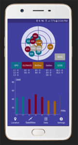
    The tablets have a dual-frequency GNSS module built in, which provides stand-alone sub-meter accuracy to centimeter-level accuracy with RTK from GPS, GLONASS and Galileo satellites.

    The tablets are compatible with existing survey and GIS software for mapping applications and provide an advanced workflow for data capture, accurate positioning and data transmitting.

    “We now have essentially created one-person survey crews because the DT Research tablets are so much easier to use than a tape measure and paper to accurately calculate and record measurements during complex construction projects,” Pucci said. “Using the tablets saves us an average of $2,000 for every survey-grade measurement job that does not require a full survey crew.”

    “In addition, the tablets have provided us with a contract verification system by having highly accurate digital-as-constructed measurements that are delivered immediately and stored forever, which saves the state time and money by avoiding independent re-measurement checks due to billing discrepancies at the end of a project,” added Pucci.

    The DT Research GNSS tablets can store up to 1 Terabyte of data for field data collecting. Users can avoid down time with a high-capacity hot-swappable battery pack, which delivers 60 or 90 watts for up to 15 hours of continuous mobile communications. The units include Long Range Class 1 Bluetooth, which powers wireless connectivity up to 1,000 feet and 4G mobile broadband.

    “The simplicity of how the DT Research tablets work is amazing,” Pucci said. “Unlike complex professional survey equipment, the DT Research tablets are a Windows-based mobile device with a user interface that is familiar to workers. In just two hours, I can easily train state workers with diverse skill sets to measure quantity, linear features and volumes for a variety of projects — and they are ready to go.”

    The tablets run on Microsoft Windows 7 Professional or Windows 10 IoT Enterprise and are high performance devices with an Intel 6th or 8th Generation Core i5 or i7 processor. The rugged tablet is designed for outdoor use with a brilliant LED-backlight, 800 nits sunlight-readable screen and capacitive touch.

    “We have found the DT Research tablets to be incredibility easy to manage and highly durable — we just turn them on and they work,” said Pucci. “In the three years that we have used the tablets, we have had very few technical support questions and they hold up well in different weather conditions. There isn’t a comparable product on the market at the price point.”

    The DT Research tablets are military-grade durable devices, yet lightweight, offering the versatility to be used in field-to-office settings. For use in harsh environments, the tablet is fully ruggedized to meet the highest durability standards with an IP65 rating, MIL-STD-810G for vibration and shock resistance and MIL-STD-461F for EMI and EMC tolerance.

    For use in a variety of environments, the tablets are complemented by many accessories including: external antennas, pole mount cradles, detachable keyboards, battery charging kits and digital pens.

  • Topcon upgrades MAGNET Collage for UAV and GIS data

    Photo: Topcon
    Photo: Topcon

    Upgrade to MAGNET Collage Web includes with new deliverable options.

    Topcon Positioning Group has upgraded its MAGNET Collage Web, a web-based service enabling the sharing and collaboration of UAV and scanning data sets.

    MAGNET Collage Web version 1.3 allow operators to work with more types of data with greater flexibility, including the ability to import BIM models, as well as CAD and GIS data.

    MAGNET Collage Web and MAGNET Collage desktop software meet the demands of a diverse user-group. The latest update is designed to address an increasing need from the vertical building construction market segment to work in a single-software environment with BIM, scanning and UAV datasets.

    “Now operators can view and publish BIM models, along with other data types, directly through the web browser to be sharable with more versatility,” said Alok Srivastava, director of product management. “MAGNET Collage Web can be used to overlay as-built laser scans and design data to visualize proposed changes and detect construction issues. The software supports OBJ, FBX and 3DS formats.”

    The upgrade to MAGNET Collage Web also includes new direct publishing functionality for CAD and GIS data files through the browser.

    “Operators can now overlay 3D point clouds and reality models with CAD and GIS design data, including support for DXF, SHP, KML, GML and GeoJSON formats,” said Srivastava.

    The upgrade to MAGNET Collage Web also introduces advanced sharing controls including the ability to fully customize layer visibility, appearance, window layout, feature selection and camera position.

    “The updated customization controls allow operators to share and present their projects exactly the way they mean to with a multitude of viewing options, allowing specific features to be highlighted as necessary,” said Srivastava.

    Additionally, MAGNET Collage Web can now be accessed through the Topcon “Blue Bar” that allows direct access to the service from any Topcon website. The universal account and application management toolbar is embedded at the top of Topcon web pages.

  • Canada awards Arctic surveillance contract to Space Flight Laboratory

    The Canadian Department of National Defence has awarded a $11.44 million contract to Space Flight Laboratory (SFL) at the University of Toronto Institute for Aerospace Studies (UTIAS) for the development of multipurpose microsatellites to support Arctic surveillance.

    Upon successful completion and testing of the prototype, two additional microsatellites will be built to create a small formation.

    The UTIAS SFL microsatellites, which are now being developed, will include multiple sensors on a constellation of microsatellites operating in close formation in low Earth orbit to allow for quick and timely detection and identification of surface or airborne targets.

    The concurrently obtained sensor observations are expected to improve the reliability of the detection and identification performance, which is not feasible when individual sensors are located on non-collaborating satellites.

    On behalf of Defence Minister Harjit S. Sajjan, member of Parliament for York Centre, Michael Levitt announced the contract on Feb 1 during a ceremony at U

    TIAS in Toronto. The contract was awarded through Public Services and Procurement Canada under the All Domain Situational Awareness (ADSA) Science & Technology (S&T) Program.

    “Space Flight Laboratory is honored to assist the Department of National Defence in developing next-generation satellite technology that could be used to monitor Canada’s vital Arctic region,” said SFL Director and Founder Robert E. Zee. “We are pleased that this investment acknowledges SFL as one of the world’s preeminent developers of advanced attitude control and formation-flying technologies for microsatellites.”

    Established in 1998 as a self-sustaining specialty lab at the University of Toronto Institute for Aerospace Studies (UTIAS), SFL has built more than 25 nano- and microsatellites with over 95 cumulative years of successful operation in orbit. SFL’s attitude-control technologies have also been applied successfully in several other microspace programs as well, including the 2016 GHGSat-D greenhouse gas emissions monitoring satellite and the 2013-2014 BRITE space astronomy constellation.

    As outlined in its defence policy Strong, Secure, Engaged, the Department of National Defence is investing in defence research and development to produce innovative solutions to surveillance challenges in Canada’s North, particularly in the priority areas of Arctic joint intelligence, surveillance and reconnaissance.

    Surveillance solutions support the Canadian government’s ability to exercise sovereignty in the North and provide a greater awareness of safety and security issues, as well as transportation and commercial activity in Canada’s Arctic. In addition, solutions achieved under the ADSA program will contribute to joint efforts between Canada and the United States to modernize elements of the North American Aerospace Defense Command (NORAD).

    The ADSA S&T Program leverages innovative science & technology expertise from other government departments, academia, industry and allies, to identify, assess and validate technologies in support of air and maritime surveillance, particularly in the North. Through a five-year investment of $133M through to 2020, the ADSA S&T Program is supporting the development of options for enhanced domain awareness of air, maritime surface and sub-surface approaches to Canada, in particular those in the Arctic.

  • NavVis now uses SLAM to remove point cloud artifacts

    The latest software release for the SLAM-based NavVis M6 Indoor Mobile Mapping System (IMMS) automatically detects and removes point cloud artifacts, including moving objects in static scenes, the company said.

    This image shows what an object looks like where the laser beam has hit an edge, before and after the algorithm has been applied. (Image: NavVis)
    This image shows what an object looks like where the laser beam has hit an edge, before and after the algorithm has been applied. (Image: NavVis)

    NavVis is a global provider of indoor spatial intelligence solutions. The latest IMMS release removes artifacts from point clouds during the post-processing of scan data.

    Fringe points and dynamic objects are two common types of point cloud artifacts that affect all 3D laser scanning devices. Fringe points arise when a laser beam hits the edge of an object as well as its background. This scattered beam ultimately appears as a “fringe” around the edge of the object in the point cloud.

    The second type of point cloud artifact results when dynamic objects, such as humans walking through a scan, are captured by the laser scanner and then appear as artifacts in the point cloud.

    A point cloud before and after the algorithm has been applied to a dynamic object. (Image: NavVis)
    A point cloud before and after the algorithm has been applied to a dynamic object. (Image: NavVis)

    According to the company, the NavVis M6 IMMS is a simultaneous localization and mapping (SLAM)-based system that uses laser scanners to capture a high volume of measurement points of an environment. As SLAM-based mobile mapping systems move through the environment while scanning it, objects are observed from multiple different angles and positions.

    With the latest software update, the algorithms applied during the post-processing of scan data use those multiple observations to detect whether measurement points actually exist in the physical space. If it is determined that the point does not exist and is instead resulting from the laser beam hitting an edge or an object moving through the space, this point is automatically removed.

    The result is a much cleaner, crisper point cloud that requires less clean up time in point cloud editing software and that is easier to use for applications such as BIM modeling, the company said.

    “We have been working hard to develop a very precise SLAM technology that significantly improves the quality of point clouds captured by a mobile device,” said Georg Schroth, NavVis co-founder and CTO. “As this latest software feature shows, SLAM offers a lot of potential for laser scanning and AEC professionals who are looking for technology that not only speeds up the capture of data but also delivers high quality point clouds. We see a lot of potential in this technology and look forward to sharing future innovations.”

  • Airbus and Hisdesat process first TerraSAR-X/PAZ radar interferogram

    Airbus Defence and Space and Hisdesat Servicios Estratégicos S.A. have generated the first joint TerraSAR-X/PAZ radar interferogram. This milestone demonstrates the missions’ capacity for cross-sensor interferometry, whose processing is among the most challenging.

    Interferograms are typically used to derive the topographic elevation and deformation of the Earth’s surface, and are created using at least two different images acquired at different date. This flattened cross-sensor-interferogram has been created from a mixed image pair with four days’ temporal separation acquired by TerraSAR-X and PAZ (StripMap scenes from Nov. 22-26, 2018). The area covers the oil and gas production site Burgan (Kuwait) and parts of the Persian Gulf. The oil field is the world largest sandstone oil field with the total surface area of about 1,000 km².

    As PAZ is positioned in the same orbit as TerraSAR-X and TanDEM-X and features exactly identical ground swaths and acquisition modes, they all three form a high-resolution SAR satellite constellation, jointly exploited by Hisdesat and Airbus. With the launch of PAZ, the observation repeat cycle has been divided by half, which improves the monitoring of fast ground deformation phenomena that can endanger lives and infrastructures.

    “This is a major step towards achieving the implementation of our TerraSAR-X/PAZ radar constellation,” said Hanjo Kahabka, head of production and radar constellation manager at Airbus. “The level of accuracy obtained with this interferogram is a guarantee for our customers to continue to rely on the high quality standard we have set with TerraSAR-X and TanDEM-X, but with an improved monitoring capacity,”

    “In Hisdesat we are very proud of reaching this milestone. Interferometry is one of the most technically demanding applications, and thanks to this successful joint exercise with Airbus we have not only demonstrated the top performance of our PAZ satellite but its full compatibility with TerraSAR-X and TanDEM-X,” said Miguel García Primo, CEO at Hisdesat. “Now operation in constellation can become a reality and we will be able to provide to our customers full set of images and services with the constellation.”

  • Durham public works uses Nearmap to manage massive city growth

    Nearmap high-resolution aerial image of Durham, North Carolina, photographed Jan. 15. (Photo: Nearmap)
    Nearmap high-resolution aerial image of Durham, North Carolina, photographed Jan. 15. (Photo: Nearmap)

    Location content provider Nearmap has partnered with the city of Durham, North Carolina, to help it manage infrastructure projects.

    The city’s Public Works Department uses Nearmap’s high-resolution imagery to aid in managing all infrastructure data for the city, including the city’s $16 million a year Stormwater Utility Fund.

    “Having access to imagery back to 2014, we’re able to go back in time during the thrust of development and monitor it forward,” said Edward Cherry, Durham’s GIS administrator. “With Nearmap, we’ve been able to update development processes and policies to support the revitalization of the downtown district as well as rapid city growth.”

    After using satellite imagery systems with low resolution and infrequent captures, Cherry and his staff of 14 GIS professionals determined the city needed superior mapping imagery.

    Captured every six months at a 2.8-inch ground sample distance, Nearmap supplies Durham with clear images that are up-to-date and accessible through web-based cloud servers, the company said.

    The result is better monitoring of pavement conditions; time savings and documentation of road repairs; more detailed maps of city riparian zones; and accurate and detailed customer billing.

  • Drones survey for geothermal energy in British Columbia

    Global UAV Technologies Ltd. has completed a drone-based geothermal energy exploration survey for Borealis GeoPower Inc. The survey used UAV-mounted geophysical and thermal imaging sensors over an area in northern British Columbia, Canada.

    Global UAV subsidiary Pioneer Aerial Surveys collaborated with Hummingbird Drones to collect and analyze high-resolution magnetometer and thermal data over the 2,200-hectare survey area.

    The survey was conducted using both day and night flight operations to maximize efficiency and data quality. The survey produced high-resolution deliverables on the geological and geothermal features of the survey area.

    The work was conducted at the Terrace, British Columbia, geothermal project, near the location of one of the world’s largest hot springs. Borealis is refining its reservoir model in advance of drilling in 2019.

  • Global GNSS launches survey application

    Global GNSS launches survey application

    Image: Global GNSS
    Image: Global GNSS

    Global GNSS, a subsidiary of Polosoft Technologies, has launched a new mobile application named GNSS Surveyor, which is designed for the geospatial industry.

    The application GNSS Surveyor provides location information and quality position data in real-time with sub-meter to centimeter accuracy. It needs to be connected to any external GNSS receiver via Bluetooth.

    Features of the application include:

    • A one-touch configured command to communicate directly with the GNSS Bluetooth device.
    • Location information and quality of the position data in real-time with centimeter accuracy.
    • GPS data such as position, height, satellites and velocity.
    • Constellation information for GPS, GLONASS, Galileo, BeiDou, QZSS and SBAS satellites in the orbit.
    • Direct IP feature for RTK corrections data.
    • DMS to DD conversion or vice versa.

    Real-time kinematic (RTK) correction data can be forwarded to a high-accuracy external device. The internal NTRIP client loads the RTCM data from the internet.

    With GNSS Surveyor, location information is collected as latitude and longitude, altitude, speed or pace, bearing and UTC time.

    GNSS precision includes global coverage, centimeter-level accuracy, fast time to first fix, multi-constellation and multi-band, and highest security, the company said.

    Navigation uses include ground robotics navigation, lane-level navigation, heavy machine navigation, industrial navigation and tracking and commercial UAV.

    GNSS Surveyor can be downloaded from the app store.

  • US National Data Infrastructure’s grade rises from C to B-

    COGO releases 2018 Report Card on the U.S. National Spatial Data Infrastructure (NSDI)

    The U.S. National Data Infrastructure (NSDI) is improving with broader expertise, according to an assessment by the Coalition of Geospatial Organizations (COGO).

    The NSDI’s grade rose from a C in the 2015 Report Card to a B- in the 2018 Report Card. The improved overall grades reflect a broadened base of experts and government organizations involved in the assessment, as well as an expanded set of assessment metrics, according to COGO.

    The report card uses a letter grading system to depict the status and condition of the nation’s geospatial infrastructure. The assessment measures NSDI’s ability to meet future geospatial data, based on address, cadastral, elevation, geodetic control, government units, hydrography, orthoimagery and transportation themes.

    Chart: COGO, from 2018 Report Card.
    Chart: COGO, from 2018 Report Card.

    Objectives of the NSDI include:

    • reducing the duplication of effort and expense among agencies,
    • ensuring that geographic data is more accessible to the public,
    • improving the quality of national data, and
    • establishing key partnerships within the geospatial field.


    “The new report card exemplifies that while progress has been made, federal, state, regional and local government agencies, tribal nations, and private and academic sectors need to continue to collaborate to complete this important work,” said NSGIC President Dan Ross. “NSGIC fully supports that collaboration and will continue to work with our members to support and move this initiative forward.”

    COGO member organizations represent leaders in the geospatial field and collectively represent more than 170,000 individual members. Member organizations aim to engage Congress, federal agencies and the FGDC to maintain successful practices and develop improvements and solutions related to the NSDI.

    The full 2018 Report Card on the U.S. National Spatial Data Infrastructure, along with the COGO executive summary, video webinar, and presentation slides can be found on the COGO website.

  • States ‘less than halfway’ in implementing GIS in elections

    United States’ election directors are interested, but “less than halfway,” in terms of implementing GIS to strengthen the nation’s electoral system

    The National States Geographic Information Council (NSGIC) has released its findings from its first survey of state election directors, seeking to determine the current status of the implementation of GIS in elections.

    A number of states have championed the use of this technology in recent years to strengthen the accuracy and reliability of their electoral systems. NSGIC’s Geo-Enabled Elections project was created to assist states and other election authorities in this process.

    According to the new Election Director Report, state election directors indicate knowledge and interest in GIS technology. However, the report’s findings also suggest that most states have a long way to go to fully utilize geospatial information in elections.

    Do you have access to GIS maps and shapefiles for each of your voting districts from a government source? (Image: NSGIC)
    Do you have access to GIS maps and shapefiles for each of your voting districts from a government source? (Image: NSGIC)

    Five out of six election directors interviewed stated that they are familiar with GIS and have access to a GIS expert. However, fewer than one in three could say with confidence that their voter registration system is capable of supporting GIS data.

    Moreover, when asked to assess their state’s degree of progress towards full integration of geospatial data in elections, the answer was four, on average, on a scale from 1 to 10, where 10 represented full GIS integration.

    “We’re very encouraged by the interest and enthusiasm we’ve encountered among election directors,” said Molly Schar, NSGIC executive director. “Few state election offices in the United States are fully GIS integrated. However, election directors, on the whole, are motivated to deploy the technology to increase accuracy and gain efficiencies in their election data management processes.”

    Why does using geospatial data offer a critical advantage to electoral systems? In short, it ensures that the right ballot is given to the right voter so that voters’ voices are heard in the right electoral contests. Recently, some well-publicized errors in voter placement have undermined the reliability of election results and may have hurt voter confidence.

    Additionally, replacing cumbersome voter lists and verbal definitions of voting districts with technology that allows election officials to view voters as pinpoints on a map — and voting district boundaries as geometrical shapes that surround those pinpoints — offers some very concrete advantages.

    The verification that voters have, in fact, been placed into the right voting district becomes much easier, as does quality control — both as part of a periodic review and after significant changes, such as the modification of voting district boundaries.

    Currently, many states use GIS technology for other matters, such as emergency response systems, land use, or utility management, and often have a Geographic Information Officer (GIO) within state government. Part of the Geo-Enabled Elections project’s mission is to promote a stronger dialogue between GIOs and election directors in state government.

    The project’s next steps for furthering the use of GIS in elections include six case studies from states already using GIS in elections, as well as five state-wide pilot studies among states working to expand their GIS integration, with the goal of delivering a set of best practices to support states wishing to start the process towards full GIS integration.

    The Geo-Enabled Elections project, phase one, runs from Oct. 1, 2017, to Sept. 30, 2019, with the aim to help strengthen electoral systems by supporting states in the adoption of GIS. Concretely, this means encouraging state governments to replace non-spatial ‘address file’ systems with election precinct and voter data in a GIS format, leveraging that format’s inherent visual and analytical advantages.

  • Hexagon presents GEOINT solutions at defense conference

    Hexagon’s Geospatial division, which offers high-performance geospatial solutions, showcased its defense solutions at DGI 2019, which took place Jan. 28-30 in London.

    DGI is Europe’s largest annual gathering dedicated to high-level discussions addressing the major challenges of the defense and government geospatial intelligence (GEOINT) community.

    The theme for this year’s conference is “Source, Analyze, Automate, Share,” and will provide senior defense leaders with opportunities to learn about new developments and innovations in geospatial data gathering and analysis.

    Whether for planning military operations, analyzing intelligence or determining responses to a natural disaster, Hexagon’s Geospatial division’s innovations shorten the time between data acquisition and real-time information delivery, driving mission success through actionable decision-making.

    Located at stand 8, Hexagon’s exhibition at DGI includes solutions from the Power Portfolio, M.App Portfolio and Luciad Portfolio, which improve data integration, access and delivery across the GEOINT enterprise. The following are some of the innovations that will be on display:

    • Machine Learning Processes Massive Amounts of Data: Understanding the situation on the ground starts with geospatial intelligence. Attendees will learn how ERDAS IMAGINE’s machine learning algorithms can be trained to process massive amounts of data, taking the load off analysts and freeing them up to do the work that humans do best.
    • M.App X: Rapidly Exploit Imagery: This cloud-based exploitation for defense and intelligence enables System Integrators to provide tools for the exploitation of imagery and the creation of intelligence and reports for their defense customers.
    • Command and Control: Providing true situational awareness in action, Luciad offers 2D and 3D integration of all data into one visualization tool, including full support for symbols and tactical graphics of the latest military symbology standards.

    “With the traditional battlefield expanding beyond land, sea, and air to the electronic, cyber, and social media arenas, today’s global defense and intelligence agencies operate in high-stakes environments where mission success comes down to accessing, analyzing, and sharing real-time visualization data,” said Mladen Stojic, Hexagon’s Geospatial Division president. “We look forward to showcasing our cutting-edge data analytics and visualization solutions that enable success in today’s multi-domain frontier at DGI 2019.”

    Hexagon Geospatial’s Director, Defense Sector, Tony Wheeler will also give a presentation on “A Tiered Approach to Analysis — Enabling the COP User,” on Tuesday, Jan. 29, from 2 to 2:20 p.m. The session will explore how technology can enable military staff to better exploit information — creating a new tier of analytical capability to augment that of dedicated intelligence organizations.

  • Esri ArcGIS Hub helps government agencies meet open data law requirements

    Logo: Esri ArcGIS HubEsri’s ArcGIS Hub is helping government agencies more easily and efficiently comply with new policies outlined in the Open, Public, Electronic and Necessary (OPEN) Government Data Act, Esri said.

    The OPEN Government Data Act sets a presumption that all government information should be open data by default — machine readable and freely reusable.

    According to Esri, federal agencies using the ArcGIS Hub can share data in open formats with only a few clicks and feed those data catalogs directly to data.gov, the government-wide website supported in the bill. In addition, apps and dashboards can help responders identify vulnerable populations areas, locate resources like shelters and hospitals, and visualize where and when routes to these resources are accessible in real time.

    The ArcGIS Hub online portals also enable government agencies to direct their open data to deepen citizen engagement with apps, data, events and collaboration focused on specific civic initiatives. According to Esri, ArcGIS Hub lets citizens, businesses, academic institutions and nongovernmental organizations take advantage of their governments’ spatial analytics capabilities to collaborate and turn data-driven goals into policy.

    “When authoritative data is unencumbered and interoperable, it enables effective and efficient government programs that save lives and money,” said Jill Saligoe-Simmel, Esri product manager for spatial data infrastructure. “Esri supports the OPEN Government Data Act — combined with the recently passed Geospatial Data Act — as an essential component to modern spatial data infrastructures.”