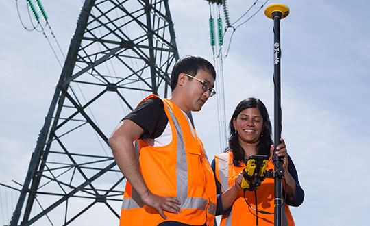
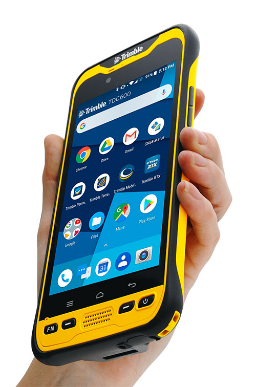
Trimble has introduced the TDC600 handheld, an ultra-rugged, all-in-one smartphone and GNSS data collector for geographic information system (GIS) and field inspection applications.
The next-generation smartphone data collector runs on an Android 8.0 operating system. It has a bright sunlight-readable 6-inch display, 2.2-GHz processor, 4-GB memory and an enhanced capacity all-day battery.
More powerful and with a longer lasting battery than its predecessor, the TDC600 handheld supports the Trimble Catalyst GNSS positioning service that delivers subscription-based accuracy on demand for Android devices.
In addition, the TDC600 can be used with external receivers such as the Trimble R2 and R1 GNSS receivers, and also features a built-in GNSS receiver that supports GPS, GLONASS and BeiDou constellations plus satellite-based augmentation system (SBAS) capabilities for real-time positioning.
The TDC600 is built for GIS users in organizations across a variety of industries —environmental management, utilities and government agencies. With Wi-Fi, Bluetooth 4.1 and 4G LTE cellular connectivity that supports data and voice calls, field workers are able to use the TDC600 as they would any consumer smartphone, communicating between the field and office, sending emails and texting.
Featuring a slim, lightweight and ergonomic pocket-size form factor, the TDC600 fits in a user’s hand with a fitted strap providing extra security. Constructed to meet military (MIL-STD-810G) specifications, the durable design absorbs drops and shocks, and works in harsh weather conditions, without the need for a protective case.
The TDC600 integrates seamlessly with Trimble’s data collection applications —Trimble TerraFlex] software and Trimble Penmap for Android software — as well as third-party apps such as Esri Collector for ArcGIS.
With its Google Mobile Services certification, users can run Google core applications and access apps on the Google Play Store to personalize their device.
“The global mobile workforce is growing, and field personnel are constantly tasked with capturing and computing large amounts of data in more places with greater accuracy, requiring powerful and reliable data collection methods,” said Rachel Blair-Winkler, business area manager for Trimble Mapping & GIS.
“A professional turnkey solution such as the TDC600 handheld running Trimble data collection apps paired with the Trimble Catalyst service fulfills this requirement,” Blair-Winkler said. “Our customers now have a powerful, comprehensive and cost-effective entry-level system to collect and retrieve highly accurate GIS data virtually anywhere in the world.”
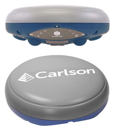
Carlson Software has introduced a new four-constellation, three-frequency surveying receiver. The Carlson NR3 network rover weighs just under two pounds, but delivers highly reliable GNSS real-time kinematic (RTK) for land surveying, geospatial information systems (GIS) and other data-collection uses.
Carlson Software President and Founder Bruce Carlson introduced the Carlson NR3 network rover at the company’s Grow With Us User Conference 2019.
Able to be used as a base or rover, the NR3 uses all four constellations — GPS, GLONASS, BeiDou and Galileo — and provides triple-frequency tracking on GPS, GlONASS and Galileo, the company said.
Incorporating multipath and ionospheric detection, the NR3 maintains accuracy and continued operation despite shocks, vibration or other interference.
According to the company, the NR3 is easy to mount and balance as it utilizes the optional Hybrid+ in Carlson SurvCE/PC that enables simultaneous interaction with GNSS and a robotic total station, the company said.
”The NR3 is Carlson’s answer for a lightweight – just 1.8 lbs. – network rover that can also be used in a base rover setup with Carlson’s Listen-Listen service,” said Butch Herter, Carlson’s director of Hardware Development. The Listen-Listen service allows base/rover operations via cellular modem for better correction transmission ranges compared to traditional terrestrial UHF radios.
“It has hot swappable batteries and four come with the system that give it over a 20-hour runtime,” Herter added. “With the dual internal cell modem antennas, it maintains cell signal where others may not. When paired up with the Carlson CR2+ robot, it is the ideal companion receiver to use with the new SurvCE hybrid surveying system.”
Produced by Septentrio with Carlson specifications, the Carlson NR3 has an integrated 4G LTE cellular modem, plus Wi-Fi and Bluetooth for modern wireless capabilities and is made to perform exceptionally in locations with bad visibility or interference.
The new senseFly Solar 360 UAV is designed to enable the automated and efficient inspection of solar farms.
Photo: SenseFly
SenseFly has introduced its senseFly Solar 360. Created in collaboration with software company Raptor Maps, the offering is an efficient thermal drone solution that enables the automatic assessment of solar plant performance at a sub-module level, the companies said.
Created by combining eBee X fixed-wing drone technology, senseFly’s Duet T thermal mapping camera and Raptor Maps’ software, senseFly Solar 360 is a fast and fully automated drone. It is easily integrated into solar management workflows without requiring either drone piloting skills or the manual analysis of aerial solar farm data.
“At senseFly we are continually looking across the industry to identify new commercial partners with whom we can bring to market what our customers need, which is vertically-focused end-to-end solutions,” said Gilles Labossière, CEO of senseFly.
“With Raptor Maps, we are collaborating with a true solar industry pioneer,” Labossière said. “Their software takes the guesswork out of solar farm inspection and, crucially, speeds up this process — from days down to hours. This efficiency, combined with the eBee X’s large coverage and reliability, ensures that farm owners and operators — or the drone service providers they employ — can inspect utility-scale solar farms more quickly, easily, and accurately than ever before.”
“Solar power is the largest source of new energy generation in the world,” said Nikhil Vadhavkar, CEO of Raptor Maps. “This rapid growth has fueled demand for industry-specific solutions to allow solar customers to scale. Our enterprise-grade software has been deployed across six continents and 25 million solar panels to increase power production and reduce risk and maintenance cost across solar portfolios. We are proud to collaborate with senseFly, the industry leaders in commercial fixed-wing drones, to increase access to Raptor Maps while providing a comprehensive, end-to-end solution that scales with the solar industry.”
Blue Marble Geographics has released a new version of the Global Mapper software development kit (SDK), providing software engineers with the means to embed the latest geospatial technology into their custom applications.
Blue Marble’s GIS software has been used by GIS professionals for 25 years. Users come from all industries including software, oil and gas, mining, civil engineering, surveying and technology companies, as well as government departments and academic institutions.
Global Mapper’s GIS application is capable of displaying, converting and analyzing virtually any type of geospatial data. The Global Mapper SDK and accompanying Lidar Module SDK provide software developers with a toolkit for accessing much of this functionality from within an existing or custom-built application.
The SDK also enables the creation of custom toolbars and extensions to enhance the data processing and analysis functionality of the standard version of Global Mapper. This capability allows in-house developers to create a unique version of the application to meet their specific needs or for software companies to build custom products for commercial distribution.
Highlights of the latest version of the SDK include:
A new function to allow querying of elevation from a specific list of elevation layers
Significant speed improvements when working with vector data with attributes
Faster viewshed calculation on computers with multiple cores
Support for downloading vector features from Esri RESTful data sources
S-52 point symbols for S-57 and S-63 marine chart files
Updated SHIFT_LAYER script command to support shifting in the Z (elevation) direction.
Support for several new formats including, OpenFlight and HEC-RAS raster and vector files
The supplementary Lidar Module SDK now offers:
The ability to select points based on their proximity to other lidar points and/or line features
A new option to update the return number/count when deleting multi-return points
“Global Mapper’s reputation as a powerful geospatial data processing and analysis application is well known throughout the world and software engineers are increasingly integrating these tools into a wide variety of development projects,” said Patrick Cunningham, Blue Marble president. “The Global Mapper SDK is unrivaled in its ease of deployment, data format support, affordability, and in its adaptability, allowing it to meet the ever-changing needs of today’s geospatial software development sector.”
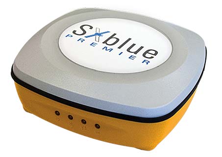
Geneq Inc., a manufacturer and provider of GNSS receivers and positioning solutions to GIS professionals and surveyors, has launched its newly designed website. The website features new functionalities, better product viewing options, and improved product support options.
The completely redesigned website to support the company’s product and service improvement program, the company said. The new website will be regularly updated with news on SXblue products, product support, software updates, events and social media feeds. The company welcomes feedback from clients, distributors and partners.
Geneq Inc. has been developing and manufacturing professional GNSS receivers and software products for 15 years. Its SXblue brand has been sold around the world.
Raytheon Company’s advanced high-power microwave and mobile high-energy laser systems engaged and defeated multiple unmanned aerial system targets during a U.S. Air Force demonstration. The mature HPM and HEL technologies offer an affordable solution to the growing UAS threat, the company said.
Raytheon made the announcement at AUVSI Xponential, which took place April 29-May 2 in Chicago.
Raytheon’s mobile high energy laser looks out into a wide-open sky. The company’s advanced high-power microwave and high-energy laser engaged and defeated dozens of unmanned aerial system targets in a recent U.S. Air Force demonstration.
The HEL system, paired with Raytheon’s Multi-Spectral Targeting System, uses invisible beams of light to defeat hostile UASs. Mounted on a Polaris MRZR all-terrain vehicle, the system detects, identifies, tracks and engages drones.
“Countering the drone threat requires diverse solutions,” said Stefan Baur, Raytheon Electronic Warfare Systems vice president. “HEL and HPM give frontline operators options for protecting critical infrastructure, convoys and personnel.”
Raytheon’s HPM uses microwave energy to disrupt drone guidance systems. High-power microwave operators can focus the beam to target and instantly defeat drone swarms. With a consistent power supply, an HPM system can provide virtually unlimited protection.
“After decades of research and investment, we believe these advanced directed energy applications will soon be ready for the battlefield to help protect people, assets and infrastructure,” said Thomas Bussing, Raytheon Advanced Missile Systems vice president.
Raytheon’s HEL and HPM were the only directed energy systems that participated in this Air Force experimentation demonstration. The event expanded on previous directed energy demonstrations such as a U.S. Army directed energy exercise held in 2017.
According to Attollo Engineering, its WASP series of rangefinders are designed to measure ranges at a rate of up to 10,000 points per second. (Photo: Attollo Engineering)
Attollo Engineering, a privately-held company focused on the design and manufacturing of laser sensing and infrared imaging devices, launched the WASP-200 LRF, a laser rangefinder with varied configurations. According to the company, its WASP series of rangefinders are designed to measure ranges at a rate of up to 10,000 points per second with remarkable accuracy and precision in a tiny package.
The WASP-200 LRF can be used for precision agriculture applications and as a proximity-to-ground sensor onboard small or large unmanned aerial vehicles. It has 1-centimeter resolution and 10-centimeter accuracy, the company added. In addition, the laser rangefinder is compatible with the Collins Aerospace Piccolo (CAN Bus and RS-232) and Pixhawk drivers.
The WASP series of rangefinders also feature single-shot laser ranging for fast scanning and moving platforms; programmable burst mode averaging; an IP 67 option; connector options, including pigtails; durable molded ABS plastic housing; and integrated back or front mounting.
According to Attollo Engineering, the rangefinders are suitable for a number of applications, including robotics and drone, sense and avoid, industrial automation, height and distance measurements, and maritime operations.
Attollo Engineering will be showcasing the WASP-200 LRF at booth 2604 at AUVSI’s Xponential 2019 in Chicago.
Household size distributions are critical inputs to many business analyses, but may not be correctly derived from U.S. Census data, according to Caliper.
The Census counts people at their geographic locations, and when several unrelated people live at the same address, they are reported as one household with a number of residents.
A confusing array of data is reported. In both the Census SF1 2010 file and in 2017 ACS, the following tabulations are provided down to the Census tract level:
People in Family Households
2 person Family Households
3 person Family Households
4 person Family Households
5 person Family Households
6 person Family Households
7+ person Family Households
Non-relatives in Family Households
Unmarried Partners (including same-sex couples) in Family Households
People in Non-Family Households
Unmarried Partners (including same-sex couples) in Non-Family Households
There is also extensive information on people residing in group quarters in the 2010 Census, which has the tabulations below:
People in Group Quarters: College
People in Group Quarters: Military
People in Group Quarters: Navy Ships
People in Group Quarters: Other
People in Group Quarters: Homeless
People in Group Quarters: Group Homes
People in Group Quarters: Residential Treatment
People in Group Quarters: Merchant Ships
People in Group Quarters: Workers’ Group Living Quarters
People in Group Quarters: Other Other
People in Group Quarters: Institutionalized
Using this information, Maptitude 2019 includes a corrected data set of household size distributions for Census Tracts and Block Groups to account for the under-representation of one-person households in the Census data.
Census tracts with Caliper derived households. (Image: Caliper)Census tracts with Census household count. (Image: Caliper)
SimActive Inc., a developer of photogrammetry software, announced that Correlator3D is being used for mapping projects in Brittany, France, by Altimedias.
An eBee X equipped with senseFly S.O.D.A. 3D camera is flown along the shoreline to produce high-resolution true orthomosaics and 3D models.
“The quality of outputs from Correlator3D is exceptional and the mosaic renders the vivid colours of the Pink Granite Coast,” said Didier Wasselin, COO at Altimedias, which specializes in drone data collection and processing. “Such results are very useful for heritage conservation and decision making by local authorities.”
“The combination of SimActive software and senseFly eBee Plus X is an ideal combination, due to the accurate RTK/PPK and optimized aerial triangulation,” said Francois Gervaix, technical advisor at SimActive. “The S.O.D.A. oblique imagery leads to outstanding 3D textured models.”
Administered by the National Geospatial-Intelligence Agency (NGA), the mission of IGAPP is to streamline the deployment of commercial mobile apps to government personnel by bridging the gap between traditional government contracting procedures and non-traditional businesses.
Blue Marble’s GIS software is used by hundreds of thousands of mapping professionals throughout the world who need affordable, user-friendly, yet powerful GIS solutions. Users come from a wide range of industries including software, oil and gas, mining, civil engineering, surveying and technology companies, as well as government departments and academic institutions.
Available on both iOS and Android platforms, Global Mapper Mobile enables remote access to mission-critical geospatial datasets in an easy-to-use application. Used in conjunction with the desktop version of the software, Global Mapper Mobile supports hundreds of GIS data formats — both raster and vector — and offers simple, form-based field data collection and geotagged photo capture.
To address the specific needs of the geospatial intelligence (GEOINT) community, the IGAPP version of Global Mapper Mobile includes streaming access to online data services and the ability to store downloaded tiles for remote offline use.
“IGAPP provides mission-relevant, cyber secure mobile apps to warfighters, aviators, mariners and first-responders,” according to John Holcomb, IGAPP program manager at Engility, the NGS’s broker for putting commercial applications into the GEOINT App Store. “The program provides commercial vendors with a rapid, cost effective, path to sell their products. We are thrilled to add the Global Mapper Mobile the store and look forward to getting into the hands of DoD users.”
“Over the years, the GEOINT community has strongly supported our products and has provided valuable feedback that has helped ensure the functionality of our software is addressing the needs of geo-intelligence,” stated Patrick Cunningham, Blue Marble President. “We are delighted that Global Mapper Mobile is now available through IGAPP and that more and more field personnel now have easy access to this valuable app.”
The Trimble TDC150 handheld is a new field computer designed for GIS data collection, inspection and management activities.
The TDC150 provides users with a rugged device that has the flexibility of a handheld, a modern interface with open Android operating system, and scalable high-accuracy positioning for professional field workflows.
The TDC150 provides advanced GNSS capabilities in a durable, ergonomic and lightweight form factor. With a built-in GNSS antenna, the TDC150 is a scalable solution that allows customers to choose their desired accuracy. Easy-to-use and carry in the field, it features a bright 5.3-inch sunlight-readable touch screen and an all-day battery for continuous work on the jobsite, the company said.
The handheld comes with Google Mobile Services certification to run Google core applications and access thousands of apps on the Google Play Store. Professional GIS field applications, including Trimble TerraFlex software — a cloud-based solution that enables users to easily collect, manage and edit their geospatial feature data — are supported, as well as Trimble Penmap for Android software and Esri’s Collector for ArcGIS mobile app.
A new innovative TerraFlex workflow uses the TDC150’s onboard rear-facing camera to capture features. This visual aid shows users when the camera and receiver are aligned over features, enabling horizontal centimeter accuracy when holding the device.
“The mapping and GIS industry, including utility companies, local government, and environmental management agencies, look to Trimble for continued innovation,” said Rachel Blair-Winkler, business area manager for Trimble Mapping & GIS solutions. “Adding the ability to get the level of horizontal accuracy required in a handheld configuration without the need for an external pole and antenna, and the new camera-based data logging workflow, gives our customers the flexibility to accomplish more while out in the field.”
Written by William Tewelow, GISP and Co-written by Jon Gustafson, GISP
Significant focus on infrastructure asset delivery and lifecycle must become a priority so that architects, engineers and construction (AEC) can leverage BIM systems for design, construction and management solutions.
Innovations in BIM applied to infrastructure construction projects will enable “smart” solutions. This article explores BIM for infrastructure insights and brings attention to closing the BIM divide between the vertical (buildings) and the horizontal (linear) infrastructure industries, such as roads, bridges and pipelines.
For smart systems to be applied to infrastructure, CAD needs to evolve to the point where those multi-dimensional models can integrate with geographic information systems (GIS). The larger the project, the more necessary it is for a seamless data transition from the local engineering scale to the municipal, regional or national reference systems.
Autodesk defines building information modeling (BIM) as an intelligent 3D model-based process that gives architecture, engineering and construction (AEC) professionals the insight and tools to more efficiently plan, design, construct and manage buildings and infrastructure.
It is like a GIS in many respects, but applied locally to a structure. It is able to do many common geospatial calculations. It is still an evolving technology, but it is clear that soon it will do for AEC and facilities management what GIS did for surveying and cartography.
A smart move
Systems have evolved augmenting our abilities with built-in applications that can integrate connected data and systems to enhance and extend our capabilities. These systems are termed smart, which has become the newest marketing buzzword.
Everything is getting the smart label. Along with the label is an expectation that the lines between the physical and the digital worlds are blurring as we slip ever nearer the veil wherein we will simultaneously co-exist in both worlds.
Smart also infers it is connected to the digital cloud, that seemingly infinite expanse measured by petaflops, into which artificial intelligent algorithms augment everything with contextually aware information overlaid atop our own experience of the world.
Of course, this view has its pitfalls and cautionary tales, and every step we take into the future we lose some connection with the past. For example, everyone can use a calculator, but are times tables even taught anymore? Automation leads to complacency.
When CAD was unimaginable
Let’s take a brief look backward. The year was 1978, my second year of high school. I took drafting class as an elective and would end up doing so for the rest of the time I was in high school, accumulating enough credit hours to graduate with a vocational degree equivalent in architectural design. Those were the days of drafting tables, slide rules, French curves, triangles, keen eyes and steady hands.
The last year of school, there was talk of something called computer-aided drafting or design (CAD) that would make all we were doing obsolete. It seemed impossible at the time. Especially after I took a brand-new summer course called computer programming. Computers were large, heavy, clunky things that had limited abilities. They were basically responsive text machines. Program something in BASIC, save it, and then from the DOS command window, run it over and over again.
I remember reams and reams of green and white paper two foot wide fed by geared teeth, and pages of pages of our coded programs that we would have to pour over looking for the mistake in the line of code. And, this long and lengthy code was merely to archive and sort information or make the computer draw a cat or some other object using “X”.
We would all stand around the dot matrix printer as line by line the image took shape on the printed page. There was that wondrous feeling of success creating something having first conceived it in the mind then, like digital-smiths, forging it in a non-physical space and holding it in our hands. But I could not understand how that blinking white cursor on a black screen could ever replace the rich colors and smoothed lines of the beautiful architectural drawings I had spent years learning.
I felt confident the stories of our trade being overtaken by CAD were greatly exaggerated. That lesson taught me that change is inevitable and far beyond our rational ability to comprehend what is possible based on our current understanding. I watched as computer-aided design did take over, giving engineering and architectural drawings multidimensional context.
Horizontal lags behind
Now, let’s jump back into the present. The horizontal industry is behind the vertical industry with respect to project management deliverables. In part, this disparity will be aided by the Geospatial Data Act which was passed into law on Oct. 5, 2018.
The linear model is approximately 10 years behind the vertical model, especially for above-ground assets and facilities. However, recent technology advancements — augmented reality (AR), unmanned aircraft systems (UAS), indoor lidar and modeling software — and influential advocacy initiatives (such as public agency innovation programs like smart cities) are starting to enable digitally integrated management of asset information more holistically. Indeed, there is urgency for these linear systems to be adequately captured.
The Feb. 6 explosion from a ruptured gas line in San Francisco showed the dangers of not having an adequate map of the subsurface infrastructure. Fortunately, no one was injured, but damage from subsurface infrastructures can be deadly like the San Bruno disaster in 2010.
Gas line explosion damage in San Bruno, California. (Image: U.S. Department of Transportation)
The “Call Before You Dig” law was enacted for this very reason. At the very least, problems with linear infrastructure can negatively impact a city’s quality of life and budget such as a water main break or a broken sewer line.
Looking ahead 5-10 years, horizontal infrastructure designers and installation companies will use 3D modeling tools as standard practice in an open data sharing environment allowing other networks to access the information and add it to their own projects.
Imagine a county’s 811 system, the universal number to call before you dig, and instead of calling, it is an app on a users’ phone. A requester submits a short form and receives a text when the application is approved, usually within minutes, and is then able to view an augmented reality overlay of the subsurface infrastructure in the vicinity beneath the ground where the requester’s project is taking place.
This approach has economic benefits, providing faster turn-around times, increasing citizen engagement and improving the safety of communities. Over time, it is a “collect once and use many times” system — it will reduce demand on city staff and billable hours, saving cities money.
The same technology is also available for construction projects, providing schematics to see pipes, ducts and wires in walls, floors and ceilings. This is not science fiction. Existing condition data is already being collected in 3D, so it is logical to anticipate engineering design will be prompted to support ongoing 3D collection efforts and begin doing work in 3D.
Using BIM from the outset of a project builds this into a system that can be accessed later. However, the use of these advanced augmented reality technologies are limited to certain geographic areas with enough funding and technical capabilities. This is primarily in large urban areas, new growth areas, and redeveloping areas of a city; however, large infrastructure projects such as pipelines, railroads, highways, bridges and hyperloops will have to develop high-resolution models that will capture some of the surrounding areas and benefit all communities along the routes helping to bridge the disparity of the BIM divide.
In time, as costs come down and the technology improves and becomes easier to use, all communities will benefit from and incorporate this emerging technology.
Photo: Krauchanka Henadz/Shutterstock.com
BIM for intelligent infrastructure: sensors and structures
Critical to BIM for smart infrastructure is the fusion of sensors, data and infrastructure. Sensors will be embedded within and affixed to physical assets for the purposes of collecting data and self-monitoring for machine learning, maintenance and repair. Networking internet-enabled devices that actively and passively sense is at the core of the internet of things (IoT). Data from these IoT devices will improve physical asset management, creating unique opportunities for agencies, especially when considering how machine learning can discern patterns in data to detect anomalies, and improve safety such as self-aware systems that can heat road surfaces when precipitation is detected in below-freezing temperatures.
The digitizing of the physical world will take place with greater demand for higher resolution capabilities. Physical structures will require an exact computerized replica, referred to as a Digital Twin. An effort is underway by the Open AR Cloud Organization (OARC) to create an open standard for this digital twin of the world, so that applications and innovation will not be hampered by proprietary systems.
Yohan Baillot, CEO of ARcortex and founder of the Open AR Cloud, explained if there is no open standard, something developed in one system may not align with applications viewed in another system. This could be costly and disastrous for transportation and construction projects. Point in case would be the above example of Call Before You Dig,if a gas pipeline is incorrectly depicted and a work crew ruptured it.
This Digital Twin is both a high-resolution GIS and a basemap for both vertical and linear BIMs to connect into. Knowing the location of subsurface assets is foundational to the increasing investment into smart cities, which is forecast to become a $3.5 trillion industry within the next seven years.
David Rouse (2017) defines smart cities as cities that use information and communication technologies to increase operational efficiency, share information with the public, and improve both the quality of government services and public well-being. Using smart devices, communication among the devices and with the entities managing those devices provide deeper insight on device behavior and the ability to develop algorithms to change device parameters using other sensors in close proximity.
All of this data can be used to optimize asset performance over time. In the U.S., San Francisco, New York, Chicago, Los Angeles, Boston and San Jose all have active smart city projects advancing connectivity (Nominet 2018).
Intelligent infrastructure augments users’ abilities by the multiplicity of sensor arrays (self-monitoring devices, RFID, Wi-Fi, GPS receivers, cameras, etc.) communicating with decision-support systems as well as other sensors — the internet of things (IoT). For instance, high mast cameras combined with artificial intelligence algorithms for object recognition deployed along a stretch of highway allows stakeholders to extract important insights of that physical asset (such as surface condition, traffic flows and vehicle counts) and provide that information in real time to emergency response crews, police and security, maintenance vehicles, network-connected vehicles and others.
Digital integrations
Intelligent transportation systems are entering the next generation enabling vehicle-to-infrastructure (V2I) interactions. The U.S. Department of Transportation (2018) website states,
V2I technologies capture vehicle-generated traffic data, wirelessly providing information such as advisories from the infrastructure to the vehicle that inform the driver of safety, mobility or environment-related conditions. State and local agencies are likely to install V2I infrastructure alongside or integrated with existing ITS equipment.
The Open Connectivity Foundation (OCF) endeavors to provide open standards and certification to make connectivity easier, more reliable and more secure by bridging IoT ecosystems.
Specifically, OCF specifications can be used to develop vehicle data model translators that enable remote fleet management for autonomous vehicles, OBD device interactions (vehicle performance monitoring) and crowdsourcing of data models for continued development (Open Connectivity Foundation 2018). Currently, many transit agencies are seeing growth in equipping rolling stock with IoT devices including GPS, Wi-Fi and traffic light preemption, which improves fleet optimization and data accessibility, and enables better congestion management as well as increased system performance (American Public Transportation Association 2018).
Crowdsourcing data from web-based and mobile applications is a popular public engagement mechanism. Crowdsourcing at its most basic level is the aggregation of (big) data from a large group of people. From an asset management perspective, leveraging the general public’s direct and indirect collection of data brings deep insight into asset performance and condition.
The data collected provides the ability to better plan transportation systems with demand modeling, predictive analytics, event response times to identify those impacted and determine where additional capacity is needed, and to provide personalized services (such as through email and text) including weather-related events impacting the commute.
Applications such as Waze empowered the public with the ability to report hazards, construction zones and other concerns on the road and shoulder that DOTs can use to dispatch resources to address the situation/issues quickly. Furthermore, Alavi and Buttlar (2019) identified sensing capabilities of smartphones and their crowdsourcing power for monitoring several distinct civil infrastructure systems such as pavement.
Conclusion
In summary, BIM for infrastructure overlaying a robust GIS plays a critical role for supporting advanced technologies for integrating dynamic IoT and crowdsourced data.
Infrastructure asset owners are encouraged to recognize the importance of BIM-oriented policy and practices and invest in required initiatives that make incremental progress towards a smart infrastructure vision.
BIM is the foundation of intelligent infrastructure and defines the backbone of smart cities.
References
Alavi, Amir H., and William G. Buttlar. 2019. “An overview of smartphone technology for citizen-centered, real-time and scalable civil infrastructure monitoring.” Future Generation Computer Systems 93: 651-672. https://doi.org/10.1016/j.future.2018.10.059.
Jon Gustafson, PS, CFedS, PMP, GISP is a management consultant with one of the world’s largest professional services companies, WSP (https://www.wsp.com). He is an accomplished business-oriented technical professional consistently recognized as an industry leader in multi-jurisdictional land surveying practice, geospatial policy development and program/project management. He helps his clients address infrastructure technology deployment challenges by developing effective recommendations/guidelines focused on advancing civil integrated management practices and innovations. Some recent projects include developing data governance strategies for major infrastructure programs, conducting applied research on digital project delivery initiatives, advancing UAS integration, and formulating geospatial technology strategies for a public agency.