Technology multinational GMV has launched Covclear, a mobile app to ensure a safer and more efficient return to work after the COVID-19 lockdown.
The application helps to make sure offices will be a safe workplace while minimizing the risk posed to the health of employees or other persons who are working in open workplaces in an environment of maximum safety and protection.
The app is collaborative and relies on a principle of co-responsibility between the company and its employees to protect their own health and the health of their relatives and workmates.
Covclear integrates all the following in a single platform: a daily medical health check of all employees; recording of trips to restricted sites; contact tracing within the firm; control of office access by means of temperature readings; quarantine management; and control of site occupancy. It also publishes the company’s healthcare crisis rules.
First and foremost, it offers a self-check prepared by clinicians to assess the state of people and pinpoint any contagion risk before they commute to work. On the basis of employees’ daily responses, the app determines their risk level on their own phone, generating a workplace accessing QR color code.
A red code would trigger automatic three-day contract tracing, giving all these contacts instant and anonymous warning so they can act accordingly. All this is conducive to the ongoing safety of all work colleagues.
Covclear also allows for management of site occupancy, assigning days of on-site working to employees and thereby ensuring maintenance of optimum occupancy levels in places with a large number of workstations.
The app developed by GMV has been designed to protect information at source, thereby guaranteeing data-protection compliance at all times. The company will have access only to the QR code color for carrying out the corresponding access control and to gain an overview of the company’s state of health.
Covclear, which is already successfully up and running in some company offices, springs from the company’s own safety needs. It has been set up in only a few weeks thanks to the company’s wealth of expertise in the development of technology and mobile apps.
At the same time, and mindful that it could be useful for third parties, GMV is also making this app available to its clients and suppliers and to any other firm that might be in need of such safe going-back-to-work services.
Covclear includes four applications: iOS and Android user apps, an Android personnel access control app, and an administration web tool for the company. The data is kept in totally dependable, GDPR-compliant cloud servers.
The F-110 frigate being developed for the Spanish Navy. (Artist’s concept: Spanish Ministry of Defense)
The technology multinational GMV has signed a contract with Spanish corporation Navantia to develop and supply its SENDA navigation system for the future F-110 frigates.
The F-110 frigates represent a technological leap forward in platform systems and its combat system, incorporating Industry 4.0 technologies to improve lifecycle-long system management.
The various F-110 systems call for a continuous, precise, and trustworthy positioning, speed and attitude source. With this purpose in mind, SENDA incorporates multi-constellation (GPS and Galileo) satellite navigation technology compatible with both civil and military signals, plus differential GNSS corrections. It combines its GNSS navigation data with data received from external sensors, such as inertial navigation systems (INS) and pitometer logs. It includes state-of-the-art algorithms to provide robust navigation in contested GNSS scenarios.
SENDA also includes a timing server that generates highly precise and stable timing signals, allowing the ship’s systems to synchronize with GPS time. SENDA guarantees timing-reference stability and negligible drift, even during prolonged periods of GPS downtime.
SENDA is a redundant system with two complete functional subsystems working in active-active configuration, together with redundant GNSS signal distribution. Both systems, monitored in real time, exchange information to provide the overall system with the best possible solution.
GMV has experience in aeronautics, land and naval sectors with platforms such as the Atlante tactical long-endurance UAV, the 8×8 Dragon ground vehicle and now the F-110 frigates.
GMV worked with the Spanish Ministry of Defense MoD to develop a system prototype during the F-110 definition phase. The future F-110 frigates will replace the current Santa María class frigates starting in 2026.
The technology multinational GMV has won a contract under the Spanish Ministry of Defense’s (MoD’s) RAPAZ program for the supply of four Class I Seeker RPASs to be integrated into the intelligence units of the Paratrooper Brigade and the Tercio de Armada de Infantería de Marina (Marine Infantry Protection Force).
The contract will provide the armed forces with the most advanced version of the unmanned aircraft Seeker.
The UAS Seeker is an autonomous, rapid-deployment system developed by Aurea Avionics and supplied by GMV. It provides intelligence, surveillance and reconnaissance capabilities over a 15-kilometer range with a 90-minute endurance and a weight of 3.5 kg.
The aircraft will strengthen the intelligence, surveillance and reconnaissance capabilities of Spanish troops, ensuring better operational capability and tactical superiority.
Seeker constitutes the core of a situational awareness system, providing real-time intelligence. It is designed for rapid-deployment and high-mobility military applications carrying out low-level intelligence, surveillance and reconnaissance tasks.
The system components can be broken down into two major groups: the air segment and the ground segment. The air segment comprises the unmanned aerial system (UAV), fit for daytime and nighttime operations and capable of completely autonomous flying. The ground segment comprises a ground control station, a ground data terminal, and a remote handheld control. These systems between them monitor the UAV’s operation and process its real-time video data.
Within this project, due for delivery by October 2020, GMV will be running the design and manufacturing activities and also the various flight campaigns scheduled to check that the systems work properly before handover to the MoD.
GMV developments for unmanned aircraft
GMV boasts great expertise and experience in Unmanned Aerial Systems (UAS), built up on the strength of many previous projects such as ATLANTE, where it developed the aircraft’s flight control computer; EGNSS4RPAS, where it weighed up EGNOS performance for RPAS operations; and DOMUS, where it developed emergency-management and -monitoring service demonstrators for drone traffic control under the U-Space system.
This Spanish MoD Seeker system supply contract boosts GMV’s growing renown as developer and supplier of UAV systems and services.
GMV has been awarded the SUGUS project (Solution for E-GNSS U Space Service), which aims to speed the adoption of GNSS and Galileo in the unmanned aerial vehicle (UAV) segment and ensure safe airspace access by unmanned aircraft.
SUGUS is an 18-month, 485,000-euro European Union research and development project. A series of trials will be held to show the benefits of E-GNSS for drone operators as well as its approval by aviation authorities.
The demand for UAV services is steadily increasing, with the potential to generate significant economic growth, as recognized in the 2015 European Union Aviation Strategy. More recently, the 2016 European Drones Outlook Study (by SESAR — Single European Sky ATM Research) estimated that the European drone market will clock up 10 billion euros a year by 2035 and more than 15 billion euros annually by 2050.
U-Space services
U-Space is a set of new airspace-management services and procedures designed to ensure airspace access too UAVs while looking out for operational security, the right to privacy and the safety of persons and infrastructure. These services rely on a high level of digitization and function automation, whether onboard the drone itself or part of the ground-based environment.
Several initiatives are underway in Europe to develop U-Space and work toward the safe and efficient coexistence of manned and unmanned air traffic.
At the same time, new European legislation on operating unmanned systems is providing a uniform, Europe-wide framework. The new regulation is broken down into three drone operation categories:
Open, calling for no AESA clearance or operator declaration
Specific, where both clearance and declaration will be necessary
Certified, reserved for riskier operations.
To help integrate drones into the airspace, SUGUS will center on the Open and Specific flight categories.
SUGUS tasks
SUGUS will demonstrate the benefits for drone operations of the measures implemented at service-provision level and the new EGNSS API (European GNSS application programming interface) to be implemented in the project.
These benefits included the mitigation of operating risks, improvement of preparation processes and clearance of the operator’s mission. Such measures as expected to ease future urban aerial mobility operations, such as aero taxis or parcel delivery.
For the first step in this endeavor, SUGUS will carry out a review of the results of previous EGNSS projects while also pinpointing the needs of drone operators and unmanned traffic service providers in complex operations and built-up areas.
This analysis will help to define and then implement the new EGNSS-based API.
SUGUS will also be running several flight trials in complex environments to prove the benefits of the drone-operation measures. The overarching idea is to raise awareness and contribute towards drone standardization and regulation to maximize the chances of the proposed services being implemented as a U Space service.
GMV has been awarded a contract for development of a precise GNSS positioning system with integrity for the new generation of autonomous vehicles of the German carmaker BMW Group.
The Spanish multi-national’s technology solution is going to be developed for the first time in BMW Group’s autonomous vehicles. GMV’s positioning software calculates the vehicle’s position and other magnitudes, using advanced GMV-developed algorithms, including components that have already been patented. These algorithms have been especially modified and adapted to meet BMW Group’s performance and safety requirements.
Photo: BMW Group
The developed software will abide by the most demanding automotive standards and the highest quality levels of safety-critical software, GMV said.
Another key component provided by GMV is a GNSS correction service to be run in a secure infrastructure using data from a global network of monitoring stations to be set up by GMV under this contract.
This new project cements GMV’s position as a supplier of GNSS-based autonomous-car positioning solutions, the company said.
“GMV has been investing for many years in the key GNSS technologies that are essential for autonomous driving systems,” said Miguel Ángel Martínez Olagüe, GMV’s general manager of Intelligent Transportation Systems. “For our company this contract represents a unique opportunity to capitalize on all that effort, providing a product of outstanding performance for the automotive industry.”
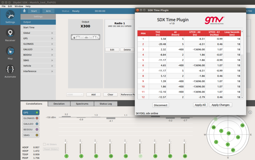
With Orolia’s Skydel SDX API, GMV has developed a “Time Plugin” that allows to batch edit the numerical values associated to TGDs, UTCO and Leap Seconds. (Image: GMV)
GMV uses the flexibility of Skydel SDX to simulate GNSS timing events.
The upcoming GPS Week Number Rollover (WNRO) on April 6 is a known feature of GPS that occurs only every roughly 20 years and thus can be anticipated and tested in a receiver using a GNSS simulator.
A less-known rollover effect is also present in the Week Number (WN) associated to the UTC Offset (UTCO) transmitted by GPS. This WN has only 8 bits, which implies a range of values from 0-255, equivalent to a rollover every roughly 5 years. A possible failure in the receiver interpretation of the UTCO WN would not have such dramatic effects as a general GPS WNRO, but it could seriously affect the output of a GPS timing receiver.
Other than WN rollovers, un-programmed GNSS timing glitches are extremely rare but not impossible. A well known case is the GPS anomaly of Jan. 25-26, 2016, when around half of the satellites in the constellation transmitted an incorrect UTCO value during 12 hours. The transmitted value was of the order of 13 microseconds, when the correct value is usually of the order of just a few nanoseconds. This caused many timing receivers around the world to provide an incorrect timing information or to fail altogether.
Other fields in the GPS navigation message that could potentially be corrupt and cause incorrect timing output are Timing Group Delays (TGDs), and Leap Second information. In general, any event related to the contents of the GPS navigation message can be simulated by editing the associated bits in the message, for each satellite PRN.
However this is a cumbersome and prone-to-error task. Orolia’s Skydel SDX simulator provides an Application Programming Interface (API) that allows to develop SDX extensions to tackle particular simulation problems in an easy and flexible way.
By using this API, GMV has developed a “Time Plugin” that allows to edit directly on a user interface the numerical values associated to TGDs, UTCO, and Leap Seconds, per individual satellite PRN. These values are then converted to bits in the GPS message and transmitted in the RF stream to feed the receiver under test. Events like, for example, the GPS anomaly of Jan. 25-26, 2016, can be easily tested (as shown in the screenshot).
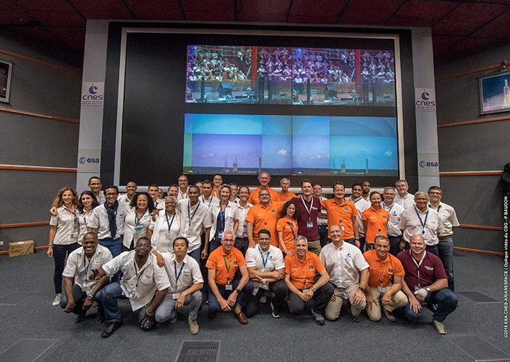
Countdown team at Kourou, Guiana control center for July’s four-satellite launch. (Photo: ESA/CNES/Arianespace, P. Baudon)
By Javier Benedicto Head, Galileo Programme department, European Space Agency
Since the declaration of initial services in December 2016, the European Space Agency (ESA) and the European GNSS Agency (GSA) have expanded Galileo’s system capabilities and service robustness with significant improvements of the ground segment and the last batch of four satellites launched by Ariane 5 in July. Once these satellites reach their final position and complete their in-orbit commissioning before the end of 2018, all 24 nominal slots of the Galileo constellation will be occupied.
Up to 22 satellites are planned to be commissioned in early 2019 and, eventually, the two FOC satellites injected in elliptical orbit should join the operational constellation after on-board software upgrade to provide for automatic health status flagging to users. This should lead to a total of 24 operational Galileo satellites supporting global PNT for users worldwide.
New Infrastructure Contracts
To further expand the system capabilities by 2020 and beyond, and reach Full Operational Capability (FOC), ESA has awarded new large industrial contracts in the context of the Exploitation Phase.
A contract to build and test another twelve Galileo satellites (so-called Batch-3) was awarded in 2017 to a consortium led by prime contractor OHB GmbH in Germany, with Surrey Satellite Technology Ltd in the UK as payload prime. These new satellites are based on the already qualified design of the previous Galileo FOC satellites. Production is advancing well, with first launch planned by late 2020.
With the Galileo constellation now expanded to 26 navigation satellites and plans to deploy additional Batch 3 satellites, the ground control infrastructure is undergoing a corresponding upgrades. In July, ESA awarded a new contract for the Galileo Ground Control Segment to GMV Aerospace and Defence, Spain. This contract includes upgrading the system architecture to manage a constellation of up to 41 Galileo satellites, updating obsolescent elements in the current system, improving operability linked to the provision of services and additional telemetry, tracking, and command capabilities to improve system robustness.
In October, Thales Alenia Space in France received a contract to upgrade the Galileo Ground Mission Segment and the Galileo Security Monitoring Centres (GSMC). This work includes upgrading Galileo’s system architecture to provide more accurate navigation products for broadcast by Galileo satellites, updating obsolescent elements in the current system and improving operability linked to the provision of services and enhanced robustness.
It will also include the construction of additional navigation message uplink and sensor stations. This contract will also augment the capabilities for implementation of the Public Regulated Service (PRS), the single most accurate and secure class of Galileo signals. Encrypted PRS signals will be made available only to authorized governmental users through approved national authorities. GSMCs in France and Spain will ensure the security monitoring functions for Galileo operational assets and manage PRS access and operations.
Growing Service Portfolio
The European Commission, GSA and ESA have jointly defined a broad range of service improvements and system capability enhancements to be deployed in 2019–2020, leading to FOC.
The newly qualified system infrastructure will support the broadcast of authentication information as part of the Open Service Navigation Message in E1; experimentation will start by end of 2019, leading to the possibility to offer trusted PNT to Galileo users.
Galileo will also be the first GNSS constellation to provide a Search and Rescue return link capability: as of 2019 the system will allow broadcast of acknowledgement of receipt message to users in distress with a very low latency, contributing to saving lives.
ESA has also started preparing the necessary modifications to the Navigation Signal Generation on-board the satellites to offer further capabilities to users after 2020. The signal-in-space will be enhanced with additional data transmitted in the I/NAV message, offering faster acquisition and more robust Galileo positioning on E1 and an encrypted navigation signal on E6 supporting authentication at signal level.
The new Galileo High Accuracy Service, soon entering the experimental phase, will consist in the delivery of un-encrypted high accuracy correction data in E6, enabling users to achieve sub-meter level positioning.
The usage of Galileo Open Service for aviation applications using horizontal advanced receiver-autonomous integrity monitoring techniques is being carefully assessed through measurements and review of the system design, including feared-events characterisation.
Longer Term Evolution
Galileo Second Generation has been the subject of technology pre-developments in the areas of platform and payload critical equipment, system techniques and processing algorithms, as well as system and segment Phase B studies over the past few years. We are now approaching the start of the implementation phase.
The European Commission, in close consultation with EU member states, has defined a decision roadmap aiming at very important future budget and programme implementation decisions in the course of 2019. In this context, ESA has launched a competitive procurement procedure for the first batch of so-called “Transition Satellites” with a broad range of enhanced and some new capabilities being considered. This includes improvements in the signal domain for faster acquisition and lower receiver power consumption, on-board clock technology, inter-satellite links, electrical propulsion, flexible payloads and power allocation by means of on-board digital technology and in-orbit re-configurability.
Transition satellites and related ground segment development contracts will begin by the end of 2019, aiming at in-orbit validation of second-generation capabilities from 2025 onwards.
EGNOS Evolution for Aviation
The adoption of Europe’s SBAS EGNOS by aviation is growing faster and faster. EGNOS will continue to evolve in the coming years. In particular, for 2019 and 2020, the evolutions under implementation focus on the obsolescence management of the hardware of some critical components, improvement of the system performances thanks to addition of new stations and system algorithms.
All these evolutions are planned to be qualified in 2021-2022, to continue to offer an excellent level of performance to Aviation Users until the operational take-over by the second generation of EGNOS V3,planned in 2025.
The European Performance-Based Navigation Implementing Regulation plans a growth from the current 35% to 66% in 2020 and 100% in 2024 of all European airports instrumental runways end-equipped with SBAS localizer performance with vertical guidance procedure.
On the aircraft manufacturer side, Airbus confirmed that it will continue equipping its aircraft; following the A350 family already equipped, both A320 and A330 families will be equipped for entry into service in summer 2020.
NAVISP
ESA’s Navigation Innovation and Support Programme (NAVISP), launched in 2017, will continue to boost member states’ industrial competitiveness and innovation in the upstream and downstream navigation sector, investigate the integration of satellite navigation with non-space technologies and complementary positioning and communication techniques, and study novel receiver-based techniques to counteract vulnerabilities and improve the robustness and reliability of GNSS.
Conclusion
The EU-built GNSS infrastructure systems EGNOS and Galileo are operational and serving users in Europe and worldwide. EC, GSA, ESA and European industries are committed to improvement plans over the next 2–3 years, with emphasis on endurance, resilience and robustness of the systems’ infrastructure, and delivering enhanced services.
For the longer term, the real challenge is to modernize the systems with new spaceborne and ground technologies, increase operational robustness and automation, and provide for additional system capabilities, while retaining a large degree of flexibility and in-orbit re-configurability to meet the long-term challenges and evolution of satellite-based navigation and timing.
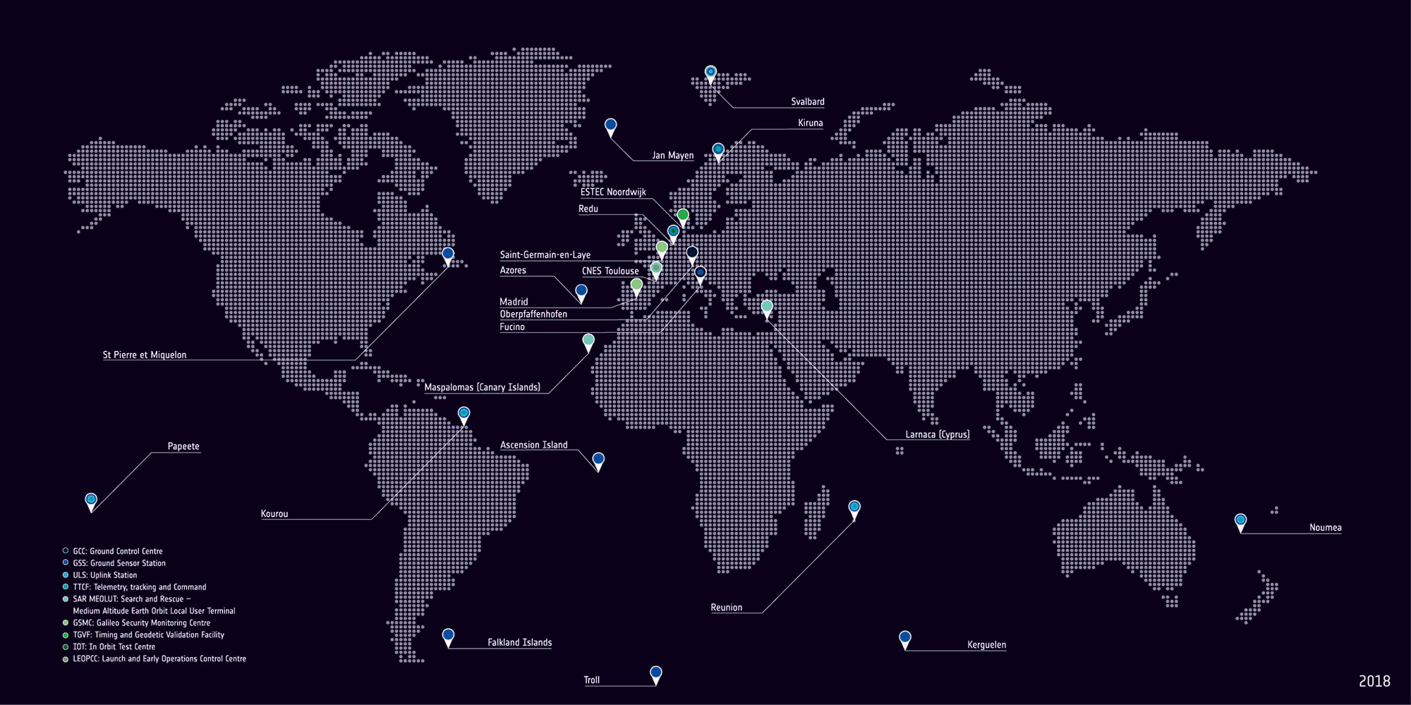
With Europe’s Galileo constellation in space now expanded to 26 navigation satellites — and Galileo Initial Services available to users worldwide — the infrastructure on the ground that controls them is undergoing a corresponding expansion.
ESA has awarded a new work order for the Galileo Control Segment — that part of the Galileo system responsible for the monitoring and control of all the satellites in orbit — to GMV Aerospace and Defence, Spain.
The contract was signed by ESA Director of Navigation Paul Verhoef and Jesús B. Serrano Martínez, CEO of GMV, in a ceremony hosted at Spain’s Ministry of Science, Innovation and Universities in Madrid, in the presence of Spanish Science Minister and former ESA astronaut Pedro Duque.
The ground control contract was signed Sept. 6 at at Spain’s Ministry of Science, Innovation and Universities in Madrid. From left: Verhoef; Secretary General of Transport of Spain’s Ministry of Public Works, María José Rallo, representing Spain in the EU Committee on Satellite Navigation Programmes; Spanish Science Minister and former ESA astronaut Pedro Duque; European Commission adviser on navigation activities Augusto González; and Martínez. (Photo: ESA)
Galileo’s Control Segment is hosted at the Oberpfaffenhofen Control Centre in Germany, with a “hot backup” in place at Galileo’s second Control Centre, at Fucino in Italy. It also extends to a network of Telemetry, Tracking and Control (TT&C) ground stations placed around the globe to stay linked with all satellites in the constellation.
The combination of these Control Centres plus TT&C stations are vital to keep Galileo running at its highest possible performance level. They monitor the overall status of the constellation, gather telemetry and uplink telecommands to each satellite, while also performing two-way radio and Doppler ranging to keep precise track of their position in space, identifying any orbital drift that might degrade the system’s accuracy.
The Galileo Control Segment has been designed to allow the automatic execution of routine operations. It also includes elements supporting flight dynamics analyses, constellation operations short-term planning as well as operations preparation.
Galileo’s global ground segment. (Map: ESA)
This first work order for the “Galileo Control Segment Exploitation Phase” contracts GMV Aerospace and Defence as prime contractor to undertake all necessary activities to upgrade the Galileo Control Segment as part of Galileo’s Exploitation phase.
This work includes upgrading the system architecture to manage a constellation of up to 41 Galileo satellites, updating obsolescent elements in the current system, improving operability linked to the provision of services and the addition of a new, second TT&C station to be based in Kourou, French Guiana.
The integration, qualification, deployment and migration into operational service of the various segments of the upgraded Galileo Control Segment will be undertaken over the next three years.
The Galileo ground station near New Caledonia capital Nouméa incorporates a Galileo Sensor Station (foreground) that monitors the quality of navigation signals and an uplink station (background) to relay navigation corrections to the satellites for rebroadcast to users. An antenna 13 meters in diameter for controlling the satellites has also been built, ready to come online later this year. (Photo: ESA)
This process is to undertaken while maintaining coherence with the other segments of the overall Galileo system – such as the Galileo Mission Segment which oversees Galileo services, the external control centres that carry out initial satellite switch-ons and in-orbit testing and the satellite platform and payload manufacturers, OHB System AG in Germany and Surrey Satellite Technology Ltd in the UK.
ESA has issued this work order in its role overseeing Galileo’s deployment, the design and development of future upgrades and the technical development of infrastructure on behalf of the European Commission, Galileo’s owner.
GMV, Tecnobit and Skydel are aiming to provide corporations, universities and research labs with a reliable, advanced simulation system that closely follows the latest Galileo capabilities.
“Together with our partners at Tecnobit, and taking advantage of SDX’s unique software-defined architecture, we are currently working to add Public Regulated Service (PRS) support to Skydel SDX,” said Manuel Toledo, head of the GNSS Advanced User Segment Solutions Division at GMV. PRS provides position and timing data for sensitive applications that require the highest level of service continuity.
Skydel and GMV are also joining efforts on developing SDX’s capabilities for signal authentication with Galileo Commercial Service and Open Service. The goal of such authentication is to increase the safety level of signals and to avert their falsification or fraud. It is currently a unique feature that only the Galileo constellation can provide, the companies said.
Skydel and GMV are also collaborating on projects that aim to provide signal simulation solutions for Galileo’s second generation (G2G). Galileo’s second-generation satellites are scheduled to be launched in 2025 and beyond.
“With Galileo’s full operational capabilities approaching soon, we must focus on the system’s upcoming G2G services,” said Pierre-Marie Le Véel, business development director at Skydel. “Skydel’s top priority for the European market is to provide simulation tools for the design of these next-generation GNSS devices.”
The partnership among the three companies unites the unique strengths of each organization, GMV said. While GMV brings its expert knowledge of both the European market and the Galileo system and Tecnobit brings its expertise as developer of cryptographic systems, Skydel adds its versatile and extensible GNSS simulator, resulting in a solid technical and commercial synergy for establishing an improved GNSS service offering for Europe.
CEVA Inc., licensor of signal processing IP forconnected devices, and Hong Kong Applied Science and Technology Research Institute Company Limited (ASTRI) have introduced Dragonfly NB1, a comprehensive cost- and power-optimized NB-IoT solution aimed at streamlining the development of LTE IoT devices.
Dragonfly NB1 leverages CEVA’s heritage of low-power DSPs and modem design and ASTRI’s experience in RF and IC Design technologies. Together, the companies have collaborated to produce a complete machine-to-machine (M2M) endpoint solution that offers best-in-class performance and power consumption, that is easily integrated into a system on chip (SoC).
GMV Add-On for GNSS. CEVA and ASTRI have teamed up with GMV, a navigation system and solutions company, to offer an integrated GNSS solution for smart devices with location tracking of logistics, assets, wearables and more. The GNSS IP is available as an add-on software that runs on the CEVA-X1 together with NB-IoT and leverages ASTRI’s GNSS RF IP that is embedded into the solution.
GMV’s software IP supports all four GNSS constellations: GPS, BeiDou, GLONASS and Galileo. The flexibility enabled by running the GNSS constellations fully in software on Dragonfly NB1 allows seamless switching between constellations when required or to run multiple constellations concurrently in order to improve resolution further and offer a truly global asset tracking solution.
“Dragonfly NB1 with its multi-mode RF and dedicated IoT processor is a perfect match with GMV’s software GNSS product,” said Miguel Manuel Romay Merino, executive director of GNSS at GMV. “It provides full flexibility in using multiple constellations, either separately or concurrently to serve the various requirements specific to asset trackers, wearables and other IoT endpoint devices.”
Dragonfly Features
Dragonfly NB1 not only reduces the time taken to get NB-IoT products certified, but also provides low-power wide-area (LPWA) SoC designers with a flexible, software-upgradeable platform with key benefits in terms of die size and power consumption:
The Dragonfly NB1 solution is enabled by a single CEVA-X1 IoT processor, capable of running the complete PHY and protocol stack software for NB-IoT in addition to other associated workloads such as GNSS and sensing. It eliminates the need for additional processors and hardware accelerators in the SoC and allows in-the-field upgrades to Release 14 eNB-IoT and other future releases.
The CEVA-X1 IoT processor architecture includes specialized NB-IoT instructions and mechanisms to speed up PHY, MAC and encryption execution, further reducing clock speed and power consumption. It can also support other LPWA standards and workloads such as Cat-M1, LoRa, SigFox and voice.
The Dragonfly NB1 solution incorporates highly power-efficient multi-standard RF with embedded PA, LNA, DC-DC and DCXO technology for NB-IoT and GNSS (GPS and BeiDou), shortening development time and reducing the overall module bill of materials.
Memory is a critical consideration for NB-IoT, as it directly influences the cost, silicon area and overall form factor of the module. Dragonfly NB1 is specifically designed to operate with embedded flash by incorporating an optimized low latency memory subsystem with a dedicated cache controller. The solution also includes a specialized security unit for a fully-trusted system.
“In the coming years, NB-IoT will become the dominant technology for low power wide area connectivity. For most companies, understanding how to develop this technology is a daunting task,” said Michael Boukaya, Vice President and General Manager, Wireless Business Unit at CEVA. “To overcome this, we have worked relentlessly with ASTRI to develop a complete solution from the ground up, that removes the design burden and allows SoC designers to add NB-IoT connectivity to their product designs. We’re extremely excited to announce this solution and demonstrate our leadership in IP for NB-IoT.”
“We’re pleased to partner with CEVA to address the cellular IoT market opportunity,” said Frank Tong, CEO at ASTRI. “Our joint development efforts have resulted in a highly-integrated modem solution with integrated RF that delivers outstanding performance and is power-optimized for the most rigorous NB-IoT use cases. We look forward to continuing our collaboration as we help our mutual customers get to market.”
Reference silicon of the complete modem design — including embedded CMOS RF transceiver, advanced digital front-end, physical layer software and third-party protocol stack (MAC, RLC, PDCP, RRC and NAS) — will be available this June.
Geoscience Australia, an agency of the Commonwealth of Australia, and Lockheed Martin have entered into a collaborative research project to show how augmenting signals from multiple GNSS constellations can enhance positioning, navigation and timing for a range of applications.
The research project aims to demonstrate how a second-generation Satellite-Based Augmentation System (SBAS) testbed can — for the first time — use signals from both GPS and the Galileo constellation, as well as dual frequencies, to achieve greater GNSS integrity and accuracy.
Over two years, the testbed will validate applications in nine industry sectors: agriculture, aviation, construction, maritime, mining, rail, road, spatial and utilities.
To improve precision navigation, a second-generation SBAS will use signals from both GPS and Galileo, and dual frequencies, to achieve even greater GNSS integrity and accuracy. (Graphic: Lockheed Martin)
“Many industries rely on GNSS signals for accurate, safe navigation. Users must be confident in the position solutions calculated by GNSS receivers. The term ‘integrity’ defines the confidence in the position solutions provided by GNSS,” says Vince Di Pietro, chief executive of Lockheed Martin Australia and New Zealand. “Industries where safety-of-life navigation is crucial want assured GNSS integrity.”
Ultimately, the second-generation SBAS testbed will broaden understanding of how this technology can benefit safety, productivity, efficiency and innovation in Australia’s industrial and research sectors, according to Lockheed.
“We are excited to have an opportunity to work with Geoscience Australia and Australian industry to demonstrate the best possible GNSS performance and proud that Australia will be leading the way to enhance space-based navigation and industry safety,” Di Pietro adds.
Basic GNSS signals are accurate enough for many civil positioning, navigation and timing users. However, these signals require augmentation to meet higher safety-of-life navigation requirements. The second-generation SBAS will mitigate that issue.
Once the SBAS testbed is operational, basic GNSS signals will be monitored by widely-distributed reference stations operated by Geoscience Australia. An SBAS testbed master station, installed by teammate GMV of Spain, will collect that reference station data, compute corrections and integrity bounds for each GNSS satellite signal, and generate augmentation messages.
“A Lockheed Martin uplink antenna at Uralla, New South Wales, will send these augmentation messages to an SBAS payload hosted aboard a geostationary Earth orbit satellite, owned by Inmarsat,” says Rod Drury, director of international strategy and business development for Lockheed Martin Space Systems Co. “This satellite rebroadcasts the augmentation messages containing corrections and integrity data to the end users. The whole process takes less than six seconds.”
By augmenting signals from multiple GNSS constellations — both Galileo and GPS — second-generation SBAS is not dependent on one GNSS. It will also use signals on two frequencies — the L1 and L5 GPS signals, and their companion E1 and E5a Galileo signals — to provide integrity data and enhanced accuracy for industries that need it.
Research partners
Lockheed Martin will provide systems integration expertise in addition to the Uralla radio frequency uplink. GMV-Spain will provide its magicGNSS processors. Inmarsat will provide the navigation payload hosted on the 4F1 geostationary satellite. The Australia and New Zealand Cooperative Research Centre for Spatial Information will coordinate the demonstrator projects that test the SBAS infrastructure.
Lockheed Martin has significant experience with space-based navigation systems. The company developed and produced 20 GPS IIR and IIR-M satellites. It also maintains the GPS Architecture Evolution Plan ground control system, which operates the entire 31-satellite constellation.
GMV, one of the world’s leading companies in satellite navigation systems, announced the tracking of both data and pilot channels of Galileo first satellite signal with its own line of GNSS receiver products.
The first two Galileo satellites were launched from Kouru Spaceport in French Guiana on October 21st and are now in in-orbit test campaign. The Galileo PRN 11 started transmitting the first navigation signal last Saturday.
GMV has been involved in GNSS for the last 25 years and today GMV’s GNSS team includes more than 120 highly specialized engineers, some having more than 15 years experience in the GNSS field. GMV plays a critical role in the ongoing development of Europe’s GNSS strategy, being a key partner in the EGNOS and Galileo programmes.
GMV has developed its own GNSS software receiver products: SRX-10 on GPS, which has been optimized for the urban environment, NUSAR for GPS L1 and Galileo E1 and its own L1 front end. This experience has been applied, even previously to the development of the receivers, to many studies on receiver performances under very diverse signal conditions and designs, namely by processing the GIOVE satellites signal.
Supported by its line of GNSS receiver products, GMV now presents its results on the first Galileo signals on both data (E1-B) and pilot (E1-C) channels of the Galileo PRN 11 satellite.