Mayflower Communications Company has delivered its Multi-Platform Anti-Jam GPS Navigation Antenna–Federated (MAGNA-F) to the U.S. Air Force Special Operations Command (AFSOC) in August 2017.
Mayflower’s MAGNA-F anti-jam antenna system.
Mayflowers’ GPS anti-jam system (MAGNA) provides protection for multiple military GPS receiver types (C/A and SAASM). The AFSOC platform has been proven in an operational environment.
MAGNA-F can provide protected GPS signals to different receivers simultaneously. It protects critical mission systems on the platform and provides unwavering position, navigation and timing (PNT).
The MAGNA-F system provides the fixed-wing platform with unsurpassed high-performance anti-jam capability.
“The MAGNA-F is easy to install as a drop in FRPA replacement, provides high-performance GPS anti-jam, and is very reliable,” said Joe Thomas, director of government programs for Mayflower.
The integration and testing of the MAGNA-F began in late January and February of 2017 and was led by the U.S. AFSOC Program Team at U.S. Special Operations Command (USSOCOM).
The flight testing proved the Mayflower MAGNA-F provides the highest level of PNT assurance for size, weight and performance (SWaP) constrained fixed-wing and UAS platforms.
The MAGNA-F is built on an open systems architecture and can be used with multiple military or civilian GPS receivers.
The MAGNA-F enables growth capabilities across a variety SWaP constrained platforms including rotary wing, fixed wing, and small to large unmanned aerial systems (UAS). The MAGNA AJ systems are also adaptable for U.S. Army ground vehicle AJAS requirements.
Over the past five years, Mayflower has delivered anti-jam systems across multiple aircraft (fixed wing, UAS) and U.S. Navy strategic-level submarine platforms.
The Mayflower family of anti-jam systems have a wealth of military live tests (flight and ground) and “real-world” operational experience. The Mayflower SAS (NavGuard 500), SAGE (NavGuard 501) and MAGNA-F (NavGuard 502) assures a Technology Readiness Level (TRL 8/9) product. Each of these systems are software upgradable with capabilities such as direction of arrival, jammer characterization, and operational with U.S. Army pseudolites.
Danlaw Inc. has released its Through Glass Integrated V2X Antenna for vehicle-to-vehicle and vehicle-to-everything (V2X) communications.
The design incorporates an integrated GNSS antenna on the interior coupler. Optional cellular, Wi-Fi, and other antennas are also available on request.
The antenna pairs with dedicated short-range communications (DSRC) devices to enable vehicle-to-vehicle, and vehicle-to-infrastructure communications.
Traditional aftermarket antennas require drilling holes or passing cables through window and door openings, which risks damaging vehicle seals.
Danlaw’s dual-radio, glass-mounted antenna eliminates the risk of damaging the vehicle by using a coupling pair-to-pass DSRC signals between the vehicle’s interior and exterior.
The easy-to-install antenna can be mounted on the rear, front or side windows using automotive grade glass adhesive. This flexible installation allows the shortest cable route to the V2X device, reducing signal losses due to cable length, the company said.
“Our customers running pilot programs want to install V2X DSRC systems on vehicles with best-in-class RF performance without modifying their cars,” said Scott Morell, Danlaw’s vice president of engineering. “Combined with our Aftermarket V2X Safety Device, this enables V2X capabilities to be installed on vehicles simply and easily.”
The antenna enhances Danlaw’s Connected Vehicle portfolio which includes an aftermarket safety device (ASD) and V2X development tools.
The ASD has been selected by pilot programs supporting multiple applications, including critical safety advice, driver access solutions, and real-time road condition and congestion information.
Danlaw development tools include the OmniAir-certified Mx-DSRC Conformance Test System and Mx-Drive Mobility Simulator.
Detailed specifications for the antenna are available.
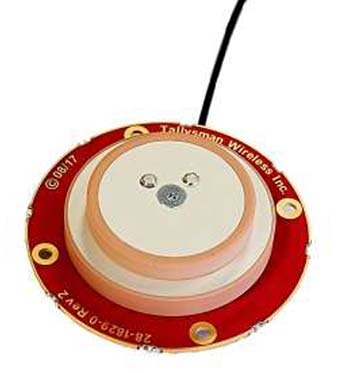
Tallysman, a manufacturer of high-performance GNSS antennas and related products, is offering a new light-weight compact GPS L1/L2 + GLONASS G1/G2 antenna, available either as an OEM (TW1829) antenna or in a housed version (TW8829).
The antenna is designed for unmanned aerial vehicle use because of its low aerodynamic profile and very light weight. The TW1829 weighs 37 grams and is 48mm (d) x 12.2mm (h). The TW8829 weighs 52 grams and is 47.3mm (d) x 18.3mm (h).
The antennas employ Tallysman’s Accutenna technology, which has proven its ability to provide high-level rejection of multipath signals, a phase linear response and tight phase centre variations (PCV).
Additionally, the antenna has pre-filters to prevent the saturation of the front end LNA by strong near frequency and harmonic signals.
The antenna is available with a choice of connectors and custom cable lengths. Additionally, Tallysman can custom tune the TW1829 for the customers’ enclosure to ensure optimal performance.
Helix Technologies Ltd., a U.K.-based developer of high-performance, ceramic-based helix antennas, has secured funding that will enable continued development of antennas for a wide range of applications including autonomous vehicles, drones, internet of things and machine-to-machine communications.
Photo: HelixAntenia
The company closed its Phase B funding round with GBP 650,000 of financing provided by private investors.
The company said that the driverless car segment, both GNSS and vehicle-to-everything (V2X) dedicated short-range communications (DSRC) applications, represents the most immediate and compelling need and business opportunity for its helix antenna technology.
Helix Technologies said its dielectric-loaded helix antennas will provide significant performance advantages over incumbent antenna technologies for next-generation GNSS and V2X applications.
The use of a dielectric ceramic core gives its antennas unique properties including unsurpassed gain/efficiency per unit of volume and more effective and predictable behaviour in a wide range of challenging user scenarios.
“We are grateful for the support of our investors which allows us to develop innovative solutions for this exciting growth market,” said John Yates, managing director of Helix Technologies. “The first self-driving cars are widely forecast to be on the market between 2019 and 2021. Any navigation and communications equipment used onboard will have to fulfil the highest-possible standards on safety, integrity and accuracy.”
The company expects to have prototypes of its V2X DSRC antenna available by the second quarter of 2018 and its NEXTGEN GNSS antenna by the third quarter of 2018.
According to the company, the use of the ceramic core enables the fabrication of antennas that are physically smaller than conventional antennas, behave much more effectively and predictably in a wide range of challenging user scenarios and have many compelling technical advantages which include:
Maintaining radiation efficiency near absorbing objects (such as the human body)
Improving the accuracy of GNSS systems in multipath environments (such as in cities)
Operation in sub-optimal orientations towards the sky
Are able to be placed into very tightly integrated systems
Operation in slim devices without a ground plane
Unsurpassed gain/efficiency per unit of volume
Simple and robust design and construction for durability and reliability
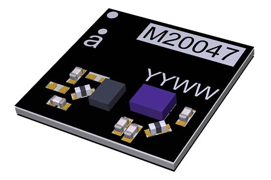
Antenova Ltd., manufacturer of antennas and RF antenna modules, has launched a new compact, all-in-one active GNSS antenna, part number M20047-1, at the Consumer Electronics Show (CES) show, Jan. 9-12, in Las Vegas.
The M20047-1 antenna adds another option to the company’s existing range of positioning antennas and modules.
It operates in the 1559–1609 MHz bands, and offers designers a useful, space-saving option for small tracking devices.
It’s key features are the active components, the built-in LNA and filter, which act to boost the signal to the GNSS processor in environments where there is a restricted view of the sky and line-of-sight to the horizon is difficult. With the LNA and filtering already built into the antenna, designers will not need to add them, and can save space on their PCB.
The M20047-1 is a very low profile rigid FR4 antenna measuring 7.0 x 7.0 x 1.1 millimeters, making it suitable for use in small tracking devices. It is suitable for tracking all kinds of moving objects, telematics and wearable sports devices.
The M20047-1 antenna is named Active Sinica and is an alternative to Antenova’s existing Sinica antenna, part no SR4G008, which is marketed for accurate positioning.
Antenova’s antennas are specifically designed for easy integration; however, the company provides full engineering support to help customers with all aspects of antenna testing, tuning and integration.
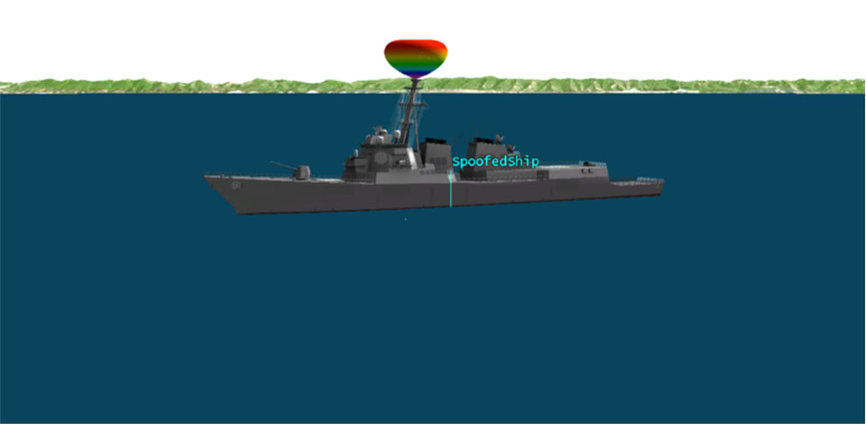
We’ve heard a lot in the news recently about GPS spoofing, mostly centred on the story of ship spoofing in the Black Sea. Between June 22-24, a number of ships in the Black Sea reported anomalies with their GPS-derived position, and found themselves apparently located at an airport.
What happened is open to educated conjecture. In this column, I’ll briefly cover the history of spoofing, its basic techniques, some spoofing tests that we conducted, and then return to the infamous Black Sea incident.
As part of my day-to-day work in navigation warfare, I do a fair amount of work in defensive anti-spoofing. Naturally, in order to test anti-spoof technology, it is necessary to also perform spoofing. It’s a delicate subject and, as with any topic involving defense or national security or critical infrastructure, there’s a balance to strike between responsible disclosure, how much information is released into the public domain, and so on.
In this article, I will stick firmly to information available in the public domain, lest I be accused of proliferating the threat, but this still gives us enough material to tiptoe around the subject for the benefit of our readers. I could have included more details about the spoofing attacks, but was advised to hold some back — it makes governments nervous. You can read some of the background in an excellent article by Norwegian broadcaster NRK and a Resilient Navigation and Timing Foundation press release. Similar GPS anomalies still continue to occur at various locations.
Let’s start with basic spoofing background, and we’ll return to the Black Sea incident at the end of the article.
A brief history of spoofing
Spoofing isn’t a new threat — it’s been around for decades. But only in recent years has it received so much public attention. As with jamming and anti-jamming technology, and most other topics in the GPS domain, spoofing finds its roots back in the days of Cold War radar. In those times, it was often known as “deception jamming,” where you would transmit fake radar returns to paint an incorrect picture on your adversary’s radar screen.
When GPS came along, it was understood at the time that the C/A code would be vulnerable to spoofing. It’s an open code, so anyone is free to reproduce it. That is, after all, what a GPS simulator is: a GPS spoofer. We legitimately test our GPS receivers by fooling them with fake signals from a GPS simulator.
Of course, this is precisely why legacy GPS satellites also transmit the military P(Y)-code, and continue to do so. The P-code offers improved accuracy, and some other benefits, but more importantly, it is modulated with the W encryption sequence to give us the encrypted P(Y)-code. Ever since the anti-spoofing module was set to the “on” state, unless you have the key, you are unable to directly spoof the P(Y)-code. (You can still perform a meaconing attack, though, where you simply record the transmitted satellite signals and retransmit them again. Although this kind of attack can’t be used to impose a particular scenario on a GPS receiver, it might still cause havoc in unwary receivers).
So. in the early days it can be argued that the spoofing threat was solved. It wasn’t until GPS became ubiquitous in the commercial and civilian domain that spoofing really raised its head again. The fact that the vast majority of GPS receivers in the world relied solely on the unencrypted C/A code became a cause for concern — especially where those GPS receivers were essential to critical infrastructure.
The threat of GPS spoofing was discussed at many conferences and behind many closed doors and, although most people agreed that spoofing was a theoretical threat, some people argued that in reality it was “simply too hard” to conduct a realistic spoofing attack. And therefore we should not worry ourselves about it.
It wasn’t until a couple of high-profile demonstrations were carried out by the University of Texas Radionavigation Laboratory that spoofing became front-page news once again. In 2012, the lab staff carried out an exercise at White Sands Missile Range where a GPS-guided drone was spoofed from a distance. The drone was fooled into thinking its altitude was increasing, causing it to compensate by dropping straight down. Then in 2013, the same team demonstrated how an $80 million yacht could be steered off course by means of a spoofing attack.
These exercises publicly demonstrated that spoofing was indeed a real threat, and could be done. But many people still believed that it was very hard to build the complex equipment necessary to perform the attack, and thus spoofing was out of reach for most potential criminals or terrorists.
Fast forward another two or three years, to when a new mobile phone game appeared. Pokemon GO became the game craze of the moment, where players would travel around the country with their phones, getting points by collecting creatures in an augmented reality world. It didn’t take long for people to dream up new ways of earning points in the game, without having to go to the effort of traveling around the world.
What if you could make your phone think it was somewhere else, without ever having to leave your bedroom? And thus, bizarrely, it was a mobile phone game that brought GPS spoofing into the mainstream.
The rise of the low-cost software-defined radio (SDR) has enabled “spoofing for everyone.” Today, the tool of choice for the casual user is often the HackRF or bladeRF. Couple small SDRs that cost around $200 with open-source GPS simulation software, and you have a basic spoofer. Plenty of websites detail how to perform basic spoofing, and at hacker gatherings, people can present how they spoofed a drone. These may not be the most sophisticated setups, but it’s good enough to do the job in many cases. With a better setup, which I won’t describe here, it’s possible to achieve a much more realistic attack, which will fool even the most shrewd and wary GPS receivers.
Spoofing basics
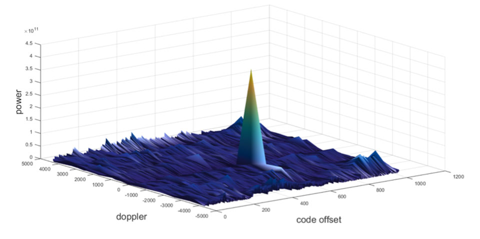
Let’s take a quick look at what it means to spoof GPS. A receiver searches for a satellite over a two-dimensional surface to find a correlation peak, and it must examine a range of Doppler frequencies and code offsets. An example is shown in Figure 1. Once the receiver finds the peak, the satellite is acquired, and it will then track the satellite as it moves and can demodulate the navigation data message.
When a spoofer comes along, it tries to recreate this peak. By doing so, and usually with little more power than the real satellites, the receiver will begin to track the spoofed signal. Once the spoofed signal is being tracked, the spoofer can begin to manipulate reality by slowly modifying the properties of the signal.
Figure 1. GPS correlation surface. (Image: Michael Jones)
A poor spoofer doesn’t always align itself very well with reality, which essentially creates a second peak on the correlation surface. But a gullible receiver can still be fooled by this, and may lock on to false peaks.
The reality of spoofing and anti-spoofing
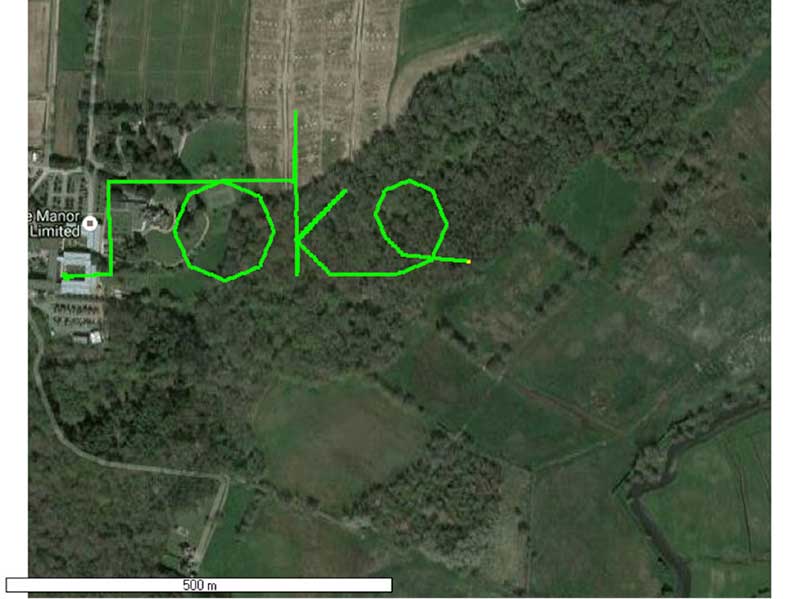
To understand the reality of spoofing and anti-spoofing, we carried out outdoor experiments at one of the Roke Manor trials areas (thanks go to my colleague Mike Wells for letting me use some of his results here).
In the first experiment (Figure 2), we spoof a commercially available mass-market receiver. The receiver is outside, reporting its correct location at Roke Manor. When we commence the spoofing attack, we are able to take control of the receiver. Once captured, we can then make the receiver appear to follow an arbitrary course. Here we make it wander off into the forest, spelling the word “roke” as it goes.
Figure 2. Spoofed GPS receiver appears to follow a course, whilst in reality being stationary. (Image: Michael Jones)
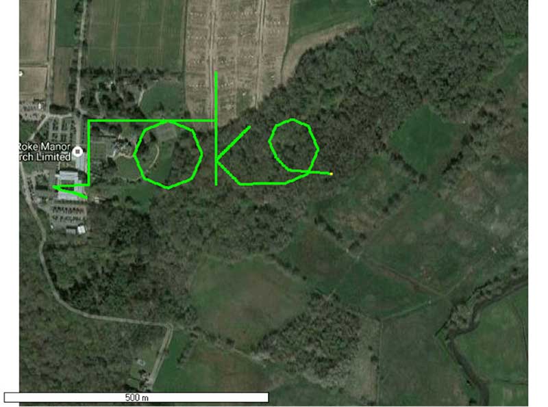
In the next experiment (Figure 3), we place a conventional anti-jam antenna (a CRPA) on the receiver. What we observe, as you might expect, is that the basic CRPA offers no protection against the spoofing attack.
Figure 3. A GPS receiver is still successfully spoofed when protected by a conventional CRPA. (Image: Michael Jones)
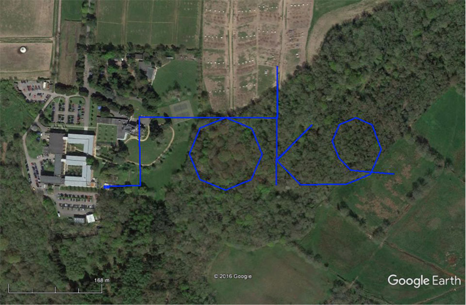
Now let’s make the experiment more interesting. We’ll move away from the basic commercial receiver, and replace it with a unit that contains not only a GPS receiver, but also a 3-axis accelerometer, 3-axis gyro, 3-axis magnetometer and a barometric sensor. An Extended Kalman Filter (EKF) performs an optimal fusion of the various sensors to yield the position solution.
The result, when we again try our spoofing attack, is shown in Figure 4. In short, the receiver is still successfully spoofed, despite the additional sensor inputs it offers.
Figure 4. A GPS receiver with integrated inertial sensors is still spoofed. (Image: Michael Jones)
Before everyone gets too depressed by the ease at which GNSS, and even GNSS fused with other sensors, can be spoofed, there are answers to this problem. Some decent, modern GNSS receivers contain a whole host of algorithms for detecting and ignoring spoof signals. The issue is that many legacy receivers are still in the field, and these can be extremely vulnerable indeed.
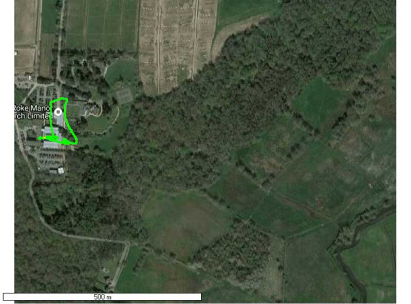
Another option is to use a more advanced CRPA, which offers anti-spoof capabilities. These adaptive antennas are able to correlate on the spoof signals, and then remove them based on direction of arrival. So, in our final experiment here, we use our commercial mass-market receiver again, and protect it with an anti-spoofing CRPA.
The result is shown in Figure 5. You can see that the receiver is briefly spoofed, and starts to wander off course. When the anti-spoof is enabled and kicks in, the position quickly drifts back to the true location and stays there. Good job.
Figure 5. With an anti-spoof CRPA, the GPS receiver detects the spoofer and quickly returns to its true location. (Image: Michael Jones)
Back to the Black Sea
Let’s finish by returning to the hot topic of the day. Did spoofing occur in the Black Sea back in June? Or was it a different form of interference? Could it have been a low-level jamming incident, causing the GPS receivers to report misleading information?
Without resorting to SIGINT (signals intelligence) data, and basing this discussion solely on public domain information and anecdotal evidence, I would say this was almost certainly a spoofing incident. A number of factors lead to this conclusion, and I’ll share some of them.
Firstly, it didn’t happen to one ship – it happened to over 20 separate vessels. So it wasn’t a malfunctioning GPS unit; it was an external incident of some kind.
Secondly, a large number of ships in the area reported identical or very close locations. This is a symptom of a large-scale spoofing attack. If it was a low-level jamming attack, then any misleading positions reported by vessels would typically have some randomness to them.
Thirdly, ships reported that their positions would periodically “jump” from the true location to the incorrect location. Again, this is very typical behavior in some spoofing experiments: For various reasons, GPS receivers may temporarily lose lock on a spoof set of satellites, and then reacquire the real ones, and vice versa. This causes the characteristic random flipping between two well-defined locations.
If we accept that a GPS spoofing attack did occur, it brings us to the million-dollar question.
Who did the spoofing, and why?
What I’ll do here is a bit of a lightweight analysis exercise using public information and basic physics, and you can formulate your own conclusions.
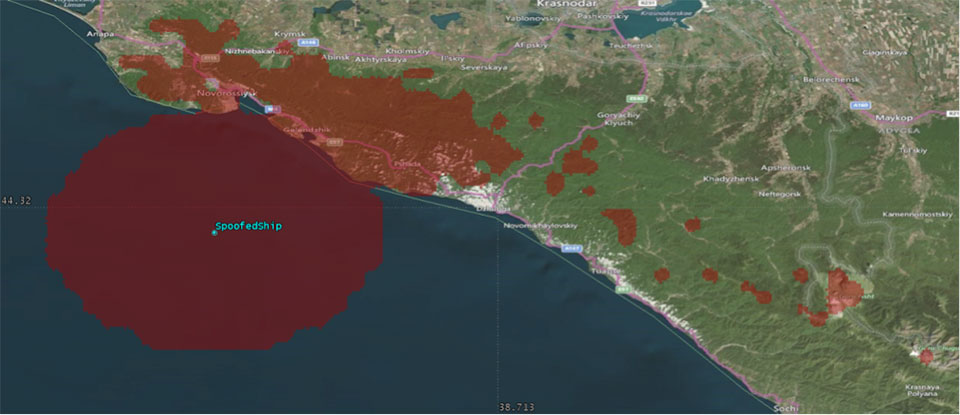
Let’s start by placing a ship, located in the Black Sea at 44°14.0’N 037°43.1E, which is the actual position of one of the reported spoofed vessels. For this example, I have placed a representative GPS antenna on the ship’s mast, with its antenna pattern shown.
Figure 6. Victim ship in the Black Sea, with GPS antenna pattern shown. (Image: Michael Jones)
To get a rough handle on the scenario, consider the possible propagation of the spoofing signal. As a first-order approximation, let’s assume a standard 4/3 Earth refraction model, with obstruction by terrain. That’s a reasonable assumption at this frequency: Any obscuration by terrain will block the spoof signal. Let’s also initially assume that our GPS antenna on the ship is mounted 38 meters above sea level, and our spoofing equipment is mounted on a mast 20 meters aboveground. From this information, we can plot a map of possible spoofer locations for this particular incident (Figure 7).
Figure 7. Possible spoofing source locations. (Image: Michael Jones)
The first thing we might conclude from this is that the spoofing indeed originates from Russian territory, close to the Black Sea coast. To spoof the ship from further afield would require a much higher antenna, or even an airborne antenna. Which, of course, is possible, but then we would also expect vessels over a much wider area to report interference.
To me, it’s fairly conclusive that spoof GPS signals are being transmitted from this area, to make GPS receivers in the area think they are at an airport. The final question is: “Why would someone do this?” To answer this question, we must resort to educated speculation. Why would you want to spoof GPS receivers into thinking they are at an airport?
There’s one explanation that fits very nicely: drone defense. Many drones, especially those operated by casual users, have geofencing rules that prevent flights over airports and other restricted areas. So, if you were trying to perform aerial surveillance of the Russian border, your drone may suddenly think it was over an airport, and take action accordingly. The action taken depends, of course, on how the drone is programmed, but often includes “land immediately” or “return to launch point.” Certainly some of the drones we operate will immediately attempt to land if they find themselves in restricted airspace.
So if your drones are falling into the sea, you now have one idea why.
Harxon has released the multi-constellation D-Helix Antenna at the 2017 Intergeo trade show, held Sept. 26-28 in Berlin, Germany. The Harxon booth is located at Hall 4.1, Stand C4.013.
The industrial, innovative D-Helix Antenna is capable of superior tracking of signals from GPS L1/L2 L-Band, GLONASS L1/L2, BDS B1/B2/B3 and Galileo. The innovative quadrifilar helix antenna design of low wind-resistance is ideal for UAV positioning and navigation.
The increased antenna gain and beamwidth ensure a better signal receiving performance of satellite at low elevation angle. The low noise figure enhanced transmission interference reduction and improve the signal quality.
The D-Helix antenna can be used in UAV patrol, UAV plant protection, unmanned patrol robot and unmanned surveying vessel. According to the company, it provides the centimeter-level positioning accuracy for a stable flightpath and prevents air turbulence, to enable a reliable positioning, height setting and heading information.
The antenna has been recognized by many industry experts and received inquiries from potential partners at the first launch day.
Other showcased products from the Harxon GNSS family include its survey antenna, rover radio, frequency hopping modules, smart antenna and H-RTK, are also appropriate for the fields of surveying and mapping, precision agriculture and UAVs.
Taoglas, a provider of IoT and M2M antenna products, has launched a range of high-performance GNSS antennas specifically designed to power the next generation of applications that require highly accurate location capabilities.
These applications include navigation, unmanned aerial vehicles (UAVs), surveying, agriculture, connected cars and autonomous vehicles.
The new antenna range is Taoglas’ most comprehensive series of high-precision GNSS antennas and incorporates new form factors and use of multiple RF bands.
Taoglas’ new range includes systems and antennas that use Galileo, GLONASS and BeiDou, as well as GPS L2 or L5 bands.
“Today’s connected devices and applications demand new ways of approaching the age-old problem of location accuracy,” said Dermot O’Shea, co-CEO for Taoglas. “In certain applications, there is simply no room for positioning errors — location accuracy is an absolute requirement.”
The GRS.10 smart antenna. (Image: Taoglas)
The new antenna range includes:
The GRS.10, a smart antenna that includes a high-performance Taoglas GNSS (GPS, GLONASS, Galileo, BeiDou) ceramic patch antenna module integrated with a u-blox NEO-M8U GNSS receiver.
The Torpedo series GNSS quadrifilar helical antennas, extremely high-performance wideband satellite antennas for position-information-critical applications. It provides high circularly polarized antenna gain across a wide beamwidth. These are available in a passive (QHA) or active (AQHA) versions.
The BOLT A.90.A.10451111, a new GNSS timing antenna that includes lightning-induced surge protection. It is designed for the base station market. The advantage over other timing antennas is the addition of GLONASS and BeiDou frequencies.
The complete range of precision GNSS antennas also includes:
The MAT.12A. (Image: Taoglas)
The ASFGP.36A.07.0100C, a ceramic GPS L1/L2 low-profile, low-axial-ratio, embedded stacked active patch antenna.
The MAT.12A, a GPS/GLONASS/BeiDou dueling-loop chip antenna evaluation board, which delivers the advantages of a circularly polarized patch antenna with two miniaturized low-profile chip antennas on a smaller PCB footprint at one-fifth the weight.
This week, Taoglas also launched small form-factor ultra-wideband (UWB) antennas designed to work with DecaWave’s chipset and module solutions for applications including asset tracking, follow-me drones, healthcare monitoring, smart home services and other applications that demand high-performance indoor localization capabilities.
Taoglas’ complete range of GNSS and UWB antennas will be on display in Booth N.614 at Mobile World Congress Americas, Sept. 12-14, in San Francisco.
Tallysman, a manufacturer of high-performance GNSS antennas and related products, has released two high-gain (50dB) GNSS antennas: the TW3152 and TW3752.
High-gain GNSS antennas are useful in situations where long cable runs are required, such as in timing systems and GNSS re-radiator systems, the company said.
The TW3152 provides reception of GPS L1. The TW3752 provides reception of GPS L1, GLONASS G1, BeiDou B1 and Galileo E1 signals. Both antennas employ Tallysman’s Accutenna technology, which provides a high degree of multipath signal rejection through the full bandwidth of the antenna.
According to Tallysman, the antennas are triple filtered to prevent the saturation of the front-end LNA by strong near frequency and harmonic signals, which are a growing concern throughout the world.
These antennas are available with a choice of radome shape (flat or conical), color of radome (white or grey), as well as a wide variety of connectors.
Facebook’s Open Cellular group is developing a cost-effective, software-defined, wireless-access platform to improve connectivity in remote areas of the world, the company said.
The TW2643POC employs Tallysman’s Accutenna technology in a magnet mount, passive right-hand circularly polarized antenna for the reception of all of the GNSS constellations (GPS L1/GLONASS G1/ Galileo E1/ BeiDou B1) plus Iridum: 1559 to 1626.5 MHz frequency band.
According to Tallysman, it is certified and specially designed to maximize the performance of Iridium Voice and Data Modems plus the upper GNSS band (1559–1606 MHz).
The TW2643POC is housed in an IP67 compliant housing and is REACH and RoHS compliant.
PCTEL Inc. is offering a new multi-band LTE/Wi-Fi/GNSS antenna with a sub-inch profile. The antenna combines PCTEL’s high rejection multi-GNSS technology for precision timing and location tracking with high performance multi-band data connectivity.
The antenna is also rugged and easy to install, making it suitable for covert public safety operations, precision agriculture and the industrial Internet of Things (IoT).
“Complex, high performance antennas are critical for modern public safety communications, as well as for commercial applications such as mobile asset management,” said Rishi Bharadwaj, senior vice president and general manager of PCTEL’s Connected Solutions group. “However, vehicles and autonomous systems have limited space for antenna installation. PCTEL’s sub-inch antenna addresses these space limitations while delivering high performance multi-band coverage. PCTEL also offers external and embedded antenna system design services for customers with more severe antenna size constraints or other specialized requirements.”
Within its ruggedized ultra-low profile housing, PCTEL’s new antenna supports multi-band LTE MIMO and dual-band 2.4/5 GHz Wi-Fi for data connectivity, as well as GPS, GLONASS, BeiDou and Galileo GNSS satellite technologies.
All GNSS elements feature PCTEL’s proprietary high rejection technology to ensure reliable satellite connectivity in the presence of LTE signals or other interference. The antenna has been fully tested for use in extreme environments and on heavy agricultural equipment.
PCTEL will display its new multi-band LTE/Wi-Fi/GNSS antenna along with other antenna solutions for public safety communications at APCO 2017 in Denver Aug. 14-15, in booth #1943. The antenna can be ordered using part number GNSMB-COV beginning Aug. 15.
The Apex tracker has Taoglas inside. (Photo: STATSports)
When the world’s best athletes take the field, many are equipped with a GPS-based performance monitor that tracks a wealth of data. By monitoring in real time the players’ actions, professional sports teams can collect and analyze data that gives them an edge over the competition.
STATSports is a provider of GPS player tracking and analysis solutions for some of the biggest sports franchises in the world. Teams in the English Premier League, La Liga, National Football League, National Basketball Association and other leagues rely on STATSports to help them improve performance and strategy, and reduce injuries.
Tracking Key Metrics. STATSports’ Apex System includes the Apex Pod and Apex Software. The Apex Pod is an ergonomically designed unit that curves to fit players’ backs. The pod is inserted into a specially designed vest or base layer.
It tracks a variety of metrics, including a player’s total distance, speed, accelerations, decelerations, heart rate, fatigue level and other variables that teams can use in real time or alongside post-game reviews. The data is processed through Apex Software, which creates reports and visual tracking mechanisms to compare players, track players over time and provide metrics personalized for each team.
A tablet app gives coaches portable functionality. (Photo: STATSports)
Apex Live Streaming uses multiple channels and synchronized mesh networking to deliver data streams from players to Apex Software for analysis. Apex delivers GPS speed and positional data; heart-rate variability; and digital compass, gyroscopic and accelerometer data. It transmits half a million numbers every minute during training and games for a squad of more than 30 players.
Accurate Antenna
In devices so small and sensitive, antennas can be the most common point of failure in the communications chain, said Dermot O’Shea, co-CEO of Taoglas. STATSports evaluated several antenna options before selecting Taoglas.
Taoglas’ 25×25-mm AGGBP.25B is a two-stage 28-dB active GPS patch antenna module that provides positional accuracy in a small form factor.
With a few dozen players and coaches on the field in training and at games, highly accurate positioning is critical. Players move quickly and are often clustered around a ball, making it difficult to accurately track player movement. STATSports required location accuracy within 1 meter, precision that
Taoglas delivered.
The LA Galaxy team uses STATSports. (Photo: LA Galaxy)
Because the STATSports technology captures data in real time, teams can make real-time tactical and strategic decisions and adjustments instead of waiting for post-game analysis.
However, with that many antennas and transmissions in close proximity, interference can be an issue. Taoglas’ solution includes a front-end surface acoustic wave (SAW) filter in front of the two-stage low noise amplifier (LNA) to reduce out-of-band noise, such as signals from nearby cellular transceivers.
The real-time nature of STATSports’ solution means the company also requires a condensed time to first fix — when the devices are turned on, STATSports needs them to register a signal quickly and begin to receive data. The Taoglas antenna is ready within 30 seconds of powering on.
STATSports’ proximity to Taoglas’ Wexford, Ireland, headquarters and development labs means the teams can collaborate on new functionality as STATSports develops increasingly advanced performance-tracking solutions.