Tag: GNSS module

  • U-blox launches its smallest GPS module, the MIA-M10

    U-blox launches its smallest GPS module, the MIA-M10

    Photo: u-blox
    Photo: u-blox

    U-blox has announced its smallest GNSS module series to date, the u-blox MIA-M10.

    Built on the ultra-low-power u-blox M10 GNSS platform, MIA-M10 offers a power-efficient solution for size-constrained battery-powered asset tracking devices. The module targets an expanding market for people, pet and livestock trackers, as well as industrial sensors and consumer goods.

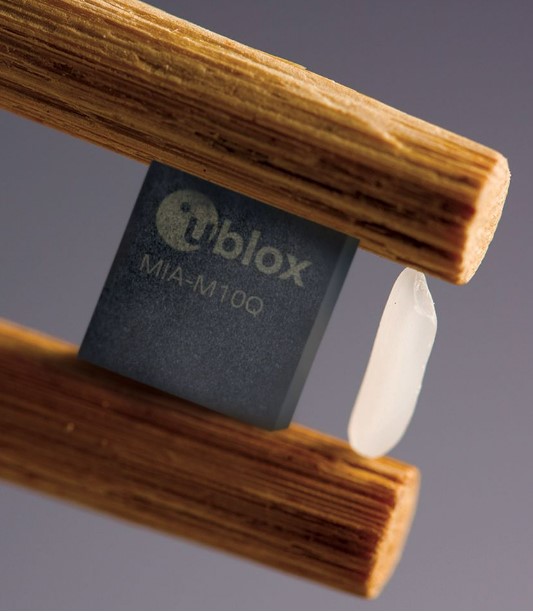
    The 4.5 x 4.5-mm form factor of the M1A-M10 allows developers to design more attractive and comfortable solutions, further driving the adoption of positioning technology in consumer and industrial solutions. The module offers ultra-low power consumption without compromising GNSS performance, the company said. Moreover, its power-save modes can double the battery life by optimally balancing position accuracy and power consumption.

    Like all u-blox M10 modules, the MIA-M10 concurrently receives four GNSS constellations (GPS, Galileo, BeiDou and GLONASS) for maximum satellite signal availability. Combined with its superior RF sensitivity, the module offers robust positioning performance for solutions with small antennas as well as for devices operating in weak signal environments such as deep urban canyons.

    Support for u-blox AssistNow assisted GNSS service, which delivers orbital data via the internet, cuts the time it takes the MIA-M10 to determine its initial position at startup, allowing it to immediately track satellites without having to wait for slow satellite data downloads to complete. And applications requiring extra-long power autonomy can use u-blox’s CloudLocate service, which extends the life of internet-of-things applications by offloading power-hungry position calculation to the cloud.

    The chip-sized, ready-to-use GNSS module requires no external components, reducing engineering and testing efforts, saving costs and resources, and speeding time to market.

    Two Variants

    MIA-M10 is available in two product variants.

    • The MIA-M10Q is for a growing market of highly size-constrained battery-powered tracking devices, wearable devices and highly dynamic applications such as small drones, cameras, bike computers and battery-powered sensors.
    • The MIA-M10C targets customers requiring more flexibility to combine the module with an active or custom antenna circuit.

    The MIA-M10 will be on display at the Sensors Converge and Embedded Technologies trade show in San Jose, California, at booth 1228. First samples will be available in July.

  • New Telit GNSS receiver provides advanced power modes

    New Telit GNSS receiver provides advanced power modes

    Photo: Telit
    Photo: Telit

    Telit has released the SE873K5 multi-constellation GNSS receiver in the L1 band. The SE873K5 simultaneously tracks and navigates all four GNSS constellations — GPS, Galileo, GLONASS and BeiDou — providing GNSS information over a UART, I2C or SPI interface serial port using the NMEA protocol.

    Based on the AG3335 system-in-package from Airoha, the SE873K5 is the latest addition to Telit’s SE873 family of modules and the natural migration path from SE873 and SE873Q5.

    The module is a 7mm x 7mm x 2.25mm QFN-like semiconductor package with embedded SPI flash, RTC and TCXO. With its compact size, the latest generation chipset and the advanced power modes, the SE873K5 has the benefits of low cost, small form factor and good electrical and thermal performance — suitable for wearables, fleet tracking, drones and more.

    The SE873K5 low-power processing core delivers customizable power-saving modes. It optimizes current draw at module wake-up by supporting both local- and server-based assisted GNSS (A-GNSS) for improved time to first fix, while satellite-based augmentation system (SBAS) corrections from WAAS, EGNOS, MSAS or GAGAN increase positioning accuracy.

    The internal flash memory allows firmware updates and customization, as well as ephemeris predictions storage.

    Features of the SE873K5 include:

    • Frequency bands: GPS L1, GLONASS L1, Galileo E1, BeiDou B1, QZSS L1
    • Standards: NMEA
    • SBAS (EGNOS, WAAS, GAGAN and MSAS) or QZSS L1S capability
    • Real-time clock for efficient power management
    • Low-power modes
    • Jammer rejection
    • Local and server-based A-GPS/A-GNSS
    • RoHS compliant
    • RED/UKCA certification
  • New Septentrio receivers support Japan’s CLAS

    New Septentrio receivers support Japan’s CLAS

    The mosaic-CLAS GNSS module. (Photo: Septentrio)
    The mosaic-CLAS GNSS module. (Photo: Septentrio)

    Septentrio, a leader in high-precision GNSS positioning solutions, has launched three new products that support Japan’s high-accuracy Centimeter Level Augmentation Service (CLAS).

    The three multi-frequency GNSS receivers support CLAS on a single device, thanks to the latest GNSS technology which receives the L6 signal, which transmits high-accuracy corrections from Japan’s QZSS constellation. This technology was developed in close cooperation with CORE, a leading integrator of high-accuracy positioning technology and services in Japan.

    • The mosaic-CLAS receiver is a GNSS module with a very small form-factor suitable for high-volume industrial applications.
    • The AsteRx-m3 CLAS is Septentrio’s best-in-class OEM board combining PPP-RTK CLAS with dual-antenna heading functionality.
    • The AsteRx SB3 CLAS features a ruggedized IP68 enclosure to protect it in harsh environments.

    Septentrio is simultaneously offering various receiver types to the Japanese market ensuring an optimal match between products and customer needs in various applications including robotics, precision agriculture, construction, machine control and UAV.

    “We are very pleased to jointly develop CLAS software on a new GNSS module, mosaic-CLAS,” emphasized Takahiro Yamamoto, director, GNSS Solution Business Center at CORE Corp. “This receiver puts CLAS GNSS technology on par with regular RTK receivers in terms of size as well as price. We believe that the realization of CLAS on the Septentrio mosaic platform will significantly promote the use of new QZSS services for industrial applications.”

    “The launch of our new module and OEM board with CLAS support opens up new markets and use cases, which will benefit from centimeter-level positioning with fast acquisition time,” commented François Freulon, head of Product Management at Septentrio. “This launch demonstrates the technological leadership of Septentrio and our ability to provide dedicated solutions embedding L6 bands for the Japanese market.”

    The CLAS PPP-RTK is the latest generation of GNSS correction services, combining near-RTK accuracy and quick initialization times with the broadcast nature of PPP. Receivers with built-in CLAS functionality offer sub-decimeter positioning accuracy right out of the box. Corrections for high-accuracy positioning are received directly from satellites, reducing the need for additional base stations or service subscriptions.

    Find out more about PPP-RTK and other positioning correction methods in the insight article GNSS Correction Demystified.

  • Quectel and Point One bring precise location to robotics and agriculture markets

    Quectel and Point One bring precise location to robotics and agriculture markets

    Photo: Quectel
    Photo: Quectel

    Quectel Wireless Solutions, a supplier of IoT modules and antennas, and Point One Navigation, a provider in precision location technology, have announced the LG69T-AM, the latest addition to the LG69T GNSS Module Series. Point One’s positioning engine powers the LG69T-AM and enables centimeter-level global accuracy by integrating augmented GNSS in a module with open-source API.

    The LG69T-AM GNSS module features STMicroelectronics’ Teseo V dual-band L1/L5 positioning receiver platform with 80 tracking and four fast acquisition channels compatible with GPS, GLONASS, Galileo, BeiDou, QZSS and NAVIC.

    The LG69T-AM leverages Point One’s RTK and SSR technology for centimeter-level accuracy and ultra-fast convergence time. It is designed for easy integration with minimal e-BOM modification and is well-suited for mass market adoption without the need for an expensive external co-processor. Due to its small package size, light weight, and excellent power consumption, it is ideal for applications such as robotics and precision agriculture.

    Embedded in the LG69T-AM is Point One’s FusionEngine and its Polaris correction service client. FusionEngine is compatible with standards-based corrections services including those based on RTCM.

    Polaris is Point One’s own GNSS correction service that unlocks better than 10cm absolute accuracy with a coast-to-coast footprint in the United States and coverage across Europe. It offers a variety of connectivity options including delivery over cellular and L-band. The network is purpose-built for precision agriculture customers and includes advanced anti-jam, interference mitigation, end to end security and automatic integrity monitoring unmatched by any other provider.


  • Telit offers first L1+L5 module under collaboration with Sony

    Telit offers first L1+L5 module under collaboration with Sony

    Photo: Telit
    Photo: Telit

    Telit has launched the SE868SY-D multi-frequency, high-precision GNSS receiver module for applications that require high accuracy, fast updates, multi-constellation support and multipath resistance.

    At 11 x 11 mm, the SE868SY-D accommodates ultra-compact devices and IoT trackers.

    Available now, the high-precision SE868SY-D module is Telit’s first multi-frequency, multi-constellation GNSS receiver module, featuring an ultra-sensitive -167 dBm (tracking) RF front end. By using both the L1 and L5 bands, the SE868SY-D supplies a significantly higher location accuracy than single-frequency devices — even in high-multipath environments such as urban canyons, Telit said.

    This sub-1-meter precision is a major reason ABI Research expects more than 1 billion multi-frequency GNSS devices to ship annually by 2023.

    The SE868SY-D is the first product from a new strategic collaboration between Sony and Telit, and features Sony’s next-generation CXD5610 GNSS receiver large-scale integrated circuit (LSI).

    The Telit SE868SY-D is designed for battery-powered applications such as IoT trackers and wearables. With less than 45 mW in L1+L5 tracking mode, the module has low power consumption, despite using both L1 and L5 bands.

    For high-dynamic applications, the SE868SY-D a high update rate of up to 25 Hz. Its high-accuracy, one-pulse-per-second signal also makes the module suitable for timing applications.

    “With the new SE868SY-D, Telit is uniquely prepared to meet the burgeoning global demand for multi-frequency, multi-constellation GNSS receivers for IoT trackers, wearables and more,” said Eric Lagorce, Telit business development director. “The SE868SY-D also perfectly complements Telit’s two decades of GNSS expertise and its broad portfolio, and highlights the potential of our strategic collaboration with Sony.”

    The Telit SE868SY-D provides pin-to-pin compatibility for applications based on Telit’s legacy GPS module JF2 and GNSS module SE868V3.

  • Swift Navigation offers IoT GNSS module with Quectel, STMicroelectronics components

    Swift Navigation offers IoT GNSS module with Quectel, STMicroelectronics components

    Photo: Swift Navigation
    Photo: Swift Navigation

    Swift Navigation‘s new Precision GNSS Module (PGM) is now available. The PGM module is designed to offer fast evaluation and a quick path to production for those requiring a precise positioning solution.

    The PGM is available in a simple-to-use, industry-standard mPCIe (mini peripheral component interconnect express) format and is designed specifically for Swift’s Starling positioning engine running on a host application processor to deliver real-time precision navigation.

    The PGM utilizes STMicroelectronics’ TeseoV chipset in Quectel’s multi-constellation, dual-band LG69T-AP receiver to create an affordable, easy-to-use solution for customers building industrial, last-mile and internet of things (IoT) platforms, Swift Navigation said.

    The LG69T family of products, based on the ST TeseoV, is an designed for demanding precision applications that require centimeter accuracies. The LG69T-AP — supporting L1/L5 bands — has an integrated ST inertial measurement unit and processor to support dead reckoning for signal-compromised areas such as urban canyons, parking lots and underground structures.

    According to Swift Navigation, this proven solution is ready for fast and easy integration and deployment — using industry-standard protocols — to reduce customer engineering investment and enable quick time to market.

    This solution operates with the highest accuracy when used with Swift’s Skylark cloud-based, wide-area precise positioning service. Skylark delivers accuracy down to 10 cm. The solution supports standard RTCM OSR (Observation Space Representation) and SSR (State Space Representation) correction formats.

    Skylark is available for integration into wide-area, high-precision positioning applications across the continental United States and Europe and is available in Japan, South Korea and Australia, with plans underway to expand globally. Skylark is an ever-expanding service and is scalable to service millions of users.

    “We are excited to be offering the PGM utilizing the Quectel LG69T-AP receiver,” said Dave Huntingford, staff product manager at Swift Navigation. “The ability to provide a cost-effective, easily integrated solution, complete with corrections, opens up a host of opportunities for IoT, last-mile and industrial customers to benefit from precise positioning.”

    “Quectel is delighted to be working with Swift Navigation to provide the market with an easy-to-use precision GNSS solution,” said Mark Murray, vice president of sales for GNSS and automotive at Quectel Wireless Solutions. “The LG69T-AP, together with Swift’s Starling positioning engine and Skylark corrections, is perfect for supporting applications and markets where <10-cm accuracy is required.”

    This product is available today with full production by the first quarter of 2021;  an evaluation kit is available. Contact Swift Navigation or Quectel.

  • Septentrio debuts mosaic-H heading receiver

    Septentrio debuts mosaic-H heading receiver

    Image: Septentrio
    Image: Septentrio

    Septentrio has expanded its GNSS module portfolio with the launch of its mosaic-H heading receiver. According to the company, with dual-antenna capabilities, this surface mount module delivers reliable heading and pitch or heading and roll information on top of centimeter-level positioning.

    mosaic-H is the new addition to Septentrio’s existing mosaic module family, which already includes RTK and timing modules, as well as modules with integrated GNSS corrections. According to Septentrio, having a single standard footprint across multiple specialized receiver modules enables integrators to create multiple application-specific products based on a single design.

    “The mosaic GNSS receivers have set a new performance standard among high-precision GNSS modules,” said Francois Freulon, head of product management at Septentrio. “Adding a second antenna input into the single form factor of mosaic demonstrates Septentrio’s leading position in the high-precision module market. Thanks to its ultra-small dimensions and low power consumption, mosaic-H is the ideal navigation and control solution for robotics, UAVs and autonomous applications which require ultra-robust and secure positioning and heading.”

    mosaic-H delivers orientation angles immediately from the start, helping initialize inertial systems which otherwise would require movement before they can measure 3D orientation. INS initialization with GNSS attitude from power-up allows machine trajectory path optimization and fully informed navigation of robotic systems immediately from mission start, Septentrio added.

  • YIC offers low-power GPS/GNSS module for internet of things

    YIC offers low-power GPS/GNSS module for internet of things

    YIC logoYuechung International Corp. (YIC) is offering a GPS/GNSS module for internet of things (IoT) applications.

    YIC is a manufacturing and design company for quartz crystals, crystal oscillators, GPS/GNSS modules, GPS/GNSS receivers and RF antennas. It provides low-power solutions to solve product problems that require frequent charging.

    YIC’s new product — the Ultra Low Power GPS/GNSS Module (Model YIC71009EBGG and YIC71513PGMGG) — is designed as an IoT product solution, targeted to improve the operating times of IoT applications such as trackers, wearables and portable devices.

    According to its press release, YIC “is dedicated to providing the best solution for GPS devices and sees a tremendous opportunity in the GNSS market to solve power consumption problems.” The recent industry trend of multi-frequency GPS, low-power consumption, and dead reckoning will be advantageous to YIC in terms of high-grade products entering the global market.

    Models YIC71009EBGG and YIC71513PGMGG provide:

    • Ultra-low power consumption – 6mA (Typical).
    • Multi-constellation – GPS/QZSS + GLONASS.
    • Small size

    About YIC

    Founded in 1994 and headquartered in New Taipei City, Taiwan, YIC is a professional partner in frequency control, GPS/GNSS modules, receivers and RF antennas, advanced low power GPS, and small size solutions.

  • Septentrio launches mosaic-T GNSS receiver

    Septentrio launches mosaic-T GNSS receiver

    Septentrio's mosaic-T is built specifically for resilient and precise time and frequency synchronization under challenging conditions. (Photo: Septentrio)
    Septentrio’s mosaic-T is built specifically for resilient and precise time and frequency synchronization under challenging conditions. (Photo: Septentrio)

    Septentrio has launched the mosaic-T GPS/GNSS receiver module, built specifically for resilient and precise time and frequency synchronization under challenging conditions.

    According to the company, its multi-frequency, multi-constellation GNSS technology — together with AIM+ Advanced Interference Mitigation algorithms — allows mosaic-T to achieve maximal availability even in the presence of GNSS jamming or spoofing. This compact surface-mount module is designed for automated assembly and high-volume production.

    “We are excited to expand our mosaic GNSS module family with mosaic-T, which will provide critical infrastructure and mission-critical PNT applications with accurate, reliable and resilient timing solutions,” said Francois Freulon, head of product management at Septentrio.

    Septentrio mosaic-T delivers timing with nanosecond-level accuracy and has additional inputs for an external high-accuracy clock, the company added.

    Septentrio, headquartered in Leuven, Belgium, designs and manufactures multi-frequency multi-constellation GPS/GNSS positioning technology for demanding applications.

  • Kolmostar JEDI-200 GNSS module ready to sample

    Kolmostar JEDI-200 GNSS module ready to sample

    Photo: Kolmostar
    Photo: Kolmostar

    Kolmostar’s ultra-low power, instant cold boot GNSS module JEDI-200 is now ready to sample. Specially designed for IoT applications such as pet and personal object tracking, livestock tracking, fixed and nomadic logistics, infrastructure tracking and shared economy, JEDI-200’s reduced level of power consumption and optimized efficiency with LPWAN solve IoT endpoint deployment’s pain-point of needing frequent recharges or a large battery.

    JEDI-200 specification highlights include:

    • Industry lowest energy consumption of 25 mJ/position fix
    • Shortest cold-boot TTFF of one second
    • 5.0 meter CEP positioning accuracy
    • Supports GPS and BeiDou constellations
    • 50 Byte/12-hour compressed ephemeris (EPH) for speedy download, enabling A-GPS via LPWAN while significantly reducing EPH download power consumption overhead
    • High-performance cloud computing for minimum end device power consumption and seamless integration with customers’ backend data analytics platforms and dashboard applications
    • Integrated SAW filter, stand-alone LNA and TCXO
    • 12mm x 16mm industry-proven standard form factor for easy wireless connectivity integration

    Purchase a JEDI-200 EVK here.


    Sponsored content provided by Kolmostar

  • Septentrio strengthens inertial GNSS portfolio with AsteRx-i D UAS

    Septentrio strengthens inertial GNSS portfolio with AsteRx-i D UAS

    A new high-performance compact GPS/GNSS receiver with an on-board IMU sensor, tailored to the needs of UAV applications

    Septentrio has released a new GNSS/INS receiver, the AsteRx-i D UAS. This multi-frequency receiver combines reliable centimeter-level positioning with 3D orientation, enabling automated navigation of aerial drones and robots.

    GNSS signals received include the American GPS, European Galileo, Russian GLONASS, Chinese BeiDou, Japan’s QZSS and India’s NavIC.

    With a high-performance IMU (inertial measurement unit) from Analog Devices integrated directly into the receiver board, AsteRx-i D UAS is compact and lightweight. Aboard the drone, its small form-factor combined with exceptionally low power consumption results in extended battery life and longer flight times.

    “With this product we introduce into our inertial-GNSS portfolio an IMU which allows us to reduce the weight and power consumption of our UAS boards while making them easier to integrate. These are all key elements for a successful UAV platform.”

    AsteRx-i D UAS is the first commercial product resulting from Septentrio’s collaboration with Analog Devices, delivering robust positioning and attitude (heading, pitch and roll) in demanding industrial environments. Both single-antenna and dual-antenna versions are available.

    The single-antenna version provides a lightweight solution optimizing the system SWaP (size, weight and power). The dual-antenna version is designed for machines that need reliable heading directly from the start.

    AsteRx-i D UAS comes with Septentrio’s Advanced Interference Mitigation (AIM+) technology. In aerial drones, where many electronics are crammed into a small space, neighboring devices can emit electromagnetic radiation, interfering with GNSS signals. AIM+ offers protection against such interference resulting in faster set-up times and robust continuous operation.

    The on-board IMU from Analog Devices is exceptionally robust against mechanical vibrations. This IMU combined with Septentrio’s anti-shock LOCK+ technology makes AsteRx-i D UAS resilient against impact during takeoff and landing.

    The AsteRx-i D UAS evaluation kit is now available in Septentrio’s online shop, which offers direct access to the company’s latest GNSS technology. For more information, contact [email protected].

    Related insight articles: Revolutionizing Precision Ag: drones with high-performance GPS+INS


    Featured image: Septentrio

  • Kolmostar’s instant cold-boot GNSS module ready to sample

    Kolmostar’s instant cold-boot GNSS module ready to sample

    Photo: Kolmostar
    Photo: Kolmostar

    Kolmostar’s ultra-low power, instant cold boot GNSS module JEDI-200 and its evaluation kit are now fully released and available for purchase.

    The JEDI-200 was recognized by IoT World — one of the largest internet of things (IoT) conferences — as one of the most innovative consumer internet of things solutions earlier this year.

    JEDI-200 specification highlights include:

    • Low energy consumption of 25 mJ/position fix
    • Short cold-boot TTFF of 1 second
    • 5.0 meter CEP positioning accuracy
    • Supports GPS and BeiDou constellations
    • 50 Byte/12-hour compressed ephemeris (EPH) for speedy download, enabling A-GPS via LPWAN while significantly reducing EPH download power consumption overhead
    • High-performance cloud computing for minimum end device power consumption and seamless integration with customers’ backend data analytics platforms and dashboard applications
    • Integrated SAW filter, stand-alone LNA and TCXO
    • 12mm x 16mm industry-proven standard form factor for easy wireless connectivity integration

    Specially designed for IoT applications such as pet and personal object tracking, livestock tracking, fixed and nomadic logistics, infrastructure tracking and shared economy, JEDI-200’s reduced level of power consumption and optimized efficiency with LPWAN solve IoT endpoint deployment’s pain-point of needing frequent recharges or a large battery.

    “Kolmostar’s JEDI-200 is a breakthrough in the IoT asset and personnel tracking application domain,” said Lucy Fan, VP of marketing and sales at Kolmostar. “JEDI-200 is well suited for battery-powered IoT applications which have stringent requirements on product size, weight, response time, battery life and GPS reporting frequency.”

    Worldwide customers have started developing based on JEDI-200, and field deployments are expected in the second half of 2020.

    “We have seen unparalleled advantages of the JEDI-200, enabling unique features and use cases which cannot be achieved before with traditional GNSS solutions,” Fan said. “With the latest developments in cellular and non-cellular low-power wide-area network technologies, such as NB-IoT, LTE-M, LoRaWAN and Sigfox, JEDI-200 is well positioned to enable more rapid deployment of IoT asset tracking use cases for our customers worldwide.”