OneNav’s pureL5 more accurate in urban testing without sensor augmentation
Image: OneNav
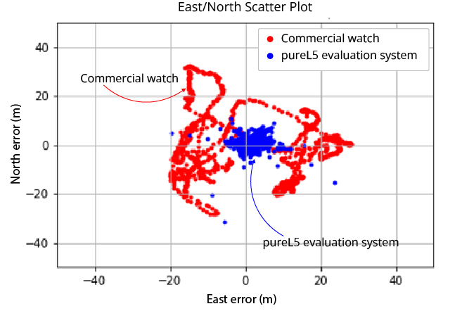
OneNav is sharing side-by-side test results comparing its pureL5 GNSS receiver customer evaluation system to a leading Android smartwatch.
OneNav is a Silicon Valley, California-based technology company designed to power high-performance positioning for location-dependent mobile services.
In a challenging urban environment, oneNav averaged six times better accuracy than the smartwatch. Both units used commercial-wearable antennas for testing. While the oneNav system used only GNSS measurements, the smartwatch GNSS results were augmented by inertial sensors.
At the 95th percentile, the pureL5 unit reported 8-meter accuracy compared to nearly 29-meter accuracy for the smartwatch; pureL5 accuracy includes artificial intelligence/machine learning algorithms that improve the system over time.
“The L5 signal is more accurate and reliable than L1, it has higher power and wider bandwidth, and it is less jammable,” said Steve Poizner, co-founder and CEO of oneNav. “We looked at where the market is heading, with the wearables and tracking device markets exploding and the demand for higher accuracy increasing, and we asked, ‘Why keep two bands/two RF chains/two antennas when you can get superior performance with just L5?’”
The oneNav team comprises top GNSS experts from Qualcomm, Apple, Intel, SnapTrack, SiRF, Trimble and eRide who have decades of GNSS and mobile industry experience. The team has expertise in GNSS system architecture, multipath mitigation, signal processing, ASIC design and AI/machine learning, and collectively has filed more than 300 career GNSS patents.
Investors include Google Ventures, Norwest Venture Partners and GSR Ventures.
InfiniDome has conducted testing and measurements in the Golan Heights along the Israel-Syria border. The goal of the tests was to hunt down jamming events, record them, see how they affect both protected and unprotected receivers, and then compare the results.
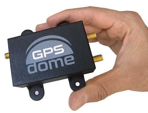
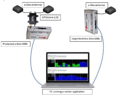
Two identical u-blox M8N receivers aboard a UAV were tested side by side, with one protected by GPSdome technology.
The GPSdome anti-jammer is a retrofit module that can be easily integrated to protect any GNSS-based system. It combines patterns from two omnidirectional antennas to create a null in the direction of the jamming signal, thus attenuating its power, making any GPS receiver about 50 times more resilient to jamming.
In a video of the tests, the GNSS receiver protected by GPSdome can be seen maintaining the GPS signal along the border, enabling uninterrupted navigation.
In contrast, the unprotected GNSS receiver loses the GPS signal during the attack, which can easily result in the drone becoming completely jammed, aggressively drifting and eventually crashing.
The Israel-Syria border experiences frequent jamming from Russian forces positioned in Syria, affecting critical border surveillance operations in the Golan Heights. Other global hotspots for jamming include the U.S.-Mexico border, where drug cartels use jammers on U.S. border surveillance drones, and the Shanghai port in China, where pirates may be the cause of ship and plane navigation confusion through use of jammers.
Jamming in Ukraine has also been well documented, with attacks from Russian forces taking down any plane, drone and even critical infrastructure asset in proximity, according to infiniDome.
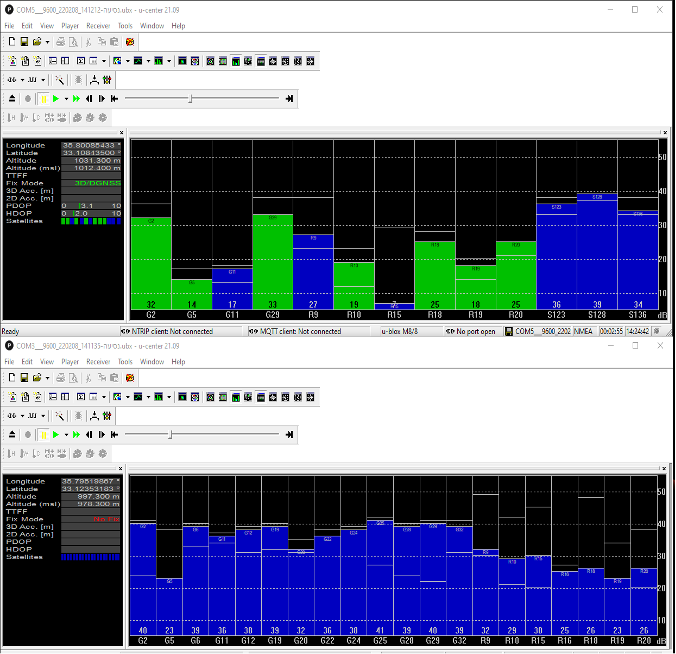
Two screenshots of recordings during the event: The top image is of the GNSS receiver (u-blox M8N) protected with the GPSdome, ensuring continuous navigation. The bottom is unprotected and shows how the M8N was completely blocked for the entire route. (Images: InfiniDome)
The jamming attack was analyzed and appears not to have been a brute force attack, but rather a slightly more sophisticated signal, causing the receivers to “see” satellites but not be able to sync their signals and track them. The receiver protected by the GPSdome was able to distinguish between the real GNSS signals and the jamming signals.
In addition, GPSdome was able to attenuate the jamming signals sufficiently to be able to continue tracking the real GNSS signals while at the same time reporting the attack via its dedicated alert output.
Because GPSdome is both lightweight and easy to integrate (see integration diagram below), it can effectively provide much-needed resilience to drones and UAVs from widely available jammers, enabling drone operators to carry out missions safely and reliably.
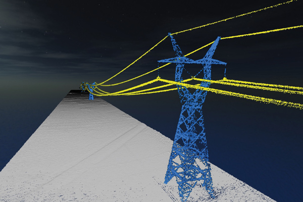
What are the key remaining technical challenges in UAV lidar mapping?
With continuing improvements in UAVs, lidars, GNSS receivers and other sensors, the key to unlocking more efficiency and profitability in this market will be improving and simplifying workflows and processing. The next frontier is integrating AI and machine learning with digital twin models to create forecasting tools.
UAVs are much cheaper to operate than manned aircraft per hour, but not necessarily per square mile. UAVs can cover ground that cannot be mapped from a land vehicle; however, the latter have a much greater range.
You are correct. Each type of vehicle has its area of best utilization. Once we know what the customer wants from the data being collected, we can determine the size, weight and power (SWAP) of the payload needed, and then it’s a matter of analyzing cost versus capability and working with the customer to pick the right payload for the right vehicle at the right price.
What positional accuracy do you achieve for your point clouds?
With our GNSS-receiver-based navigation unit, which also includes an IMU and key IP [intellectual property] from our company, and the right combination of tools, we achieve an accuracy of 2 cm to 3 cm.
What are your key markets for UAV lidar mapping?
I believe it is still the Wild West in this market space. Really smart people are figuring out new ways to use these systems every day. We sell systems to teams doing high-end inspections of infrastructure, such as roads, bridges, corridors and power lines, as well as for land surveying and mining.
What was a recent application of one of your mapping systems?
One of our most recent success stories has been the launch of our Geo-ECTO-1 system. It features dual lidar sensors combined with a 360-degree FOV [field of view] camera and high-end GNSS receiver. It is ruggedized from the ground up and is meant for high-end survey and infrastructure inspection work. The payload is designed to quickly transition to a UAV-based system. Our two launch customers/partners are California-based survey companies Guida Survey and LACO Survey. It has been a great experience getting these systems up and running with our partners.
Our next adventure will be to work with UC San Diego’s Scripps Oceanographic Institute. We are proposing and demonstrating one of these systems to be used for analyzing cliff erosion on the beaches here in California, where several collapses have led to the loss of life. We want to support figuring out how to use the analyses to create a system that would give early warning of trouble spots. With these tools we can make our beaches much safer.
Business Model Enables Mass Adoption of Product with Service
In September 2021, Trimble released its DA2 GNSS receiver with Trimble Catalyst service. I asked Gareth Gibson, the company’s marketing director, Mapping & GIS Solutions, about the product and recent developments in GNSS-enabled mapping.
When I started in this business, more than 20 years ago, we used to divide GNSS receivers into three categories, broadly speaking: consumer grade, resource grade, and survey grade. Are those distinctions still useful?
The survey world and the mapping world have been coming together over the last 20 years or so. Probably Jack Dangermond was one of the first people to publicly acknowledge that. Surveying is an ancient profession whereas mapping and GIS, as an industry, has evolved much more recently. The techniques and the expectations of precision and the complexity of the workflow coming from the survey side has always been somewhat at odds with what the mapping world has been trying to achieve, so the products and the tools of these industries were quite different.
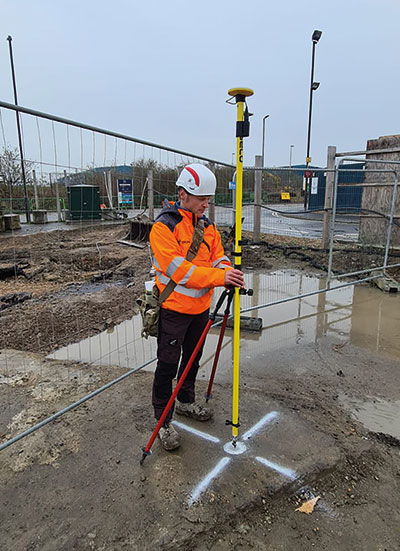
The Trimble DA2 receiver boosts the performance of the Trimble Catalyst GNSS positioning service. (Photo: DroneWorks)
However, there has been a blurring of the lines. Today, the capabilities of mapping-grade GNSS systems are no different from those that can be used in the survey industry as well. Catalyst is an example of that. However, the focus is much more on ensuring that the technology gets out of the way. Let the technology vendor take care of the hard parts, to make it work in the environments where it needs to work, and to make sure it operates with the software that allows the mapping user to focus on the job, with less complexity. We’ve reached that point where it’s difficult to distinguish the capabilities of a survey-grade receiver from those of a mapping-grade receiver. Technically, there’s very little difference.
You can think of Catalyst as renting the performance of the receiver to enable the work to get done. The convergence of technology is enabling the business model transformation, and the business model transformation is aiming to better address the needs of the user. The types of services that these tools enable, the methods with which these tools communicate with homebase and with the vendors—licensing systems, platforms and so forth—have reached a point of enabling delivery of products as a service. That is a good thing because customers are not interested in owning a product as much as they are in getting to the solution that they need.
So, the focus switches from “How do we deliver this product?” to “How do we best deliver this service and the solution?” Catalyst attempts to do that by delivering, in effect, positioning as a service. You are not buying a piece of hardware; you are purchasing the capability to generate and use high accuracy within your workflow to get your job done. That shifts the focus from upfront expense to delivering positioning as an operational cost.
What does the DA2 with Trimble Catalyst service enable that was not previously possible?
It enables the mass deployment of precise GNSS across organizations with tens or hundreds or even thousands of workers. They can now benefit from adding GNSS technology to their work where it was previously prohibitively expensive, too complicated, or simply incompatible with their workflows. Catalyst and the DA2 is enabling that through the business model, which we have employed for the technology, and through the technical capabilities of the platform, which has reached a point of being much easier to be mass adopted across organizations.
The significant change that we’ve made with the DA2 was the addition of support for Apple-based devices. The norm now is to use the phone or the tablet that you have in your pocket, as opposed to purchasing dedicated equipment, especially as it relates to the group of workers we would describe as the location-enabled workforce. These are people typically who are not trained surveyors or GIS professionals but are performing a function with an organization and location-enabled workflows. Software applications are just part of their toolkit for their day-to-day work. It does not make sense to equip these teams with very expensive and complicated equipment, but the functionality that the equipment can provide can unlock some areas of productivity that would have otherwise been inaccessible to them.
What are the remaining technical challenges to mapping for GIS and asset management applications?
The nut that we’ve cracked is enabling precision at almost any practical level, using GNSS, anywhere around the world. We continue to strive towards having access to that level of precision in any environment. There’s a limit to what can be achieved with GNSS alone. So, we start to see more and more the use of combined technologies, different data and sensor fusion. People are leveraging different parts of the technology jigsaw — what is available on their phones, what is available from external sensors, and what they can do with the raw data they are capturing, either directly within a piece of software on their mobile device or somewhere in the cloud, to make better use of the raw information that has been captured.
The second major area is the merging and connecting of workflows, not just the types of data that these organizations are capturing. Organizations are working with field teams, all that data coming together and being able to be used in a toolbox to enable different types of work to get done. In the past, things have been a lot more siloed. Now, technology is enabling us to work together in more clever ways. It is easier to share information.
“The nut we’ve cracked is enabling precision at almost any practical level, using GNSS, anywhere around the world.”
Is accuracy the only difference between surveying and mapping?
For surveyors, the primary deliverable is location. The historical basis of that industry is all about being able to capture and work with information in the most precise way possible. In the mapping world the focus is more on the information that’s being captured about that position, and its precision is just another attribute. That has helped to change our perspective on the relative importance of precision as part of the workflow and has driven us more towards trying to simplify the way that location is captured in a mapping workflow.
Our goal is to capture the most accurate position and to simplify the process for the user. We’ve tried to automate such things as the choice of correction service so that it’s a much more approachable technology and the user can focus on their area of expertise, which is the collection and designation of the mapping attributes.
What are the components of the Trimble Catalyst solution?
There are two elements to Catalyst. One is positioning as a service, enabled through a subscription. The other is the GNSS antenna. The latest generation of that is the DA2. We have made some changes to the DA2 to enable some better functionality and broader applicability. Without a high-quality antenna, there’s only so much that you can do with GNSS. Our focus with DA2 was to make the antenna component of the solution as small and lightweight as possible, but as high performance as possible. We’ve enabled that through a combination of very clever engineering.
The physical structure of the antenna is quite different from that of any other antenna that we build within Trimble. The idea to make it simpler, lighter and lower cost influenced almost every design decision that went into how that antenna is built — from how it fits and mounts with varying carrying solutions to how it is powered. In the first version of Catalyst, we had this notion of running the GNSS receiver as software inside using a computer that was freely accessible and available to every user without needing to burden the antenna itself and create a smart antenna. We said, “Well, if we can deliver GNSS by software, let’s leverage the computing power of the user’s phone or tablet.” So, we took the Catalyst GNSS receiver engine and ran it as an app on a phone.
The Trimble DA2 receiver at work. (Photo: Trimble)
There were some limitations with that approach. We needed to have a fully cabled solution between the antenna and the phone to enable the required bandwidth from the antenna to the software itself, which required a USB connection and put a fairly heavy computational burden on the phone. However, that enabled us to strip out a lot of the excess weight and complexity from the antenna design, which lowered the cost of the antenna. It was a trade-off decision.
With the DA2 we’re acknowledging those changes, plus the limitations that are imposed by wanting to be compatible with the Apple environment of devices. We can still create a very low cost and lightweight computing package to run this same engine in software, but just move that computing resource back into the antenna again. So, it’s still a software defined receiver—effectively a completely different technology from what you would find on a typical hardware receiver.
We have added a wireless radio to allow GNSS positions to be communicated back to your phone or your tablet via Bluetooth. So, DA2 is a lot more versatile because it enables iOS device usage and wireless transfer information from the antenna to the phone or tablet.
Now, how do you make that work as a package to deliver high-precision results? You need access to correction services and a definition of how you want the receiver to behave based on a business model of what consumers are charged. That’s where the subscription component of the Catalyst service comes in. With Catalyst, we want to simplify the way that customers choose what they want and how they get it.
So, rather than purchasing a specific hardware configuration, figuring out what correction services to use, and how to configure them, you simply subscribe to whatever your required performance level is, and Trimble handles the rest. Each subscription is time-based, so it could be annual, monthly, or even hourly. It is a completely managed system that works everywhere in the world.
What are the options for receiving the corrections?
The DA2 supports delivery of corrections over the internet or through the antenna itself — so, in an offline or an online environment. Catalyst uses Trimble’s dedicated correction services, so Trimble VRS Now, which is available in parts of North America and most of Western Europe, as well as Trimble RTX, which is available everywhere in the world and is also delivered by internet or by satellite L band. Globally or regionally available augmentation systems such as EGNOS and WAAS, and those smaller systems for DGPS-type positions, are also used where it’s necessary as a fallback option.
The receiver will choose what correction service it needs to use based on the user’s subscription level and the environment in which the receiver is currently operating. It knows where in the world it is and which license type the user has, so it will try to use the best available source without the user needing to really think about it. The user just specifies to which precision level they want to subscribe — such as one centimeter or 10 centimeters — and the receiver figures out the rest. Catalyst also supports those customers who have their own correction services and want to use it. In most cases, however, that’s not necessary.
Does the current version of Trimble Catalyst differ from the previous version in any other way?
With the latest generation of Catalyst you no longer need a high-end phone to run the service because we have removed the reliance on USB to deliver the data from the antenna to the controlling device. Now, you can effectively do all the computation in the antenna and use Bluetooth for data transfer, which makes it a bit more versatile. Additionally, we have introduced a handle that allows you to use the DA2 in a handheld format that also stores a battery pack.
The biggest leap was certainly the addition of iOS support. After releasing the DA1, we quickly realized that it was not addressing your needs if you were not an Android user it. In North America, more than 70% of business organizations prefer Apple to Android. So, this improvement has more than doubled our addressable customer base. It’s also for those mixed fleet organizations that did not adopt Catalyst because they did not want to have one solution for their Android users and a different one for their iOS users.
What markets and applications are you targeting with it?
We’ve been pleasantly surprised by the response to DA2 and the types of customers that we are seeing. We define our customers in four buckets. One consists of small, independent, non-geospatial businesses, which is a new area for us—the geospatially enabled workforce, people who are using applications that have a location component, who previously would not have been able to justify the purchase of dedicated and expensive equipment. In this bucket I would put landscape gardeners for example, or golf course designers or people who now can create a map much more easily and effectively.
Another consists of consultants and contractors. These are organizations small and large doing geospatial contract work. They are specialists who get sent out into the field to either do mass data collection projects or to consult and provide professional services with a geospatial bent. These are much more traditional customers; they know a little bit more about the technology and what they’re doing. For these customers, Catalyst is a new tool. It enables them to deploy GNSS more broadly across their organizations.
Then there are the sort of organizations and businesses that run their own teams and perhaps have their own GIS department and a field crew dedicated to operating and maintaining the GIS. But they also have the field operations groups, who aren’t geospatially savvy or aren’t geospatial professionals. They’re starting to deploy GNSS across their teams more effectively, as well, because Catalyst is the type of tool that you can keep in the glove box of your car and have available to use at a moment’s notice. So, utilities, municipalities, public works organizations and the like, large federal government agencies in the United States especially.
Finally, the owners of large infrastructure assets, privately owned organizations running ports or oil and gas operations. Again, this is an attractive solution for them. We’re finding that this solution will enable us to address the full range of the market much more effectively.
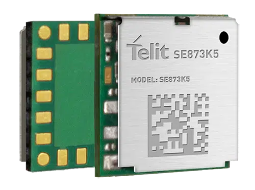
Telit has released the SE873K5 multi-constellation GNSS receiver in the L1 band. The SE873K5 simultaneously tracks and navigates all four GNSS constellations — GPS, Galileo, GLONASS and BeiDou — providing GNSS information over a UART, I2C or SPI interface serial port using the NMEA protocol.
Based on the AG3335 system-in-package from Airoha, the SE873K5 is the latest addition to Telit’s SE873 family of modules and the natural migration path from SE873 and SE873Q5.
The module is a 7mm x 7mm x 2.25mm QFN-like semiconductor package with embedded SPI flash, RTC and TCXO. With its compact size, the latest generation chipset and the advanced power modes, the SE873K5 has the benefits of low cost, small form factor and good electrical and thermal performance — suitable for wearables, fleet tracking, drones and more.
The SE873K5 low-power processing core delivers customizable power-saving modes. It optimizes current draw at module wake-up by supporting both local- and server-based assisted GNSS (A-GNSS) for improved time to first fix, while satellite-based augmentation system (SBAS) corrections from WAAS, EGNOS, MSAS or GAGAN increase positioning accuracy.
The internal flash memory allows firmware updates and customization, as well as ephemeris predictions storage.
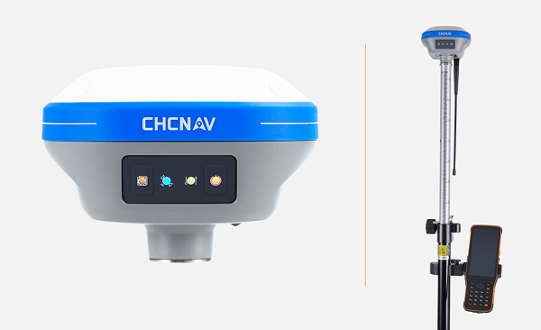
CHC Navigation (CHCNAV) has launched the i73+ pocket-sized GNSS receiver. The i73+ is a compact, powerful and versatile receiver with an integrated UHF modem that can be used either as a base station or rover. Powered by 624 GNSS channels and the latest iStar technology, the i73+ delivers survey-grade accuracy in all jobsite configurations.
“Building on the legacy of the i73 GNSS receiver, the new i73+ receiver is designed to maintain its proven compact and lightweight concept, but adds the ability to be operated as either an RTK base station or a rover,” said Rachel Wang, product manager, Surveying and Engineering Division, CHCNAV. “To enable this extra feature, we have built in the latest UHF modem technology, allowing the reception and transmission of RTK corrections without sacrificing receiver size and power consumption.”
Integrated Tx/Rx UHF modem extends capacity
The i73+ has a built-in transceiver radio module compatible with major radio protocols, making it a suitable portable built-in UHF base and rover kit with fewer accessories. The i73+ is a highly productive NTRIP rover when used with a handheld controller or tablet and connected to a GNSS RTK network via CHCNAV LandStar field software.
The integrated, advanced 624-channel GNSS technology takes advantage of GPS, GLONASS, Galileo and BeiDou, in particular the latest BeiDou 3 signal, and provides robust data quality at all times. The i73+ extends GNSS surveying capabilities while maintaining centimeter-level survey-grade accuracy.
The i73+ GNSS receiver. (Photo: CHCNAV)
Built-in IMU technology
With its inertial measurement unit (IMU) compensation ready in 3 seconds, the i73+ delivers 3-cm accuracy at up to 30º pole tilt, increasing point measurement efficiency by 20% and stakeout by 30%. Surveyors are able to extend their working boundary near trees, walls and buildings without the use of a total station or offset measurement tools.
The i73+ is the lightest and smallest receiver in its class, weighing only 0.73 kg including battery. It is almost 40% lighter than traditional GNSS receivers and easy to carry, use and operate without fatigue. The i73+ is packed with advanced technology, fits in hands and offers high productivity for GNSS surveys.
The i73+ includes a built-in UHF modem. (Photo: CHCNAV)
The housed AsteRx-U3 Marine and the OEM board AsteRx-m3 Fg are the two new GNSS receivers for dredging, marine construction and offshore applications
Photo: CharlieChesvick/E+/Getty Images
Septentrio, a leader in high-precision GNSS positioning solutions, has launched two new GNSS products for marine applications: AsteRx-U3 Marine and AsteRx-m3 Fg.
Both products offer accurate positioning near shore and offshore via centimeter-level real-time kinematic (RTK) or the built-in Fugro precise point positioning (PPP) sub-decimeter subscription service, delivered either over NTRIP internet or over L-band satellite.
Corrections delivered over L-band allow dredging, bathymetry or marine construction projects even in areas where there is no internet service. The AsteRx-U3 Marine receiver, enclosed in an IP68-rated housing, offers a unique feature of a dedicated L-band demodulator with a separate L-band RF input, which allows for the use of dedicated antennas for excellent reception of L-band signals even at high latitudes.
“The new products are designed around our most powerful GNSS core, bringing the latest evolution in GNSS technology to the demanding marine construction and dredging markets,” said Silviu Taujan, product manager at Septentrio. “They build on the success of the field-proven AsteRx-U Marine Fg and AsteRx4-Fg, with more processing power to allow tracking of all visible satellite signals while enabling higher update rates. AsteRx-U3 Marine and AsteRx-m3 Fg are both feature-rich receivers, combining the best-in-class RTK base and rover functionality with an option of sub-decimeter PPP positioning.”
Orders for both products can be placed immediately. Deliveries for AsteRx-m3 Fg will follow the company’s standard lead times, while deliveries for AsteRx-U3 Marine will start from July.
Septentrio GNSS technology is resilient to RF interference, which on vessels can come from satellite uplinks such as Iridium modems or from other radio antennas. Having robust GNSS technology means accurate and uninterrupted positioning on any vessel, even in challenging marine environments. Both AsteRx-U3 Marine and AsteRx-m3 Fg receivers offer accurate heading and pitch or heading and roll orientation information with the dual GNSS antenna configuration.
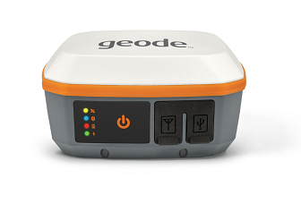
Juniper Systems has introduced the Geode GNS3 GNSS receiver, which allows users to collect real-time GNSS data with sub-meter, sub-foot and decimeter accuracy options.
With a scalable platform, users can purchase the level of accuracy they need now, while having the option to increase accuracy in the future.
“This new Geode offers expanded accuracy options to our users,” said John Florio, Geode product manager at Juniper Systems. “We set out to deliver a product that is scalable to our user’s needs. The GNS3 allows users to purchase a receiver that fits their accuracy needs at the moment, while still being able to unlock greater accuracy through subscriptions when that need arises.”
Photo: Juniper Systems
Available in both single-frequency and upgradable multi-frequency antenna configurations, users have the level of accuracy needed to get the job done. The Geode GNS3S offers superb sub-meter accuracy with a single-frequency antenna. The GNS3M allows for scalable accuracy; its multi-frequency antenna support all constellations on L1, L2 and L5 frequencies.
Multi-frequency signal tracking, together with Atlas L-band correction subscriptions, allow for up to decimeter accuracy. As with previous Geode devices, SBAS corrections are available for sub-meter accuracy in certain regions.
Both models also support local differential GNSS real-time kinematic (RTK) and continuously operating reference networks (CORS) through the Geode Connect NTRIP client.
“Providing Atlas corrections and scalable accuracy allows for the Geode to be used in new markets,” Florio said. “A few of these include water utility locating, agriculture and irrigation mapping, mapping projects in remote locations where other correction services are not available, and any other mapping need that requires a higher degree of accuracy.”
The Geode GNS3 offers flexible connectivity and can be used with Windows, Android, iPhone and iPad devices. A USB-C port allows for data transfer and fast charging and an antenna port allows for the use of an external antenna.
The Geode GNS3 GNSS receiver is now available worldwide.
New offerings will deliver accurate navigation to industrial applications even in areas where GPS is unavailable
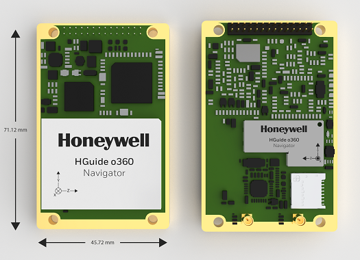
The HGuide o360 Navigator. (Photo: Honeywell)
Honeywell has expanded its HGuide industrial navigation portfolio with three new technologically advanced navigation systems — the HGuide o360 INS/GNSS navigator, HGuide n500 inertial navigator and the HGuide g080 GNSS receiver.
The new HGuide products are designed for a wide array of industrial and autonomous applications across air, land and sea vehicles and related equipment.
The HGuide o360 navigationsystem is a compact single-card, all-attitude inertial navigation system (INS) GNSS navigator that can deliver an accurate and robust position and attitude navigation service, even through GNSS-challenged or denied environments, to industrial and autonomous applications. It provides the features and compatibility needed for a simple integration.
“The HGuide o360 is an engineering marvel and a technological breakthrough. There are no similar competing products in the industry today that can achieve such a high-performance level at this price point and size,” said Matt Picchetti, vice president and general manager, Navigation & Sensors, Honeywell Aerospace. “The entire HGuide product line is suitable for a wide range of industries, including autonomous vehicles, marine and a host of industrial applications where accurate positioning and attitude information is required in real time.”
The HGuide o360 INS/GNSS navigator contains a powerful dual antenna, multi-frequency, multi-constellation, real-time kinematic (RTK) GNSS receiver, Honeywell’s i300 inertial measurement unit (IMU) technology, and a high-grade calibrated magnetometer.
The HGuide o360 is designed for platforms that require high-performance navigation data in an ultra-low size, weight and power (SWAP) package.
The HGuide n500 inertial navigator is a navigation-grade bring-your-own-GNSS all-attitude navigator that supports continuous position and attitude navigation even during prolonged GNSS outages. The HGuide n500 is built on Honeywell’s HG4930 IMU plus the Honeywell HGuide Sensor Fusion software.
The HGuide g080 GNSS receiver is a dual-antenna, triple-radio frequency, all-constellation GNSS receiver that delivers heading and positioning down to sub-centimeter levels even in GNSS-challenged environments. It includes an onboard IMU to allow tracking during short GNSS outages and enable smooth and fast reacquisition. The product is available with or without RTK functionality.
Inertial navigation systems are highly critical in navigation and comprise an IMU, a GNSS receiver and sensor fusion software. These components work together to calculate position, orientation and velocity to deliver critical navigation information in GNSS-denied areas such as urban canyons, bridges, tunnels, mountains, parking garages and dense forests.
Bad Elf has introduced a base/rover feature built upon its Bad Elf Flex GNSS receiver. The new base/rover feature brings affordable centimeter-level accuracy to surveyors and geospatial professionals working anywhere in the world.
The solution consists of two Flex GNSS receivers and two UHF radios, allowing customers to perform high-accuracy field data collection in areas where traditional real-time kinematic (RTK) corrections or cellular coverage is not available. Existing Flex customers can upgrade by adding Flex radio kits.
Bad Elf designed the base/rover feature with emphasis on accuracy, affordability and versatility. The Bad Elf Flex enables reliable data collection either as a standalone receiver or paired with apps on iOS or Android phones and tablets. A checklist-based workflow ensures consistent results and eliminates many common issues associated with setup and deployment of a base/rover solution.
Photo: Bad Elf
“The Bad Elf app walks the user through these steps and more, and it doesn’t let the project proceed until each checklist is complete,” said Larry Fox, vice president of Marketing and Business Development at Bad Elf. “The automated checklists simplify every process, so that geospatial professionals and surveyors of every experience level get reliable results.”
The base feature requires only one Flex Extreme and a radio kit. Customers may choose to use either Standard or Extreme Flex with a radio kit for rovers. Using Flex Standard and one daily token provides access to the rover feature.
Bad Elf’s flexible hardware-as-a-service model provides a mechanism for customers to further reduce the capital cost of a complete base/rover system. In addition, customers can deploy multiple rovers in either configuration for larger projects.
“For about one-third of the purchase price of competing products available today, our base/rover feature makes survey-grade one-centimeter accuracy a reality worldwide,” said Fox. “And our pay-as-you-go Flex Token model dramatically reduces operating expenses by allowing users to activate — and pay for — just the service levels needed on a given day.”
Complete base/rover kits are available immediately, along with à la carte options for existing Flex customers. The Flex base/rover solution is compliant with FCC operating standards in the United States. Bad Elf provides customers with complete instructions for acquiring a radio operator license and call-sign designation.
Both lightweight, compact airborne laser scanners are easily installed on various UAV platforms or small survey aircraft and helicopters. They are adapted to high-density point corridor mapping applications, day or night, under leaf-on and leaf-off conditions or with dense vegetation to provide reliable results.
“Nowadays, it is critical to obtain the highest data quality for the majority of aerial survey projects,” said Andrei Gorb, product manager of CHC Navigation’s Mapping and Geospatial Division.
Combining with industrial-grade GNSS receivers and high-precision inertial measurement units (IMUs), the AA1400 and AA2400 provide 2 to 5 cm survey-grade accuracy. They also integrate Riegl’s VUX lidars with waveform-lidar technology, allowing echo digitization and online waveform processing.
“Multi-target resolution is the basis for penetrating even dense foliage,” Gorb said. “The continuously rotating polygonal mirror wheel enables scanning speed of up to 400 lines per second, allowing for effective coverage of large areas when used from fast drones or aircraft.”
The BB4 UAV equipped with the AA2400 scanner for the city mapping task. (Photo: CHCNAV)
Their built-in premium Riegl VUX-120 and VUX-240 lidar sensors feature a high-speed data acquisition rate of up to 1.8 MHz and a scan speed up to 400 lines per second. This provides a linear accuracy of 1cm to 2 cm on long-range scanning, suitable for fixed-wing UAV corridor mapping.
CHCNAV offers several external cameras for add-ons to the AlphaAir. Setups can include nadir or nadir and oblique cameras from Sony or PhaseOne. By obtaining high-resolution geo-referenced and oblique imagery, more applications can be supported, increasing the return on investment for the client.
The scanning results of the AA1400 and 2400 lidar series. (Photo: CHCNAV)
The one-click connection of the AlphaPort to the power source and camera makes the installation of the AA1400 and AA2400 quick and easy, eliminating the need for additional accessories and time for camera calibration. The AA1400 and AA2400 reduce the risk of cable damage caused by aircraft vibration and acceleration during takeoff and landing.
CHCNAV provides a full range of solutions that allows a complete lidar solution to be added to the users’ geomatic services. The software suite includes CoCapture UAV field application for fully automated reality capture and real-time mission tracking, and the CoPre desktop software for semi-automated point cloud processing.
The AA1400 and AA2400 lidar series solutions are available worldwide today through the CHCNAV distribution network.
A module for SurvCE version 6 software enables surveying with mixed brands of GNSS receivers and total stations. SurvCE is a data-collection software package from Carlson Software. SurvPC Hybrid + provides driver support for numerous devices, allowing the surveyor to interface with both types.
Features of SurvPC Hybrid+ include:
Follow Me. An alternative to optical tracking, Follow Me continuously turns the total station towards the prism using the location as determined using GNSS. This eliminates stray reflectors and lengthy searches.
Smart Lock. The software will automatically detect when a user is slowing to take a measurement and lock on the prism so that it’s ready to go.
Smart Staking. With smart staking, it will no longer be necessary to maintain optical tracking during stakeout. Stakeout directions are kept fresh using the GNSS receiver as the surveyor approaches a stakeout point. When close to the point, the total station will automatically turn and lock on the prism for the final staking precision needed.
Cross Check. SurvCE will automatically cross-check the total station and positions determined using GNSS and warn the surveyor when they differ.
Backup Tracking. With backup tracking, SurvCE will automatically show the position determined using GNSS on the map when the total station isn’t locked.
Hybrid-Resection. Easy hybrid-resection allows for setup anywhere using positions determined using GNSS to calculate the total station occupied point and orientation. Measurements from the GPS and total station are time-synchronized for an accurate and simple one-tap resection measurement.
Auto-Localize. Simplify setup by seamlessly auto-localizing the GPS receiver as total-station points are stored.
Easy Setup Wizard. The easy setup wizard walks users through setup using auto-localization, hybrid resection or hybrid localization, then finishes with a cross-check for quick project start.