Flanders uses Septentrio receivers to guide automated blasthole drills, such as at this South African mine run by AngloGold Ashanti. Photo: Anglogold Ashanti/Flanders
Flanders, a U.S.-based company with expertise in electrical machinery and control systems, has developed its proprietary ARDVARC advanced drill-rig control system to control mine-drilling machines, making them safer and more efficient. The drill rigs equipped with ARDVARC create holes with centimeter precision. This ensures optimal rock fragmentation, simplifying and expediting subsequent jobs such as stone extraction and removal.
Mines close to the poles or to the magnetic equator, such as those in the Amazon, are challenging for GNSS receivers because they tend to experience the most intense ionospheric scintillations, resulting from rapid fluctuations in the electron density in the ionosphere. These scintillations affect GNSS signals that travel from space to Earth, causing degradation of positioning accuracy or even positioning loss.
To address this challenge, ARDVARC uses Septentrio AsteRx-U GNSS receivers. They are housed in a tough IP67 enclosure and run Septentrio’s proprietary GNSS+ algorithms including IONO+, which ensures high-accuracy positioning even during ionospheric scintillations.
ARDVARC’s benefits include a faster drill cycle time, increased drill hole location precision, increased drill-rig component operating life, improved fragmentation and greater operator safety. The system is available in several levels.
The Intelli-rig manual control system also delivers data on the position of each blast hole, the machine operation and the drilling conditions; it incorporates mine-planning functionality using the mine’s existing or Flanders’ optional GPS equipment.
One-touch converts a manually operated machine to one operated with a single touch, increasing productivity. Once the machine operator positions the drill rig over the desired target, One-touch initiates the automated drilling process, which includes machine leveling, hole collaring, drilling to elevation and angle, rod handling, bit retraction and jack reset.
The fully autonomous drilling solution removes the operator from the cab, allowing one operator to monitor multiple drilling operations from a safe distance. The solution increases productivity by enabling drilling during blasting and shift changes. It uses Flanders’ HazCam to monitor the surroundings, preventing the drill from operating in unsafe conditions.
A SolarCleano F1A robot tackles a tough cleaning challenge on a solar farm in Saudi Arabia. (Photo: SolarCleano)
SolarCleano, based in Garnich, Luxembourg, makes robots that clean large solar panel installations using GNSS receivers and corrections from Swift Navigation. We asked Christophe Timmermans, SolarCleano’s managing director, a few questions about its technology.
How often do solar panels need to be cleaned?
For decades, it was believed that solar panels did not need to be cleaned due to their angle to the ground and rain. Nowadays, however, the cleaning of solar panels is widely accepted as necessary to optimize a plant’s return on investment (ROI).
How much time per sq. meter do your machines take to clean solar panels?
To provide the fastest possible ROI to our customers, we developed a range of robots to best address the needs of various solar plant layouts. A large utility-scale project with high level of soiling losses in a desert environment will need a very fast and reactive cleaning solution such as our SolarBridge B1, which can clean 24/7/365 fully autonomously. The most suitable solution for a farm rooftop in Germany that needs to be cleaned three to four times a year might be our F1 model, which can clean the equivalent of up to two soccer fields a day. It is designed for rooftops, floating panels and mid-size plants up to 50 MW. While the speed of cleaning is a very important variable, the quality of cleaning is often considered as the driver to performance, which is why we propose different types of brushes depending on the soiling types. Plus, the robot speed can be modified according to the soiling level.
Why do robots need GNSS receivers to clean solar panels?
Moving on inclined, wet glass surfaces makes odometry unreliable because robots might occasionally slip. Therefore, GNSS is the most reliable way to continuously monitor their exact position. Our robots also need path planning because they cannot operate randomly like lawn mowers. Safety is obviously a major concern; we need a very high localization accuracy to ensure that robots don’t fall off the panels. Finally, the largest solar plants are developed in dry, remote locations with high irradiation such as the Sahara, Atacama and Australian deserts. GNSS allows us to have very accurate localization even in those remote areas. In addition, this solution can easily be installed on already-existing solar plants with little capital expenditure.
What spatial accuracy requirements do the robots have for this task?
Safety is our absolute priority. Therefore, our robots need an accuracy of less than 3 cm. They also need to be aware, in real time, of changes in their surroundings, such as maintenance teams, animals and uneven ground.
On large solar farms, GNSS receivers always have a clear line of sight to the satellites and do not suffer from multipath. So, what are the key technical challenges?
Our robots have the additional advantage that they do not need to drive very fast. However, we need to manage fleets of robots on the other side of the world in regions difficult to access and with harsh weather conditions, such as very high or low temperatures and the accumulation of dust behind panels due to air vortices. We need to be able to perform remote maintenance and solve any issue from our control center in Luxembourg. These challenges make our robots increasingly robust. With a current fleet of more than 300 robots around the world, we collect lessons every day to ensure a greater reliability for our upcoming generations of robots.
Why did you choose to partner with Swift Navigation?
We share a vision with Swift: “Accessible automated solutions serving sustainable goals.” We also share other important values, such as “iterate quickly” and “focus on what matters.”
A mining road-train loaded with ore passes through an outback town. A Hexagon system will guide autonomous movement of similar heavy vehicles. Photo: BeyondImages/iStock/Getty Images Plus/Getty Images
Hexagon’s Autonomy & Positioning and Mining divisions recently partnered with Mineral Resources Limited (MRL), a mining services company, to develop an automated road-train solution for deployment on MRL’s haulage fleet over the next two years. The solution integrates drive-by-wire technology with an autonomous management system to orchestrate vehicle movement in road-train haulage to improve safety, productivity and sustainability. We asked Lee Baldwin, the director of Hexagon’s Autonomy & Positioning division, a few questions about the system.
What does an automated road-train do?
It is for haulage on roads hundreds of kilometers long. It first will be used to move ore from a mine processing facility in the Pilbara region of Western Australia, about 1,200 kilometers north of Perth, to Port Hedland, where it is loaded on ships bound for Asia for use in steel mills. Typically, this is done using either rail or a road train, which is a highway truck pulling multiple trailers. Today, a person drives a road train.
What motivated this project?
Mines have difficulty finding drivers for mining trucks and road trains because the mines are very far away from the nearest city, Perth, so they must fly workers in and out, which is very costly. Many of them are on 10-day shifts. Also, there are safety concerns.
How does an automated road-train work?
It requires three typical subsystems that you would have on any autonomous vehicle. The first one is positioning, including redundant GNSS receivers with our TerraStar correction services. The second is a perception system for collision avoidance, using our HxGN MineProtect Collision Avoidance System. The third one is route planning. We will start by platooning, with a driver in the first truck, which will be followed by three unmanned ones, each towing multiple trailers. Each truck will have the positioning, perception and route-planning systems. Later, we will achieve full autonomy by removing the driver from the lead vehicle.
How will the transfer at the mine work?
At a mine site, the road train will be commissioned in a sequestered area, then sent to a loading area where it will be loaded with ore, either automatically or by a manned wheel loader. Next, it will travel 200 kilometers to the port, where it will dump the ore. Finally, it will be decommissioned and queued up for the return journey.
Which parts are already in place and which ones are still being developed?
At Hexagon, we are already putting technology in manned mines. For example, we already have the collision-avoidance system, a fleet management system, and some sitewide planning systems. However, the trucks that the customers are choosing will have to be converted to be drive-by-wire to accommodate our autonomy system. They will use two PwrPak7 GNSS receivers and the TerraStar correction service.
Farmers rely on their GNSS receivers to keep their machines on track, their maps accurate, and their rows straight in demanding environments. GNSS receivers on agricultural equipment need to continue to perform at a high level when faced with extreme weather, temperature and vibration while navigating varying terrain. In addition, farmers rely on the correction services that provide them with the high accuracy needed to keep them operating. Still, they face challenges with outages and interruptions from obstacles blocking satellite signals.
Hexagon | NovAtel’s SMART7 GNSS receiver and TerraStar Correction Services together create an accurate, robust and reliable solution for farmers. These products undergo extensive testing to ensure a high-performing and dependable solution. The SMART7 accesses all four GNSS constellations (GPS, GLONASS, BeiDou and Galileo), providing the best availability in variable terrain and environmental conditions. To compensate for the pitch and roll in the field, the receiver includes terrain compensation — keeping farmers at centimeter-level accuracy when using TerraStar-C PRO, TerraStar-X or RTK corrections.
Photo: Hexagon | Novatel
TerraStar Correction Services are based on a global network of advanced and proprietary GNSS control centers to ensure 99.999% signal availability to farmers. By delivering quality satellite corrections without the need for base stations, farmers can get the accuracy needed for their operations in a scalable format that moves with their equipment.
Jacob Van Den Borne is a potato farmer in the southern region of the Netherlands. He has been working with precision farming for more than 10 years and recently switched his Fendt tractor to NovAtel’s SMART7. Throughout his last season, Jacob noticed a substantial improvement in signal reception while passing along the edges of his heavily treed field. Previously, his GNSS equipment would lose reception, causing his rows to wander. After using a SMART7 for one season and experiencing its high precision and reliability, Van Den Borne plans to switch all receivers on his farm to the SMART7.
Evolving advanced driver-assistance systems (ADAS) and developing safe perception and positioning systems in the agriculture industry are top priorities for NovAtel. With the challenges faced by farmers, finding new ways to support a sustainable increase in their production and productivity will help ease the pressures of a growing population.
A roundup of recent products in the GNSS and inertial positioning industry from the January 2022 issue of GPS World magazine.
Surveying
Base Station
Receives all available GNSS signals
Photo: Trimble
The Trimble R750 GNSS modular receiver is a connected base station for use in civil construction, geospatial and agricultural applications. The R750 provides high-accuracy base-station performance, giving contractors, surveyors and farmers more reliable and precise positioning in the field. The R750 also can be used to broadcast real-time kinematic (RTK) corrections for a wide range of applications, including seismic surveying, monitoring, civil construction, precision agriculture and more. Access to all available satellite signals provides improved performance and reliability when used with a Trimble ProPoint GNSS rover. ProPoint gives users improved performance in challenging GNSS conditions, with improved signal management.
Trimble, trimble.com
Flight Planning
Updated for safer UAV surveying
Photo: Microdrones
The mdCockpit app was designed for professional drone users to make it easy to plan, monitor, change and control flights from an Android tablet. The updates in version 2021.3 include features that improve flight safety and give more options for surveying with an aim to deliver a premier solution for planning, monitoring, adjusting, analyzing and controlling professional drone flight missions from a tablet. Updates include an improved flight editor, flight data collection and drone configuration. Drone pilots can download mdCockpit through the Google Play store.
Microdrones, microdrones.com
OEM
LTE Module
With 2G fallback for Latin America
Photo: Telit
The LE910S1-ELG LTE Cat 1 module is designed for internet of things (IoT) applications in Latin America that need a combination of performance, affordability and voice support in a compact form factor. It provides 2G fallback, making it suitable for areas that have not upgraded to 4G. With an embedded GNSS receiver, the cost-optimized LE910S1-ELG is suitable for tracking applications such as fleet management, stolen-vehicle tracking and recovery, and other mobile IoT applications that need to maintain a reliable connection when moving around in a country, region or multiple regions. The power-saving embedded GNSS receiver enables the use of GNSS positioning even when the cellular modem is switched off.
Telit, telit.com
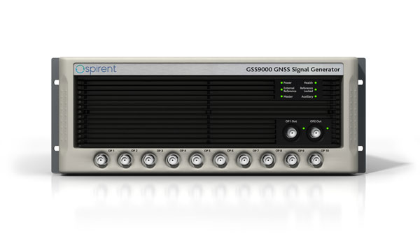
Flex Power
Capability now on constellation simulator
Photo: Spirent
A new positioning, navigation and timing (PNT) test capability commonly referred to as programmable power — or flex power — is available on the Spirent GSS9000 constellation simulator and can be applied to existing scenarios. Flex power is the reallocation of transmit power among individual signals in GPS satellites, providing a countermeasure against GPS jamming. Spirent simulators fully support programmable power for M-code, Y-code and C/A (coarse acquisition) code.
Spirent, spirent.com
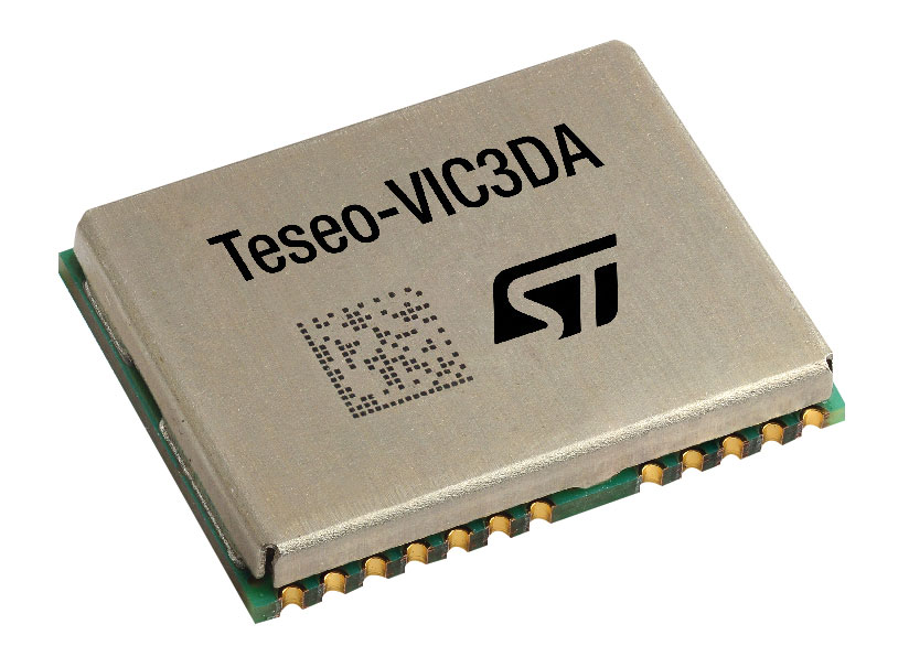
GNSS Module
Automotive qualified with INS and dead reckoning
Photo: STMicroelectronics
The Teseo-VIC3DA is the latest member of the Teseo module family, designed for vehicle positioning. It combines the Teseo III GNSS integrated circuit with the 6-axis MEMS inertial measurement unit (IMU) and dead-reckoning software to provide super-high-resolution motion tracking for advanced vehicle navigation and telematics applications. Teseo III offers robust positioning capabilities by simultaneously receiving signals from GPS, Galileo, GLONASS, BeiDou and QZSS constellations. The module enables competitively priced in-car navigation, fleet management and insurance-monitoring applications.
STMicroelectronics, st.com
PNT Platform
Protects critical infrastructure from GNSS vulnerabilities
Photo: ADVA
The scalable aPNT+ platform meets the latest guidelines for resilient positioning, navigation and timing (PNT), providing end-to-end control and timing network visibility for robust protection against the catastrophic risks that PNT disruption poses to national security and essential assets such as power grids. Even without GPS or GNSS timing, the solution provides an intelligent, end-to-end self-recovery system designed around a three-fold framework, integrating multi-layer detection, multi-source backup and multi-level fault-tolerant mitigation.
ADVA, adva.com
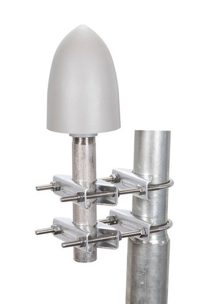
Timing Antennas
IP67-compliant for outdoor and marine environments
Photo: RadioWaves
A new series of GPS/GNSS timing antennas cover the L1 and L5 GPS bands, providing axial ratio and higher accuracy for the reception of satellite timing signals and reference frequencies for enhanced phase synchronization in precision network deployments. Their high gain, low noise figure of 2-dB and high out-of-band rejection allows for use of longer and cost-effective cables for easy and flexible installations. Built-in surge protection supports a wide range of GNSS including GPS, GLONASS, BeiDou and Galileo, as well as Iridium.
RadioWaves, radiowaves.com
Mapping
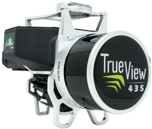
Imaging System
Designed for utility and infrastructure mapping
Photo: Geocue
True View 435 is an economical platform for utility-grade mapping, with superior ground-capturing capabilities for lightly vegetated areas. The next-generation compact 3D imaging system has the sensitivity needed for infrastructure mapping. Its position and orientation system is the Applanix APX-15, achieving accuracy of better than 5 cm RMSE and precision of better than 5 cm at 1 sigma.
GeoCue, geocue.com
Long-Range Scanner
Includes integrated GNSS receiver
Photo: Riegl
The VZ-2000i long-range 3D laser scanning system combines user friendliness with fast, accurate data acquisition. The flexible system includes an integrated GNSS unit for a high-accuracy real-time kinematic (RTK) solution. Other peripherals and accessories include a SIM card slot for 3G/4G LTE, WLAN, LAN, USB and other ports. A new processing architecture enables execution of different background tasks onboard in parallel to the simultaneous acquisition of scan data and image data, such as point-cloud registration, georeferencing and orientation via an integrated inertial measurement unit.
RIEGL, riegl.com
Transportation
Vehicle Antennas
Designed for Intelligent connected cars and trucks
Photo: Harxon
Two new GNSS antennas are designed for vehicles equipped with advanced sensors, controllers, actuators and other devices. They are enabled for intelligent information exchanges between the vehicle and everything (V2X), connecting autos with GNSS, 5G, Wi-Fi, ultra-wideband and more. The integrated antennas support dedicated short-range (DSRC) and cellular vehicle-to-everything (C-V2X) communication, embedding a premium GNSS antenna with high gain for consistent and reliable precise positioning service. They also allow for multiple input and output of data to achieve swift internet download speed in 5G networks.
Harxon, harxon.com
NVIDIA AV Support
Receiver now supported on autonomous platform
Photo: NovAtel
The PwrPak7-E1 GNSS receiver is now supported on the NVIDIA Drive Hyperion autonomous vehicle (AV) development platform. Selected for its robustness and precise position output, the PwrPak7-E1 will be offered with NVIDIA’s autonomous driving test fleets worldwide. Drive Hyperion is a fully operational, production-validated and open AV platform that reduces the time and cost required to outfit vehicles with autonomous driving and artificial intelligence (AI) features. The PwrPak7-E1 also is now compatible with NVIDIA’s DriveWorks v4 software release.
Hexagon | NovAtel, novatel.com
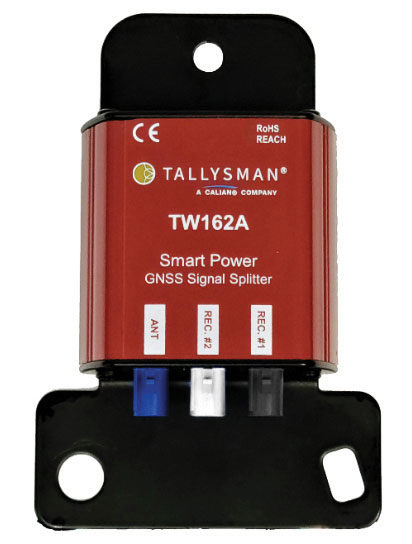
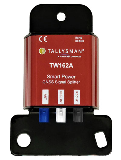
Splitter
Provides signals to two GNSS receivers
Photo: Tallysman
The TW162A automotive-grade smart power GNSS signal splitter supports the full GNSS spectrum: GPS/QZSS-L1/L2/L5, QZSS-L6, GLONASS-G1/G2/G3, Galileo-E1/E5a/E5b/E6, BeiDou-B1/B2/B2a/B3 and L-band correction service frequency band. It offers fail-over and fault-identification features. The splitter accepts power from all attached GNSS receivers; if one receiver fails, the next attached receiver automatically provides power to the splitter and antenna. If the antenna fails and does not draw current, all connected receivers will sense a current draw lower than 1 mA, indicating an antenna fault. The TW162A offers high performance in terms of noise figure, isolation and linearity.
Tallysman, tallysman.com
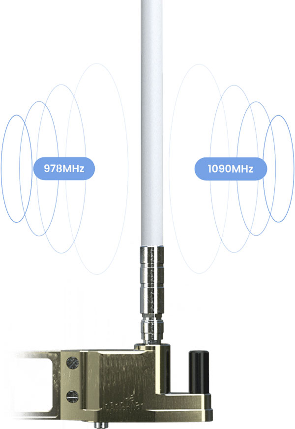
ADS-B Receiver
Enhances airport situational awareness
Photo: uAvionix
The pingStation 3 integrates 978 MHz and 1090 MHz ADS-B receivers, a GPS receiver, an antenna and a power-over-Ethernet (POE) interface into an easy-to-install, rugged weatherproof enclosure. With a selection of non-proprietary and industry-standard data interfaces, such as JSON and ASTERIX CAT 021, pingStation 3 is designed to integrate into a multitude of end-user applications, including airport displays, UAS Ground Control Stations (GCS), Unmanned Traffic Management (UTM) Solutions, and Flight Information Displays (FID). When paired with the VTU-20 airport vehicle ADS-B transmitter, pingStation 3 improves the situational awareness of ATCs and the safety of airport operations by reducing the risk of runway incursions.
uAvionix, uavionix.com
UAV
Defense UAS
Flexible UAV and control software combined
Photo: Ascent AeroSystems
Ascent AeroSystems’ Spirit coaxial unmanned aerial system (UAS) offers a versatile and durable system for mission-critical operations. With a modular, plug-and-play payload design, the Spirit’s open architecture allows operators to add or upgrade software to unlock new operating capabilities without the need to design or develop a new aircraft. Autonodyne’s additive software solution allows the Spirit to perform autonomous tasks either individually or as a team with multiple vehicles, from a single operator and control station.
Ascent AeroSystems, ascentaerosystems.com
Autonodyne, autonodyne.com
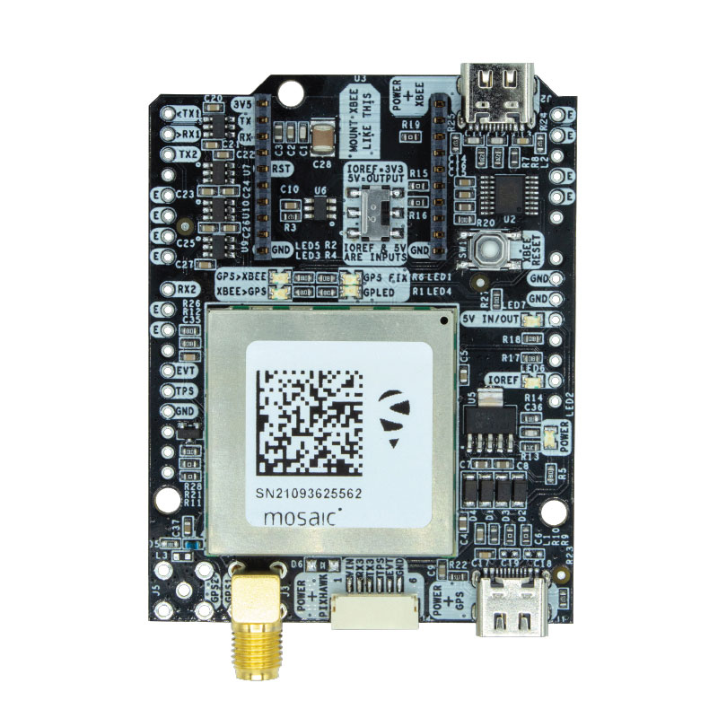
Evaluation Kits
Now include mosaic Septentrio modules
Photo: ArduSimple
Two Septentrio modules are being integrated into ArduSimple’s new evaluation kits — the mosaic-X5 GNSS module and the mosaic-H heading module. The new kits make resilient centimeter-level positioning easily accessible for testing and prototyping. ArduSimple’s kits provide triple-band real-time kinematic (RTK) GPS/GNSS as a plug-and-play solution for the most popular development platforms such as Arduino, STM Nucleo, Raspberry Pi, Ardupilot and Nvidia Jetson. It enables developers of robotics, UAVs and autonomous systems to try out mosaic, a unique module offering the latest high-performance GNSS positioning technology.
Septentrio, septentrio.com; ArduSimple, ardusimple.com
Geospatial Data
Drones as a service
Photo: Beagle
A drone network solution offers on-demand imagery to customers in Germany at resolutions up to 50 times higher than available from commercial satellite data providers. The Beagle M drone and sensors can deliver image data at 1-cm per pixel many times faster than satellites and regardless of cloud coverage. The company’s charging hangars enable quick flights. After completing an autonomous inspection flight (up to 200 km on a single charge), the drone returns to its hangar where it charges for its next mission. The drone takes just 90 minutes to become fully charged, and can then advance to its next mission without any physical contact between operator and aircraft.
Beagle Systems, beaglesystems.com
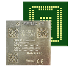
Nestwave is collaborating with Sequans to deliver accurate and efficient GNSS positioning for low-power internet of things tracking
The Nestwave IP provides the latest Sequans LTE-M/NB-IoT platform with geolocation. (Photo: Sequans)
Nestwave has announced that its technology has been selected by Sequans Communications S.A., provider of 5G/4G cellular internet of things (IoT) connectivity solutions. Specifically, Nestwave’s technology will add GNSS positioning to the Sequans Monarch 2 LTE-M/NB-IoT platform.
Integrated into the Sequans Monarch 2 GM02SP module, the Nestwave GNSS solution offers Sequans’ IoT customers accurate positioning with ultra-low-power consumption while minimizing component count, cost and size by removing the need for an external positioning chipset.
This makes the Sequans platform suitable for a wide variety of intermittent, power-limited tracking use cases including personal trackers, parcel and pallet location, and fleet trackers, as well as car, bike and scooter location and theft recovery. Cosmo Connected, a leader in urban mobility solutions, has already adopted the Monarch 2 GM02SP solution to reduce the cost and power consumption of its tracker products.
Nestwave’s technology allows geolocation to be added to existing IoT chipsets by implementing a GNSS receiver using the chip’s existing radio and computing capabilities. This eliminates the need for an external GNSS chipset and product redesign.
“Nestwave’s technology provides the smallest, most power efficient, and lowest component count solutions for IoT geolocation,” said Nestwave CEO Ambroise Popper. “Our strategic partnership with Sequans addresses the challenge of integrating accurate geolocation into compact, often battery-powered, low-cost IoT nodes and allows Sequans customers to benefit from higher performing, lower cost tracking solutions.”
“Leveraging Nestwave’s innovative technology to provide low-power GNSS on Monarch 2 widens its capabilities and makes many types of IoT tracker use cases more affordable because there is no need for additional positioning chips or modules,” said Georges Karam, Sequans CEO.
Nestwave IP has been integrated into a variety of chip architectures and on various DSP/CPU cores. In combination with Nestwave cloud services, this IP enables a very short time-to-first-fix, which allows for much lower power consumption in tracking use cases, without compromising on sensitivity or accuracy. The company’s technology roadmap includes the addition of 5G/4G cellular-based hybrid location functionality and solutions that will improve the accuracy of indoor tracking.
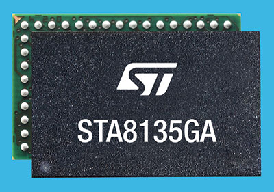
STMicroelectronics has introduced an automotive satellite-navigation chip designed to deliver high-quality position data needed by advanced driving systems.
Joining ST’s Teseo V family, the STA8135GA automotive-qualified GNSS receiver integrates a triple-band positioning measurement engine. It also provides standard multi-band position-velocity-time (PVT) and dead reckoning.
The STA8135GA’s triple-band enables the receiver to efficiently acquire and track the largest number of satellites in multiple constellations simultaneously for superior performance in difficult conditions such as in urban canyons and under tree cover.
Triple band has historically been used in professional applications such as surveying, mapping and precision agriculture that demand millimeter accuracy with minimal reliance on correction data, usually available on larger and more expensive modules than ST’s single-chip STA8135GA.
The compact STA8135GA will help driver-assistance systems make accurate decisions about the road ahead. The multi-constellation receiver delivers raw information for the host system to run any precise-positioning algorithm, such as PPP/RTK (precise point positioning/real-time kinematic). The receiver can track satellites in the GPS, GLONASS, BeiDou, Galileo, QZSS and NAVIC/IRNSS constellations.
The STA8135GA also integrates separate low-dropout voltage regulators on chip to supply the analog circuitry, digital core and input/output transceivers, simplifying selection of the external power supply.
The STA8135GA also enhances the performance of in-dash navigation systems, telematics equipment, smart antennas, V2X communication systems, marine navigation systems, drones, and other vehicles.
“The high precision and single-chip integration delivered by the STA8135GA satellite receiver enables the creation of reliable and affordable navigation systems that enable vehicles to be safer and more context aware,” said Luca Celant, general manager, ADAS, ASIC and Audio Division, Automotive and Discrete Group, STMicroelectronics. “Our unique in-house design resources and processes for high-yield manufacturing are among the critical capabilities that have made this industry-first device possible.”
The STA8135GA is housed in a 7 x 11 x 1.2 BGA package. Samples are available now and full qualification AEC-Q100 and Start Of Production are scheduled for the first quarter of 2022.
Trimble’s new GNSS base station gives users improved satellite tracking and remote operation for civil construction, geospatial and agriculture applications
Photo: Trimble
Trimble has introduced the Trimble R750 GNSS modular receiver, a connected base station for use in civil construction, geospatial and agricultural applications. The R750 provides high-accuracy base station performance, giving contractors, surveyors and farmers more reliable and precise positioning in the field.
The R750 can be used to broadcast real-time kinematic (RTK) corrections for a wide range of applications, including seismic surveying, monitoring, civil construction, precision agriculture and more. Access to all available satellite signals provides improved performance and reliability when used with a Trimble ProPoint GNSS rover. ProPoint gives users improved performance in challenging GNSS conditions, with improved signal management.
Featuring a built-in LTE modem, the R750 can provide corrections via the internet, making it easier to extend the range of a base station anywhere with cellular coverage. The built-in modem also provides remote access and management, delivery of email alerts and notifications, and data transfer capabilities between the field and the office.
“The R750 delivers significantly improved satellite tracking and connectivity, while also providing a vastly improved user experience,” said Scott Crozier, vice president of Trimble Construction Field Solutions. “The ability to manage the base station remotely, and to receive status notifications about the unit while in the office reduces downtime and the need to travel to the site. The new Trimble R750 is a game changer, especially for users who manage base stations in remote locations.”
For monitoring applications, the R750 provides precision capabilities for construction and geospatial customers deploying automated systems. Combined with Trimble 4D Control real-time monitoring software, users can capture high-frequency 3D positions for alarming and reporting on movement. The R750 offers multiple communication methods that provide flexibility for customers on how they deploy their monitoring system.
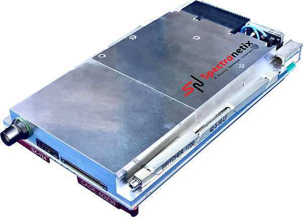
Spectranetix Inc., a Pacific Defense company, has announced the SX-124 ruggedized 3U OpenVPX high-performance positioning, navigation and timing (PNT) card.
With an ability to provide timing and positioning information in a GPS-denied environment through sensor fusion, the SX‑124 switch is designed for highly integrated systems with a requirement for the U.S. Army’s C5ISR Modular Open Suite of Standards (CMOSS) and alignment with the Open Group Sensor Open Systems Architecture (SOSA) technical standard.
The SX-124 can accept external sources or use its onboard GNSS receivers as reference inputs for timing and positioning data. The positioning data can be fused with internal and external inertial measurement units (IMUs). It distributes 11 100-MHz outputs and 11 1PPS outputs in a phase coherent manner.
The SX-124 provides timing and position holdover from an internal chip-scale atomic clock (CSAC) and IMU. A built-in time-of-day clock provides accurate network time stamps on system startup without GPS availability.
The SX-124 also provides enhanced location information and can be connected to an external IMU as well as a controlled reception pattern antenna (CPRA).
The SX-124 supports the standard VICTORY shared PNT services from a built-in GNSS timing receiver with an optional built-in M-code GB-GRAM receiver, CSAC and barometer to provide altitude information.
With the option for expansion to support over-the-air rekeying (OTAR), external fiber-optic gyroscope (FOG), alternative navigation (ALTNAV), and additional GNSS systems such as Galileo, the SX-124 supports the defense community’s need for a high-performance assured PNT (A-PNT) solution in the 3U VPX form factor and aligned to the latest open set of standards.
“Reliable situational awareness and cooperative, networked maneuvers demand assured PNT capability,” said Daniel Kilfoyle, CTO of Pacific Defense. “Our A-PNT solution embraces the pntOS open sensor-fusion framework and supports multiple sensor connections including GNSS receiver, GB-GRAM, IMU, FOG, CRPA and a two-channel software-defined RF receiver for added flexibility. Combined with exquisite timing and frequency performance and CMOSS alignment, this PNT card is yet another example of our commitment to CMOSS and SOSA.”
The SX-124 card is on track for production release early next year.
Tallysman Wireless Inc. has added the TW162A automotive-grade smart power GNSS signal splitter to its line of GNSS accessories.
The Tallysman TW162A signal splitter supports the full GNSS spectrum: GPS/QZSS-L1/L2/L5, QZSS-L6, GLONASS-G1/G2/G3, Galileo-E1/E5a/E5b/E6, BeiDou-B1/B2/B2a/B3, and L-band correction service frequency band.
Vehicle rooftop antenna space is often at a premium, and mission applications often require more than one GNSS receiver. The TW162A supports this use case where one GNSS antenna provides the signal to two GNSS receivers.
It also offers key fail-over and fault-identification features.
First, the splitter accepts power from all attached GNSS receivers; if one receiver fails, the next attached receiver automatically provides power to the splitter and antenna.
Second, if the antenna fails and does not draw current, all connected receivers will sense a current draw lower than 1 mA, indicating an antenna fault.
The TW162A offers high performance in terms of noise figure, isolation and linearity. TW162A is built with Automotive Electronics Council AEC-Q100 certified components, ensuring a wide operational temperature range and a long service life. It has been rigorously tested and is packaged in a durable, compact and lightweight aluminum housing.
The TW162A is available with three Z or A+B+C FAKRA connectors.
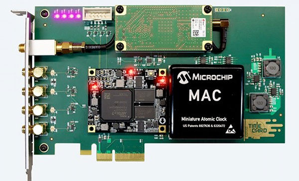
Facebook has open-sourced the design of its time card, which features the ultra-precise u‑blox ZED-F9T timing module, providing easy access to nanosecond-level timing
Photo: u-blox
Facebook has chosen the u‑bloxZED-F9T GNSS receiver module for timekeeping, according to u-blox. By improving the synchronization of networked computers, Facebook’s time card can significantly speed up the performance of its data centers and distributed databases.
By open-sourcing their designs, Facebook has bolstered the adoption of highly accurate timing solutions based on u‑blox technology. These solutions can be adopted by other industries requiring nanosecond-level timing, such as 5G cellular networks or smart power grids.
Facebook set out to create a precise timing solution that reduces the computational overhead required when synchronizing the timing between different computers in a network, u-blox said. The social media company used a u‑blox ZED-F9T multi-band GNSS receiver to sync up its solution with the highly accurate GNSS atomic clocks. To bridge possible gaps in GNSS coverage and keep clock drift to a minimum, the time card contains a backup timing source: a miniaturized atomic clock continuously synchronized with GNSS time.
To maximize the impact of the solution, Facebook decided to open-source the design of its time card, which fits onto a PCIe form factor. Anyone with experience working with microelectronics can turn any PC built on an x86 architecture and featuring a network interface controller into a nanosecond-level-accurate timing and synchronization solution, u-blox said.
Easy access to nanosecond-level timing accuracy — based on the u‑blox RCB-F9T timing board, which hosts the u‑blox ZED-F9T GNSS receiver — opens new avenues in industry segments that rely on highly synchronized signals, such as 5G network base stations that require tighter synchronization than those of previous generations, u-blox said.
As power-distribution networks become more complex to accommodate a growing share of decentralized renewable energy, they are becoming more reliant on reliable and accurate timing solutions. Data centers and computer networks will be able to modernize infrastructure management to speed up performance and reduce latencies.
Facebook has shared the GitHub repository including the specs, the schematics, the mechanics, the bill of material, and the source code in partnership with the Open Compute Project (OCP) under the Time Appliance Project (TAP).
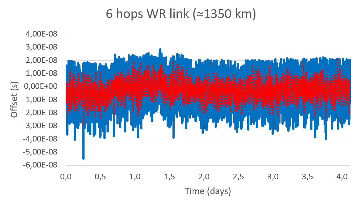
Seven Solutions sets new record for long-distance White Rabbit high-accuracy time-over-fiber link
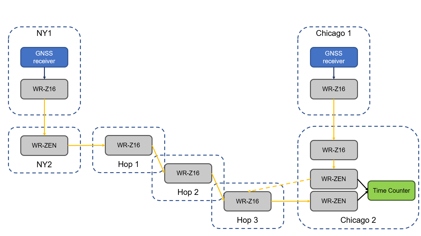
The White Rabbit link has an approximate distance of 1,350 km (840 miles) and was deployed in collaboration with Optiver U.S., a financial company, to connect Chicago and New Jersey trading locations. This link is formed by six long-distance White Rabbit hops using WR-Z16 and WR-ZEN TP devices connected by a combination of DWDM and SyncE-compliant transponders over a public telecommunication fiber network.
Seven Solutions is the leading company in the development and integration of high accuracy sub-nanosecond time transfer and frequency distribution for reliable industrial and scientific applications. Their technology integrates the White Rabbit protocol, the basis for the new high accuracy profile in the IEEE 1588-2019 (PTPv2.1).
This technology has become a reference for different sectors thanks to its unprecedented level of accuracy that outperforms current GNSS-based timing solutions, offering a suitable backup solution to deploy time dissemination networks. In the last few years, the White Rabbit technology has been adopted in the finance sector to deploy plug-and-play local area synchronization and metro-area links connecting different datacenters in financial hubs.
Although the performance of White Rabbit long distance links has been previously validated, this deployment sets a new distance record while integrating new resiliency and interoperability features using the latest WR-Z16 and the WR-ZEN TP devices.
Image: Seven Solutions
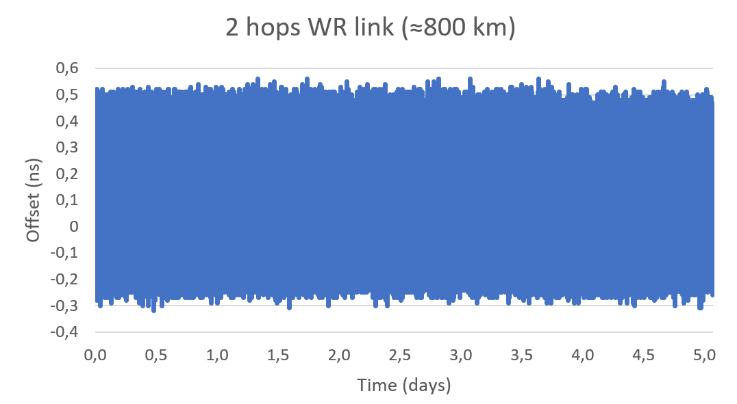
In a series of experiments, the link accuracy and precision were firstly validated setting a three long-distance hops loopback covering an approximate distance of 800 km (500 miles). In this case, the link was measured using an Agilent 53210A time interval counter for a five-day period. This experiment was intended to validate the feasibility of deploying White Rabbit links using commercial SyncE-compliant transponders and commercial telecommunication networks based on DWDM technologies.
Image: Seven Solutions
This measurement confirms the sub-nanosecond precision on a loopback and made it possible to perform network effect calibration to minimize the residual offset caused by the link asymmetry. In this case, a mean offset of 112 ps, a standard deviation equal to 139 ps and a peak-to-peak difference of 880 ps were obtained. Additionally, the offsets followed a gaussian distribution with no daily trends impacted by temperature or humidity.
This result proves the ability of high-accuracy time-over-fiber dissemination to fulfill the most demanding telecom requirements (class D Telecom Boundary Clocks) and corroborates one of the conclusions from the Analyzing a More Resilient National Positioning, Navigation, and Timing Capability report released by the RAND Corporation earlier this year:
“White Rabbit can support time transfer with accuracy that substantially exceeds the needs of almost all users; it is better than GPS. Therefore, this method is a strong candidate for backing up GPS time transfer for users that require atomic clock accuracy and for serving as a ‘national backbone’ for time so that secondary users, such as cellular networks, can perform to the limits of its own subdomain without suffering additional inaccuracies of its own master clock. Less accurate methods, like ordinary PTP, could provide timing to the vast number of other users, like mobile and cellular users.”
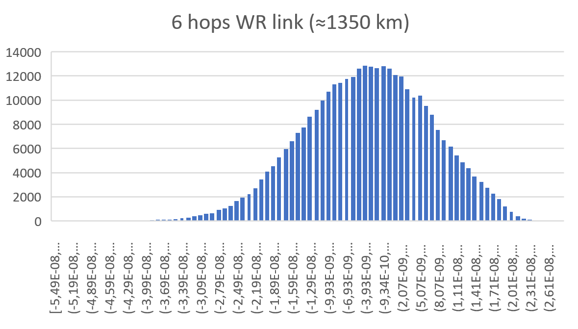
In a second test, the whole link was deployed using GNSS receivers in both ends of the link. The first GNSS receiver was used as the time reference in one end of the link (located in New Jersey) and the second GNSS receiver was used in the second end of the link to compare to the time reference (located in Chicago). Both GNSS receivers are the same model and have a 15 ns RMS jitter specification. In the second location, the local GNSS reference was compared to the remote time reference originating from New Jersey through the long-distance White Rabbit link.
Image: Seven Solutions
This resulted in a mean offset equal to 2.98 ns, a standard deviation equal to 10.4 ns and a peak-to-peak equal to 83.3 ns. It is noteworthy that due to the time interval counter, some of the samples were filtered. This effect is shown on the histogram but is considered negligible to validate the feasibility of the link.
Image: Seven Solutions
Additionally, the White Rabbit protocol automatically corrects daily effects due to temperature or humidity changes in the link, which are not observed in the measurement even when the GNSS receivers are located more than 1,000 km away from each other. This does not represent the real White Rabbit link error but indicates the limitation of using GNSS receiver to accurately measure the link accuracy.
As can be estimated from the measurements, the previous test and the GNSS specifications, the White Rabbit link maintains an approximately ±1 ns precision. In fact, the results show that the GNSS receivers are outperforming their specifications by almost 50%. The final accuracy is influenced by the GNSS receiver calibration. This link can be calibrated using network effect techniques (as shown in the previous experiment) or using the GNSS receivers themselves.
This experiment complements the results obtained in the U.S. Department of Transportation GPS backup demonstration showing the White Rabbit technology (which was catalogued as the most accurate alternative technology for time distribution) in a real telecommunications network scenario with very long distances. Additionally, it justifies the industrial need to deploy high accuracy time distribution when providing an alternative to GNSS-based timing, as it provides a next generation technology that can benefit other PNT systems and several critical infrastructures that rely on time synchronization for daily operations.
Beyond this, White Rabbit is demonstrated as a disruptive technology that can be used to measure the performance of GNSS in various locations to develop a warning and backup system, to connect high stability time references (for example, atomic clocks) for a suitable long-term ground-based backup to GNSS systems or to connect national metrology institutes around the world to compare different time scales.
This long-distance link represents a new milestone in ultra-accurate time transfer over existing telecom networks that allows cross-validating different linked references or accurately synchronizing them for coordinated actions at tight relative timing.
Furthermore, the deployment through existing telecom network proves its feasibility at affordable cost and opens the door to new disruptive applications. Atomic clocks have evolved to represent very stable references, but it has been typically assumed that time degrades as it is transferred over long distances making accurate comparisons between different references a challenge. This new generation of long-distance links represent a step further into tightly synchronizing different devices over fiber at long distances making them resilient to the vulnerabilities of GNSS timing.
This level of accuracy is key for certain applications and sectors nowadays. Matt Nassr, Data Engineering Lead at Optiver, remarked “Partnering with Seven Solutions has allowed us to better optimize for the highly distributed nature of the financial markets. Being able to establish a nanosecond-level precision link across the Chicago-New Jersey path further improves our ability to provide liquidity across the major US exchanges.”
“This is not a first step on the deployment of long-distance time synchronization networks, this is just one step further,” said Francisco Girela, Americas tech responsible at Seven Solutions. “We have been working for years on improving our devices, easing the monitoring and management, enhancing the resiliency, integrating failover features, adding interoperability with IEEE 1588 (PTP), NTP or PPS and allowing the integration of High Accuracy timing in third party devices thanks to the HATI core. During this journey we have learnt how to integrate the technology to work at its best and we have proved its effectiveness in telecom, data centers, finance, defense, or power grids among others.”
When asked about next steps, Francisco added, “We want to demystify this technology. People think that its deployment is complex or overkill, but that is not true. We see White Rabbit as the core technology to build alternative PNT systems, setting a sub-nanosecond timing foundation that will push the development of a more diverse and more accurate technology ecosystem.
“We have worked to evolve White Rabbit devices to be a market commodity when deploying time synchronization in local areas but providing a level of accuracy that will fulfill the requirements for the current applications and for the next decade. For long distances, complex deployments, or projects we are always happy to assist our customers and partners to get the best from our devices. We are sub-nanosecond natives; we care for every single picosecond.”