Tag: GNSS

  • ComNav Technology: Building Sweden’s Tallest Tower

    ComNav Technology: Building Sweden’s Tallest Tower

    When completed, the Karlatornet will be Sweden’s tallest building and redefine the skyline of the city of Gothenburg, rising to 74 stories and 246 meters (the Burj Khalifa in Dubai, currently the tallest human-made structure, is 828 meters high). Ensuring that the building remains stable even when deformed by very strong winds, sun exposure, seismic activity, settling or shrinkage will require very high precision construction methods. To ensure its vertical alignment, the engineers are using the core wall control survey (CWCS) method, which relies on active GNSS control points, and SinoGNSS T300S high accuracy GNSS receivers.

    A SinoGNSS multi-constellation T300 GNSS receiver and a 360° prism mounted at the top of a building under construction. (Photo: ComNav Technology)
    A SinoGNSS multi-constellation T300 GNSS receiver and a 360° prism mounted at the top of a building under construction. (Photo: ComNav Technology)

    The CWCS method was first used during the construction of the Burj Khalifa and was subsequently applied in the construction of many other high-rise buildings around the world. Swedish surveying company Teodoliten decided to apply this method for the Karlatornet project. Core walls, which are key structural components of high-rises, require a layered construction approach, with multiple concrete pours for each core wall element. CWCS makes it possible to precisely align these core walls with the vertical axis of the building during construction, using GNSS receivers, total stations, inclinometers, and other tools.

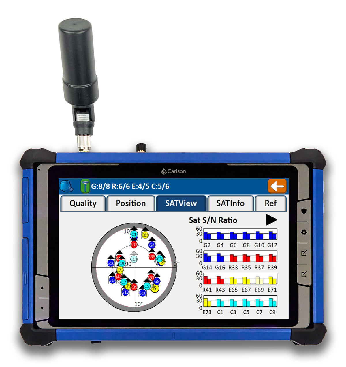
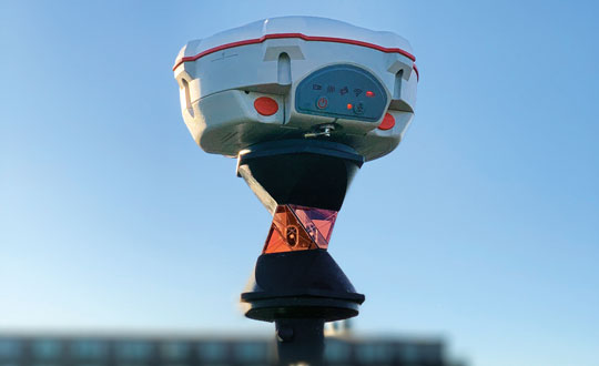
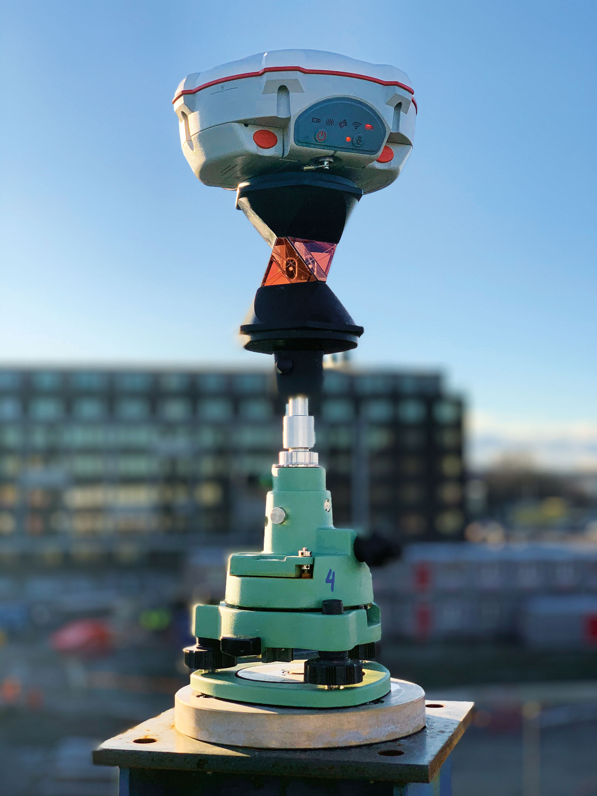
    When constructing a tall building, it is essential to continuously measure the positions of various elements at its summit to ensure their vertical alignment. This is typically done by placing at the top of the building four GNSS receivers — referred to in this context as active GNSS control points — each with a 360° prism at the bottom. By sighting the prisms and using the 3D coordinates from the GNSS receivers, a surveyor then sets up a total station. This obviates the need for an extensive array of ground control points, which are often not visible from the top, and for holes in the slabs to accommodate vertical laser plummets. Additionally, observations from a nearby reference station are used to post-process the data from the GNSS receivers in post-processed kinematic (PPK) mode to achieve an accuracy of a few millimeters. The Karlatornet project uses four SinoGNSS multi-constellation T300 GNSS receivers for the active control points.

    It is also necessary to correct for the movement of the survey platform as the building’s main axis is flexed by the loads applied to it during construction. This is achieved by placing a series of high-precision dual-axis inclinometers along the core walls and then applying a least squares adjustment that takes into consideration the floor height of the measuring devices.

    The SinoGNSS T300 receivers operating in GNSS-RTK mode also will be used to monitor and document post-construction building deformations.

  • Seen & Heard: Earthquakes and high-speed chases

    Seen & Heard: Earthquakes and high-speed chases

    “Seen & Heard” is a monthly feature of GPS World magazine, traveling the world to capture interesting and unusual news stories involving the GNSS/PNT industry.


    Photo:
    Image: Dennis Laughlin/iStock/Getty Images Plus/Getty Images

    GNSS records Alaska earthquake data 

    Researchers in Alaska were able to compare the quality of GNSS and seismic station data when assessing the magnitude 8.2 Chignik earthquake near Dillingham, Alaska. Research recorded by Revathy Parameswaran and colleagues at the University of Alaska, Fairbanks, shows that GNSS and acceleration seismic data can be used interchangeably or in tandem to estimate rapid magnitude or ground motion. The research showed the Chignik earthquake velocity records were almost identical at co-located GNSS and seismic stations for observations at frequencies of less than 0.25 Hz.


    No more high-speed chases

    Photo:
    Image: Screenshot from CBS New York video

    The Old Westbury Police Department of Long Island, New York, has chosen a high-speed pursuit alternative — GPS-equipped darts that relay the current location of suspects, reported CBS New York. It took $36,000 to equip six patrol cars with the air-powered dart launcher, called StarChase, which can be activated from inside the patrol car. When the launcher is activated, it shoots onto the suspect’s vehicle a dart with a GPS receiver inside and an adhesive exterior. It is considered a safe alternative to high-speed chases and safe to use around pedestrians.


    TikTok CEO says app doesn’t track 

    Photo:
    Image: Marco_Piunti/iStock/Getty Images Plus/Getty Images

    Shou Zi Chew, CEO of the popular app TikTok, testified before Congress that TikTok does not collect precise location data from its users. During the hearing, which lasted for more than five hours, Chew assured committee members the app does not collect nor distribute location data. TikTok is under fire as a bipartisan Senate proposal is aimed at banning the social media app, arguing it poses cybersecurity risks. The House Committee interrogated Chew regarding the app’s algorithmic feed, policies for young users and — given TikTok’s Chinese ownership — the amount of access the Chinese government has to user data.


    Just some water, please 

    Photo:
    Image: Bob Douglas/iStock/Getty Images Plus/Getty Images

    Satellite mapping data analyzed at Graz University of Technology’s Institute of Geodesy has revealed long-term drought conditions in Europe, reported GIM International. The data confirmed groundwater levels have been low consistently since 2018. The drought situation was originally published by Eva Boergens in “Geophysical Research Letters” in 2020 when she noted there was a severe water shortage in Central Europe during the summers of 2018 and 2019. There has been no significant rise in groundwater levels since then, and groundwater levels have stayed constantly low. 

  • Carlson Software releases multi-application tablet and GNSS solution

    Carlson Software releases multi-application tablet and GNSS solution

    Photo:
    Image: Carlson Software

    Carlson Software has released the RT5 rugged tablet data collector and the RTk5 GNSS solution, which integrates the form factor of the RT5 with real-time kinematic GNSS performance.

    The Carlson RT5 is designed for surveying, stake-outs, construction layout and GIS mapping, and is bundled with Carlson SurvPC — the Windows-based data collection program. The RT5 can run SurvPC with Esri OEM for use in the field.

    The Carlson RTk5 adds an advanced GNSS solution to the RT5, enabling accuracy in a compact, light and versatile package. It comes with a custom-built pole and cradle, a survey-grade antenna, and a small portable helix antenna for handheld GNSS use. It is suitable for land surveyors, engineers, GIS professionals, and users in need of advanced GNSS positioning with an RTK rover.

  • UK considering eLoran broadcast licenses

    UK considering eLoran broadcast licenses

    Photo:

    The United Kingdom’s spectrum agency, Ofcom, is seeking comments on its proposal to issue licenses for broadcasting eLoran signals and services. This initiative comes, it says, after the agency was “…approached with a request to authorize use of the 90-110 kHz spectrum for the provision of a long-range navigation system, based on eLoran technology.” Issuing licenses could be a way to treat all interested parties fairly.

    After briefly describing the importance of positioning, navigation, and timing (PNT) services to modern life, the Ofcom request for comment observes: “Satellite-based PNT systems like the Global Positioning System (GPS) can be susceptible to interference and can be vulnerable to space weather events. The eLoran technology provides a terrestrial-based alternative … which could in [the] future act as a supplementary or back-up system to GPS. [I]t has the potential to support innovation in the delivery of resilient PNT.”

    This rationale is quite similar to that cited by other governments operating Loran-like systems around the world.

    Until now, with a few minor exceptions, only government entities and those working on their behalf have been authorized to use the frequency. Such licenses would authorize holders to broadcast eLoran in the 90 kHz to 110 kHz band, which is the portion of spectrum reserved internationally for radio navigation.

    From October 2014 to December 2015, the UK had an operational eLoran network serving the waters off its east coast and authorized for maritime use. That system was discontinued when France and Norway bowed to pressure from supporters of Europe’s Galileo system, which was still in development. The UK Ministry of Defence still broadcasts a single eLoran signal from Anthorn, UK, that can be used as a wireless timing source.

    Several other nations currently broadcast some version of Loran in the 90 kHz to 110 kHz band. These include PNT systems operated by South Korea, Saudi Arabia, Russia and China. Reports indicate Iran is also broadcasting in the spectrum, though other details remain unclear.

    Unconfirmed reports from amateur radio operators in the United States seem to indicate that testing of Loran-like signals in the 90 kHz to 11 0kHz band has been conducted in North America periodically over the last 10 years.

    Until now, the UK has only formally authorized eLoran and the frequency for maritime use. Observers in the UK say this Ofcom initiative will almost certainly expand that to its use everywhere and for multiple applications, such as timing for critical infrastructure.

    Ofcom says, “[d]eployment of eLoran in the UK could complement existing PNT services, particularly in locations where there is poor GPS coverage or weak signals, like tunnels or deep inside buildings. eLoran could also provide resilience (i.e., back-up) for satellite-based systems against interference, jamming and spoofing, thereby aiding protection of key national infrastructure…”

    This Ofcom notice may be the first official move toward encouraging one or more entirely commercial eLoran services.

    Commercial wide-area PNT services capable of protecting critical infrastructure and national economies have long faced an uphill battle, though.

    Several industry leaders have commented that “it’s impossible to compete with free GNSS!”

    The same leaders have also criticized the U.S. government for not “walking the talk” when it comes to resilient PNT. At a U.S. Department of Transportation meeting last year they urged the government to not just tell others, but to set an example and protect itself with resilient PNT services. Doing so, they said, would show industry and users the government is serious and instill confidence that commercial services were reliable and would be sustained.

    Yet, experts cite a “chicken and egg” problem.

    “The government can’t subscribe to services that don’t exist, and companies can’t stand up and provide nation-wide services without having an anchor-customer first,” according to an industry insider.

    To solve this dilemma, public-private-partnerships have been proposed over the years in both the UK and the United States. To date, a willing “public” or government partner has yet to be identified for either nation.

    This might be changing in the UK government with growing awareness about the limitations of and threats to GNSS and other space systems. While a national strategy for PNT has been promised for years and is yet to be published, a cross-government PNT office has recently been established.

    “The UK is in a great position to lead the world on resilient PNT,” said one observer at a recent Royal Institute of Navigation event. “The key is working with GPS and other GNSS, while at the same time ensuring your nation has its own sovereign system independent of space. We (in the UK) have deep expertise and experience at the GLA (General Lighthouse Authority) with eLoran, and we have a superb tech economy. Britain could be the world’s leading producer of a resilient PNT tech stack that includes eLoran transmitters, receivers that use GNSS, eLoran, and other signals or phenomena, and all the supporting gear and IP (intellectual property) to make it all work.”

    “Realizing that vision will take a bit more government leadership than just issuing a few broadcast licenses, though,” they said.

  • QZSS hosted payloads delivered to Japan

    QZSS hosted payloads delivered to Japan

    Photo:
    Image: Todd Maki, United State Air Force

    The U.S. Space Force (USSF) has delivered two payloads to Japan for the Quasi-Zenith Satellite System (QZSS). The payloads will be integrated into two QZSS host satellites being prepared for launch, which will expand the QZSS constellation from five to seven satellites. 

    The QZSS hosted payload (QZSS-HP) is central to the USSF priority of expanding cooperation to contribute to international security. The mission is managed by the Space Domain Awareness and Combat Power Directorate (SDACP) of the Space Systems Command (SSC) within the USSF. 

    Massachusetts Institute of Technology’s Lincoln Laboratories (MIT/LL) is the primary payload developer for the QZSS-HP. MIT/LL and USSF personnel will travel to Japan to support the integration and test efforts with Japanese partners until both QZSS host satellites are launched.

  • ENC 2023’s abstract deadline is approaching

    ENC 2023’s abstract deadline is approaching

    Photo:
    Image: ENC23

    The annual European Navigation Conference (ENC23), set for May 31-June 2, will be hosted by the European Space Agency (ESA) at its ESTEC facilities in Noordwijk, The Netherlands. Abstracts are due no later than Jan. 24, and notification of acceptance or rejection will be sent out by the end of February.

    This year’s conference will focus on resilient navigation. Organized by The Netherlands Institute for Navigation (NIN), the conference will address resilience in the broadest sense, including navigation sub-functions, operational routines, standards and policies.

    The ENC23 tech committee has broken down the overarching theme into a range of topics, including integral end-to-end navigation solutions, specifics in position, navigation and timing (PNT), routing, data integrity questions and more.

    Early-bird registration is open now and ends March 15. General registration begins thereafter and the deadline to register is May 21. For more information about registration and abstract submission, visit the ENC23’s website.

  • GPS III SV06 launched

    GPS III SV06 launched

    GPS III Space Vehicle 06 (SV06) was launched Jan. 18 from Cape Canaveral Space Force Station in Florida at 7:24 a.m. EST. It is the 18th GPS satellite to broadcast the L5 signal. On Jan. 12, the Space Force Space Systems Command (SSC) had completed encapsulation of SV06 within the Falcon 9 payload.

    The launch of SV06 contributed to the SSC’s objective to create resilient GPS, which ensures all users have access to stable positioning, navigation, and timing (PNT) services. SV06, also known as SVN-79, will go through extensive on orbit testing after being introduced into the operational constellation on or about Jan. 25.

    Lockheed Martin Space Systems is the main contractor for the GPS III SV06 space vehicle and SpaceX provided launch services. This is Falcon 9’s fifth GPS launch since SpaceX launched GPS III-2 in December 2018.

    SV06 is named after the daring pilot Amelia Earhart — the first woman to fly solo across the Atlantic Ocean and to attempt to circumnavigate the world.

    The next launch — GPSIII-07 — will take place in 2024.

    Constellation Changes. The U.S Space Force Second Space Operations Squadron (2 SOPS) indicates that GPSIII-06, SVN-79/PRN-28, will expand the A2 node in the A plane.  It will be identified as position A2F in the vicinity of SVN-52.

    SVN-41/PRN-22, forecast unusable until further notice (FCSTUUFN) on Jan. 23, is being set unhealthy and will be used as a test vehicle in AEP.

  • Synaptics launches GNSS IC for IoT devices

    Synaptics launches GNSS IC for IoT devices

    Photo:
    Image: Synaptics

    On Jan. 3, Synaptics released the SYN4778, a small, low power, accurate GNSS integrated circuit for Internet of Things (IoT) devices. SYN4778 is designed to extend battery life, reduce product size, and enhance performance of advanced location-based services for IoT devices, including wearables, mobile accessories, asset tagging and tracking systems, UAVS and transportation navigation.

    SYN4778 includes advanced multi-path interference mitigation using L5 band signals from GPS, Galileo, BeiDou, NAVIC, SBAS, and Quasi Zenith Satellite System (QZSS). The chip also uses L1 satellite bands to reduce the time to first fix, as well as the power consumed, improving end-user experience, and enabling product developers to add additional functionality and features to their IoT devices.

    This GNSS chip includes LTE jamming and signal filtering, and continuous — highly parallel — search and track of all GNSS channels for greater positioning accuracy for LBS applications, specifically in urban environments. Additionally, it offers support for multiple operating systems and third-party software to enable a broader range of application-optimized IoT devices.

    SYN4778 is currently only available to select customers.

  • ASENSING ready to expand positioning solutions to global partners

    ASENSING ready to expand positioning solutions to global partners

    ASENSING, a Chinese positioning solutions company for autonomous vehicles, is ready to provide its navigation systems globally. The company already has more than 500,000 autonomous vehicles integrated with its navigation systems and is discussing global product expansion with major Western brands.

    ASENSING is the first in series production of an automotive solution that combines IMU and GNSS, enabling it to develop an algorithm to maintain navigation accuracy at various temperatures. Its positioning solutions are designed for autonomous driving at L2 level and above and meet functional safety requirements.

    ASENSING has received nominations from more than 20 OEMs to provide solutions for more than 70 vehicle models. Additionally, the company has partnerships with traditional brands such as SAIC, Geely, and Chery, as well as with new energy vehicle makers, including XPeng, Li Auto, and NIO.

    The company has three global branches, in the United States, Germany, and Japan with plans to launch more smart plants in east and south China to accommodate for an influx of orders. ASENSING will exhibit its mass-produced positioning solutions at the Consumer Technology Association’s Consumer Electronics Show 2023 in Las Vegas, Nevada.

    Photo:
    Image: Karneg/iStock/Getty Images Plus/Getty Images
  • Linux Foundation’s AgStack Project will build dataset of field boundaries

    Linux Foundation’s AgStack Project will build dataset of field boundaries

    Photo:
    Image: fotokostic /iStock/Getty Images Plus/Getty Images

    On Dec. 20, the Linux Foundation announced its AgStack Project, which will host an open-source code base, along with a fully automated, continuous computation engine that will maintain a global dataset of boundaries for agricultural fields. The AgStack Asset Registry dataset will aid food traceability, carbon tracking, crop production, and other field-level analytics.

    This ‘registry’ is designed to continuously update using data from satellites and real field registrations that contain boundary information, which will train machine learning models to ascertain more boundaries, among other capabilities.

    Agricultural datasets are rarely public information. By using computer science and artificial intelligence (AI), users can create global field boundaries as a digital open source for public use, which can help farmers, agricultural companies, and the public manage crop production, study management practices, assess levels of productivity, monitor the spread of pests and diseases and more.

    The AgStack project seeks to enable all types of agricultural data and services by combining computing and AI expertise with a global network of partners in an open-source software system. All code is being contributed under an open-source license and will be governed by the AgStack community, within the Linux Foundation.

  • Hexagon partners with ZF Group on autonomous driving systems

    Hexagon partners with ZF Group on autonomous driving systems

    Photo:

    On Dec. 20, Hexagon announced a partnership to integrate its software positioning engine and correction services with ZF Group’s ProConnect connectivity platform. This will enable vehicle communication in advanced driver assistance systems (ADAS) and autonomous driving systems.

    This integration is critical to providing the necessary functional safety, lane-level positioning accuracy and automotive safety integrity level (ASIL) rating that ZF’s automotive telematics platform requires. Hexagon’s TerraStar-X precise point positioning correction service will greatly improve the accuracy and reliability of ADAS and autonomous driving systems.

    Hexagons’ dual frequency and multi-constellation GNSS receivers are tightly coupled with inertial capabilities that withstand vehicle dynamics in all driving conditions.

    Both companies are focused on the next generation of mobility, including electric vehicles and autonomous systems, and this partnership helps advance safety and automation in the automotive and transportation industry. Hexagon and ZF plan to demonstrate their ADAS at the Consumer Electronics Show in Las Vegas in January 2023.

  • Climate change in the Big Basin mapped with GNSS and lidar technology

    Climate change in the Big Basin mapped with GNSS and lidar technology

    Photo:
    Image: demerzel21/iStock/Getty Images Plus/Getty Images

    CyArk, a California-based nonprofit, used UAVs, lidar and GNSS equipment to scan Big Basin Redwood State Park in Santa Cruz, California and create a model of it. The model shows drastic changes from climate change and the after-effects of the 2020 CZU Lightning Complex Fire.

    CyArk was contracted by the California park system and Google Art & Culture to document climate-related changes in the state forest, including the 2020 CZU Lightning Complex Fire, which burned more than 97% of the oldest park in California, destroying historic structures and most of the park. The fire was detrimental to the park’s landscape, which is still plagued by drought.

    DJI quad-rotor UAVs, a fixed-wing senseFly UAS, lidar and photogrammetry data brought in by RealityCapture software, and Topcon Positioning Group GNSS receivers among other technologies were used by CyArk to map the large-scale project.

    The model created from the flyover of the Big Basin can be seen here.

    CyArk digitally documents culturally historical places around the globe in 3D to preserve each site’s story using GNSS and lidar technology. They have worked at more than 200 sites in more than 40 countries.