CLEVELAND, Ohio — November 18, 2015 — GPS World relaunched this week with a redesigned print magazine and website, GPSWorld.com. Both feature a new logo, new design and widened coverage.
The GPS World brand has expanded its technical coverage to include all GNSS and Position, Navigation & Timing (PNT) solutions, trends and applications.
“We celebrated GPS World’s 25th anniversary in 2014 by embarking on the brand’s most-comprehensive research project to date,” said Kevin Stoltman, president and CEO of Cleveland-based North Coast Media, GPS World’s parent company.
The GPS World team conducted a research project and used a rebranding/repositioning expert to help better serve its industry-leading family of readers and marketing partners for decades to come.
“After months of comprehensive focus groups and surveys, we discovered readers and advertisers across the globe are fiercely loyal to GPS World,” Stoltman adds. “They love what we do, the information we offer. They just crave more of it: They want us to cover all GNSS and PNT technologies, trends and applications — and that’s exactly what we’re doing now, across all media platforms: print, digital and events.”
GPS World November 2015
The new GPS World publication also features a six-fold increase in segment-specific technical coverage — GNSS/PNT trends, obstacles and opportunities related to: Survey, Mapping, OEM, unmanned autonomous vehicles (UAVs), Defense, Mobile, Transportation and Machine Control. Those increase in segments also are reflected on GPSWorld.com.
“GNSS — and GPS as its leading element — remains at the core of all that we and the industry do,” said Alan Cameron, editor-in-chief and publisher of GPS World. “But it has become abundantly clear that to deliver the everywhere-everytime solution, GPS/GNSS require augmentation, back-up and alternatives. This is the promise of the future for UAVs, critical infrastructure, defense, machine control, surveying, construction and countless other fields: a consistent, highly accurate PNT solution at all times. Our new brand and expanded coverage represent our commitment to the industry in pursuit of this goal.”
The new website features a mobile-responsive design as well as new opportunities for website sponsorship with the Platinum Website Sponsorship option.
About GPS World
Founded in 1990, GPS World has an independently audited total unduplicated reach of 70,650 — delivering the largest audience in the industry. The B2B media brand publishes nine e-newsletters with a combined readership of more than 113,000, and conducts monthly technical webinars for engineers. Its website, GPSWorld.com, draws an industry-dominant 650,000 visitors and 1.5 million page views annually. (Source: June 2015 Verified Audit Circulation Annual Audit Report)
For more information on advertising or sponsorship opportunities with GPS World, please contact International Account Manager Michelle Mitchell at [email protected] or 216-363-7922.
GPS World is published by North Coast Media LLC, the largest B2B publishing company headquartered in Cleveland. NCM’s flagship brands include LP Gas, Pit & Quarry, GPS World, Pest Management Professional, Landscape Management and Golfdom. Ancillary brands include Portable Plants & Equipment, Geospatial Solutions, Athletic Turf, Truman’s Scientific Guide to Pest Management Operations and a host of other leading industry reference books.
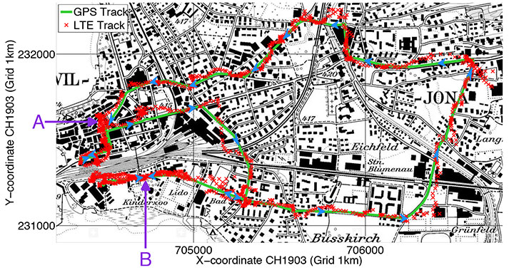
Rover positions obtained with 2D LTE versus GPS track.
Positioning with LTE Signals
An alternative to GNSS in urban canyons can be provided by signals from cellular base stations, particularly new signals from long-term evolution (LTE) networks, since LTE coverage will be high in cities. Wide LTE downlink bandwidth provides good resolution of multipath components, which also assists positioning.
A test used a universal software radio peripheral N210 synchronized to a GPS-locked Rubidium frequency standard. A personal computer stored LTE data samples together with GNSS sentences from a u-blox LEA-6T module. A Matlab-algorithm did the complete post-processing, extracting pseudoranges for the LTE base station and calculating the position solution.
Results of a car driven on an urban route show root-mean-square value of the absolute error using LTE compared to GPS position is 43 meters.
Positioning Using LTE Signals, by Fabian Knutti, Mischa Sabathy, Marco Driusso, Heinz Mathis, and Chris Marshall. Presented at the European Navigation Conference 2015.
Seamless Indoors
Sensor Augmented Indoor Navigation and Positioning, by M. Gemelli and Keith Nicholson, Bosch Sensortec. An overview of technologies that guide us indoors in a seamless and reliable manner, highlighting key requirements for motion and pressure sensing, low-power processing, efficient code design, wireless beaconing and map matching. Fusion software needs new data sources: Bluetooth low-energy, Wi-Fi fingerprinting, magnetic fingerprinting, ultrasound. Presented at ION GNSS+ 2015.
Disturbed Ionosphere
Mitigating satellite motion in GPS monitoring of traveling ionospheric disturbances (TIDs), by R.W. Penney and N.K. Jackson-Booth. Discusses the impact of satellite motion on the use of compact arrays of GPS receivers for estimating the velocity of travelling ionospheric disturbances (TIDs). It is shown that satellite motion has subtle effects upon standard techniques of waveform cross-correlation, or time-difference of arrival (TDOA), which can easily lead to spurious TID velocity estimates. In Radio Science, an AGU journal.
Q:Where do you see your efforts and thoseof your organization focusing primarily over the next 5–10 years?
Vidal Ashkenazi CEO, Nottingham Scientific Ltd.
A: GPS, and GNSS generally, will continue to be a big part of our work and remain at the core of our activities. We are not tied to a single technology, though. We are driven more by applications — and so we do not rule out the use of other sensors. As GNSS becomes more widely used and people expect more from it, we will make greater use of additional sensors to fulfil application requirements in more demanding environments.
A: GPS was the catalyst for a revolution in the application of precise position and time (that is, “Positime”).But it’s now 20 years old, and the developed world has become dependent on access to Positime, still mostly from GPS but with many likely complements/backups going forward. It is time to get serious and construct a layered PNT architecture to bolster GPS with regional and local/autonomous PNT sources for resiliency and precision.
Terence McGurn Consultant, U.S. Government
A: That we need alternatives to GNSS is now a given. But I see little discussion of the strategy for deploying those alternatives. Currently, we seem to emphasize detection and mitigation of the cause of a GNSS outage. To use a medical analogy, the cause of the patient’s accident is a “nice to know”, but the real issue is to keep the patient/service alive. So I’d like to see more focus on how — and how quickly — we activate the alternatives.
Registration is now open for the International Symposium on GNSS (IS-GNSS 2015), which will be held Nov. 16-19 in Kyoto, Japan. The early bird registration deadline has been extended and closes Aug. 31, and regular registration is Sept. 1-Oct. 31.
The International Symposium on GNSS is designed to bring together experts engaged in PNT and GNSS technologies — including industry professionals, practitioners, academics and researchers — to disseminate their latest research results and allow cross-disciplinary exchange of knowledge to further advance the fields.
Brad Parkinson will deliver the keynote address. Besides keynote addresses, the conference will feature oral presentations, interactive poster sessions, panel sessions, open interactive forums and an informative trade exhibition.
The Asia and Pacific Rim meeting of the CGIC (Civil GPS Service Interface Committee) will be co-located with ISGNSS 2015 to help improve understanding of world trends in developing and deploying GNSS.
Kyoto is the ancient capital of Japan and a top tourist destination, organizers said, with the conference scheduled during the best sightseeing season.
Registration will open April 1, along with a hotel booking page. The logistic information will be announced later.
A student scholarship is being offered to the student with the most promising paper. “If you have students, please encourage them to apply,” said Akio Yasuda, president of Institute of Positioning, Navigation and Timing of Japan.
Organizers of the International Symposium on GNSS (IS-GNSS 2015) have extended the deadline for submission of the abstracts for scholarship applied papers for one week. The new deadline is July 7 23:59:59 JST (UTC+9).
The one-week extension was added because organizers are presenting a paper in the Korean Institute on July 1.
The deadline for submitting abstracts for regular papers remains August 15.
The IS-GNSS 2015 will be held Nov. 16-19 in Kyoto, Japan. It will bring together experts engaged in PNT and GNSS technologies — including industry professionals, practitioners, academics and researchers — to share their latest research results and allow cross-disciplinary exchange of knowledge to advance the fields.
The student scholarship will be offered to a student with the most promising paper. “If you have students, please encourage them to apply,” said Akio Yasuda, president of Institute of Positioning, Navigation and Timing of Japan.
The program will include keynote addresses, oral presentations, interactive poster sessions, panel sessions, open interactive forums and an informative trade exhibition.
The Asia and Pacific Rim meeting of the CGIC (Civil GPS Service Interface Committee) will be co-located with ISGNSS 2015 to help improve understanding of world trends in developing and deploying GNSS.
For more information on the conference, including sponsorships and exhibits, email [email protected].
If you are a professional land surveyor, we’d like to hear from you! Send us a brief account of how you use GNSS in your surveying work, what tips and tricks you can share with other surveyors, and what other hardware and software you are combining with GNSS to get the job done.
Submit around 300 words, although you can certainly go longer if you wish. Five winners will be chosen from the submissions received at [email protected]; winners will be chosen on the basis of clarity, liveliness, and, in some small measure, the unusual nature of the surveying tasks you perform or the way you go about them. Winners will receive $100 gift cards.
But we’re interested in hearing about straight run-of-the-mill jobs, too! Send your entries to [email protected]. Some entries may also be chosen for further development into articles for this newsletter, or GPS World magazine, or other publishing opportunities.
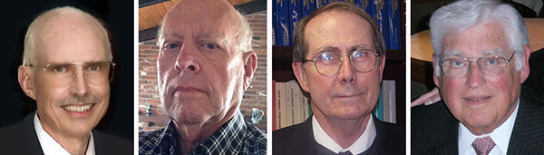
From left: Dennis McCarthy, Wayne Hanson, Ronald Beard and William Klepczynski
By Dennis McCarthy, Wayne Hanson, Ronald Beard and William Klepczynski
Once again we are going to adjust the world’s clocks by one second. This time it will happen on June 30, when we insert another leap second in Coordinated Universal Time (UTC), the standard international time scale. In theory, all UTC clocks should insert a second labeled 23h 59m 60s (the leap second) following one labeled 23h 59m 59s UTC. This is equivalent to having all of the clocks in the world stop for one second at that time.
Are you ready for it?
The last leap second occurred two years ago on June 30, 2012, and the continuation of the process of making these one-second adjustments has stirred a growing controversy over the last few years.
How did the leap second come about — and why do we continue making these sporadic adjustments?
From Sun to Caesium
Historically, it has been easy to make use of the apparently uniform repetition of various astronomical phenomena to measure the passage of time. We’re familiar with the Sun rising and setting, and this regularity provides us a convenient measure of time: the solar day. In recent times until 1960, the average solar day was used as the basis for timekeeping, and if we divide the day into 24 hours, each containing 60 minutes made up of 60 seconds, we can define the second as 1/86,400 of the mean solar day. This meant that the length of the second depended on the Earth’s rate of rotation because it is the rotating Earth that causes the Sun to appear to move across the sky.
In the mid-1930s, astronomers concluded that the Earth did not rotate uniformly as measured by the most precise clocks then available. This causes the duration of a second to vary as the Earth’s rotation rate varies. We now know that a variety of physical phenomena affect the Earth’s rotational speed, and consequently this definition of a second became impractical for applications that require a truly uniform time scale. So, in 1960, the second was redefined in terms of the Earth’s yearly orbital motion around the Sun. The time scale provided by this astronomical phenomenon was called Ephemeris Time (ET), to call attention to the fact that its realization depended on the conventionally adopted positions and motions (that is, the ephemeris) of the Sun (or Moon) that was used in the analyses of the required astronomical observations. The second defined in this manner was called the Ephemeris second.
Although Ephemeris Time does provide a more uniform measure of the duration of a second, it is inconvenient to make the necessary astronomical observations that would be required to maintain a practical time scale for applications that demand high precision. So, in 1967, the second was redefined again, this time in terms of the frequency of an energy level transition in the Caesium atom, which had already been calibrated with respect to Ephemeris Time by using astronomical observations of the Moon’s motion. Caesium frequency standards, by the early ’60s, had become known as reliable, uniform, accurate and precise clocks. The second defined in this way provided, and continues to provide, a uniform standard of time that can easily be measured in a laboratory with greater precision and accuracy than any astronomical phenomena.
Lab Clocks Rule
Although the second defined using the frequency of an atomic energy level transition does provide a unit of time duration that is precise and uniform, it does mean that the passage of time measured in this way is no longer connected to astronomical phenomena. Indeed, with the advent of more accurate observational techniques, astronomers could measure variations in the Earth’s rotation rate by measuring its changing orientation in space and comparing the rate of change with laboratory clocks. They established that among the various variations in the Earth’s rotation rate is the gradual slowing down with respect to a uniform atomic time scale. This deceleration is consistent with theoretical tidal effects and observed terrestrial deglaciation.It is also apparently consistent with ancient observations of solar eclipses, indicating that that this slowing has been going on for thousands of years
As a result, if we were to observe a recurring astronomical event, we would see it happening earlier from day to day. To bring our clock back into agreement with the astronomical event, we would have to add some time to the face of our atomic clock. While astronomers can cope with this situation by applying the appropriate corrections derived from astronomical observations that measure the Earth’s rotation rate, navigators that relied on astronomical observations to determine their positions considered this situation problematic.
When the definition of the second based on the Caesium atom was introduced, it was known that there would be a time varying discrepancy between a clock running at a uniform rate and a theoretical one using a second defined by the Earth’s rotation rate. Starting from 1961, the observed discrepancy was modeled by making small adjustments on the order of a few milliseconds (thousandths of a second) to our clocks at first, and later by making small adjustments to the frequency of the atomic clocks from time to time, usually on an annual basis. This meant that the duration of a second could vary depending on when it was measured.
No More Changes
In 1970 the International Radio Consultative Committee (CCIR and now known as the International Telecommunications Union Radiocommunications Sector, or ITU-R) in collaboration with other international agencies adopted a definition of UTC that did away with any periodic changes to the duration of the second. Instead it was decided that the discrepancy between UTC and the observed rotation angle of the Earth would be accounted for by making one-second adjustments when needed, so that the absolute difference between UTC and the Earth’s rotation angle measured in time units would always be less than 0.9 seconds. A finer correction would also be provided frequently so that the Earth’s rotation angle in time units designed as Universal Time 1 (UT1) could be derived to 0.1 second precision.
It was specified that the one-second adjustments, either positive or negative, were to be made preferably at 23h 59m 59s on the last day of the months of December or June, but could also be made, if necessary, at 23h 59m 59s on the last day of the months of March and September, and further if required at 23h 59m 59s on the last day of any month. The implementation of this definition actually began in 1972, a year in which two leap seconds were introduced.
These one-second adjustments came to be known as “leap” seconds by analogy with the “leap” day inserted in calendars. This definition then fixed the second in UTC to be uniformly established as the international standard atomic second defined by the resonance frequency of Caesium and known as the SI (Système International) second.
Compromise Overcome by GNSS
The introduction of the concept of the leap second was historically a compromise with practitioners of celestial navigation who needed to base their observations on astronomical time to determine their longitude. If UTC doesn’t differ from the observed rotation angle of the Earth by more than a second, navigators could use UTC directly as a substitute without introducing a systematic error greater than a quarter of a mile. However, the routine practice of using celestial navigation has been overcome by the success of Global Navigation Satellite Systems (GNSS), inertial navigation systems, and radar navigation.
In fact, the U.S. Naval Academy stopped including celestial navigation in its curriculum in 1998. In the time span since the introduction of the idea of a leap second, computer networks, wireless telecommunication systems, satellite communications, telephone networks, air traffic control systems and even industrial processes have developed to the point where precise time is an essential component of their successful operation. Users and suppliers of these systems are concerned with the impact of sporadic, essentially unpredictable, one-second adjustments.
Most of these modern systems derive their time using GPS timing receivers. Although the navigational solutions make use of GPS System Time, these receivers provide UTC by means of a broadcast correction that provides the time-varying difference between GPS System Time and UTC. This correction normally provides the varying difference between the two times to less than a microsecond but must also keep track of when a leap second is introduced. As the leap second changes occur sporadically, there may be worries that problems could arise because hardware or software may never have been tested thoroughly for a leap second occurrence. As a result of these concerns, as well as the cost of stopping all of the clocks in the world for one second, the ITU-R has been discussing a possible revision of the definition of UTC by dropping the future use of leap seconds.
Leap or Not Leap?
The question of the future of UTC was raised in 2000 with the suggestion of modifying it to be a continuous timescale without leap seconds. Consideration of this question is still ongoing. The 2012 World Radiocommunication Conference (WRC-12) identified this issue as urgent, requiring further examination by the 2015 World Radiocommunication Conference (WRC-15) “to consider the feasibility of achieving a continuous reference time-scale, whether by the modification of Coordinated Universal Time (UTC) or some other method, and take appropriate action…”.
With the aim of providing adequate technical background for WRC-15 to make an informed decision on this issue, the International Bureau of Weights and Measures (BIPM) and the ITU agreed to organize jointly a workshop on the future of the international time scale. This workshop was held in Geneva, Switzerland, in September 2013. It provided a unique opportunity to present available information on current and possible future precise frequency and time standards, sources and their characteristics, time scales and dissemination systems and different views on the future of UTC.
Contributions to the workshop were specifically invited to ensure that the breadth of the issue would be covered. Included were the relevant international organizations (the International Astronomical Union, the International Earth Rotation and Reference Systems Service, the International Union of Geodesy and Geophysics, the International Organization for Standardization, the International Maritime Organization, the International Civil Aviation Organization, the Union Radio-scientifique Internationale), the providers of GNSS services (GPS, GLONASS, Galileo and BeiDou), the national metrology institutes that realize and maintain local representations of UTC, the ITU member administrations, and the ITU-T and authorities responsible for electronic time services. Information on the workshop, agenda and presentations is available.
Final Decision in November
A special issue of ITU News magazine dedicated to the workshop has also been published; an online version is available. It did not provide a decision on the issues, but rather a forum for issues to be discussed, since there is some controversy over modifying the global reference time scale. The final decision is to be made at the WRC-15 in November when the method for satisfying the feasibility of achieving a continuous time scale will be determined as well as how it would be implemented.
As preparations begin for the June leap second, hardware and software will undergo testing. This process is likely to be repeated for some time to come, even if the decision to eliminate the use of leap seconds in UTC is made. Legacy systems reliant on the use of leap seconds will require an adequate period of time to adapt to any change in the definition of UTC. If the suppression of leap seconds would be decided, it is recommended that a period of time no less than five years be allowed before the Final Acts of the WRC-15 go into effect. So, leap seconds could be with us for some time yet.
Editor’s Note: For an earlier discussion on the leap second by McCarthy and Klepczynski, download the Innovation article “GPS and Leap Seconds: Time to Change?” from the November 1999 issue of GPS World.
Dennis McCarthy is retired, and serves as a contractor with the U. S. Naval Observatory, where he was science advisor, director of the Directorate of Time, and head of the Earth Orientation Department. Internationally, he has served as president of the Commissions on Time, Commission on Earth Orientation, and Division 1 (Fundamental Astronomy) of the International Astronomical Union (IAU). He was also secretary of Commission 5 of the International Association of Geodesy.
Wayne Hanson has been a consultant and president of Time Signal Engineering since his retirement in 2001 as chief of the Time and Frequency Services Group in the Time and Frequency Division of the National Institute of Standards and Technology. He is the U.S. chairman of the International Telecommunication Union – Radiocommunication Sector, Working Party 7A concerned with Time Signal and Frequency Standard Emissions.
Ron Beard is the head of the Advanced Space PNT Branch at the Naval Research Laboratory and International Chairman of ITU-R Working Party 7A, Precise Time and Frequency Broadcast Services. During the early development of GPS in the 1970s, he was the project scientist in the NRL GPS Program Office that developed Navigation Technology Satellites One and Two that operated the first atomic clocks in space.
William Klepczynski is now retired. During his career, he was a consultant to the Institute for Defense Analyses and the head of the Time Service Department of the U.S. Naval Observatory, where he managed the USNO Master Clock, timing operations for GPS and time distribution systems that utilize communications and navigation systems.
Darren McCarthy, Rohde & Schwarz, gives GPS World a booth tour of its GNSS solutions, avionics gear and interference hunting solutions while at the 2014 ION GNSS+ Conference, held September 9-12 in Tampa, Florida.
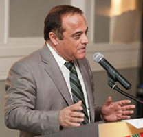
“Use any opportunity to create friendship and peace,” urged Javad Ashjaee, president and CEO of JAVAD GNSS, in a May 23 conversation with journalists. He decried the recent controversy about monitoring stations on both U.S. and Russian soil, saying it was based in misinformation and misinterpretations, inflated by a political crisis in a completely different area. “This [GNSS] is a good thing, that for 25 years kept us together. And if you see, there are lots of high-level meetings between U.S. and Russian officials, they are all very friendly meetings.”
A transcription of his remarks appears here, below the following main points and clarifications that he wished to make:
• Earlier this year, Russia sought GLONASS monitoring stations in the United States, not for uploading any data, but for monitoring GLONASS satellites to provide more accurate orbit and clock information, for the free and open benefit of all users.
• The Russian general who threatened to close down monitoring stations on Russian soil that contribute data to the International GNSS Service was immediately and roundly criticized by Russian scientists and surveyors. The general subsequently retracted his remarks.
• The 11-hour GLONASS outage on April 1 was not due to a wait for all satellites to pass over ground control stations on Russian soil to receive a fresh upload of data. GLONASS has the capability (as does GPS) to make such updates via inter-satellite communication. The delay was caused by the time it took to find the bug in the erroneous software that had been uploaded, and to correct it.
• Ashjaee also noted that “No military activity requires millimeter accuracy. It is only scientific applications for humanitarian tasks that require millimeter accuracy. Needing more monitoring stations, such as the IGS stations, is only for that purpose.”
The Background
Javad Ashjaee, founder and CEO of JAVAD GNSS, contacted GPS World on May 20 with a message: “I had a discussion today with the head of the GLONASS program in RosKosmos regarding the tracking sites that they wanted to establish in the United States, and the subsequent events. What has been published in most U.S. media is far from the truth. It is time that we contribute to defusing problems rather than putting more fuel on the fire. The world has enough problems already.”
The Full Statement
This is the story of GPS/GLONASS. It also gives some insight as to how things get out of control, and much, much bigger issues like war and things like Ukraine get created. It is just a tiny, simple example.
When I first heard the issue of GLONASS about 25 years ago and was invited by RosKosmos to Moscow, I didn’t think of Communism or anything political, I thought “30 satellites free, that they’re willing to give to the world, free of charge.” That’s how I got excited. Recently, GPS World published a wonderful history of the growing development of GLONASS and GPS.
What bothers me now is some negative reactions that I see towards GLONASS. It seems that when they see something negative about GLONASS, they enjoy it. In the reports, read between the lines. When there is a problem with GLONASS, you sense some sort of happiness. There is something of “them versus us.”
There was the question, “Why do they need things in our country? Don’t they have them in their country?”
When people don’t know each other, they fear and they create fear.
One thing we should look at: GLONASS is good for all of us. As President Reagan offered GPS free of charge to the world, and everybody applauded him — the Russians have done the same thing. In Oklahoma, California, everywhere, farmers and surveyors are using GLONASS free of charge, the same as GPS. And GLONASS has been better, and I emphasize, it has been better because they didn’t encrypt their code so that we had to go behind and decipher and decrypt and all the trouble that we went to during the past 20 years, because GPS didn’t think that we need carrier phase.
GLONASS is good for America, for the world, as is GPS. If there is a problem with GLONASS, we must be unhappy, as we are unhappy when there is a problem with GPS. And if we can help GLONASS, we must help GLONASS. There is nothing to fear about war, nobody needs [millimeter-level] accuracy of GPS or GLONASS if there is a war between super-powers.
We should all want GLONASS to give precise information. We care about centimeter-level accuracy, the military doesn’t. Five-meter accuracy is good enough for them. To improve the precise-orbit information of GLONASS is the concern of surveyors and those that need precision GPS.
Now, what’s the issue? GLONASS needs 50 reference stations all around the world to monitor the orbits of its satellites, to make the precise-orbit information [furnished to users] better. Not to upload information to the satellites. For this, one station is enough, for both GPS and GLONASS, because both have inter-satellite connections that can do this.
There was speculation in early April that it took GLONASS 11 hours to correct a software bug because it took that long for all the satellites to pass over a control station on Russian soil. This was not the case, I have learned from conversations with their engineers and with the head person responsible for all of this. One engineer made a mistake and uploaded the wrong software. Until they could find it and debug it — and it took them 11 hours to do so — they could not upload correct software to the satellites.
What they are asking for from the United States is not an upload station. They need as many [globally-distributed] monitoring stations as possible; 50 is good.
The International GNSS Service (IGS) has 300. To have a good orbit determination for scientific work, to get to the depth of centimeter- or millimeter-level accuracy, the objectives of IGS reports is to have 200 or 300 monitoring stations. For military work, three or four is enough.
Russia already has more than 50 monitoring stations. They use IGS stations. They didn’t need to ask for anything. Even [data from] the units we have in our San Jose office is available to everybody.
So I asked the GLONASS people, “Why did you ask? You have [access to more than] 200 monitoring stations!”
This was the issue: it was only political. When RosKosmos made internal presentations in Russia to their [government and military] decision-makers, they were asked, “OK, these stations are controlled by who?” By the IGS, they answered. They were told “You must have stations under Russian control.”
I explained to them that IGS stations, for them, are more convenient and more secure. If President Obama told the IGS, told Stanford University and 200 other universities, to turn off their IGS stations, there would be a lot of disagreement! President Obama could turn off Russian stations on U.S. soil. I told them, IGS stations are more convenient and more secure for you than your own stations, and they understood. They are not pushing for it, they said those officials on the top, they know nothing. They were asking that we must have five stations under our control.
If you understand this: that the issue was [Russian internal] political, that they don’t need anything. They already get the precise orbit data from IGS stations.
Now, the second part or episode of this problem: when a Russian general heard that the United States said “No” to the request for Russian-controlled monitoring stations on U.S. soil, he said “Oh, now they don’t let us do this? We will turn off their stations in Russia.” All surveyors and all scientists in Russia jumped at that general, and he retracted what he had said.
But people who didn’t understand this [that IGS-participating stations in Russia have nothing to do with controlling GPS satellites or supplying GPS data to users], they put their own statements in the press, they added fuel to the fire.
The Q&A
When asked how surveyors in Oklahoma could help GLONASS, as he had urged, Ashjaee replied “They can write to their senators and ask, why didn’t you let monitoring stations be in the heart of Oklahoma too?”
Afterthought
Once the first version of this online story was posted, Javad Ashjaee sent in this further comment:
“Part of my admiration for the GLONASS team is that they managed to pull this project off amidst their worst economical, social, and political times. Compare their situation with GPS that had a huge budget (and still ran way over budget) and with Galileo that took several rich countries to put the budgets and technology together. GLONASS also offered this free and unrestricted service to the world without making any political gestures. No encryption of codes and no selective availability either.
“There is an abundance of opportunities to create hostility, and there are enough people to promote it. Situations like this are rare that we can grasp the opportunity to promote friendship.”
The ESA Summer School is scheduled for July 21-31, at the Campus of the Technical University of Ostrava, Czech Republic. The school provides attendees with a comprehensive overview of satellite navigation, starting from the various GNSS, the signals, the processing of the observations in a receiver, and finally determining the position-navigation-time (PNT) solution.
Lab work will be carried out to give attendees hands-on experience. In addition, lectures on Intellectual Property Rights (IPR) and Patents, as well as on business aspects will be provided. The future of satellite systems will also be discussed. The main emphasis will be on the development of a group project using innovative ideas and covering all aspects, from the idea, business plan, and technical realization to the marketing of the product or service.
The program is open to graduate students (with a first university degree), Ph.D. candidates, early-stage researchers and young professional willing to broaden their knowledge. International renowned scientists and specialists will give the lectures as well as the practical exercises and lab work.
The following participants can register for the ESA Summer School:
Graduate students (more than 3 years studies)
Ph.D. students and postdoctoral researchers (< 35 years)
Young engineers and professionals from industry and agencies (< 35 years)
The number of participants is limited to 50. Early registration (reduced rate) is recommended (first come, first serve).
Calling it an “unprecedented and deeply worrying total disruption . . . [that] shook the industry,” Locata Corporation reiterated its call for redundant terrestrial systems to back up GNSS in the wake of the April 1 11-hour GLONASS system outage.
Nunzio Gambale, Locata CEO, said “We have been telling the industry for years that you cannot have a critically important capability like GPS without also having a backup! What is Plan B if the satellite systems fail? What replaces the space signal when there is a problem? If anyone needed a sign to understand why Locata has spent years inventing and developing the world’s first local terrestrial equivalent of the GPS system, then last week’s meltdown of a complete global satellite navigation system is it. This event should terrify every nation, government, and company that depends on navigation satellites for their business or, in some cases, their very lives.”
The navigation and timing functions of the global positioning systems underpin the world’s banking systems, stock exchanges, digital TV and Internet, cell phone networks, and, in some cases, the national electricity supply, Locata pointed out. GPS, in particular, plays a crucial role in transportation, shipping, and logistics, serving as the enabling technology for critical functions like air traffic control. Reliability is therefore not just important; it is essential across all applications. Locata, the Resilient Navigation and Timing Foundation (RNTF) in Washington, D.C., and others have persistently called attention to the need for redundant terrestrial systems that will back up expensive, vulnerable, and aging global satellite navigation constellations while simultaneously providing the local control and resiliency that satellite-based systems cannot deliver.
Professor Chris Rizos of the School of Civil and Environmental Engineering at the University of New South Wales stated that “This catastrophic failure of one of the world’s two global satellite navigation constellations is a wakeup call for all of us. We ignore the possibility of these ‘Black Swan’ events at our own peril.”
The GLONASS disruption was felt around the world, immediately upon its origination, especially in professional applications, such as tractor automation for farming, machine control and robotics in mining and heavy industry, and in the national infrastructure used by surveyors and industry across many countries.
“This shows just how interlinked the physical and cyber worlds have now become,” added Professor Brett Biddington, a space and cybersecurity expert from the School of Computer and Security Science at Edith Cowan University, Australia. “The prospect of a software glitch, whether unintentional or intentional, seems highly likely [as a cause for the failure]. If it was a deliberate attack, however, it points to a changing face of warfare where the real enemy may be impossible to detect and deter until very damaging strikes, such as an attack on the GPS system, have already taken place.
“The vital point here is that this is no longer just a question for scientists and technologists. A locally controlled backup system for this essential signal is a national policy question of the highest order.”
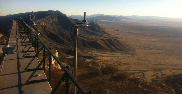
Locata Corporation and other industry authorities have long testified on global satellite navigation vulnerabilities and the need for diverse technology options to strengthen and back up GPS, GLONASS, and other systems. Locata developed a robust solution and has been awarded a sole-source contract by the U.S. Air Force (USAF) to provide its terrestrially based alternative positioning for military applications where GPS has been completely jammed. The first wide-area Locata system is being deployed now at the White Sands Missile Range in New Mexico. The USAF demonstrated that the White Sands Locata network delivers what has been extremely high accuracy over a 2,500-square mile area, positioning aircraft flying up to 35 miles away to an accuracy of better than six inches.
A pair of LocataLite transmit antennas overlook a section of the White Sands Missile Range blanketed by the Locata high-precision ground-based positioning system.
“There is no other technology that can do this, and it’s delivered in the complete absence of GPS,” continued Gambale. “What is being demonstrated at White Sands is that Locata supplies precisely the same function as GPS, even when there is no GPS available. That’s exactly what you need if the satellites fail.
“If this event had been a GPS failure instead of a GLONASS failure – and it could very easily have been – then the entire world would have plunged into a catastrophe. This event is the navigation equivalent of a ‘close call moment,’ and from here on out no one can even question that this is a really serious problem that must be addressed. Another industry expert recently told me, ‘If there was a sustained GPS outage, it would cause a global financial nuclear winter from which it would take us decades to recover.’”
Gambale concluded, “We need action to develop local backups like Locata around places like airports and other strategically important areas – now! We must not wait until we are faced with another seemingly impossible event like a complete satellite constellation failure. We may not dodge this bullet a second time.”
Locata terrestrial positioning technologies complement GPS by setting up ground-based transmitters, called LocataLites, to create a local constellation called a LocataNet. Once properly deployed, Locata’s unique nanosecond-accurate TimeLoc system synchronizes the network, which allows it to replicate the positioning capabilities of GPS, locally. LocataNets operate today in environments ranging from small warehouses to open-cut mines, wide-area aircraft approach-and-landing systems, and wider areas for aircraft and unmanned aerial vehicle (UAV) uses.
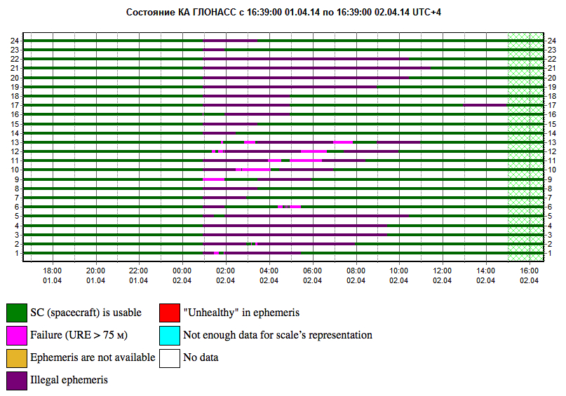
Yesterday we posted news of an 11-hour downtime for the full GLONASS constellation, due to an upload of bad ephemerides. Coincidentally, during that 11-hour period, the mass-market chip company Broadcom was conducting multi-constellation receiver tests in Asia. Frank van Diggelen, Broadcom’s chief GNSS scientist and vice president says, “We have definitive data to show how a multi-constellation receiver survives such an outage.”
Here are the pictures, and the story they tell.
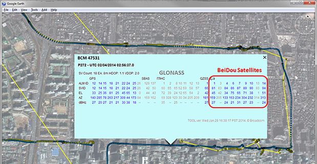
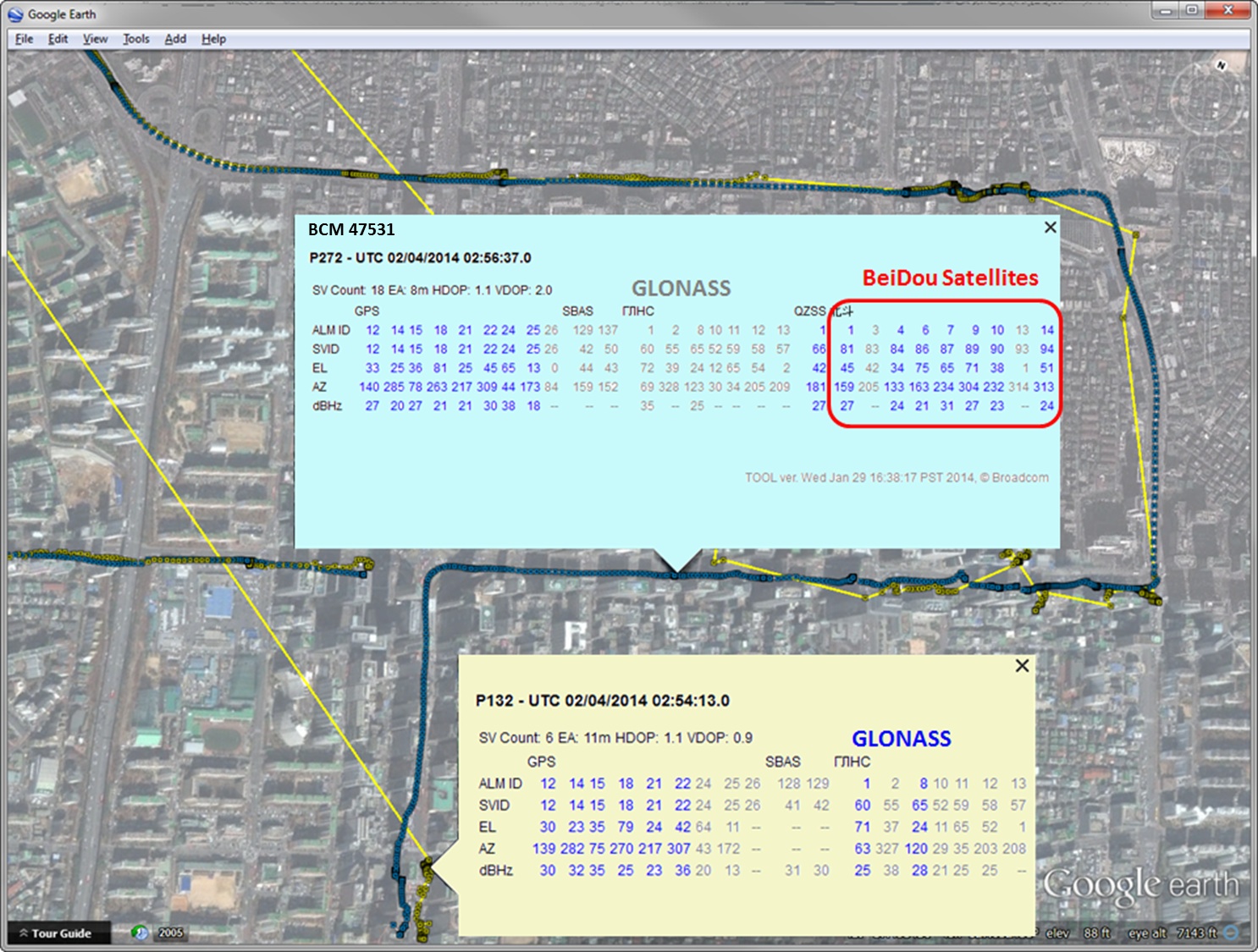
Test data coincident with the GLONASS ephemeris disruption of April 1 and 2 showing conclusively how a GPS/GLONASS/QZSS/BEIDOU receiver survives the complete disruption of one of the constellations.
On April 2 at 1:00 a.m. Moscow time, bad ephemeris was uploaded to all satellites (see chart at the bottom of this story).
There are two receivers shown here, from two different manufacturers, both in smartphones. The yellow dots are for a GPS/GLONASS receiver; the blue dots are from the Broadcom 47531 receiver which tracks GPS/GLONASS/QZSS/BeiDou signals simultaneously. The 47531 receiver includes logic to use redundant measurements to check the validity of all measurements. It successfully identified and removed the bad GLONASS ephemeris 100 percent of the time, as can be seen by the continuity and accuracy of the positions.
Here is the satellite outage chart from yesterday’s story. All GLONASS satellites were restored to healthy state after the 11-hour interruption.
Current plot from the Roscosmos GLONASS Information-Analytical Centre. Things are almost back to normal this morning.