Two U.S. Air Force officers provided a GPS program update at Tuesday morning’s Civil GPS Service Interface Committee meeting plenary session at the ION GNSS+ 2014 conference in Tampa, Florida. Here are some key points from the presentations by Colonel Matthew Smitham, deputy director, GPS Directorate, and Lieutenant Colonel Todd Benson, Commander, Second Space Operations Squadron:
31 primary satellites on orbit, 7 satellites in residual status, 1 satellite in test status
best weekly URE of 58.7 cm during week of 18 August 2014
newer satellites typically perform better than older ones
anticipate URE dropping to about 30 cm in a few years as more modern satellites come on line
60-70 navigation data uploads to the satellites are performed each day; average of about two per satellite per day
IIFs:
SV 3 and SVs 5-12 have improved rubidium clocks; one of the IIFs is running on a cesium clock
14 SVs are currently broadcasting L2C (set healthy); 7 SVs are broadcasting L5 (set unhealthy)
CNAV:
Data uploads are currently being done about twice per week to each satellite; daily updates expected by December 2014
average UREs currently about 1.4 m (data ages quickly with few uploads per week); expect CNAV URE to be marginally better than LNAV (Legacy NAV) when daily uploads begin
Continued progress in bringing M-code on line; expect early use by 2017
GPS III:
satellites will use three improved rubidium clocks
although the program is behind schedule, SV 1 will be available for launch starting in January 2016
the Block 0 version of the OCX (Next Generation Operational Control System), currently under test, will be needed to support the GPS III satellites
The U.S. Air Force’s fleet of GPS Block IIR and IIR-M satellites, manufactured by Lockheed Martin, have reached 200 collective years of operational life. The 20 satellites make up about two thirds of the current GPS constellation.
Originally launched between 1997 and 2009 to add capabilities to the GPS constellation and to replace other aging satellites, the 12 GPS IIR and eight IIR-M satellites have maintained an availability record of 99.96 percent, which represents only 10 minutes of down time per satellite during all their years of operation.
The 200-year milestone will be celebrated with a brief cake-cutting “ceremony” during ION GNSS, on Wednesday at 12:30 p.m., at the Lockheed Martin booth.
“This is a tremendous GPS operations and sustainment performance milestone, and we applaud the men and women of the Second Space Operations Squadron of the Air Force’s 50th Space Wing, as well as the industry team who support them,” said Mark Stewart, vice president for Lockheed Martin’s Navigation Systems mission area. “The world relies on GPS every day for things like synchronizing global banking and investing, shipping and transportation, search and rescue operations, ATM transactions and even precision farming.”
This spring, the IIR-M satellites played a major role in the continued modernization of the GPS constellation. To help manufacturers develop and test next-generation advanced civil GPS receivers, under the direction of Air Force Space Command and in collaboration with the Department of Transportation, these satellites began early broadcasting of test civilian navigation, or CNAV, messages on a new signal planned for all future satellites.
Making these milestones even more significant is the fact that the GPS IIR and IIR-M satellites were designed to last 7.5 years, or collectively about 150 years. All 12 IIR satellites are currently operating beyond their design life with the oldest operating for more than 16.5 years. Three of eight GPS IIR-M satellites have surpassed their expected life span and all satellites will have done so in 2017.
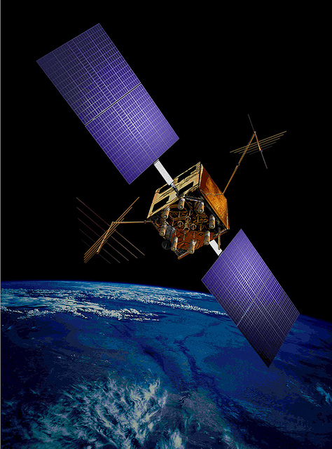
To meet evolving GPS user demands, Lockheed Martin is developing the next-generation GPS III satellites. These satellites will deliver three times better accuracy, provide up to eight times improved anti-jamming capabilities, and include enhancements which extend spacecraft life to 15 years, 25 percent longer than the newest Block IIF satellites. GPS III will be the first generation of GPS satellite with a new L1C civil signal designed to make it interoperable with other international GNSS.
Starting Friday, September 5, GPS satellite SVN-35 will resume transmitting L-band signals using PRN03, according to a Notice Advisory to Navstar Users (NANU) issued today.
According to GPS WorldAlmanac editor Richard Langley, the resumption is being done in an effort to determine the exact status of SVN-35’s remaining clock. However, the satellite will remain unusable as the Air Force conducts its tests.
Below is the full text of the NANU.
NOTICE ADVISORY TO NAVSTAR USERS (NANU) 2014069 NANU TYPE: GENERAL
*** GENERAL MESSAGE TO ALL GPS USERS ***
On approximately 05 Sep 2014 SVN35 will resume transmitting L-band utilizing PRN03. At L-band activation, SVN35/PRN03 will be unusable until further notice. Additionally, no broadcast almanacs will include SVN35/PRN03 until further notice.
RT Logic has been awarded a $1 million follow-on contract to provide ground system components for the USAF GPS OCX program, bringing RT Logic’s total OCX contract awards to over $4 million. RT Logic is a subsidiary of Kratos Defense & Security Solutions, Inc.
OCX is the next generation GPS ground system designed to bring flexibility, adaptability, and modularity to the position, navigation, and timing (PNT) mission. RT Logic is the primary equipment supplier for the Command and Control (C2) portion of OCX, providing software front-end processor units and Air Force Satellite Control Network (AFSCN) gateways.
RT Logic supports Raytheon, the prime contractor for GPS OCX, with RT Logic’s net-centric software products for C2 of the GPS III satellites using next generation IP cryptosystems. The IP cryptosystems use industry-standard IP interfaces, eliminating the need for custom serial interfaces, which is intended to ease integration challenges, improve reliability, lower transition risk, and reduce cost.
RT Logic’s software-based products will enable Raytheon to add new features to meet evolving requirements as needed, the company said. In addition, RT Logic will build a high-fidelity lab environment that simulates the GPS mission string. This lab system will allow Raytheon to cost-effectively resolve issues, integrate and simulate new functionality, and maintain the system without impacting the operational mission or Raytheon’s regression testing schedules, the company said.
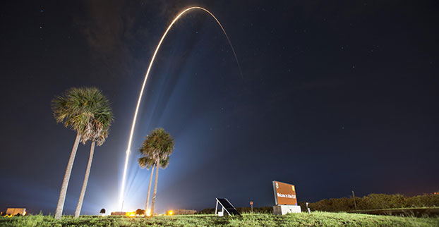
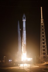
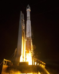
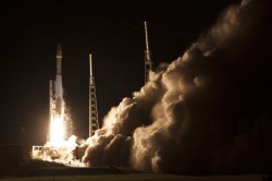
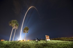
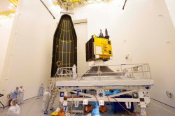
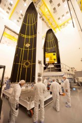
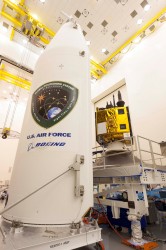
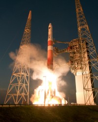
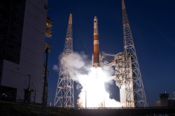
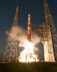
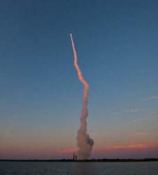
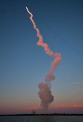
A United Launch Alliance (ULA) Atlas V rocket carrying the seventh GPS IIF satellite for the U.S. Air Force launched at 11:23 p.m. EDT Friday, August 1 (03:23 UTC, August 2), from Space Launch Complex-41 at Cape Canaveral, Florida.
GPS IIF-7 launches into orbit. (Photo credit: United Launch Alliance)
A United Launch Alliance (ULA) Atlas V rocket carrying the seventh GPS IIF satellite for the U.S. Air Force launched at 11:23 p.m. EDT Friday, August 1 (03:23 UTC, August 2), from Space Launch Complex-41 at Cape Canaveral, Florida.The Boeing-built satellite has sent the signals to controllers that confirm it is currently operating properly within the constellation.
Boeing and the Air Force will complete the full on-orbit checkout of the satellite in August. The GPS IIFs offer improved signal accuracy, better anti-jamming capability, longer design life and the new civilian L5 signal.
“We are providing our Air Force partner and GPS users with a steady supply of advanced GPS IIFs,” said Craig Cooning, president of Boeing Network & Space Systems. “Our robust launch tempo requires vigilance and attention to detail, and mission success is our top priority. We continue to partner with the Air Force and ULA to effectively execute the launch schedule.”
GPS IIF-7 is the seventh of 12 such satellites Boeing has built for the U.S. Air Force, and the third on-orbit delivery this year. GPS IIF-8, slated for launch during the fourth quarter, arrived at Cape Canaveral on July 16 to undergo final launch preparations. GPS IIF-7 will join a worldwide timing and navigation system utilizing 24 satellites in six different planes, with a minimum of four satellites per plane positioned in orbit approximately 11,000 miles above the Earth’s surface.
“Congratulations to the U.S. Air Force and all of our mission partners on the successful launch of the Atlas V carrying the GPS IIF-7 satellite,” said Jim Sponnick, ULA vice president, Atlas and Delta Programs. “ULA launch vehicles have delivered all of the current generation of GPS satellites, which are providing ever-improving capabilities for users around the world.”
This mission was launched aboard an Atlas V Evolved Expendable Launch Vehicle (EELV) 401 configuration vehicle, which includes a 4-meter-diameter payload fairing. The Atlas booster for this mission was powered by the RD AMROSS RD-180 engine, and the Centaur upper stage was powered by a single Aerojet Rocketdyne RL10A engine.
The EELV program was established by the United States Air Force to provide assured access to space for Department of Defense and other government payloads. The commercially developed EELV program supports the full range of government mission requirements, while delivering on schedule and providing significant cost savings over the heritage launch systems.
GPS IIF-7 launches into orbit. (Photo credit: United Launch Alliance)
According to Innovation editor Richard Langley, it appears that the satellite will be assigned PRN09, currently unused by the constellation.
The Initial NORAD 2-line element set indicates that the satellite has been launched into the F plane and is drifting towards its assigned orbital slot:
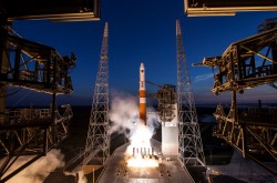
The GPS IIF-6 satellite was launched May 16. Photo credit: United Launch Alliance.
The Air Force is set to launch the seventh GPS IIF satellite this Friday.
An Atlas V 401 will launch the GPS IIF-7 mission for the U.S. Air Force on Friday, August 1, from Space Launch Complex (SLC)-41 at Cape Canaveral Air Force Station, Florida. The 18-minute launch window opens at 11:23 p.m. EDT.
A live webcast of the launch will begin at 11:03 p.m. EDT. To keep up to speed with updates to the launch countdown, dial the ULA launch hotline at 1-877-852-4321 or join the Facebook conversation and follow UA on Twitter using the hashtag #GPSIIF7.
GPS IIF-7 is one of the next-generation GPS satellites, incorporating various improvements to provide greater accuracy, increased signals, and enhanced performance for users.
The Air Force Second Space Operations Squadron indicates that IIF-7, SVN-68/PRN-3, will replace SVN-43 in the F plane slot 3 (F3). SVN-43 will be re-phased from F3 to the F2F slot to replace SVN-26. SVN-33 will be taken out of the operational constellation the day after SVN-68 launch and sent to Launch, Anomaly and Disposal Operations (LADO).
SVN-33 was launched on April 9, 1996, successfully serving over 17.5 years, 10.5 years beyond its design life. SVN-26 will back-up SVN-43 once it completes its re-phase journey.
At least some of the work on GPS III continues along prepared tracks, with the award of a Lockheed Martin contract to General Dynamics for two more satellites’ worth of communications hardware. General Dynamics Advanced Information Systems, a business unit of General Dynamics, was awarded a $25.4 million full-production contract from Lockheed Martin to support the GPS III Network Communications Element (NCE) for space vehicles seven and eight (SV 07-08). This commitment fills out that aspect of the current Lockheed Martin bevy of eight bought by the U.S. Air Force.
Many if not all components of the GPS III constellation beyond the Initial Eight have been called into question recently, with the U.S. Senate, the Air Force, and Lockheed itself keeping open minds about alternatives.
General Dynamics’ NCE components provide the communications functions for the GPS III satellites, including the ground-to-space command and control channel, the space-to-space inter-satellite channel and the command and telemetry communications channels within each satellite. General Dynamics is now under contract with Lockheed Martin for GPS III SV 01-08. Delivery of the NCE components for SV03 and SV04 are scheduled for this summer.
Compared to prior GPS vehicles, the Air Force’s GPS III satellites will deliver three times better accuracy, provide up to eight times more powerful anti-jamming capabilities and include enhancements that extend spacecraft life 25 percent further. GPS III-series satellites also will carry a new civil signal designed to be interoperable with other international global navigation satellite systems, enhancing civilian-user connectivity.
The majority of the work under contract will be performed at the General Dynamics Advanced Information Systems facilities in Scottsdale, Arizona, and Bloomington, Minnesota.
By Gerhard Beutler, Rolf Dach, Urs Hugentobler, Oliver Montenbruck, Georg Weber, and Elmar Brockmann
What Happened: On April 1, 2014, at 21:15 UTC, all GLONASS satellites started to transmit wrong Broadcast Messages (BM) as previously reported by GPS World. The satellite positions derived from these BM were wrong by up to ± 200 kilometers in each of the three coordinates x, y, and z of the Earth-fixed, geocentric, equatorial coordinate system. The problem disappeared after an hour (after two erroneous BM) for two GLONASS satellites; for other satellites, the problem lasted much longer: up to 10 hours. By about 07:30 UTC on April 2, the April Fools’ “joke” was over.
Effect on GPS/GLONASS Receivers
Essentially, we can distinguish two classes of receivers: those using the GLONASS BM for tracking and those not using them. The first class of receivers “became aware” of problems in real time, because GPS and GLONASS observations did not result in a consistent position estimation. In the best case, all affected GLONASS observations were flagged (and removed from further consideration) and the positioning worked properly with a reduced number of satellites. In the worst case, the receivers stopped tracking GPS and GLONASS satellites completely. The second class of receivers tracked GPS and GLONASS normally. The tracking problems created a major uproar in the user community of combined GPS and GLONASS receivers.
On June 3, 2014, at the 13th meeting of the U.S. National Space-based Positioning, Navigation, and Timing (PNT) Advisory Board, Gerhard Beutler, representing the authors of this article, delivered a presentation including an example of a permanent network of GPS and GLONASS dual-system receivers in Switzerland and neighboring countries, where about 40 percent of the approximately 60 receivers stopped tracking both GLONASS and GPS satellites. The malfunctioning receivers had to be reset manually on the morning of April 2 (for more information, see: www.gps.gov/governance/advisory/meetings/2014-06/beutler1.pdf).
Event as Viewed by the IGS
At first sight, the GLONASS April 1 and 2 event was actually a non-event for the International GNSS Service (IGS). The IGS is a voluntary federation of more than 200 worldwide agencies that pool resources and data from about 400 permanent GPS and GLONASS stations to generate precise GPS and GLONASS products.
The IGS product series, including precise GPS and GLONASS ephemerides, were generated as usual before, during, and after the event. On April 4, a quick analysis by Urs Hugentobler revealed that only the GLONASS BM were affected; the GLONASS code (pseudorange) and phase observations and the GLONASS satellite clock corrections, were not affected.
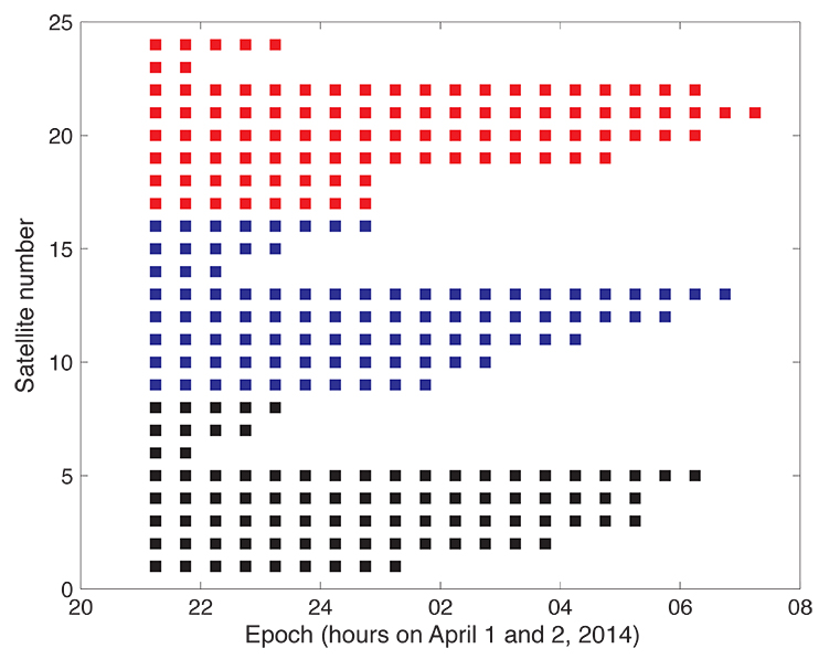
Figure 1 shows that the GLONASS event started simultaneously for all satellites (for stationary receivers, the first wrong positions were calculated for 21:00 UTC, based on the BM with Time of Clock (ToC) at 21:15 UTC). The problem was fixed for the first two satellites (the GLONASS satellites in orbital slots 6 and 23) one hour later; the last satellite wasn’t fixed until 07:30 on April 2 (using the correct BM at 07:45).
Figure 1. Affected broadcast messages for each GLONASS satellite. Colors indicate the different orbit planes.
More than 60 percent of the more than 200 combined GPS and GLONASS receivers in the IGS network tracked the GLONASS satellites normally. Fewer than 40 percent of the combined-constellation receivers had serious data outages (for GLONASS or even for both GLONASS and GPS). The number of GLONASS observations used in the daily work of the IGS analysis centers (ACs) was, however, only reduced by about 10 percent on April 2 (and even to a lesser extent on April 1). The small reduction is explained by the fact that only the last three and the first seven hours of April 1 and 2, respectively, were affected.
As the IGS ACs do not need the BM (neither for GPS nor for GLONASS), but may rather use their predicted orbits derived from the precise ephemerides of the preceding days, the number of good observations was still amply sufficient to calculate precise GLONASS orbits for April 1 and 2, essentially at the expected accuracy level.
Detailed Analysis
To further explore the structure of the problem, the BM-derived satellite positions were used as pseudo-observations in an orbit determination process. Orbit determination was successful when analyzing only “good” positions (prior to April 1, 21:00 or after April 2, 07:30). Orbit determination was successful, as well, when using only positions from “bad” BM. Successful means that the root-mean-square (RMS) error of the orbit determination process was of the order of about 0.5 meters per satellite coordinate — the expected order of magnitude.
As the bad satellite positions are now known to obey the laws of orbital motion, one may further investigate the nature of the differences between the “good” and the “bad” orbital positions. For that purpose, the precise GLONASS orbits of the IGS Center for Orbit Determination in Europe Analysis Center served as a reference. Its orbital positions were compared in the inertial coordinate system (one not rotating with the Earth) to the erroneous BM-derived positions by means of an orthogonal transformation, where only the three rotation angles around the x-, y-, and z-axes of the inertial equatorial coordinate system were estimated.
Table 1 shows that the positions derived from the normal (“good”) GLONASS BM compare very well to the IGS precise orbits. Except for a minor rotation about the z-axis, one obtains zero-rotations about the orthogonal axes in the inertial coordinate system.
Table 1. Rotation of the entire system of good orbit positions (April 1, 0:00 – 20:45 UTC) with respect to precise IGS reference orbits (“good” BM) and rotation of the entire system of bad orbit positions (April 1, 21:00 – April 2, 07:00 UTC) with respect to precise IGS reference orbits (“bad” BM).
Table 1 also shows that the “bad” positions were obtained from the reference positions by a rotation of about 0.5 degrees around the inertial x-axis. The RMS of 71 meters should be compared to the entire effect of up to 200 kilometers per coordinate. Comparing this RMS of 71 meters with the RMS of the orbit determination of about 0.5 meters per coordinate also says, however, that the “true” transformation is more complicated than one represented by just a series of three rotations.
We did not further investigate how this more or less consistent rotation could enter into the GLONASS BM. It seems to be clear, however, that a systematic error slipped into the realization of the GLONASS BM, which were activated at a common reference epoch for all satellites (but uploaded to individual satellites at different times).
Figure 1 suggests that the problem was almost immediately recognized by GLONASS operators: already an hour later the first two satellites started to transmit BM with the usual accuracy level.
Figure 1 also supports the idea that the problem was remedied satellite-by-satellite. A back-of-the envelope calculation revealed that the satellites were above the horizon of at least one of the Russian uplink sites at the times of switching back to the correct BM.
Summary and Conclusions
The GLONASS event was one that we might have described by the phrase “such a thing can never happen.” For the user community, the situation was aggravated by the fact that the event was not reported through the official Russian channel by issuing a Notice Advisory to GLONASS Users (NAGU). This definitely should have happened in the interest of transparency.
The above analysis was based on information available through the IGS. It was performed weeks after the event. It is worth noting, however, that the information needed for the analysis was available in real time. The reference orbit used in the analyses could have been replaced by the IGS predicted orbits generated in the ultra-rapid series.
In view of the importance of BM for all users and in particular for the users of IGS real-time products, the IGS might consider monitoring the quality of BM for all GNSS.
Fixing the GLONASS Bug: Report from Moscow
In a May 23 conversation with journalists, Javad Ashjaee, president of JAVAD GNSS, decried the recent controversy about monitoring stations on both U.S. and Russian soil, saying it was based in misinformation and misinterpretations, inflated by a political crisis. He also supplied a different perspective on the GLONASS signal outage than has been reported in other media outlets.
“There was speculation in early April that it took GLONASS 11 hours to correct a software bug because it took that long for all the satellites to pass over a control station on Russian soil. This was not the case, I have learned from conversations with their engineers and with the head person responsible for all of this. One engineer made a mistake and uploaded the wrong software. Until they could find it and debug it — and it took them 11 hours to do so — they could not upload correct software to the satellites.
“The 11-hour outage was not due to a wait for all satellites to pass over ground control stations on Russian soil to receive a fresh upload of data,” continued Ashjaee. “GLONASS has the capability, like GPS, to make updates via inter-satellite communication. The delay was caused by the time it took to find the bug in the erroneous software that had been uploaded and correct it.”
Ashjaee addressed the monitoring station controversy, saying that Russia had sought GLONASS monitoring stations in the United States, not for uploading any data, but for monitoring GLONASS satellites to provide more accurate orbit and clock information, for the free benefit of all users.
A single GLONASS-M satellite was launched from the Plesetsk Cosmodrome on June 14. GLONASS-M 55 (with designation 755 once operational and also known as Kosmos 2500), was inserted into the constellation’s Plane 3 and will occupy orbital slot 21.
Manufacturer Reshetnev reported that the satellite is equipped with an experimental payload capable of transmitting signals in the L3 frequency band. The L3 signal, centered at 1202.025 MHz , is CDMA unlike the GLONASS legacy FDMA signals. The experiment will include flight testing of the new equipment and evaluation of its accuracy characteristics. The GLONASS-K1 test satellite also transmits an L3 signal.
European Space Symposium: Digest
Copernicus, “the younger brother of Galileo,” will be the main implementation of Galileo and other GNSS technologies going forward in Europe, according to to Paul Weissenberg, EC deputy director general for enterprise and industry. An Earth-observation satellite program administered by the European Space Agency to provide accurate and timely information to improve the management of the environment, understand and mitigate the effects of climate change, and ensure civil security, Copernicus was previously known as the Global Monitoring for Environment and Security (GMES).
Sliding to the Right. Galileo will make its “early-service declaration in the first half of next year,” said Matthias Patschke, director of EU satnav programs. This appears to back off slightly from previous dogged determination to declare services before the end of 2014.
The EC may propose legislation to make mandatory the use of GNSS technology in different areas: as with eCall, starting in 2015, including Galileo in the receivers inside cars, according to Marian-Jean Marinescu, member of the European Parliament.
Peter Large of Trimble spoke out against the mandating of a specific GNSS use in any market: “A bad policy outcome that moves backward into regionalization.”
The U.S. Air Force is shopping for alternative companies to head the GPS III program after its current contractor, Lockheed Martin Space Systems, hit production delays, according to the Denver Post.
There have been technical problems with the first GPS III satellite navigation system, which is supplied by Lockheed Martin subcontractor Exelis, the newspaper reports.
After the current eight-satellite contract is fulfilled, contracts to build the 22 remaining spacecraft are up for bid, according to a notice posted by the Air Force on the Federal Business Opportunities website.
Exelis’ navigation system was producing signal interference that prevented Lockheed from delivering by its target date earlier this year, which is now anticipated for delivery in 2015. The system is undergoing rigorous tests.
Friday’s launch of a Delta 4 rocket carrying the latest GPS satellite was tracked via GPS itself instead of by radar, reports Spaceflight Now in an article.
United Launch Alliance’s Atlas and Delta rockets are transitioning to GPS metric tracking for range safety functions, which protect the public and property should a launch vehicle veer off course. The move is a money-saving upgrade to the military’s aging range infrastructure.
A special avionics system on the launcher transmitted the location. For decades, most rockets launching from Cape Canaveral, Florida, and Vandenberg Air Force Base, California, have been tracked by C-band radar.
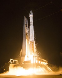
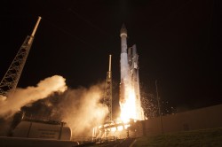
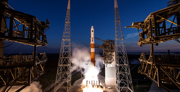
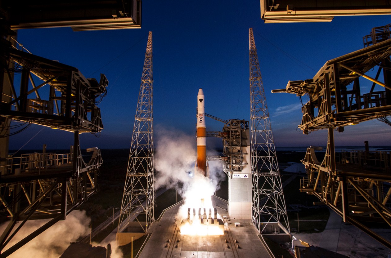
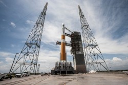
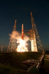
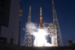
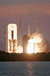
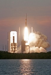
The sixth GPS Block IIF satellite was successfully launched Friday at 8:03 p.m. local time. Built by Boeing Space and Intelligence Systems of El Segundo, California, GPS IIF-6 launched aboard a United Launch Alliance Delta 4 rocket from Cape Canaveral Air Force Station in Florida.
The launch was originally planned for Thursday evening, but bad weather led to a 24-hour hold. One hour remained in the countdown when the launch was scrubbed.
Two more GPS IIF satellites are scheduled to launch before the end of the year.
Below is a video of the launch.
Here are launch highlights.
This patch commemorates the launch of GPS IIF-6, nicknamed Rigel.
GPS IIF-6 is nicknamed Rigel. All of the Block II-F satellites have been named after stars. Rigel is is the brightest star in the constellation Orion and the seventh brightest star in the night sky, with a visual magnitude of 0.12.
In the patch commemorating the launch, Orion is depicted with an alligator head. This is in reference to the “Night Gators,” the part of the launch team that is responsible for moving payloads to the launch pad, which has typically occurred at night.
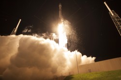
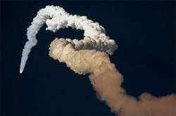
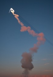
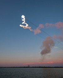
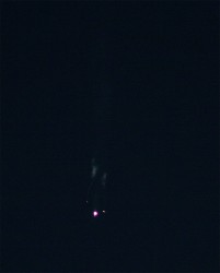
A slideshow of photos from United Launch Alliance:
The ULA Delta 4 rocket blasts off at sunset from Cape Canaveral’s Complex 37 on a mission to deploy the GPS IIF-6 satellite. Photo credit: Spaceflight Now.
Photo credit: Spaceflight Now.
Photo credit: Spaceflight Now.
Photo credit: Spaceflight Now.
Photo credit: Spaceflight Now.
Photo credit: Spaceflight Now.
Photo credit: Spaceflight Now.
Photo credit: Spaceflight Now.
Photo credit: Spaceflight Now.
Photo credit: Spaceflight Now.
Innovation Editor Richard Langley helped compile this report.