User equipment incorrectly interpreting data from a satellite set “unhealthy” led to an apparent constellation outage for roughly 1,000 fleet vehicles across Australia in April. The problem was traced to the way a GPS/telecomm chip reacted to an extended navigation test aboard SVN-49, having to do with the recently launched IIF satellite, SVN-64.
Although SVN-49 was set unhealthy at the time, the integrator-equipped fleet vehicles across the continent experienced periods of several hours without satellite visibility, in unobscured environments.
The U.S. Air Force GPS Operations Center reported that in mid-May tests, “PRN 30 [was] broadcasting almanac datasets that do not reflect constellation changes that occurred since it was last uploaded with navigation message data. [. . . ] The utilization of these almanacs in a manner that regards the time of week, but neglects or mishandles the week number (effectively executing as if the current week number is the week number associated with these almanac parameters), will result in an increasing error in visibility determination and other almanac based estimations (elevation/azimuth, Doppler shift, SV clock offset from GPS time, etc) as the dataset’s actual week offset from the current week increases.”
The situation occurred once previously, in 2011 with Mercedes in Europe. The problem was traced to chips from the same manufacturer, installed by the car-maker’s integrator partner, also misinterpreting data from a satellite set unhealthy while broadcasting system test data.
Update: The launch of the GPS IIF-6 satellite has been delayed one day due to bad weather.
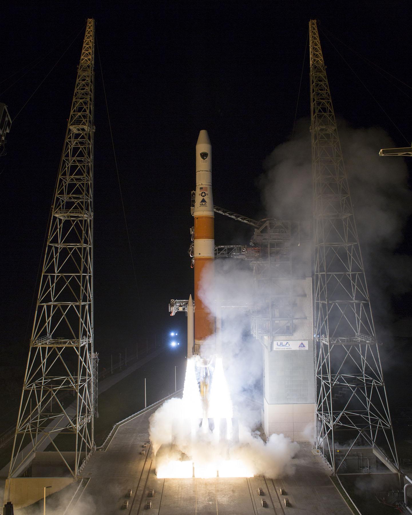
Another GPS IIF satellite is expected to lift off aboard a United Launch Alliance Delta 4 rocket from Cape Canaveral at 8:08 p.m. EDT May 15 at the opening of an 18-minute launch window.
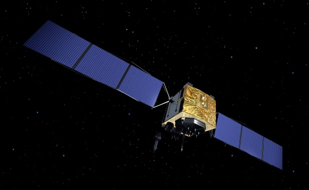
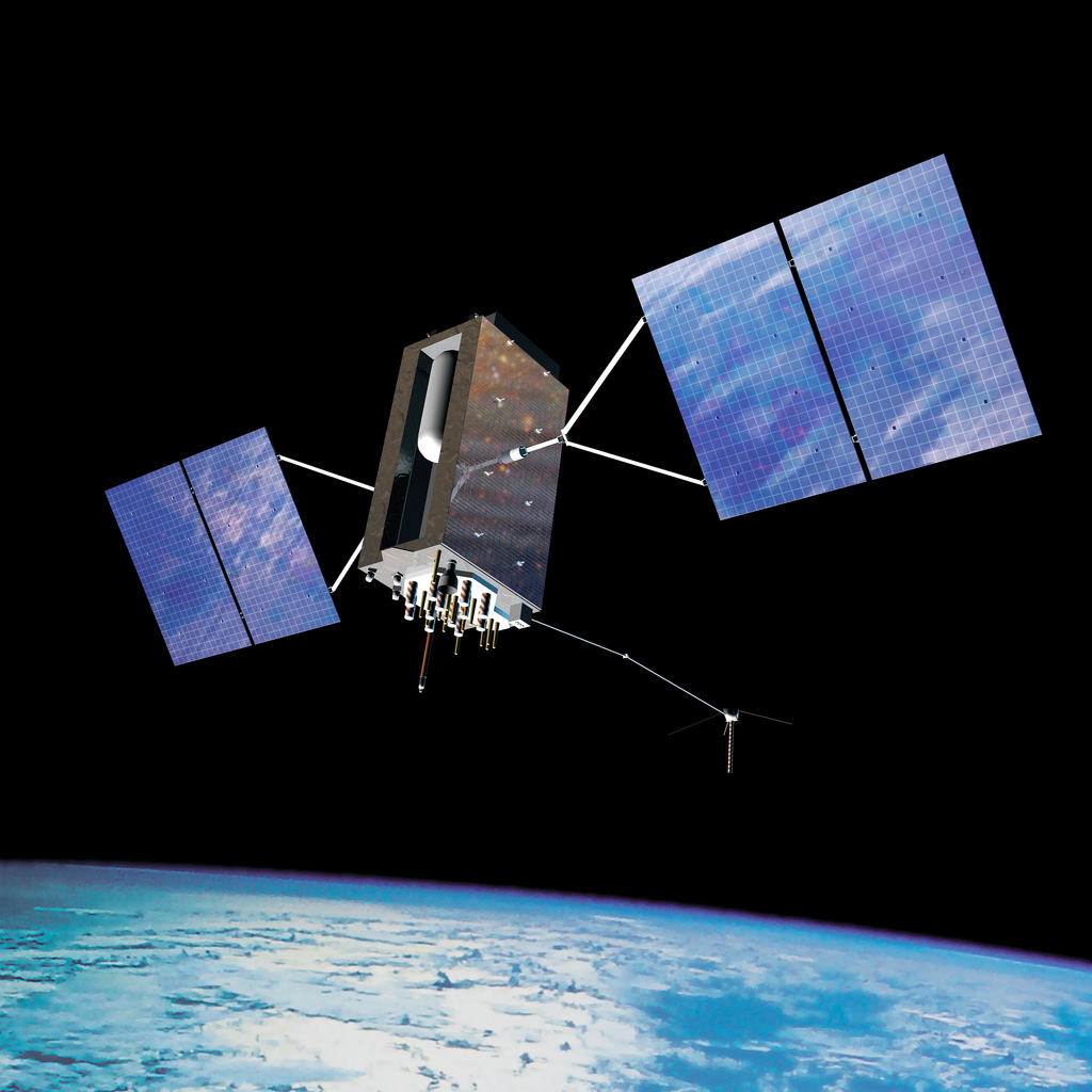
The satellite, designated GPS IIF-6 and built by Boeing, is one of the next-generation GPS satellites, incorporating improvements to provide greater accuracy, increased signals, and enhanced performance for users. According to Boeing, each GPS IIF satellite has:
greater navigational accuracy through improvements in atomic clock technology.
a new civilian L5 signal to aid commercial aviation and search and rescue operations.
improved military signal and variable power for better resistance to jamming in hostile environments.
a 12-year design life providing long-term service and reduced operating costs.
an on-orbit, reprogrammable processor that can receive software uploads for improved system operation.
GPS IIF-6 will be the United Launch Alliance’s fifth launch of 2014 and 82nd overall. It also will mark the 26th flight of the Delta IV launch vehicle since its inaugural flight in November 2002.
GPS IIF-5 was launched on February 20 and turned over to the 2nd Space Operations Squadron (2 SOPS) for operations on March 5. This was the 10th successful launch and initialization using Braxton Technologies‘ Launch, Anomaly Resolution, and Disposal Operations (LADO) system.
LADO has performed all the mission planning, commanding and telemetry processing necessary to prepare all GPS satellites for operational use since October 2007. Developed and sustained by Braxton Technologies, LADO was built using Braxton’s ACE Premier commercial-off-the-shelf (COTS) product line for spacecraft control, astrodynamics and simulation.
“Braxton is proud to be a key partner on the GPS program,” said Ken O’Neil, Braxton’s President and Chief Operating Officer. “As a small business, we greatly value our partnership with the US Air Force and enjoy quickly delivering innovative capabilities to support the U.S. military and the GPS worldwide user community.”
The GPS IIF-5 replaces the GPS IIA-15 satellite launched in 1994. The 19th Space Operations Squadron (19 SOPS) will control the GPS IIA-15 using LADO, where the spacecraft will be stored as a spare available for reactivation within the x-plane for the remainder of its useful life.
A United Launch Alliance Delta IV lifts off from Space Launch Complex-37 with the Air Force’s Global Positioning System (GPS) IIF-5 satellite. This launch marked the 25th Delta IV flight since the first flight in 2002.
The latest GPS Block IIF satellite, IIF-5 or SVN64 (operating as PRN30), was launched on February 21, 2014. Typically, GPS satellites are checked out and made operational within about a month following launch. SVN64 has yet to be set healthy.
The delay is due to an extended navigation test being performed by the GPS master control station. A navigation upload for SVN64 was performed in March with ephemeris and clock data as usual streching weeks in advance. However, unlike with operational satellites, no further updated uploads have been performed. The aging ephermis and clock data gradually becomes less and less accurate as time goes by but should degrade gracefully.
Inquisitive observers will have noticed that the received navigation data from SNV64 changes infrequently. Currently, the navigation data changes once per day with an epoch of 13:00 GPS Time unlike every two hours with operational satellites. And the data fit interval is 26 hours, compared to four hours.
Calling it an “unprecedented and deeply worrying total disruption . . . [that] shook the industry,” Locata Corporation reiterated its call for redundant terrestrial systems to back up GNSS in the wake of the April 1 11-hour GLONASS system outage.
Nunzio Gambale, Locata CEO, said “We have been telling the industry for years that you cannot have a critically important capability like GPS without also having a backup! What is Plan B if the satellite systems fail? What replaces the space signal when there is a problem? If anyone needed a sign to understand why Locata has spent years inventing and developing the world’s first local terrestrial equivalent of the GPS system, then last week’s meltdown of a complete global satellite navigation system is it. This event should terrify every nation, government, and company that depends on navigation satellites for their business or, in some cases, their very lives.”
The navigation and timing functions of the global positioning systems underpin the world’s banking systems, stock exchanges, digital TV and Internet, cell phone networks, and, in some cases, the national electricity supply, Locata pointed out. GPS, in particular, plays a crucial role in transportation, shipping, and logistics, serving as the enabling technology for critical functions like air traffic control. Reliability is therefore not just important; it is essential across all applications. Locata, the Resilient Navigation and Timing Foundation (RNTF) in Washington, D.C., and others have persistently called attention to the need for redundant terrestrial systems that will back up expensive, vulnerable, and aging global satellite navigation constellations while simultaneously providing the local control and resiliency that satellite-based systems cannot deliver.
Professor Chris Rizos of the School of Civil and Environmental Engineering at the University of New South Wales stated that “This catastrophic failure of one of the world’s two global satellite navigation constellations is a wakeup call for all of us. We ignore the possibility of these ‘Black Swan’ events at our own peril.”
The GLONASS disruption was felt around the world, immediately upon its origination, especially in professional applications, such as tractor automation for farming, machine control and robotics in mining and heavy industry, and in the national infrastructure used by surveyors and industry across many countries.
“This shows just how interlinked the physical and cyber worlds have now become,” added Professor Brett Biddington, a space and cybersecurity expert from the School of Computer and Security Science at Edith Cowan University, Australia. “The prospect of a software glitch, whether unintentional or intentional, seems highly likely [as a cause for the failure]. If it was a deliberate attack, however, it points to a changing face of warfare where the real enemy may be impossible to detect and deter until very damaging strikes, such as an attack on the GPS system, have already taken place.
“The vital point here is that this is no longer just a question for scientists and technologists. A locally controlled backup system for this essential signal is a national policy question of the highest order.”
Locata Corporation and other industry authorities have long testified on global satellite navigation vulnerabilities and the need for diverse technology options to strengthen and back up GPS, GLONASS, and other systems. Locata developed a robust solution and has been awarded a sole-source contract by the U.S. Air Force (USAF) to provide its terrestrially based alternative positioning for military applications where GPS has been completely jammed. The first wide-area Locata system is being deployed now at the White Sands Missile Range in New Mexico. The USAF demonstrated that the White Sands Locata network delivers what has been extremely high accuracy over a 2,500-square mile area, positioning aircraft flying up to 35 miles away to an accuracy of better than six inches.
A pair of LocataLite transmit antennas overlook a section of the White Sands Missile Range blanketed by the Locata high-precision ground-based positioning system.
“There is no other technology that can do this, and it’s delivered in the complete absence of GPS,” continued Gambale. “What is being demonstrated at White Sands is that Locata supplies precisely the same function as GPS, even when there is no GPS available. That’s exactly what you need if the satellites fail.
“If this event had been a GPS failure instead of a GLONASS failure – and it could very easily have been – then the entire world would have plunged into a catastrophe. This event is the navigation equivalent of a ‘close call moment,’ and from here on out no one can even question that this is a really serious problem that must be addressed. Another industry expert recently told me, ‘If there was a sustained GPS outage, it would cause a global financial nuclear winter from which it would take us decades to recover.’”
Gambale concluded, “We need action to develop local backups like Locata around places like airports and other strategically important areas – now! We must not wait until we are faced with another seemingly impossible event like a complete satellite constellation failure. We may not dodge this bullet a second time.”
Locata terrestrial positioning technologies complement GPS by setting up ground-based transmitters, called LocataLites, to create a local constellation called a LocataNet. Once properly deployed, Locata’s unique nanosecond-accurate TimeLoc system synchronizes the network, which allows it to replicate the positioning capabilities of GPS, locally. LocataNets operate today in environments ranging from small warehouses to open-cut mines, wide-area aircraft approach-and-landing systems, and wider areas for aircraft and unmanned aerial vehicle (UAV) uses.
Signs Point Toward Early Services in December, If ESA Delivers
Europe’s Galileo satnav system.
A February conference on the European Union’s space policy in Brussels sought to set a course for 2020 and close official ranks behind the prospect of early Galileo services at the end of this year. Much in the business community’s perception of the new system — critical for device availability and mass- and professional-market adoption of Galileo — will depend on meeting the projected unveiling of early services in December. This is turn depends on an operational 10-satellite constellation; the fleet now stands at four.
Among trends noted at the meeting: the growing importance of the European GNSS Agency (GSA) as Galileo service provider, with perhaps more authority — and budget — than it has had in the past to get the job done. “The GSA will gradually assume responsibility for the operational management of the programmes while ESA will remain responsible for the deployment of Galileo, and the design and development of new generation of systems,” announced the European Commision (EC).
EC Vice President Antonio Tajani reiterated there will be three Galileo launches in 2014 to reach the requisite year-end total. “The first will come in June. Two satellites have passed the necessary tests. We need to keep this up, and continue to raise our game.”
Trouble on the Equator. The next two Galileo satellites may be ready to ship to Europe’s spaceport in South America by early April. But a large European commercial satellite customer is crowding the schedule, pressuring launch operator Arianespace to lift its satellites first. This could delay the Galileo birds, now set for June rise.
ESA’s year-end plan calls for two more dual-satellite launches in October and December on Russian Soyuz rockets — new partners to the Galileo dance, bringing perhaps new technical connectivity issues.
It’s Not Easy. With Galileo and EGNOS financed to the tune of €7 billion for 2014–2020, expectations are high, yet the European Commission brings a decidely conservative approach to expenditure on new ventures.
“To take a chance, to do what no one has ever done — it’s not easy in a culture that doesn’t like risk,” said ESA director Jean-Jacques Dordain.
Other conference speakers pointed to the securely established European Geostationary Navigation Overlay Service (EGNOS), the first generation of Europe’s GNSS, now fully operational.
Carlo des Dorides, executive director of the GSA, responsible for operating EGNOS through the EGNOS Service Provider (ESSP), elaborated on his big job in 2014: maintaining and improving EGNOS performance and maximizing user adoption, particularly in the aviation, maritime transport, and rail transport sectors.
“The experience we gain through our work with EGNOS will be instrumental as we move towards Galileo service delivery.”
As well as organizational experience with EGNOS, user adoption of the GNSS precursor augurs much for Galileo. With one eye on the present and another on the future, the GSA has a big serving coming to its plate by December: management of a long-awaited, heavily invested system that has been in discussion since the 1990s and in various stages of gestation since 2000.
PNT Advisory Board Hears Air Force CNAV Plan
The U.S. National Space-Based Positioning, Navigation, and Timing (PNT) Advisory Board published the minutes of its December 2013, detailing a report from Air Force Space Command on the road ahead for implementation of the GPS Civil Navigation (CNAV) message on L2C and L5. The subject has stirred some controversy of late, particularly between the U.S. Departments of Transportation (DoT) and Defense (DoD), and DoT is currently seeking public comments on the plan.
The minutes relay the gist of General Whelan’s CNAV remarks as follows: “CNAV has been under discussion for a considerable time. Currently, L2C and L5 signals are being transmitted, but without a navigation message. AFSPC is working hard to activate these messages as soon as possible. One of the reasons for the delay is that additional time was needed to complete testing prior to activation. Testing began in late summer 2013 and, based on initial test results, a ‘way ahead’ has been plotted. . . . Current plans are to begin initial broadcasting in the spring of 2014. CNAV uploads will occur twice weekly. The signal will meet GPS Standard Positioning System (SPS) standards, but may not achieve current accuracy levels until full implementation in late 2014.
“CNAV live-sky testing occurred in June [2013] and was conducted in cooperation with civil, industry, and international partners. The two-week test series included independent assessment and verification. The tests identified four errors that required action. The first, which was addressed in real time, related to implementation of the test series. The second required improvement to the tools suite, which should be totally integrated into the ground segment by December 2014. The third and fourth errors required patches to satellite software. All four issues are now regarded as closed.”
DOT Speaks. A subsequent presentation from the Department of Transportation did not directly mention CNAV, according to the meeting minutes, but did include this update on civil signal monitoring, taken from the meeting minutes:
“DOT is responsible for performance monitoring of GPS civil signals. The International Committee on GNSS’s (ICG’s) transparency principle states that ‘Every GNSS provider should publish documentation that describes the signal and system information, the policies of provision, and the minimum levels of performance offered for its open service.’
Currently, this is only done on GPS L1 C/A signals. Performance standards for L2C and L5 have not yet been established. The crucial function of signal/service monitoring is to verify that commitments to GNSS performance are being met. Additionally, monitoring improves the situational awareness for GNSS operators, and provides assurance that any civil service failure is detected and resolved promptly.”
Opposing Activation. At the close of 2013, a departing DOT assistant secretary wrote a letter to the Air Force opposing activation of the CNAV signal in April 2014. In March, DOT opened a 30-day comment period on the proposed CNAV message on L2C and L5. The comment period closed on April 4, after press time for this magazine so no results are yet known.
Bright New IIF Aloft
A United Launch Alliance Delta IV lifts off from Space Launch Complex-37 with the Air Force’s Global Positioning System (GPS) IIF-5 satellite. This launch marked the 25th Delta IV flight since the first flight in 2002.
The latest GPS IIF satellite was successfully launched into orbit on February 21. GPS IIF-5 will replace the vintage 1997 spacecraft known as GPS IIA-28 in Plane A, Slot 3 of the constellation. IIA-28 will go into a reserve role in the network for the remainder of its useful life.
This is the first of three GPS launches planned through July to replace aging craft in the constellation. The IIF generation will form the backbone of the GPS space fleet for the next 15 years, providing greater navigational accuracy through improvements in atomic clock technology, a new, more robust, third civil signal, L5, for commercial aviation and safety-of-life applications, a second civil signal, L2C, for the dual-frequency GPS receivers, and improved anti-jam capabilities for military and civil users around the world.
The GPS Block IIF satellites are built by Boeing. Earlier IIF satellites were launched in 2010, 2011, 2012, and 2013. All 12 satellites in the GPS IIF series have completed production. The Air Force plans to launch the remaining IIF satellites by 2016.
Downstream Dialog, Tests in Europe
With Galileo services set to take effect in December, the two European entities charged with the program are engaging manufacturers — the European Space Agency (ESA) in consumer markets, and the European GNSS Agency (GSA) in the government security sector, respectively.
“We put out an open call to satnav manufacturers offering testing with our laboratory facilities,” said the head of ESA’s Radio Frequency Systems, Payload, and Technology Division. “We have gone on to work with five mass-market chipset makers and a comparable number of professional receiver manufacturers.”
Available ESA facilities include:
a hybrid localization solution rack for receiver plug-in; it generates simulated constellations of multiple satnav systems along with Wi-Fi or mobile networks. It can also simulate inputs from inertial devices.
the octobox, a mini anechoic chamber into which phones or mobile devices can be placed, to feed them simulated satnav and cellular network signals.
a telecommunications and navigation testbed vehicle for field tests, carrying its own extremely accurate receivers to assess the performance of the consumer devices under test.
“Thanks to earlier collaboration with ESA and the EU, the millions of multi-constellation satnav chips we sell annually have been equipped for Galileo signals since 2009,” stated Philip Mattos of ST Microelectronics, whose Teseo II receiver chips are used in satnavs and embedded in cars (see detailed technical article on page 36). “It will take only a software update to enable them to start using Galileo. This cooperation allows us to optimize our software based on access to actual signals and background technical information.”
Regulated Service. The GSA invited European industries and member states’ Public Regulated Service (PRS) authorities to share views and ideas on technologies at the user segment level for the adoption of the PRS. The PRS uses encrypted signals designed to resist jamming, involuntary interference, and spoofing. GSA’s objective is to ensure that PRS service is affordable and secure for all interested users while also ensuring that European industry maintains its competitive edge in the global satellite navigation marketplace.
GSA consultations will focus on:
steps transforming technologies into products competitive enough in terms of cost, power, dimension;
euro-manufacturing capability and capacity, especially nanotechnology;
how to build the manufacturing lines capable of serving PRS user segment needs;
main domains, elements, and interfaces that will benefit from standardization, allowing for a stronger market adoption of PRS.
GPS III Alternative Payloads Canvassed
GPS III prime contractor Lockheed Martin has heard from six companies concerning alternate designs for the GPS III satellite payload, according to reports. A company spokesperson said “constantly canvassing the industrial base to see what’s out there” is merely part of Lockheed’s standard business practice.
Lockheed Martin partner Exelis Geospatial Systems currently supplies the payload, as it has for all previous GPS generations. Earlier this year, Gen. William Shelton, Air Force Space Command, said the first GPS III launch date had slipped from late 2015 into 2016, and confessed to “patience wearing thin” at a press breakfast.
Part of the delay may have been due to signal crosstalk in the new, as yet unlaunched, payload. Crosstalk occurs when a signal broadcast on one circuit creates an undesired effect on another circuit.
The Story So Far. In December 2013, Lockheed Martin turned on power to the bus and network communications payload of the second GPS III satellite, SV-02, at its test facility in Denver. This demonstrated the satellite’s mechanical integration, validated its interfaces, and opened the way for electrical and integrated hardware-software testing. The first GPS III satellite (SV-01) was powered on in February 2013.
In October, the Lockheed Martin GPS III Nonflight Satellite Testbed (GNST), a full-sized, functional satellite prototype at Cape Canaveral Air Force Station, successfully communicated via cross-links to Air Force simulators of the current GPS constellation in orbit. Testing also demonstrated the ability of an Air Force receiver to track navigation signals transmitted by the GNST.
Exelis Advances. In mid-March, Exelis announced successful completion and full testing of six transmitter assemblies, which are integral payload components for the GPS III satellites. The test program includes random vibration, pyroshock, and thermal vacuum testing, replicating space-like conditions through deployment and on-orbit environments. In January, Exelis received three rubidium atomic frequency standard clocks from Excelitas Technologies specifically designed for GPS III.
Next-Gen SBAS Will Be a Multi-Constellation Affair
Plans to harness Galileo and other satnav systems for next-generation satellite augmentation systems for aviation and other high-performance uses took a step forward at the 126th Satellite-Based Augmentation Systems (SBAS) Interoperability Working Group (IWG) in New Delhi, India, in February, with plans to move to a multi-constellation design adding Galileo, BeiDou, and GLONASS systems in the post-2020 era.
International experts began converging on a standard message definition for the L5 channel of the planned second-generation SBAS systems, which will utilize dual-frequency, multi-constellation signals.
“Two solutions had been put forward, one by ESA based on work by European industry and one from the U.S. Federal Aviation Administration and Stanford University,” explained ESA’s Didier Flament, co-chair of the IWG.
“A single definition coordinated between both bodies has been presented, combining the benefits of both solutions. The formal IWG review and approval loop has now been started with the objective of finalizing it for September’s IWG meeting.
“The aim is to have it ready to submit to the official international SBAS standardization bodies — the International Civil Aviation Organization and the Radio Technical Commission for Aeronautics — as soon as October.”
GAGAN to the Mix. The meeting also marked the significant progress made by India’s own SBAS system GAGAN, which underwent its final stability test in summer 2013, followed by its safety certification in December.
At this point GAGAN was declared certified for non-precision approach users , followed by its safety-of-life service being formally offered to civil aviation users on February 14.
SBAS Services Worldwide
GAGAN is the fourth certified SBAS to enter service worldwide. Europe has the European Geostationary Navigation Overlay Service (EGNOS), which was designed and built by ESA then turned over for operation by the European Satellite Service Provider, ESSP, overseen by the European GNSS Agency (GSA) — both of whom also participated in the meeting. ESA retains responsibility for the future evolution of EGNOS.
The U.S. has the Wide Area Augmentation System (WAAS), developed and operated by the Federal Aviation Administration, with an extension over Canada called CWAAS (Canadian WAAS). WAAS celebrated its 10th anniversary of operational life in July 2013.
Japan has the Multi-functional Satellite Augmentation System (MSAS), developed and operated by Japan’s Civil Aviation Bureau. Japan is discussing plans to merge this capability with its new home-grown satnav system, QZSS.
Along with GAGAN, the meeting covered the progress made by the other SBAS systems under definition or development — the Russian SDCM, Chinese SNAS, and Korean K-SBAS.
The next IWG meeting will take place in September in Tampa, Florida.
Nucleus of Four Now Operational: It “Works, and Works Well”
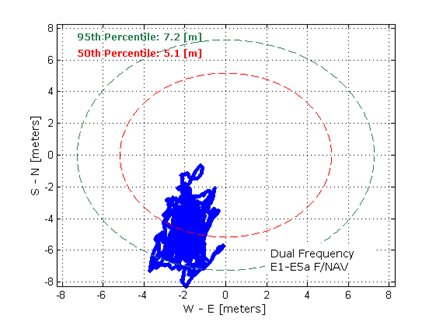
Dual-frequency Galileo positioning performance during the In-Orbit Validation phase: positioning accuracy is an average 8 m horizontal and 9 m vertical (95% of the time). Its average timing accuracy is 10 nanoseconds on average. Plot courtesy of ESA.
“IOV was required to demonstrate that the future performance that we want to meet when the system is deployed is effectively reachable,” said Sylvain Loddo, ESA’s Galileo Ground Segment manager. “It was an intermediate step with a reduced part of the system to effectively give evidence that we are on track.”
Following a March 2013 first determination of a ground location, jointly by Galileo’s space and ground segments, program managers undertook a wide variety of tests all across Europe.
“More than 10,000 kilometers were driven by test vehicles in the process of picking up signals, along with pedestrian and fixed receiver testing. Many terabytes of IOV data were gathered in all,” said Marco Falcone, ESA’s Galileo System manager.
According to ESA’s elaboration on the test results, the system has proved itself capable of solely performing positioning fixes across the planet.
Galileo’s observed dual-frequency positioning accuracy is an average of 8 meters horizontal and 9 meters vertical, 95 percent of the time. Its average timing accuracy is 10 billionths of a second. Its performance is expected to improve as more satellites are launched and ground stations come on line.
For Galileo’s search-and-rescue function — operating as part of the existing international Cospas–Sarsat programme — 77 percent of simulated distress locations can be pinpointed within 2 kilometers, and 95 percent within 5 kilometers. All alerts are detected and forwarded to the Mission Control Centre within a minute and a half, compared to a design requirement of 10 minutes.
“Europe has proven with IOV that in terms of performance we are at a par with the best international systems of navigation in the world,” said Didier Faivre, ESA director of Galileo and Navigation-related Activities.
Historically Speaking. In a February 2013 GPS World article, Peter Steigenberger, Urs Hugentobler, and Oliver Montenbruck discussed Galileo-only positioning. “Using an ionosphere-free dual-frequency linear combination of pseudorange measurements on the Galileo E1 and E5a frequencies, the position of the TUME reference station [at the Technische Universität München (TUM) in Munich, Germany] could be determined with a 3D position error of less than 1.5 meters,’” the authors said.
Crystal Ball Gazing. The next two Galileo satellites, of the full operational capability (FOC) class, currently complete their testing for flight clearance at ESA’s ESTEC facility.
Six such satellites are destined to rise into space in 2014, according to ESA’s master plan. Should all those launches occur as scheduled, Galileo’s initial services could start by the end of the year.
GNSS Vulnerable: What to Do?
Too Much Sensitivity, Not Enough Robustness, Says Parkinson
Brad Parkinson, the founding architect of GPS, told a UK conference that the system needs to be made more robust to ensure worldwide availability of services to users. His concerns over GPS availability relate to threats such as the loss of authorized frequency spectrum (implicitly creating licensed jammers), space weather due to hyperactive ionospheric conditions, and deliberate or inadvertent jamming of GPS signals.
He warned that GPS is more vulnerable to sabotage or disruption than ever before, and charged that politicians and security chiefs are ignoring the risk. Western governments are “in their infancy in recognizing the problem,” he remarked further in an interview with London’s Financial Times. “[In the United States] I don’t know anyone that is really in charge of it. The Department of Homeland Security should be [but] … they don’t have any people that understand it very well. They’ve got one person without any budget to speak of.”
He also warned that Europe’s €5 billion Galileo system is equally at risk.
Parkinson proposed a three-stage program to:
Protect (legally) the signal and physically eliminate jamming sources;
Toughen the GPS/Galileo receiver’s resistance to interference;
Augment the GPS signals with other satellites or with ground-based transmitters such as eLoran.
To support his proposal, Parkinson stated, “The number one need for all GPS or Galileo users is availability. Over the years, manufacturers of signal receiver technologies have focused too much on sensitivity and not enough on resilience or robustness. The maritime industry is a particular concern where users have taken GPS for granted. They must increase preparedness and backups as they do in aviation or other GNSS-using industries.
“Even today, most ships have only GPS and the vision of their crew to guide them when approaching harbors. As you can see from today’s conference, there are a wealth of solutions to toughen and back up GPS, many of which are not technologically difficult nor expensive, but still their adoption in sectors such as global shipping is certainly not adequate.”
As part of his protection program, Parkinson urged that penalties for jamming GPS networks be coordinated worldwide. “In Australia, if you cause interference likely to cause prejudice to the safe conduct of a vessel, it’s five years in the jug [jail] and $850,000.” Contrasting this with a U.S. case that may simply impose a forfeiture of the culprit’s jamming device, Parkinson added, “I’m calling for the community of nations to move to the Aussie-type penalties.”
In the toughening regard, Parkinson alluded to integration of GPS data with information derived from an inertial positioning system. “If you combine all of these things, a good set should be able to fly within 1 kilometer of a jammer with a 10-kilometer range,” said Parkinson. “That’s what I call toughening.”
Parkinson made his remarks as the keynote speech at GNSS Vulnerabilities and Resilient PNT 2014, hosted by the Royal Institute of Navigation. He will also deliver the keynote address, “Assured PNT: Assured World Economic Benefits,” for the European Navigation Conference on April 15 in The Netherlands.
Russia will deploy as many as seven ground monitoring and augmentation stations for GLONASS outside its national boundaries. GLONASS/GNSS Forum Association Executive Director Vladimir Klimov stated that “It is planned to deploy about six or seven stations on foreign territories this year.” Negotiations for the stations are now taking place with foreign nations.
Currently, there are 46 GLONASS ground stations on Russian territory, eight in neighboring countries, three in Antarctica, and one in Brazil. The United States recently spurned, with some Congressional trumpeting, a Russian tender to site one of the ground stations on U.S. soil.
New Instrument in Space. In mid-February, the most recent GLONASS-M satellite traveled to the Plesetsk cosmodrome for a probable mid-March launch. GLONASS-M 54 will carry a high-accuracy thermal stabilization unit, installed on the spacecraft for testing and flight qualification. The next-generation K-class of GLONASS spacecraft will loft this device to provide increased positioning accuracy.
Five GLONASS-M craft are planned for launch in 2014, in one triple and two single launches.
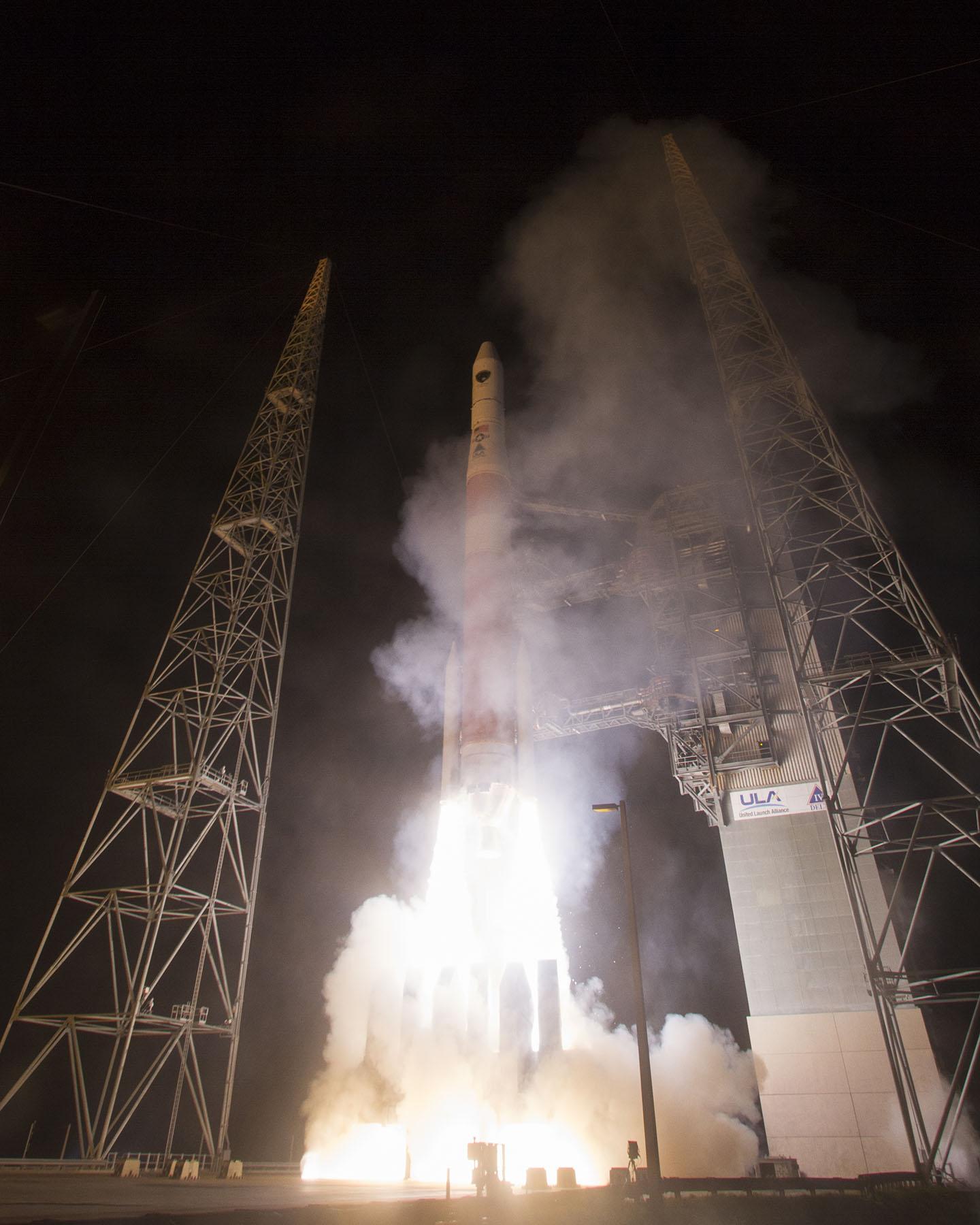
A United Launch Alliance Delta IV lifts off from Space Launch Complex-37 with the Air Force’s Global Positioning System (GPS) IIF-5 satellite. This launch marked the 25th Delta IV flight since the first flight in 2002. Credit: Ben Cooper/ULA
News compiled with the assistance of CANSPACE listserv.
After a brief delay due to concerns over solar radiation trends, the GPS IIF-5 satellite was successfully launched at the end of the designated launch window at 01:59 UTC on February 21. The satellite, attached to the launch rocket’s upper stage, was initially placed in a highly elliptical orbit. Following a third burn of the rocket, the satellite was released into its assigned orbit at about 05:37 UTC today.
Here is a video showing highlights of the launch:
GPS IIF-5 will replace the aging spacecraft known as GPS IIA-28 in Plane A, Slot 3 of the constellation.The GPS IIA-28 satellite was launched aboard Delta 249 on November 5, 1997, as the final member of the Block IIA series. It will go into a reserve role in the network for the remainder of its useful life.
This is the first of three GPS launches planned through July to replace aging craft in the constellation. GPS IIF-5 incrementally upgrades the constellation with improved accuracy, enhanced internal atomic clocks, better anti-jam resistance, a civil signal for commercial aviation, and a longer design life, all features of the Boeing-build Block IIF series. This will be the fifth of 12 Block IIF spacecraft being built to form the backbone of the GPS fleet for the next 15 years.
Launch logo. The nickname of the IIF-5 satellite is Canopus, the brightest star in the modern constellation Carina and the second brightest star in the night-time sky, after Sirius.
According to the Air Force, the new capabilities of the IIF satellites will provide greater navigational accuracy through improvements in atomic clock technology, a more robust signal for commercial aviation and safety-of-life applications, known as the new third civil signal (L5), a second civil signal (L2C) available for the dual-frequency GPS receivers and a 12-year design life providing long-term service. These upgrades improve anti-jam capabilities for the warfighter and improve security for military and civil users around the world.
“I am pleased with the outcome of today’s launch. The new capabilities provided by the IIF satellites will improve operations, sustainment and overall GPS service for the warfighter, international, commercial and civil communities,” said Col. Bill Cooley, director of the Space and Missile Systems Center’s Global Positioning Systems Directorate.
“The modernized capabilities that are coming on board with the successful launch of GPS IIF-5 will support the worldwide GPS community for years to come. I would like to recognize the outstanding commitment and the superb dedication to mission success from the 45th and 50th Space Wings, our industry partners: Boeing and United Launch Alliance, and the GPS IIF and Delta IV program teams at the Space and Missile Systems Center,” said he said.
The GPS Block IIF satellites are built by Boeing, and are operated by the United States Air Force following their launch by United Launch Alliance, using Evolved Expendable Launch Vehicles.
The first GPS IIF satellite was launched on May 27, 2010, and entered service on Aug. 26, 2010.
The second satellite, which launched on July 16, 2011, entered service on Aug. 22, 2011.
The third satellite launched on Oct. 4, 2012, and entered service 22 days later.
The fourth IIF was launched May 15, 2013, and entered service on June 21, 2013.
Every modern GPS satellite was launched from Cape Canaveral Air Force Station.
Each GPS IIF satellite delivers:
Greater navigational accuracy through improvements in atomic clock technology,
A new civilian L5 signal to aid commercial aviation and search and rescue operations,
Improved military signal and variable power for better resistance to jamming in hostile environments,
A 12-year design life providing long-term service and reduced operating costs,
An on-orbit, reprogrammable processor that can receive software uploads for improved system operation.
“Once again, a group of talented mission partners rose to the challenge of launching another successful mission from the Cape,” said Col. Douglas Schiess, commander, 45th Operations Group, who served as the Launch Decision Authority. “Those mission partners include the 45th Space Wing, the Space and Missile Systems Center, the 50th Space Wing, United Launch Alliance, Boeing, and our other industry partners with the Delta IV and GPS IIF launch teams.”
A United Launch Alliance Delta IV lifts off from Space Launch Complex-37 with the Air Force’s Global Positioning System (GPS) IIF-5 satellite. This launch marked the 25th Delta IV flight since the first flight in 2002.A United Launch Alliance Delta IV lifts off from Space Launch Complex-37 with the Air Force’s Global Positioning System (GPS) IIF-5 satellite. This launch marked the 25th Delta IV flight since the first flight in 2002.
The United Launch Alliance Delta 4 rocket family will launch a new GPS IIF satellite from Cape Canaveral Thursday night.
Liftoff is scheduled for Thursday at 8:40 p.m. EST, at the start of a 19-minute launch opportunity, according to the United Launch Alliance. The window is timed to deliver the GPS IIF-5 satellite directly into Plane A of the navigation network 11,000 miles above Earth.
GPS IIF-5 will replace the aging spacecraft known as GPS IIA-28 in Plane A, Slot 3 of the constellation. The GPS IIA-28 satellite was launched aboard Delta 249 on November 5, 1997, as the final member of the Block IIA series. It will go into a reserve role in the network for the remainder of its useful life.
This is the first of three GPS launches planned through July to replace aging craft in the constellation. GPS IIF-5 incrementally upgrades the constellation with improved accuracy, enhanced internal atomic clocks, better anti-jam resistance, a civil signal for commercial aviation, and a longer design life, all features of the Boeing-build Block IIF series. This will be the fifth of 12 Block IIF spacecraft being built to form the backbone of the GPS fleet for the next 15 years.
The Delta’s flight will last three hours and 33 minutes from liftoff until spacecraft separation, firing its cryogenic upper stage in three different burns to reach an initial parking orbit and taking a two-step transfer route to reach the circular GPS orbit tilted 55 degrees to the equator.
Gen. William Shelton, chief of Air Force Space Command, said the date when prime contractor Lockheed Martin and payload manufacturer Exelis are expected to have the first GPS satellite ready for launch will slip from its original target at the end of this fiscal year, according to National Defense Magazine. Technical difficulties are slowing the development process, he said.
“We’re not happy at all. Is my patience wearing thin? Yes. Has it gotten to the place where I am going to step off the cliff? No,” he said at a breakfast sponsored by the Air Force Association’s Mitchell Institute.
Gen. Shelton said the Air Force is working closely with the contractors.
Shelton said the issue highlights the problem inherent in relying on one contractor for a critical technology, reports Space News. Exelis Geospatial Systems has supplied the payloads for all previous generations of GPS satellites.
“The payload hardware is built and is currently in test,” said Jared B. Adams, director of communications for Exelis geospatial systems, in an email to National Defense Magazine. “Last year, Exelis identified some development issues with the navigation payload for the first GPS III satellite that needed further work. Significant testing with flight-like engineering units and the first GPS III satellite’s flight hardware indicates that the known technical issues have been resolved, and GPS III will meet all mission and quality requirements.”
The payload delay is not expected to push back the first launch of the Lockheed Martin-built GPS III satellites in 2015. Lockheed Martin Space Systems is under contract to build eight GPS III satellites.
Exelis has successfully completed several software upgrades for the new Global Positioning System Next Generation Operational Control System, or GPS OCX. Integration and testing were recently conducted on iteration 1.5 of the OCX navigation, encryption and Mission Upload Generator, or MUG, software.
The new version of GPS software will help ground controllers better understand the satellites’ exact positioning in space. The encryption software is also designed to automatically code and decode GPS signals, facilitating the exchange of user information by securely transmitting navigation payload data between the OCX ground system and the orbiting constellation of satellites.
The MUG software is responsible for creating spacecraft payload updates to refresh the navigation data transmitted to all GPS users. This data is typically generated for each satellite multiple times a day and helps to consistently minimize user error.
“These software milestones demonstrate a clear path to improved GPS accuracy and integrity,” said Drew Trainor, OCX program manager for Exelis Geospatial Systems. “Civilian and military users will have more accurate and secure GPS signals, and these milestones bring us one step closer to GPS modernization.”
Under a February 2010 contract award from Raytheon, Exelis is providing software that will simulate the behavior of GPS signals in space. In addition, Exelis is building high-precision receivers for use in ground monitoring stations placed strategically around the world. Exelis is also providing data encryptors that help ensure secure information exchange between the ground and space segments of the system.
Once the new operational control segment is implemented, GPS will improve a variety of business and economic practices, including air traffic control, crop management, and environmental monitoring, among others. The new capabilities offered by GPS modernization will also provide military users increased accuracy, availability, anti-jam power and international interoperability.
Raytheon Intelligence and Information Systems has been awarded a change order for work that costs up to $8.5 million on its existing contract to ensure that the new military signal, M-code, works with the GPS Operational Control System, according to an announcement from the Pentagon as reported by Space News.
Raytheon is building the ground station (OCX) for a new generation of satellites that will bring more safety and precision to GPS. The contract modification is to assure implementation of M-code capabilities across OCX Block 1 and 2. M-code is the new highly secure, anti-jam signal designed for the GPS III constellation. The current GPS ground control system lacks M-code capability.
The OCX is designed to work with the advanced GPS III positioning, navigation and timing satellites, slated to start launching in 2015, and also will be backwardly compatible with existing GPS satellites.
Raytheon won the $886.4 million prime contract to develop the OCX in February 2010. Work will be performed at Raytheon’s facility in Aurora, Colorado, and is expected to be completed by August 31, 2016.
The Air Force Space and Missile Systems Contracting Directorate, Los Angeles Air Force Base, California, is the contracting agency.
Details on the contract change order: Raytheon Intelligence and Information Systems, Aurora, Colo., has been awarded an unpriced change order (P00112) with a not-to-exceed of $8,595,748 on an existing contract (FA8807-10-C-0001) for M-Code Implementation on the Operational Control System. The contract modification is to assure implementation of M-Code Capabilities across OCX Block 1 and 2. Work will be performed at Aurora, Colo., and is expected to be completed by Aug. 31, 2016. Fiscal 2014 research and development funds will be obligated at definitization. The Air Force Space and Missile Systems Contracting Directorate, Los Angeles Air Force Base, Calif., is the contracting activity.