The transaction is expected to close in the third quarter, contingent on normal regulatory approvals.
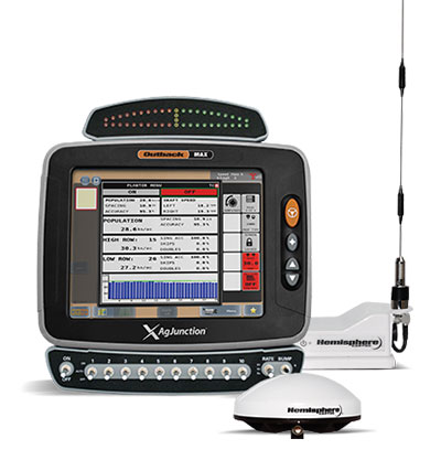
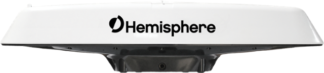
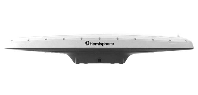
The Outback MAX terminal with ISOBUS. (Photo: Outback Guidance)
The acquisition aligns with Hemisphere’s continued push into the global agriculture market, Hemisphere GNSS said. In addition to the included IP licenses for business into the dealer channel, a second license was signed to allow agriculture steering solutions sales into OEM (original equipment manufacturer), VAR (value-added reseller) and all other segments of the agriculture supply chain.
As a result of these agreements, Hemisphere will assume ownership of the Outback Guidance assets, including channel, infrastructure and trademarks. Additionally, licenses to intellectual property and related technology have been executed.
Also included are two product development, sales, and support facilities, including personnel located in Hiawatha, Kansas, United States, and Winnipeg, Manitoba, Canada.
“The decision to acquire the Outback Guidance business will significantly accelerate Hemisphere’s expansion into the global agriculture market and allow stronger integration between Hemisphere’s core competency GNSS and Outback’s highly refined steering solutions,” said Farlin Halsey, president and chief executive officer of Hemisphere GNSS.
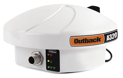
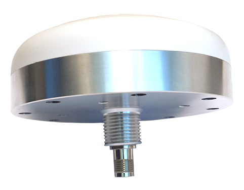
The Outback A320 smart antenna. (Photo: Outback Guidance)
“We are very pleased to be bringing on board additional seasoned personnel with strong agriculture domain experience, a strong product line with deeply embedded agricultural technology and a well-accepted, reputable brand in Outback,” Halsey said. “We will also be bringing back together many years of history and legacy between the two organizations.”
The addition of Outback Guidance represents Hemisphere’s continued effort to make significant investments to expand its presence in the global agricultural market. Hemisphere has seen successful revenues and wide-reaching positive feedback in recent years with its OEM focused agriculture products. Hemisphere seeks to further integrate its high-precision GNSS positioning technology via systems and services offered by the Outback Guidance dealer network, the company said.
The Outback Guidance channels of communication including customer support, sales, and website will remain as they currently operate. The Outback Guidance dealer network will not see any interruption during this transition period.
The UM442 can simultaneously track GPS, BDS, GLONASS and Galileo. It also supports SBAS and QZSS. It uses Uncore’s new-generation Nebulas II chip and UGypsophila real-time kinematic (RTK) algorithm. Based on high-performance data-sharing technology and the simplified operation system of the Nebulas II chip, the UGypsophila RTK algorithm dramatically optimizes matrix processing, enabling the UM442 to track more satellites and shorten the initialization time to 5 seconds.
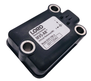
The MV5-AR inertial sensors are designed for off-highway and military vehicles, marine and mobile robot applications, and the autonomous vehicle market. The rugged, compact sensors use LORD’s fifth-generation high-performance industrial-grade solid-state six-degrees-of-freedom (6-DOF) micro-electromechanical accelerometer and gyro inertial sensor technology. Successfully deployed on ground robots and heavy machinery, applications also include autosteer and terrain compensation; dynamic incline detection (roll, pitch, rotation); vehicle stability and leveling; platform control, alignment and stabilization; operator feedback; and precision navigation. The compact and rugged reinforced housing is fully sealed for immersion and pressure wash. Each sensor is calibrated and temperature compensated.
BeiDou Phase 3 signals are now available on Spirent GNSS RF constellation simulators GSS7000 and GSS9000 — existing users can obtain the software upgrade by contacting Spirent. Phase 3 of the Chinese BeiDou system will extend its coverage from Asia to the entire world, providing receiver developers and integrators with additional GNSS signals to make positioning, navigation and timing systems more accurate, and help to support new applications, such as autonomous vehicles. Customers can test their designs before the system is fully operational in 2020.
The ZED-F9P multi-band GNSS module has integrated multi-band real-time kinematic (RTK) technology for machine control, ground robotic vehicles and high-precision unmanned aerial vehicles applications. It measures 22 x 17 x 2.4 millimeters and uses technology from the u‑blox F9 platform to deliver robust high-precision positioning performance in seconds. The ZED-F9P is a mass-market multi-band receiver that concurrently uses GNSS signals from all four GNSS constellations (GPS, GLONASS, Galileo and BeiDou). Combining GNSS signals from multiple frequency bands (L1/L2/L5) and RTK technology lets the ZED‑F9P achieve centimeter-level accuracy in seconds.
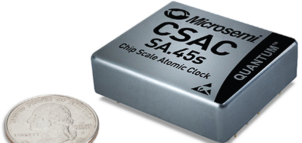
The SA.45s Commercial Space Chip-Scale Atomic Clock (CSAC) is a commercially available radiation-tolerant CSAC suitable for low Earth orbit (LEO) applications. The device provides the accuracy and stability of atomic clock technology while achieving significant breakthroughs in reduced size, weight and power consumption. It provides excellent drift performance and built-in 1 pulse per second (PPS) input for GPS disciplining, making the device well-suited for holdover applications. Commercial and research space applications include satellite timing and frequency control; satellite cross linking; assured position, navigation and timing; and Earth observation.
The long-range, power-efficient eRadio is designed to support high-precision GNSS real-time kinematic (RTK) applications in surveying and precision agriculture. It is enabled with intelligent serial baud rate identification for different RTK devices. It can automatically identify RTK serial baud rate with a radio data cable and provide a plug-and-play form for easy connection between the eRadio and RTK. With its high transmitting power (5-35 Watts), transmission data can be up to 19200 bps/s over a connection distance of 50–80 kilometers. It can work as either a base or repeater with other Harxon radio modems in challenging environments.
Wireless communication with any Android or Windows terminal
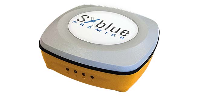
Image: SXblue/Geneq
The SXblue Premier GNSS receiver is available in a submetric version (GNSS) or centimetric version (RTK). It is equipped with Pacific Crest Maxwell 6 Trimble technology with BD910 (GNSS version) and BD930 (RTK version) OEM boards, delivering 220 channels to acquire and track GNSS signals from all constellations in view. It makes effective use of GPS, GLONASS, Galileo, BeiDou, QZSS and SBAS signals for precise positioning.
The single-frequency, multi-GNSS Vector V123 and V133 all-in-one smart antennas are multi-GNSS compass systems using GPS, GLONASS, BeiDou, Galileo and QZSS for simultaneous tracking for heading, position, heave, pitch and roll. Both support NMEA 0183 and NMEA 2000. The V123 and V133 thrive in radar/ARPA, AIS, ECDIS, side-scan survey, multi- and single-beam surveys, dredging and general navigation applications.
The Trak4 provides GPS tracking with cell-trilateration fallback. Ping rates can be selected from every two minutes to once a day, with email and text alerts provided for geozone entry and exit or if the high-capacity rechargable battery is low (the battery runs up to 12 months on a single charge.) The Trak4 is designed for tracking vehicles, assets and inventory; it can also be used to track people such as the elderly. Indoor/outdoor weatherproofing allows “anywhere” mounting.
PCTEL’s multi-GNSS L1/L2/L5 antennas combine aerospace-level precision with global satellite compatibility in a highly durable package. They enable critical applications including vehicular automation, 5G network timing synchronization and Positive Train Control (PTC) systems. The antennas increase the accuracy of timing and location information by providing simultaneous access to multiple GNSS signals across multiple frequency bands. The antennas support all relevant GPS, GLONASS, BeiDou and Galileo frequencies with excellent multipath mitigation and high out-of-band rejection for greater signal clarity. Their robust AAR and IP67-compliant design makes them suitable for years of use on railways and in other harsh real-world environments.
Four new GPS handhelds are designed for off-road use, with safety in mind. All four of the OS GPS models have a built-in SIM card with access to the SeeMe subscription-based service and its safety features. With I.C.E (In Case of Emergency), users can send emergency alerts with exact coordinates to family and friends directly from the OS GPS. Live Tracking enables the user to be locatable at all times, sharing location and performance data with up to 20 friends in real time. Aventura, the most advanced navigation device, can be used in all weather conditions.
Zubie Fleet Connect provides real-time GPS fleet tracking, driver check-in and performance reports, and vehicle health alerts. The monitoring and reporting service lets managers of fleets from 2 to 5,000 vehicles optimize business on the road. Wi-Fi connection to the cloud delivers important information about the health and performance of the vehicle, enhancing driver safety. Zubie also works with large enterprises to develop custom data flows and access driving data that can be used to analyze driving patterns, spot geographical trends in activity, or improve fleet asset management based on vehicle wear and tear.
The Heliscope 2.0 provides onboard data collection with speed, efficiency and productivity improvements for the utility inspection industry. It provides a solution for operations over greater distances or in harsher environments than drones can accommodate The system integrates multiple sensor systems into a single, lightweight helicopter payload, capable of simultaneously collecting a range of data types required for utility maintenance and vegetation management inspections. Deployment enables optimized inspection and maintenance schedules, offering potential cost savings in those operational activities by as much as 50 percent. The Heliscope 2.0 has flexible mounting configurations and the ability to adapt for mounting on many different helicopter types.
Based on DJI’s M600 Pro platform, the Leica Aibot system is designed to rapidly and autonomously enable digitizing of critical infrastructure. It enables users to get a complete data set quickly with a user-friendly interface. Using Leica Infinity for point-cloud, digital surface model and orthophoto generation enables surveyors to process and visualize aerial data. For construction projects, Aibot provides access to critical information to perform volume calculations and monitor site progress. Users can see high-definition imagery and 3D mapping of the site and document progress. The UAV data can be combined with other survey technologies such as GPS for a more complete set of information.
Two lightweight, compact antennas are designed for UAVs with a low aerodynamic profile. Antenna model TW1829 is for original equipment manufacturers (OEMs), and model TW8829 is a housed version. Accutenna technology provides high-level rejection of multipath signals, a phase linear response and tight phase-center variations. Pre-filters prevent saturation of the front-end low noise amplifier by strong near frequency and harmonic signals.
The HA32 high-performance antenna supports GPS, GLONASS, Galileo, BeiDou and Hemisphere’s Atlas L-band correction service. It is designed for UAVs, geographic information systems (GIS), surveying, real-time kinematic (RTK) and other applications requiring high-precision positioning and navigation. The HA32 is built on a proprietary four-helix antenna technology that provides superior filtering and anti-jamming performance with features such as a low noise figure of 2.0 dB (typical) and up to 30-dB gain (typical). Suitable for most outdoor and harsh operating environments, the HA32 antenna is sealed in a durable and ruggedized IP67-rated. The lightweight (40 g, typical), compact form factor (40 x 75 mm) makes it resistant to wind when on UAVs.
As the dust from this year’s AUVSI Xponential show, which took place May 1-4 in Denver, begins to settle, we complete the overview we began last month and wrap up our coverage of the show.
Septentrio
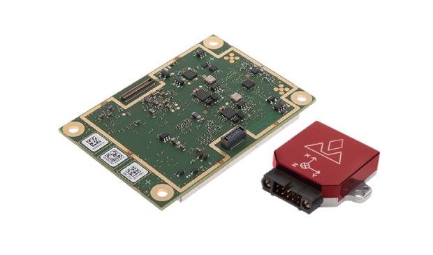
Septentrio introduced its AsteRx-i V product series of integrated GNSS/inertial receivers, based on the Septentrio m2 GPS/GLONASS/Galileo/BeiDou/QZSS/SBAS receiver and a high-end VectorNav MEMS IMU. Providing:
AsteRx-i V receiver & IMU. (Photo: Septentrio)
Reliable, accurate IMU-enhanced GNSS positioning down to the cm level
Full attitude — heading pitch and roll
Lightweight, low power <50 grams, typically 1.5 W — suitable for UAV applications
AIM+ interference monitoring and mitigation system
High update rate, low-latency positioning and attitude
Also introduced at the show was the AsteRx SB, a packaged version of the m2 receiver with multiple interfaces and Bluetooth wireless, targeted at machine control and other sensor fusion applications.
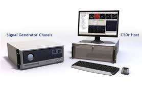
GSS9000 Simulator. (Image: Spirent)
Spirent Federal
Spirent offered a demo of its “flagship” GSS9000 simulator at the show — with capability to generate all constellations, all frequencies, plus L-band signals. Kalani Needham (director of sales) also mentioned the company’s sim-MNSA program with Rockwell Collins, aimed at providing support for M-code for the GNSS simulation market.
DJI
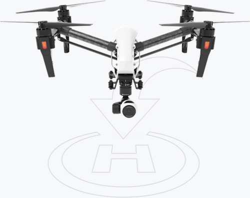
Inspire drone. (Image: DJI)
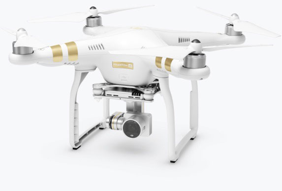
As usual, the DJI booth was extremely busy — with a demo area almost continuously flying each of the most popular DJI drones. What I learnt from my visit was that 70 percent of sales are recreational, and the balance is commercial. With quadcopters for hobbyists, using replaceable parts, auto-flight systems and data links, DJI was virtually the first drone manufacturer to market, and still one of the most successful. The Phantom now carries gimbal-mounted cameras and is finding lots of applications with business, academics and government agencies, including first adopters like the film and TV industry.
Phantom 3 drone. (Image: DJI)
DJI drones have weather resistant bodies, strong blades, swap-out easy-charge batteries, and ADS-B, RTK and heading capabilities. Set-up in the field is simple, with an SDK for lab developers, multi-spectral cameras for applications such as crop growth monitoring, real-time data available through the control uplink and infrared/visible slant-range outputs.
DJI’s approach is to keep ahead of the competition by adding more and more technology over time, and the company clearly has the sales volume to support this strategy.
CyPhy Works
PARC tethered drone system. (Photo: Tony Murfin)
CyPhy Works makes and promotes tethered drones — enabling very long endurance reconnaissance/forward observation/inspection/communications. The company got into this specific drone niche because it found customers who couldn’t live with short duration battery-restricted drone operations.
For ground forces, having a real-time video overview from higher altitude is of great benefit; similarly, they’re of great use for disaster recovery efforts, such as in the aftermath of hurricane Harvey in Texas. And if you add a Wi-Fi transducer working through one of two payload ports on its PARC (persistent aerial reconnaissance and communications) platform, you can also reconnect survivors and provide a comms network for first responders.
Ruggedized Duro receiver. (Image: Swift Navigation)
Swift Navigation
Swift is a relatively new GNSS receiver manufacturer, and its Piksi Multi receiver has a lot to do to catch up technically with the products offered by the predominant players in the market. So its approach is to use rock-bottom pricing for almost all of their offerings. Currently, the Piksi has only GPS L1/L2 and GLONASS L1/L2 plus SBAS, but Galileo and BeiDou are promised for later this year.
The new Swift capability launched at the show is Skylark, a cloud-based, hybrid PPP/RTK network currently testing in around six U.S. areas and planned for national and even worldwide coverage sometime in the future. Skylark is apparently cellular, with a large number of base sites, each equipped with a Swift Duro receiver. With a target subscription price of only $495 per year, this could be a popular GNSS assistance service, provided you use compatible Swift receivers in your application.
Swift is targeting automotive applications, and has a San Jose trial underway with Voyage at a retirement community — residents call for a self-driving taxi using a cell-phone app, and get transport anywhere in the 4,000-strong community. A similar trial at the Villages in Florida (125,000 residents and 750 miles of roads) is also apparently getting underway.
Hemisphere GNSS was also at the show with its line of GNSS receiver solutions for UAVs, Atlas Correction Service and a new V500 Heading/Smart Antenna.
The Vector V500 is an all-in-one multi- frequency, multi-GNSS smart antenna that provides RTK-level position and precise heading. The latest generation of Hemisphere’s heading antennas now appears with an integrated GNSS receiver and a rugged design sealed for the harshest environments — a design that has evolved over many years. It takes a great deal of sweat and tears to get to a reliable weather-hardened product, and Hemisphere has no doubt incorporated a lot of experience into this latest product.
Atlas corrections are derived from public JPL data and are supplied worldwide over Inmarsat L-band satellite transmissions.
Harxon Corporation
D-Helix antenna. (Photo: Harxon)
Harxon’s D-Helix antenna got lots of attention at its booth, as did the OEM frequency-hopping transceiver. The D-Helix antenna supports GPS, Galileo, BeiDou and GLONASS, as well as L-band signal reception. With low wind resistance and ruggedized IP67 protection, this antenna appeared to be very popular at the show for UAV applications.
The frequency-hopping OEM transceiver works over 840-900 MHz and weighs in at only 5 grams. With anti-jamming and wide signal capability, this miniature device is designed for complex data-intensive applications. In full duplex mode, secure data transmissions are possible over long distances with low latency. The popularity for this transceiver at the show might be connected with a recent FAA proposed rule that would require transmission of a drone’s registration ID for remote identification.
More
Other neat products and applications the GPS World team came across at the show included:
Topcon’s B111 multi-constellation GNSS receiver and the Topcon-distributed Sirius Pro fixed-wing UAV and Intel Falcon 8+ quadcopter;
the Rockwell Collins aviation Flight Management System, which is apparently being incorporated into the General Atomics commercial Flight Guardian system;
the senseFly eBee series of drones with automated mapping capability and a BVLOS (beyond visual line of sight) trial in Canada with in-flight data — more on this later.
GPS World will bring you a special UAV supplement later in the year, and we will carry more news and details on selected manufacturers and applications within this exciting and ever-expanding drone industry.
A roundup of recent products in the GNSS and inertial positioning industry from the May 2018 issue of GPS World magazine.
SURVEY & MAPPING
Rugged handhelds
Operate in harsh environments
The UT series of GNSS-capable rugged handheld devices support industries such as construction, survey, GIS, mapping, asset/logistics management, public safety, utilities and military. The UT10 6-inch rugged phone and UT30 8-inch rugged tablet both feature Android 8.0 operating systems with Qualcomm octa-core 2.2 GHz processors, 4 GB of RAM and 32GB onboard storage.The UT50 10.1-inch full-rugged tablet features the Windows 10 operating system with an Intel Core Skylake i5 processor up to 2.8 GHz, 8 GB RAM and 128 GB of onboard storage. All three new UT models provide the latest high-resolution, capacitive touchscreen and direct sunlight-readable display technology for ease of visibility in all situations. The UT50 also has a 10-finger multi-touchscreen and supports wet hands and gloves operation. The devices have dual built-in cameras. They are designed to be drop-resistant from heights of 1.2 meters (1.5 meters for the UT10), are rated at IP67 (IP68 for UT50), and are certified to both MIL-STD-810G and MIL-STD-461F military standards to ensure durability in most outdoor or challenging environments.
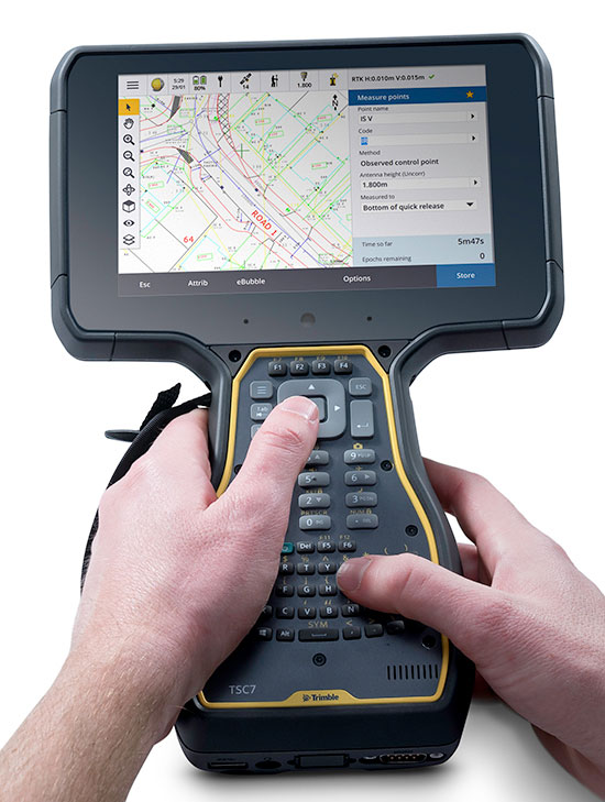
The Trimble TSC7 controller is a new field solution for land and civil construction surveyors. Equipped with GPS, it provides a tablet experience with a physical keyboard and a sunlight-readable 7-inch touchscreen that supports pinch, tap and slide gestures. Front- and rear-facing cameras allow users to video conference their office from the field for on-the-job support, and capture high-definition videos and images that provide valuable context to their data and clients. The TSC7 uses Windows 10 Professional with an Intel Pentium 64-bit quad-core processor. The processor and operating system make it easy to process data in spreadsheets and run office software programs. An ergonomic form factor, IP68-certified rugged design and optional, user-interchangeable modules make the TSC7 a flexible solution for all surveying applications.
The AsteRx-i combines a multi-frequency multi-constellation GNSS engine with an external industrial-grade MEMS-based inertial measurement unit (IMU) to deliver positioning to the centimeter level as well as full 3D attitude at high update rates and low latency. The AsteRx-i is suitable for optical inspection and photogrammetry. Accompanied by a UAS-tailored carrier board, it integrates seamlessly into light UAVs. It also features Septentrio’s AIM+ interference monitoring and mitigation system.
UAS startup DropCopter has initiated a drone pollination service that uses multi-rotor drones to dust almonds, pistachios and cherries, boosting crops by up to 15 percent. Dropcopter’s patent-pending Worker-Bee pollinator helps growers overcome environmental factors like bee shortages, as well as wind, cold, and night time that would prevent honeybee activity. The company is partnered with GENIUS NY and The NUAIR Alliance.
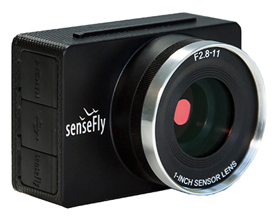
Sensor Optimized for Drone Applications (S.O.D.A.)
Photo: senseFly
The senseFly S.O.D.A. camera is built for professional drone photogrammetry work. It captures sharp aerial images across a range of light conditions, allowing users to produce detailed, vivid orthomosaics and ultra-accurate 3D digital surface models. It has a 1-inch 20 megapixel RGB sensor that provides ground resolution of 2.9 centimeters per pixel flying at 400 feet (122 meters) above ground level. It has built-in dust and shock protection, enabling mapping across challenging terrain.
Hemisphere GNSS made the announcement at AUVSI Xponential, being held this week in Denver, Colorado.
The HA32 is a high-performance antenna that supports GPS, GLONASS, Galileo, BeiDou, Hemisphere’s own Atlas L-band correction service. It was designed specifically for UAVs, GIS, surveying, real-time kinematic (RTK) and other applications requiring high-precision positioning and navigation.
According to the company, the HA32 is built on an innovative and proprietary four-helix antenna technology that provides superior filtering and anti-jamming performance with low noise amplifier (LNA) features such as a low noise figure of 2.0 dB (typical) and up to 30 dB gain (typical).
Suitable for most outdoor and harsh operating environments, the HA32 antenna is sealed in a durable and ruggedized IP67-rated enclosure for protection against dust and water and is equipped with an O-ring. The lightweight (40 g, typical) and compact form-factor (40 mm x 75 mm) design of the antenna makes it resistant to wind when installed on UAVs and offers easy integration with a single subminiature version A (SMA) RF connector.
“We are very excited to be introducing this extremely competitive entry-level UAV GNSS antenna for a wide range of positioning and navigation applications such as UAVs, GIS, and RTK,” said Miles Ware, director of marketing with Hemisphere GNSS. “The features and specifications of this antenna is another example of the innovation and incredible value that Hemisphere is known for.”
AUVSI Xponential attendees can visit the Hemisphere booth (#4228) to see the HA32 UAV GNSS antenna in person.
Hemisphere GNSS has launched a new UT series of GNSS-capable rugged handheld devices to support industries such as construction, survey, GIS, mapping, asset/logistics management, public safety, utilities and military.
The UT handheld devices are designed to work in the harshest environments imaginable and offer impressive and powerful feature sets.
Hemisphere made the announcement at Intermat Paris 2018, where it is exhibiting at stand 6 J 027.
The UT10 6-inch rugged phone and UT30 8-inch rugged tablet both feature Android 8.0 operating systems with Qualcomm octa-core 2.2 GHz processors, 4 GB of RAM, and 32 GB onboard storage.
The UT50 10.1-inch full-rugged tablet features the Windows 10 operating system with an Intel Core Skylake i5 processor up to 2.8 GHz, 8 GB RAM, and 128 GB of onboard storage.
According to the company, all three new UT models provide the latest high-resolution, capacitive touchscreen and direct sunlight-readable display technology for ease of visibility in all situations. The UT50 also has a 10-finger multi-touchscreen and supports wet hands and gloves operation.
The devices have dual built-in cameras. The UT10 and UT30 handhelds feature 13 MP rear and 5 MP front cameras.
The devices are designed to be drop-resistant from heights of 1.2 meters (1.5 meters for the UT10), are rated at IP67 (IP68 for UT50), and are certified to both MIL-STD-810G and MIL-STD-461F military standards to ensure durability in most outdoor or challenging environments.
The UT10 and UT30 are powered by single 8,000m Ah and 8,200 mAh batteries with Qualcomm Quick Charge 3.0 technology, while the UT50 offers dual hot-swappable batteries at 2,900 mAh each so users can continue working in the field without powering down.
“With varying specifications and options between these devices, mobile workers are sure to find them suitable to fit their demanding work environments,” said Miles Ware, director of marketing with Hemisphere GNSS. “These powerful machines reflect the latest in hardware standards and are exceptional complimentary additions to our product portfolio.”
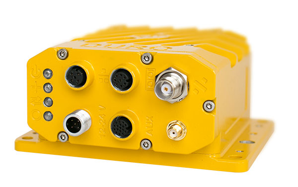
Hemisphere GNSS has made significant achievements with its GradeMetrix OEM toolkit for high-precision GNSS-based machine control and guidance applications and systems.
Hemisphere has expanded its portfolio of hardware offerings, including the A222 Scalable GNSS Smart Antenna introduced in November 2017, and made significant strides forward with its next-generation GradeMetrix OEM application software platform.
Whether it is grading, mining, excavating, drilling and piling, or compaction applications, heavy equipment manufacturers can rebrand the solution and drive feature requirements to sell as their own.
Hemisphere made the announcement at Intermat Paris 2018, where the company is exhibiting at stand 6 J 027.
The GradeMetrix toolkit allows OEMs to select components, a-la-carte or as complete solutions, based on their accuracy and durability requirements and integrate into their machines to design their own IP. This allows manufacturers to maintain a competitive advantage in the marketplace, as they do not have to compete with conventional or traditional machine control and guidance dealers selling aftermarket systems, the company said.
Hemisphere owns the design of the toolkit and its components and ensures each component is reliable with guaranteed compliance through design. The fully customizable and flexible toolkit provides the ability to tailor displays and outputs, per OEM requirements, and also offers OPA (open architecture) for implementing inputs and third-party sensors already available on machines.
Through UniStrong, Hemisphere’s parent company, the GradeMetrix toolkit also has seamless access to complimentary and innovative technologies. This allows for much faster times to market, driving increased revenue streams for OEMs, and provides a high cost/value ratio.
“The feedback we are receiving from OEMs already using our GradeMetrix toolkit is outstanding,” said Randy Noland, vice president of Global Sales & Business Development with Hemisphere GNSS. “For the first time in our industry, we are offering OEMs the opportunity to build their own machine control and guidance systems using their specifications and offering it to their customers, with their brand, 100% of the time.”
Manufacturers are looking for flexibility and price performance in existing system offerings or in new systems. Hemisphere continues to provide anfull system OEM positioning solution toolkit for building powerful, complete or a-la-carte machine control and guidance systems including GradeMetrix OEM application software and an array of compatible GNSS hardware components.
These include IronOne Rugged Display & Computer, A222 Scalable GNSS Smart Antenna, A326 Rugged GNSS Smart Antenna, Vector VR500 Rugged All-In-One Smart Antenna, Vector VR1000 Rugged GNSS Receiver, and C321+ RTK Base & Rover with SiteMetrix Site Management Software.
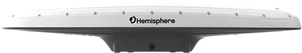
Hemisphere GNSS has released the new single-frequency, multi-GNSS Vector V123 and V133 all-in-one smart antennas with integrated Atlas L-band designed for professional and commercial marine applications.
The company made the announcement at the Oceanology International conference being held this week in London, U.K.
Powered by Hemisphere’s Crescent Vector technology, the new V123 and V133 are multi-GNSS compass systems using GPS, GLONASS, BeiDou, Galileo and QZSS for simultaneous satellite tracking to offer heading, position, heave, pitch and roll. Both antennas support NMEA 0183 and NMEA 2000.
The V123 and V133 thrive in radar/ARPA, AIS, ECDIS, side-scan survey, multi- and single-beam surveys, dredging and general navigation applications.
The V123 and V133 rugged smart antennas combine Hemisphere’s recently announced Crescent Vector H220 OEM board and two superior multipath- and noise-rejecting antennas (spaced 50 centimeters apart) in a single enclosure.
The smart antennas require only a single power/data cable connection for fast and reliable installations, even in the presence of strong radio transmissions. Both Vector models provide 0.3-degree heading accuracy and sub-meter DGPS accuracy, as well as optional 0.5-meter Atlas L-band accuracy.
The V133 includes all the features of the V123 and adds the capability of receiving differentially corrected data from land-based beacon stations. Ease of installation and no maintenance or servicing enhances the simplicity of these new Vector models.
“The Vector V123 and V133 GNSS compasses represent significant enhancements to our industry leading models they replace, providing even greater performance, improved robustness and excellent value,” said Miles Ware, director of marketing at Hemisphere GNSS. “Users now have an even higher performing all-in-one Vector for their commercial and professional needs with the addition of BeiDou, Galileo, and QZSS as well as Atlas L-band corrections.”
Hemisphere GNSS has introduced the Vector V1000 GNSS receiver for precision marine applications. The V1000 provides high-accuracy heading, position, pitch, roll and heave data.
The company made the announcement at the Oceanology International conference being held this week in London, U.K.
The V1000 supports multi-frequency GPS, GLONASS, BeiDou, Galileo, QZSS and IRNSS (with future firmware upgrade and activation) for simultaneous satellite tracking. The receiver is powered by Hemisphere’s Athena real-time kinematic (RTK) engine and is Atlas L-band capable.
The new V1000 is designed for professional marine applications, such as hydrographic and bathymetric surveys, dredging, oil platform positioning, buoys and other applications that demand the highest level 3D positioning accuracies. Based on Hemisphere’s Eclipse Vector technology, the V1000 uses the most accurate differential corrections including RTK and Atlas L-band.
The V1000 is Hemisphere’s flagship receiver, with an integrated display, that can be conveniently installed near the operator. The two antennas can be installed at user-specified separation, providing valuable flexibility in terms of install locations and desired heading accuracy.
The V1000 has heading accuracy of better than 0.01 degree when using a 10-meter antenna separation. With CAN, serial, Bluetooth, Wi-Fi and Ethernet support and flexible installation, the all-new rugged enclosure gives the V1000 the advantage of working reliably in harsh environments, the company said.
Hemisphere GNSS has released its RTK-enabled Vector V500 smart antenna. The company made the announcement at the Oceanology International conference being held this week in London, U.K.
The V500 supports multi-frequency GPS, GLONASS, BeiDou, Galileo, QZSS and IRNSS (with future firmware upgrade and activation) for simultaneous satellite tracking. The V500 is powered by Hemisphere’s Athena RTK (real-time kinematic) engine and is Atlas L-band capable.
Using Hemisphere’s Eclipse Vector technology, the all-in-one V500 is a complete compass system that offers GNSS-based heading, pitch, roll, heave and RTK positioning, the company said.
The V500 introduces support for Ethernet, Bluetooth and Wi-Fi in addition to NMEA 0183 and NMEA 2000 and offers unmatched ease of installation.
Purpose-built for challenging applications, the V500’s rugged enclosure works reliably in harsh environments and is designed for professional marine applications requiring high-precision heading combined with RTK or Atlas positioning.
The V500 is Hemisphere’s flagship rugged smart antenna. It combines the recently announced Eclipse Vector H328 OEM board with two superior multipath- and noise-rejecting antennas (spaced 50 cm apart) in a single enclosure.
The V500 requires a single power/data cable connection, allowing for fast and reliable installations even in the presence of strong radio transmissions.
According to Hemisphere GNSS, the V500 delivers 0.17 degree heading accuracy along with RTK positioning and Atlas L-band accuracies of up to 8 cm (95 percent).
“The Vector V500 combines our expertise in GNSS, smart antenna design, and our new technology features such as Atlas,” said Lyle Geck, senior product manager at Hemisphere GNSS. “With very competitive RTK performance and the simplicity of installation offered by the all-in-one smart antenna design, it is an incredible product.”
Atlas GNSS Global Correction Service. Atlas is a flexible and scalable GNSS-based global L-band correction service providing robust performance and correction data for GPS, GLONASS and BeiDou, the company said. Atlas delivers correction signals via L-band satellites to provide accuracies ranging from sub-meter to sub-decimeter levels, and leverages approximately 200 reference stations worldwide, providing coverage to virtually the entire globe.
Atlas is available on all Hemisphere Atlas-capable single- and multi-frequency, multi-GNSS hardware and complements third-party GNSS receivers by using Atlas corrections with Hemisphere’s SmartLink and BaseLink capabilities. Atlas creates fast convergence times, and is robust and reliable near wharfs, piers, offshore rigs, cranes and other overhead obstructions.
Atlas Basic provides users of both single- and multi-frequency Atlas-capable hardware the ability to achieve better than SBAS performance anywhere Atlas correction service is available. Atlas Basic offers accuracy of 30 cm (pass-to-pass 95%) to 50 cm (absolute 95%) and offers instantaneous sub-meter accuracy.
The Vector V500 is featured in the Hemisphere GNSS booth (G500) at the Oceanology International exhibition and conference in London, UK, March 13-15. The new V500 will be available soon through Hemisphere’s global dealer network.
Hemisphere GNSS has debuted the scalable A222 GNSS Smart Antenna. Purpose-built for harsh outdoor applications, the A222 is designed for both agriculture and basic indicate systems markets, as well as other markets requiring flexible positioning.
The smart antenna has the flexibility to scale and grow as business expands and can be configured from L1-only to multi-GNSS, multi-frequency and real-time kinematic (RTK) capable. The A222 adds a system component so that tractor and farm equipment manufacturers can deliver their own guidance and control solutions to their customers.
Designed to excel in challenging environments, the A222 uses Hemisphere’s Athena RTK engine and is Atlas L-band capable. It is easy to mount and customizable. Its dual-serial, CAN and pulse output options are compatible with almost any industry-standard interface.
As the A222 is Atlas-capable, it has the ability to use the new Atlas AutoSeed technology. Atlas AutoSeed allows users to suspend Atlas use for any period, and upon returning to their last location, AutoSeed rapidly re-converges to a high-accuracy converged position.
A222 comes pre-configured with Atlas Basic activated.
Hemisphere GNSS debuted the A222 at Agritechnica 2017, held Nov. 12-18 in Hannover, Germany. Hemisphere is exhibiting at Hall 15, Booth E10.
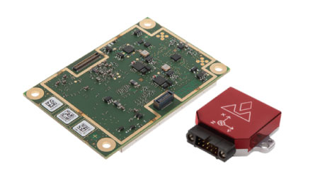
Hemisphere GNSS’ Miles Ware gives GPS World an overview of the new products the company brought to Intergeo 2017, including its H220 OEM board, H328 GNSS compass board, P328 OEM board and S321+ survey smart antenna.