Tag: Hemisphere GNSS

  • Case study: Firms collaborate on product development

    Professional GNSS users now expect lightweight, easy-to-use receivers optimized for their particular workflows. Meanwhile, a streamlined manufacturing process means design and production of sophisticated instruments now takes months rather than years, and relies on global teams of networked specialists.

    Carlson Software approached Hemisphere GNSS in early 2015 with the goal of bringing a new GNSS receiver to market, one optimized for land surveyors with high precision, convenience, and small form factor. “We work closely with land surveyors, and we definitely saw a need,” said Carlson’s director of special projects Karl Nicholas. “Our clients were asking for smaller, lighter receivers. We also felt that a new receiver could be better optimized to work with the multiple satellite constellations now available, and with the array of RTK solutions that surveyors use routinely.”

    Hemisphere recognized that a new lightweight receiver would also serve its own marine clients well, especially if it was optimized to work with the company’s Atlas GNSS Global Correction Service as both rover and base station.

    The S321 smart antenna by Hemisphere GNSS.
    The S321 by Hemisphere GNSS. Photo: Hemisphere

    Carlson focuses on computer-assisted design (CAD) software, field data collection, and machine control products for land surveying, civil engineering, construction, and mining. Through the partnership, Hemisphere gained access to a deep knowledge base of how surveyors work with GNSS in real-world conditions, and how to optimize a new receiver for fieldwork of all kinds.

    This aided decisions about interface, form factor, and features. Project dialog between the two companies identified specifications for particular functions and features, as prototypes became available for testing and feedback.

    Specifications included:

    Compact and Durable. A form factor for a smaller receiver had already been developed. “Our hardware design and manufacturing division in China presented a hardware design that we really liked, so we didn’t have to redesign from scratch in that area,” explained Hemisphere senior product manager Lyle Geck. “We were able to move ahead with only minor modifications.”

    Carlson tested rigorously before signing off on the hardware design. “I put mine on top of a two-meter pole and dropped it onto concrete and dirt, and I also tried it out in wet weather — worked fine!” recalled Nicholas.

    Multiple Constellations. “We now have a receiver that works seamlessly right now with GPS, GLONASS, and the Chinese BeiDou system,” added Nicholas. “And when Europe’s Galileo system becomes available, we’ll be ready for it too.”

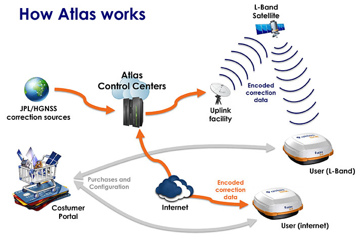
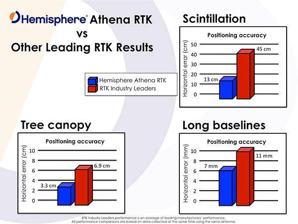
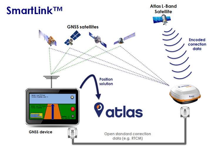
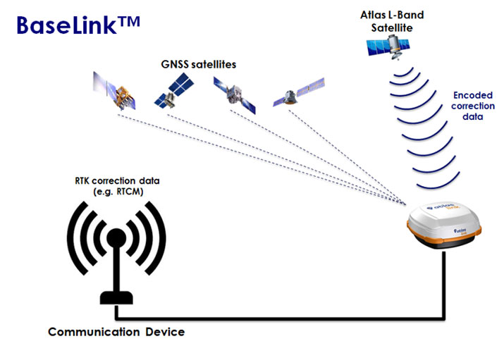
    RTK, Correction Sources. Hemisphere’s Athena RTK engine, is designed to process the new signals with high-accuracy performance. In addition to traditional RTK correction methods using NTRIP and UHF/900 MHz radios, Hemisphere also provides Atlas, its own L-band correction service: subscription-based, flexible, available over the Earth’s landmass, from approximately 200 reference stations, providing up to sub-decimeter accuracies via L-band satellites or over the Internet.

    The new receiver was also designed with a built-in UHF radio, and multiple wireless communication ports to enable corrections via radio, cellular modem, Wi-Fi, Bluetooth, or serial connections.

    Base Station Capacity.
    The receiver can serve as both rover and base station. “For our marine clients, this receiver is actually more likely to be used as a base station,” said Geck, typically set up in a port for construction or other maritime operations. Not a closed system, it works with Atlas, other protocols like TrimTalk, and with external radios that can be connected as needed.

    Productivity.
    For surveyors, Carlson specified a compass and a tilt sensor so the receiver knows if the pole is vertical, how it’s oriented horizontally, and how to correct for those factors. It works for stakeouts and recovering points; the unit directs the user to the next point graphically, saving time.

    For surveyors in obstructed areas, position reliability will often degrade. “Surveyors are aware of this, but it’s hard to compensate when they don’t have information about just what’s happening with accuracy.” SureFix uses proprietary algorithms and various inputs to give a quality indicator for particular points, for confidence when shooting in difficult multipath conditions, or telling a surveyor to slow down to get the required precision. This improves fieldwork and can eliminate trips back to the field to correct errors.

    Carlson Software leveraged its 30+ years in land surveying, while Hemisphere GNSS added manufacturing experience and GNSS and RTK expertise. The result is a compact receiver, BRx6 from the former and S321 from the latter, tuned for the requirements and workflows of customers’ daily projects.

  • Hemisphere GNSS discusses UniStrong, new OEM module at Intergeo 2016

    Hemisphere GNSS announced the Eclipse P328 OEM module at Intergeo 2016, which was held Sept. 11-13 in Hamburg, Germany. The Eclipse P328 is the next offering in a line of new and refreshed, low-power, high-precision, positioning OEM boards.

  • Sensor integration key at InterGeo

    Last year at InterGeo 2015, UAVs ruled, for at least the second year in a row, although some of its newest-thing gloss seemed to be wearing off. This year, sensor integration in both hardware and software is a dominant theme — and one with broader implications and applications.

    GNSS positioning technology, aided in many cases by laser scanning, other imaging sensors, total stations, Lidar and camera systems, all collaborating as inputs to mobile mapping systems or machine-control systems, together form a durable platform for many present and future applications.

    NavCom booth at InterGeo.
    NavCom booth at InterGeo.

    Among the GPS/GNSS companies exhibiting here: CHC Navigation, ComNav Technology, Eos Positioning Systems, Hemisphere GNSS, Navcom Technology, NovAtel, Septentrio, and Tallysman.

    “I think it’s a must for every surveyor to participate and get updated with all the developments,” said Chryssy Potsiou, president of the International Federation of Surveyors (FIG), “to try to make the best combination of tools and software so that we can have the best output, in order to provide reliable services at affordable prices, in short time.  The world needs solutions, cheap and fast.”

    Smart Cities. Along with the roar of the four connected exhibition halls where many new products are being rolled out on this premier world stage, there is a lot of talk — a lot of talk — in the presentation auditoriums about vision, and smart cities, and connectedness in it many forms, electronic and otherwise.

    The international trade fair for geodesy, geoinformation and land management, InterGeo can be overwhelming, with roughly 550 exhibits from 33 countries, and 16,000 visitors from 92 countries. It spans everything from surveying, geoinformation, remote sensing and photogrammetry to complementary solutions and technologies, processing, using and analyzing geodata over the Internet and exploring new applications and solutions — it’s all here. Themes include mobility, energy supply, climate protection, and liveable cities and rural areas. Citizen involvement, data protection, data security and e-government all play a key role in future developments. This year, the conference published a pre-show report on geodata and what it calls Business World 4.0.

    Host city Hamburg, an economically strong, vibrant city and one of the top three shipping ports in Europe, embraced digital strategy at an early stage. Sustainable city planning, climate protection, an intelligent mobility concept and IT-controlled port management are all aspects of the city that could not work without geodata.

    Making Connections. “Our [geospatial] industry is now more and more related, more and more embedded with many other disciplines,” said Nigel Clifford, CEO of Ordnance Survey UK, who gave one of the conference keynotes. “One of the key questions we are facing is: What skills will the workforce of the future need to have, in order to flourish in this interconnected world?

    “Some of the more obvious ones are digital capability, looking at data sciences. Also we spoke about some of the softer skills: the ability to look across disciplines, the ability to work with different functions, and really importantly, the ability for our industry to explain its value and be part of the decision-making which is going on around us all the time.

    “We’re beginning to see the first fruits of the Internet of Things. There may be some inflated expectations at this point. It’s our job to test that.  I’m confident there are some brilliant use cases developing over the next five years in the fields of health, transport, and community engagement. Making a city more efficient, more livable, more secure, and more business-friendly, to draw tax dollars into the equation. What we’re able to do today is so much more data-rich, so much more connected, than we’ve ever been able to do before. ”

    He cited pilot public-private partnership projects in Manchester and another unnamed UK city going forward in this regard, with involvement from Cisco, Siemens, and British Telecomm along with Ordnance Survey. “It’s a mixed economy coming together, because there isn’t one answer.”

    Looking into the future, he said “Developing nations in particular require a fundamental geospatial fabric in order to boost themselves. I hope there will be a broadening of the focus from what we can do absolutely at the cutting edge of technology with reasonably affluent societies, to thinking about how we can take that into the less affluent societies, and raise all boats through the efforts of this great industry.”

    Gorillas Enter Room. Intel has taken a stake in the commercial drone space with its new Falcon UAV. “Predominantly, we are looking at inspections, construction, agriculture, as well as 3D modeling.” The company was joined by Oracle and Autodesk as first-time exhibitors at the show, and they did not enter timidly; big stands.

    UAV über Deutschland. In moves shadowing those in the United States, the German Minister for Transport spoke about introducing regulations to govern civil and commercial use of UAVs. The newly published draft foresees the introduction of mandatory registration for unmanned aerial systems. Pilots will need a valid license to fly drones above 100 meters.

  • Launchpad: Improved OEM boards from Hemisphere GNSS

    Launchpad: Improved OEM boards from Hemisphere GNSS

    Latest additions to the Eclipse line

    The Hemisphere GNSS P326 OEM board.
    The Hemisphere GNSS P326 OEM board.

    The P326 and P327 support 394 channels and are scalable, offering centimeter-level accuracy in single-frequency or full performance multi-frequency, multi-GNSS, Atlas-capable mode. The platform enables simultaneous tracking of all satellite signals including GPS, GLONASS, BeiDou, Galileo and QZSS, making it a robust and reliable solution.

    The updated power-management system efficiently governs the processor, memory and ASIC — important for multiple integration applications such as handheld and battery-powered devices. The small form factor (41 x 71 millimeters) 34-pin P326 module is a drop-in upgrade for many Hemisphere products. The P327 module (41 x 72 millimeters) is a drop-in upgrade for standard 20-pin modules from other manufacturers.

    Eclipse P326 and P327 Features

    • Athena GNSS engine offers world-class performance
    • Atlas L-band corrections provide position accuracy down to 2 centimeters RMS, positioning sustainability with Tracer technology, and convergence time as low as 10 minutes 
    • Exclusive access to Hemisphere’s Advanced Technology Features: aRTK works when RTK corrections fail and SureFix verifies the fix with virtually 100 percent reliability
    • Flexible scalability to customize needs: DGPS, SBAS, Atlas H10 – H100, sub-centimeter level RTK
    • Full tracking: uses GPS, GLONASS, BeiDou, Galileo, and QZSS

    Hemisphere GNSS, HGNSS.com

  • Carlson releases BRx6 GNSS receiver for surveyors

    Carlson releases BRx6 GNSS receiver for surveyors

    Carlson Software has released the Carlson BRx6, a multi-GNSS, multi-frequency receiver. Each BRx6 contains a multi-constellation, multi-band 372-channel GNSS receiver, Athena RTK technology and an integrated Atlas L-band receiver.

    PositionIT-Carlson-620x620-e1464842339861In addition, the BRx6 contains electronic sensors that measure tilt, direction (electronic compass) and acceleration, supporting Carlson SurvCE’s advanced features such as LDL (live digital level or e-bubble), leveling tolerance, auto by level, tilted-pole correction and advanced stakeout features.

    SurvCE contains sophisticated checks for compass and acceleration anomalies to ensure accuracy.
    Designed for use by surveyors, contractors, builders and engineers, the Carlson BRx6 delivers the high positional accuracy at an affordable price.

    Manufactured to Carlson’s exacting specifications by Hemisphere GNSS, the BRx6 provides robust performance and high precision in a compact and rugged package, Carlson said. With multiple wireless communication ports and an open GNSS interface, the BRx6 can be used as a precise base station or as a lightweight and easy-to-use rover.

    The BRx6 receiver is powered by an Athena RTK (real-time kinematic) engine. RTK corrections can be received over UHF radio, cell modem, Wi-Fi, Bluetooth or serial connection.

    The BRx6 also works as a base and rover with the new Carlson Listen-Listen cloud-based low latency RTK correction delivery service. The Carlson Listen-Listen service taps the built-in cell modem and reduces the need for UHF radio communication.

    Multiple RTK rovers of any type can “talk to” a single BRx6 base by cell modem or Wi-Fi hot spot over extreme long distances. It reduces or eliminates dependency on VRS systems. Listen-Listen is provided on a free, 30-day trial basis with each BRx6 base and rover package purchased.

    The BRx6 receiver can also be used with the subscription-based Atlas service, Hemisphere’s industry leading global correction service provided over L-band communication satellites and the internet.

    When this service is included in an upcoming release of Carlson SurvCE, BRx6 users can achieve sub-decimeter positioning performance anywhere on earth, without the need for a fixed base station, a virtual reference network or other communication infrastructure.

    The BRx6 can be purchased as either a rover or as a base/rover package. The base/Rover package includes two BRx6 GNSS receivers, two hard-sided carrying cases, four BRx6 batteries with two chargers, one GPS tribrach and one tribrach adapter, and two Carlson GPS receiver poles. The Rover package includes the BRx6 GNSS receiver, carrying case, two BRx6 batteries with charger, and cables. The BRx6 rover is available as a network rover (GSM cell modem only) or as a complete rover with UHF radio and GSM cell modem.

    The Carlson BRx6 GNSS receiver is designed to work seamlessly with most data collectors including Carlson’s rugged and popular data collectors: the Carlson MINI2, the Carlson Surveyor2 and the Carlson RT3ruggedized tablet.

  • Hemisphere GNSS reveals new, improved Eclipse OEM boards

    Hemisphere GNSS reveals new, improved Eclipse OEM boards

    Hemisphere GNSS has announced the Eclipse P326 and P327, first in a line of new and refreshed low-power, high-precision, position and heading OEM boards. The boards are the latest addition to the company’s Eclipse series of products.

    The multi-frequency, multi-GNSS Eclipse P326 and P327 are based on an innovative platform that integrates L-band and receives Atlas GNSS corrections on a single small board, the company said. Designed with this new platform, the overall cost, size, weight and power consumption of the P326 and P327 are significantly reduced.

    The Hemisphere GNSS P326 board.
    The Hemisphere GNSS P326 board, a drop-in upgrade for many Hemisphere products.

    The P326 and P327 support 394 channels and are scalable board solutions that offer centimeter-level accuracy in either single-frequency or full performance multi-frequency, multi-GNSS, Atlas-capable mode.

    The small form factor (41 x 71 millimeters) 34-pin P326 module is a drop-in upgrade for many Hemisphere products. The P327 module (41 x 72 millimeters) is a drop-in upgrade for standard 20-pin modules from other manufacturers.

    “Our continuous commitment to innovation in GNSS solutions allows our OEM partners to take their products to the next level,” said Jennifer Keenan, product marketing manager at Hemisphere GNSS. “With integrated L-band for Atlas support, future output rates of 50 Hz, and tracking of 394 channels in such a small form factor, our OEM boards have never been this appealing to system integrators.”

    The latest technology platform enables simultaneous tracking of all satellite signals including GPS, GLONASS, BeiDou, Galileo and QZSS, which the company said makes it a robust and reliable solution, while the updated power-management system efficiently governs the processor, memory and ASIC — important for multiple integration applications such as handheld and battery-powered devices.

  • Hemisphere GNSS enters partnership with CPAC Systems AB

    Hemisphere GNSS enters partnership with CPAC Systems AB

    CPAC-Volvo-W

    Hemisphere GNSS is significantly expanding its strategic partnership with CPAC Systems, Gothenburg, Sweden, owned by the Volvo Group. After signing a large contract, Hemisphere will now be the sole source of GNSS positioning and heading systems to CPAC Systems.

    Hemisphere’s technology is being used in the recently announced Co-Pilot series for Volvo Construction Equipment (Volvo CE) as part of Volvo CE’s industry-changing machine control solutions.

    “We were extremely pleased to be chosen by CPAC for use of our GNSS technology,” said Chuck Joseph, Hemisphere GNSS President and CEO. “We are proud of the relationship we have developed with CPAC over the years. It is one of the most innovative companies in the industry and this latest, deeply integrated solution proves how well we collaborate to create value together. It is the very nature of this agreement that defines Hemisphere GNSS as a company, willing to work with and for our strategic partners. We see it as our responsibility to make certain we align ourselves and our business strategy with our OEM and integrator partners like CPAC.”

    Initially offering its GNSS positioning and heading technology to CPAC to be used in marine applications, Hemisphere’s diverse cross-platform technology portfolio allows it to be applied in other areas where high-precision, high-accuracy GNSS is required.

    “Over the years, Hemisphere GNSS has provided our company with top tier innovation, technology, and service,” said Richard Berkling, President of CPAC Systems. “Hemisphere GNSS’ long term strategy and awareness of their value-added contribution to our customer’s solutions are in perfect alignment with ours which is why we chose them as a partner for the GNSS technology. We look forward to executing this next major phase of our partnership with them.”

  • Hemisphere GNSS debuts smart antenna for survey

    Hemisphere GNSS debuts smart antenna for survey

    Hemisphere GNSS has released the S321, its next-generation multi-frequency, multi-GNSS survey smart antenna. The S321 — designed for land or marine survey — combines Hemisphere’s Athena and Atlas technologies with a new web user interface offering customer-friendly performance.

    For professional marine applications — such as  marine construction, hydrographic surveying or dredging — using the S321 with Athena RTK (real-time kinematic) enables users to achieve impeccable results and maintain peak up-time, the company said. The ruggedized antenna was designed for demanding and challenging environments and meets IP67 requirements.

    The S321 smart antenna by Hemisphere GNSS.
    The S321 smart antenna by Hemisphere GNSS.

    “The S321 is another example of how much Hemisphere has changed,” said Chuck Joseph, president and CEO. “A fantastic survey smart antenna with industry-leading RTK, connectivity, and management capabilities, the S321 offers unbeatable performance and value to the industry.”

    Athena RTK

    Athena excels in environments where high-accuracy GNSS receivers can be used. Hemisphere’s customers have tested and proven Athena’s performance in long baseline, in open-sky environments, under heavy canopy, and in locations experiencing significant scintillation.

    • Initialization time – Reliably consistent initialization performance, while at the same time performing initializations in less than 15 seconds at better than 99.9 percent reliability.
    • Robustness in difficult operating environments – Extremely high productivity under aggressive geographic and landscape-oriented environments for GNSS.
    • Performance on long baselines – Position stability for long baseline applications.
    • Performance under scintillation – Sustained accuracy under ionospheric scintillation activities.

    Atlas GNSS Global Corrections

    The S321 ships preconfigured to test drive corrections from Hemisphere’s Atlas global corrections service. The bundled solution provides users worldwide with an easy way to use Atlas, including the worldwide H10 service offering 8-centimeter, 95-percent accuracy (4 cm RMS).

    Network RTK Augmentation

    BaseLink technology allows Atlas-capable receivers like the S321 to self-calibrate, self-survey, and automatically manage the transmission of RTK correction data to augment or extend established or new GNSS reference networks in areas of poor Internet connectivity.

    The S321 introduces Hemisphere’s aRTK technology. Powered by Atlas, aRTK enables the S321 to operate with RTK accuracies when RTK corrections fail. If the S321 is Atlas-subscribed, it will continue to operate at the subscribed service level until RTK is restored.

    The S321 also introduces SureFix, Hemisphere’s new processor running in combination with Athena to provide high-fidelity RTK quality information that results in guaranteed precision with virtually 100 percent reliability.

    Features:

    • Athena RTK engine
    • GPS, GLONASS, BeiDou, Galileo, QZSS
    • 372 channels
    • Atlas corrections delivered via L-band and over the Internet
    • Wireless connectivity via Bluetooth and Wi-Fi
    • Powerful web user interface
    • Two versions (Each can be configured as Base or Rover):
      • UHF + GSM / WCDMA
      • GSM / WCDMA (Network Rover)
    • 4 GB internal memory card and 64 GB-capable MicroSD card for data logging, download and upload.

    The S321 can be ordered now and is available to ship before the end of the month.

    The S321 is making its tradeshow debut at Oceanology International 2016 at ExCeL, London, UK, March 15-17, at booth G500.

    For more information about the S321, Athena, Atlas, or its other advanced features, please call +1 (844) 217-2845 (within Canada / USA only) or +1 (480) 291-6766, or email [email protected].

  • Hemisphere GNSS’ Atlas Makes Trade Show Debut at INTERGEO

    Hemisphere GNSS’ Atlas Makes Trade Show Debut at INTERGEO

    Hemisphere GNSS will be showcasing its new Atlas GNSS global correction service at the INTERGEO 2015 Conference and Trade Fair Fair in Stuttgart, Germany, held Sept. 15-17. Hemisphere GNSS will exhibit at Booth E6.093.

    The Atlas correction service offers innovative and accessible correction service options, providing performance in demanding applications and environments, Hemisphere said. Available through various subscription and bundle options, Atlas is a flexible correction service with correction data delivered via L-band satellites or over the Internet at accuracy levels ranging from meter-level to sub decimeter-level.

    ATLAS-Launch-1-howworks-W

    The Atlas platform offers endless possibilities through hardware, software, and branding integration into various products and customized solutions, the company said. Several new Hemisphere products with Atlas support targeted for specific applications will be on display at INTERGEO, including Hemisphere’s latest AtlasLink GNSS smart antenna. Other Atlas capable products, including R330, V320 and VS330 will also be showcased.

    Photo: AtlasLinkAtlasLink, the multi-GNSS, multi-frequency smart antenna, is preconfigured to receive corrections from the new Atlas platform. The bundled AtlasLink solution provides users worldwide with the easiest way to utilize Atlas corrections — either directly from AtlasLink, or on their existing receivers via innovative new technologies built into AtlasLink.

    “AtlasLink is a game changer” declared Chuck Joseph, Hemisphere GNSS CEO and president. “On its own it is a fantastic smart antenna with industry-leading RTK, connectivity and management capabilities. Further, when you add in the ability to deliver Atlas GNSS corrections to equipment you already own, from any vendor, you have a real powerhouse that will allow you to get much more from your existing GNSS equipment.”

    Live demonstrations of Atlas GNSS global correction service and AtlasLink GNSS smart antenna will be given daily. Contact Hemisphere GNSS to schedule a time or visit booth E6.093 during the show.

  • The Business — July 2015

    The Business section from the July 2015 issue. Download the PDF.

    Includes:

    • JAVAD GNSS Launches Remote Assistance and Monitoring Services
    • Hemisphere GNSS Debuts Atlas GNSS Correction Service
    • OriginGPS Unveils Multi-GNSS Module with Antenna
    • NovAtel G-III Reference Receiver Technology Chosen for QZSS
    • Briefs
    • Events
  • The Remaking of Hemisphere

    The Remaking of Hemisphere

    When Beijing UniStrong Science & Technology Co. Ltd. in Beijing, China, acquired the Hemisphere GPS OEM business back in January 2013, and the significant Hemisphere GPS agriculture business went off on its own under the new AgJunction name, it’s possible that people may have gotten the impression that the OEM business might have been weakened by the break-up. (Read my column about the changes here.)

    There was word of a long-term supply agreement where the newly created Hemisphere GNSS was to still supply AgJunction with OEM receivers, but the OEM business now had to stand alone and fully support itself — perhaps a challenge for the teams in Scottsdale, Arizona, and Calgary, Alberta, that became part of the new company.

    After the first transition year in 2013, Jon Ladd, chairman of the new Hemisphere GNSS board of directors and former CEO of Novatel, along with the other Hemisphere board members, decided to hire Chuck Joseph in January 2014. Prior to joining Hemisphere GNSS, Chuck Joseph was president and CEO of an energy technology company, and he was also senior VP and general manager of a tactile feedback technology company focused on GPS centric mobile and industrial applications. But the key experience that may have brought Chuck to Hemisphere GNSS was probably when he was corporate VP of marketing and sales at Magellan Corporation and executive VP and general manager of Trimble.

    I talked at length with Chuck Joseph and his team recently about how things have gone since he joined Hemisphere and the changes that have brought them to some new product launches now being announced.

    Chuck reviewed some of his experiences from Trimble — a time when even Trimble was struggling in the early days and he helped with a reorganization that pulled them back from some big losses around the time of the first Gulf War — and how that has helped him at Hemisphere GNSS. Focusing on the consolidation of products and markets that work, and moving away from things that don’t work as well — this is always a key element for any recovery.

    As a part of Hemisphere GPS, the OEM business may have been at a major disadvantage when it was tied so tightly to the success of its own agriculture business — all of its receiver-development efforts were focused on agriculture applications and on whatever worked best for agricultural customers. So the rest of the company’s efforts to create a self-sustaining OEM business all came in second. But with some of the brightest innovators and developers in the GNSS OEM business, Hemisphere had a wealth of experience and a store of existing Intellectual Property (IP) ready to open up when the opportunity came around as a part of the new organization.

    Chuck likes to talk about Hemisphere GNSS being a start-up inside a reinvention” — a phrase that describes how life may have been re-energized and changed for the people in the new company. With UniStrong support, there was no need to seek other outside external investment for company expansion and sustainment, so all management effort could be initially focused on the re-engineering effort. Staff working groups were formed that were able to brainstorm and come up with new concepts, explore how they fit with their market and existing customers, and over time create viable approaches, turn them into strong business cases and then go find the support they deserved. “Disruptive” market ideas were at the forefront — ideas/products/services that would allow Hemisphere to make advances in the OEM market that would offset the strengths of the competition and allow them to succeed. Closer partnering with new and existing customers to provide improved value was a major leading concept.

    The first product to hit the market from the new Hemisphere GNSS process came out of a 10-person team who set out to re-engineer and improve Hemisphere RTK — the release of Athena was announced at the beginning of May. As the announcement goes, this new RTK “excels in virtually every environment where high-accuracy GNSS receivers can be used.”

    AthenaComparisonSummary-Hemisphere-WCustomers have already validated Athena’s performance in long baseline, in open-sky environments, under heavy canopy, and in geographic locations with significant scintillation. Key features include:

    • Initialization in less than 15 seconds at better than 99.9% reliability
    • Robustness under the most aggressive of geographic and landscape environments
    • Industry-leading position stability for long baseline applications, with position quality often exceeding the performance of the best-of-breed RTK systems on the market
    • Sustained accuracy within GNSS scintillation-affected areas

    Testimonials in the Athena release support Hemisphere’s claims — from independent testing (Andy Carbognin, Vecto Geomatics), marine construction and hydrographic survey (Cable Arm), land survey and machine control (Carlson Software) and agriculture precision steering (Novariant).

    And Hemisphere GNSS has more new products coming — the company just announced its Atlas GNSS global correction service on June 15. Hemisphere is marketing Atlas using a “disruptive” approach, intended to not only provide end customers with the best value and best performance global correction service available today, but also to support the sales channel that the customers buy through. The sales angle chosen is to allow the sales channel to actually sell and bundle the Atlas service directly to the customer and make money from the sale of the service. This approach is not currently used by other correction service distributors, who tend to have manufacturers and customers deal with them directly for service, sales and support.

    Chart: Hemisphere GNSS

    Hemisphere GNSS put together a team of seasoned developers to build Atlas that between them have already generated a huge amount of IP around corrections technology. Together, they have now developed the Atlas GNSS correction service, available via L-Band satellite broadcast and over the Internet, which uses the very latest technologies to deliver a correction service that matches or exceeds existing competitive system performance:

    • Positioning accuracy: Atlas provides competitive positioning accuracies down to 2 cm RMS in certain applications, often exceeding competitive systems’ capabilities
    • Positioning sustainability: Position quality maintenance in the absence of correction signals, using Hemisphere’s Tracer technology.
    • Convergence time: Industry-leading convergence times of 10-40 minutes.
    • Receiver-agnostic capability: Atlas is the most receiver-agnostic positioning system available. SmartLink technology allows an AtlasLink antenna to be used as an Atlas signal extension for any GNSS system which uses open communication standards.
    • Network RTK augmentation: BaseLink technology allows Atlas-capable receivers to self-calibrate, self-survey, and automatically manage the transmission of RTK corrections to augment or extend established or new GNSS reference networks in areas of poor Internet connectivity.
    • Atlas subscriptions: Subscriptions are now available for a range of Hemisphere GNSS’s multi-frequency, RTK-capable products — AtlasLink, R330u, V320, and VS330u — and will soon be available via the Atlas web portal and from a number of channel partners and OEMs such as Carlson Software.

    Available Hemisphere GNSS Atlas service levels:

    Service Level Position Accuracy
    H100 100 cm 95% (50 cm RMS)
    H30 30 cm 95% (15 cm RMS)
    H10 8 cm 95% (4 cm RMS)

    The provision of “agnostic” corrections via the SmartLink service is a new twist that allows customers to buy the best correction service they choose, rather than being tied to a particular receiver manufacturer and/or their corrections services supplier. Using the Hemisphere GNSS AtlasLink smart antenna, corrections can be supplied over a standard interface to any make of GNSS receiver, provided it has an interface that is compatible with “open-standard” correction data, such as RTCM data format. It remains to be seen if this “receiver-agnostic” approach to corrections supply changes the way that PPP and other correction services are supplied across the industry.

    ATLAS-Launch-smartlink-W

    The service can also be used to set up base stations to transmit corrections to an existing network using the BaseLink service option, which Hemisphere is also making available.

    ATLAS-Launch-baselink-W

    Meanwhile, back at UniStrong in China, Xinping Guo, president and CEO of UniStrong — or ‘XP’ as he is known to the Hemisphere GNSS team — has been actively seeking further funding through potential additional stock offerings, not only to maintain support for Hemisphere, but also to buy additional companies in China. While Hemisphere GNSS has ramped up revenue since being purchased by UniStrong and is on its way to a record year in 2015, it is clearly doing more things and announcing more new products and initiatives than its normal revenue ramp would solely support. So, just as in the case of a start up, UniStrong is supplying supplemental resources to support this very fast track growth.

    Coordination of activities across the UniStrong and Hemisphere GNSS companies continues as the Hemisphere GNSS company/brand relaunch rolls out during the second half of this year. Product designs will flow back and forth across the group, too, with Hemisphere GNSS software used in UniStrong products, and BeiDou capability going into Hemisphere GNSS fourth-generation chips. The collaboration of the UniStrong and Hemisphere product development teams is producing products unique to each market place, to be sold and supported by the respective sales, support and marketing teams, helping both companies. While UniStrong may be able to claim to be leading in China in the single-frequency product (GIS, etc.) market, it’s also easy to see that bringing Hemisphere GNSS multi-frequency capability into China could also improve its domestic market share.

    So, it’s been a good start to the reshaping of Hemisphere GNSS as a company, its capabilities and its approach to its chosen markets. Let’s see how this roll-out and the anticipated growth continue through the rest of the year, and we’ll check in again in detail with them in the fall. Many thanks to Chuck Joseph and his team for this inside look into what’s going on in the remaking of Hemisphere GNSS.

    Tony Murfin
    GNSS Aerospace


  • The Business — June 2015

    The Business section from the June 2015 issue. Download the PDF.

    Includes:

    • Hemisphere GNSS Releases Next-Generation GNSS RTK Engine
    • CHC Introduces LT500 Handheld
    • Apple Buys Coherent Navigation
    • Forsberg Acquires StarLink Products
    • Trimble Module Combines GNSS, MEMS
    • Airbus A350 Airliner Comes EGNOS-Capable
    • Briefs
    • Events