How will wireless technologies most significantly drive change and innovation in the surveying industry?
Miguel Amor
“GNSS by design, by physics, will always be challenged in urban settings. 5G and GNSS will provide a step to ubiquitous positioning in built-up areas — a blend of relative and absolute positioning, terrestrial and satellite-based measurements.” Miguel Amor Hexagon Positioning Intelligence
Greg Turetzky
“The improvements in bandwidth and latency of 5G will create new opportunities for edge and cloud-based computing advances such as AI and machine learning to penetrate surveying, as 5G is doing in other industries, to improve efficiency, accuracy and automation.” Greg Turetzky Consultant
Members of the EAB
Tony Agresta Nearmap
Miguel Amor Hexagon Positioning Intelligence
Thibault Bonnevie SBG Systems
Alison Brown NAVSYS Corporation
Ismael Colomina GeoNumerics
Clem Driscoll C.J. Driscoll & Associates
John Fischer Orolia
Ellen Hall Spirent Federal Systems
Jules McNeff Overlook Systems Technologies, Inc.
Terry Moore University of Nottingham
Bradford W. Parkinson Stanford Center for Position, Navigation and Time
Hexagon’s Geospatial division, which offers high-performance geospatial solutions, showcased its defense solutions at DGI 2019, which took place Jan. 28-30 in London.
DGI is Europe’s largest annual gathering dedicated to high-level discussions addressing the major challenges of the defense and government geospatial intelligence (GEOINT) community.
The theme for this year’s conference is “Source, Analyze, Automate, Share,” and will provide senior defense leaders with opportunities to learn about new developments and innovations in geospatial data gathering and analysis.
Whether for planning military operations, analyzing intelligence or determining responses to a natural disaster, Hexagon’s Geospatial division’s innovations shorten the time between data acquisition and real-time information delivery, driving mission success through actionable decision-making.
Located at stand 8, Hexagon’s exhibition at DGI includes solutions from the Power Portfolio, M.App Portfolio and Luciad Portfolio, which improve data integration, access and delivery across the GEOINT enterprise. The following are some of the innovations that will be on display:
Machine Learning Processes Massive Amounts of Data: Understanding the situation on the ground starts with geospatial intelligence. Attendees will learn how ERDAS IMAGINE’s machine learning algorithms can be trained to process massive amounts of data, taking the load off analysts and freeing them up to do the work that humans do best.
M.App X: Rapidly Exploit Imagery: This cloud-based exploitation for defense and intelligence enables System Integrators to provide tools for the exploitation of imagery and the creation of intelligence and reports for their defense customers.
Command and Control: Providing true situational awareness in action, Luciad offers 2D and 3D integration of all data into one visualization tool, including full support for symbols and tactical graphics of the latest military symbology standards.
“With the traditional battlefield expanding beyond land, sea, and air to the electronic, cyber, and social media arenas, today’s global defense and intelligence agencies operate in high-stakes environments where mission success comes down to accessing, analyzing, and sharing real-time visualization data,” said Mladen Stojic, Hexagon’s Geospatial Division president. “We look forward to showcasing our cutting-edge data analytics and visualization solutions that enable success in today’s multi-domain frontier at DGI 2019.”
Hexagon Geospatial’s Director, Defense Sector, Tony Wheeler will also give a presentation on “A Tiered Approach to Analysis — Enabling the COP User,” on Tuesday, Jan. 29, from 2 to 2:20 p.m. The session will explore how technology can enable military staff to better exploit information — creating a new tier of analytical capability to augment that of dedicated intelligence organizations.
Hexagon’s Geospatial Division has released V2018.1 of the Luciad Portfolio. According to the company, V2018.1 focuses on further expanding 3D capabilities and includes additional data formats and standards for users in military and maritime domains.
To accomodate organizations’ expanding geospatial data, LuciadFusion added a RESTful API to automate the entire process of data crawling.
As a part of the update, LuciadFusion and LuciadLightspeed, the server and desktop solutions, have added support for the E57 point cloud format and automate point cloud data optimization through the Tiling Engine API. LuciadLightspeed now includes inland electronic navigational charts and updated support for military symbology with the U.S. Department of Defense Joint Military Symbology Standard and the NATO Joint Military Symbology Standard APP-6D icons.
In addition, LuciadRIA now allows users to draw a multitude of complex lines and military tactical graphics in 2D and 3D in the browser.
“The additional 3D capabilities of Luciad V2018.1 support our vision for a smart digital reality, empowering users to unlock the power of advanced geospatial analytics and visualizations,” said Mladen Stojic, president of Hexagon’s Geospatial Division.
Hexagon Geosystem’s Robert Martin discusses new applications for the company’s HxGN SmartNet reference station network at Intergeo 2018, which took place Oct. 16-18 in Frankfurt, Germany. The correction service enables GNSS-capable devices to quickly determine precise positions, and can be used in the machine control, GIS, precision farming, construction and surveying industries.
Hexagon’s Geospatial division released a new version of M.App Enterprise for 2018, M.App Enterprise 16.5. This privately hosted solution allows organizations to deploy Hexagon Smart M.Apps that dynamically address their location-based business problems, the company said.
M.App Enterprise is the ideal platform to monitor assets, evaluate changes and take action, with the new release now including a native mobile client. The mobile workflow enables managers to assign tasks to field workers when it’s necessary to act. With the new mobile application, the platform is available from anywhere, including areas without internet access.
The new M.App Enterprise Studio comes with the Spatial Workshop user interface to manage spatial recipes. Its geoprocessing capabilities make it possible to make calculations with any type of geospatial data.
Updates to the Feature Analyzer component, such as thematic cluster markers, tooltips for boundary data and the option to share your views according to user type, make it easier to interactively derive insights from a variety of data, the company said.
The new product localization feature ensures that users are no longer lost in translation. New languages can be added to any local M.App Enterprise instance within minutes.
“M.App Enterprise provides a unified geospatial enterprise platform enabling customers and partners to create vertical solutions for their markets and industry segments,” said Georg Hammerer, chief technology officer of Hexagon’s Geospatial Division. “M.App Enterprise perfectly fits into the movement to the cloud and the trend towards self-service BI.”
The GPS World staff is reporting from Intergeo Oct. 16-18 in Frankfurt, Germany. The massive trade show, dubbed the “global hub of the geospatial community,” brings together more than 17,000 visitors from more than 107 countries and features approximately 640 exhibitors. Check out the latest industry news, as well as photos and videos from the event.
Videos
Choose the video you’d like to watch by clicking the icon in the top left hand corner of the video screen.
Hexagon AB will showcase its portfolio of reality capture hardware and integrated software at Intergeo 2018, hall 12.1, booth D.023.
According to the company, it will also offer hands-on demonstrations for reality capture devices, airborne sensors and UAVs, measurement technology, cloud computing, artificial intelligence applications and more.
“Intergeo is a premiere event for showcasing Hexagon’s vision of enabling smart digital realities that ultimately create autonomous connected ecosystems for digital transformation,” said Ola Rollén, president and CEO of Hexagon. “The increasing role of autonomous technology is vital to enabling unaided decisions that draw and act on information from multiple sources simultaneously and become smarter over time. This is our focus and we are once again honored to share our ACE ideas and progress around smart cities, BIM, Geospatial 4.0 and other highly relevant topics to be discussed at the event.”
A number of Hexagon executives also will be speaking during the show, including Mladen Stojic, president of Hexagon’s Geospatial Division, who will be discuss the potential of 5D location intelligence; Maximilian Weber, senior vice president of Hexagon’s Safety and Infrastructure Division, who will discuss the potential of “the Internet of People” within a smart city; Juergen Mayer, laser scanning business director for Hexagon’s Geosystems Division, who will present the latest development in edge computing technology; Michael Dorman, global director at Multivista (part of Hexagon), who will look at how today’s construction leaders are reducing design, construction, marketing and operating expenses throughout a project’s lifecycle with digital solutions; Valentin Fuchs, UAV product manager, and Anne Pitkaenen, UAV marketing manager for Hexagon’s Geosystems Division, who will provide insights into the latest developments of the Leica Aibot.
Completion of the transaction was subject to regulatory approvals, including a filing to the Committee on Foreign Investment in the United States (CFIUS), which have now been obtained.
AutonomouStuff will be a fully owned subsidiary of Hexagon and operate within Hexagon’s Positioning Intelligence division.
“Combined with Hexagon PI’s leadership in high accuracy, functionally-safe and high-integrity positioning technology, the addition of AutonomouStuff and their offerings is helping our customers to accelerate the development of more comprehensive Autonomous X solutions,” said Michael Ritter, president and CEO of Hexagon PI. “Our expanded capabilities will allow Hexagon PI to meet the industry’s ever growing demand for more robust autonomy solutions.”
Hexagon PI has been an important technology provider to AutonomouStuff for several years, and the two organizations have worked closely together to serve common customers and collaborate on important industry events. As the division grows, AutonomouStuff will continue to function as an independent brand within Hexagon PI.
Founded in 2010, U.S.-based AutonomouStuff is pioneering solutions and platforms for autonomous vehicle development, robotics and data intelligence innovation. Its platforms, which use an expansive portfolio of technologies, are deployed in pilot programs worldwide — representing thousands of customers in the automotive and technology sectors across the globe, AutonomouStuff said.
“The combined entities now provide the fuel and support for exponential growth while affording us the ability to make continued advances in the mobility space,” said Bobby Hambrick, founder and CEO, AutonomouStuff. “I’m very excited for our shared future.”
In 2017, AutonomouStuff generated sales of 45 MUSD, with good profitability, Hexagon said. The AutonomouStuff transaction purchase price will not be publicly disclosed because it is considered insignificant relative to Hexagon’s market capitalization.
The income statement during the third quarter of 2018 will be impacted by -25 MEUR, related to impairment of overlapping technologies, transaction costs and a reduction in workforce. During the third quarter 2018 Hexagon also divested its shares in Bimobject which resulted in a capital gain of 22 MEUR.
Overall, the net impact of one-off items on the income statement in the third quarter 2018 will be approximately -3 MEUR, Hexagon said.
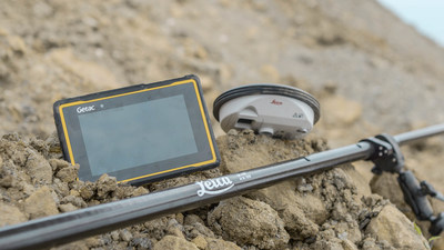
Leica Geosystems has selected Getac’s fully rugged ZX70 Android tablet for the new Leica Zeno GG04 Plus Tablet package, designed for utilities, public services, transportation and construction.
The new partnership will allow Leica Geosystems to bring comprehensive geospatial data-collection capabilities to its customers in all terrains and weather conditions, according to a Getac news release.
Leica Geosystems selects Getac’s ZX70 tablet To power its new Zeno GG04 Plus Tablet solution. (PRNewsfoto/Getac)
The Zeno Mobile data collection app and Zeno GG04 plus smart antenna are designed to help customers capture highly accurate geospatial data quickly and effectively in the field.
By combining these products with Getac’s ZX70 Android tablet, Leica Geosystems has created a solution that offers measurement accuracy, connectivity and durability in a single, comprehensive package, Getac said.
Compact and powerful, the Getac ZX70 is comfortable to use with one hand, making it suitable for demanding field surveying work.
Its Android operating system supports Leica’s Zeno Mobile software, allowing for high-accuracy GNSS positions to be utilized and rich attribute data to be collected easily in the field.
Any authorized Android app can also be installed on the device, depending on the required workflow or back office systems used, bringing a high level of usability and familiarity out of the box, Getac said.
Additional key features include the 7-inch IPS display, which is easy to read in all environments, including direct sunlight. The LumiBond 2.0 touchscreen allows for full operation of the tablet in the rain and with gloves on, essential for outdoor surveying work.
The Getac ZX70’s integrated 4G modem can transmit large data files quickly and easily, even from remote locations.
The fast, stable and reliable data connection allows users to effectively utilize Hexagon Geosystems’ HxGN SmartNet correction service, enabling accurate GNSS measurement to within one centimeter.
The ZX70 offers durability, connectivity and usability, and has been designed to withstand shocks, drops, rain and vibration, the company added.
A roundup of recent products in the GNSS and inertial positioning industry from the August 2018 issue of GPS World magazine.
OEM
IP Solution
With multi-constellation GNSS for internet of things (IOT) devices
The Dragonfly NB2 is a highly integrated and modular IP (internet protocol) solution optimized for Cat-NB2 (3GPP Release 14 eNB-IoT) that can seamlessly be incorporated into chips and modules by the multitude of companies looking to address the large and fast-growing cellular IoT space. GNSS hardware package. For customers developing NB-IoT products that also require GNSS capabilities, Ceva-Dragonfly NB2 includes a new power-optimized GNSS hardware package, with GNSS RF receiver and multi-constellation digital front-end. The GNSS package speeds up both acquisition and tracking tasks by up to 8 times compared to Ceva-Dragonfly NB1, enabling a host of popular NB-IoT use cases, including people, livestock and asset tracking and geofencing.
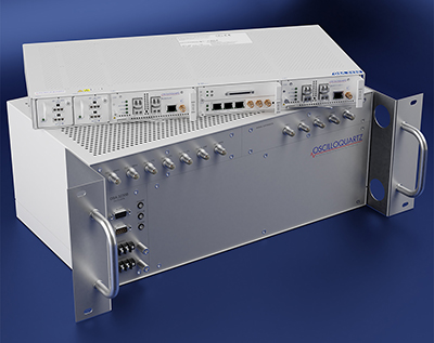
Provides timing accuracy and stability when GNSS signal is lost
Photo: Oscilloquartz
Oscilloquartz has launched its enhanced primary reference time clock (ePRTC) system to enable a high level of timing accuracy and stability, even when the GNSS signal is lost. The system provides a timing source for mission-critical transport systems, such as utility networks, government infrastructure and radio access networks, and provides the strict synchronization needed for LTE-A and 5G applications. Featuring the OSA 3230B ePRC atomic cesium clock connected to an Oscilloquartz clock combiner and grandmaster, the new solution offers the extremely stable frequency of a cesium clock with the UTC-traceable signal provided by GNSS. When combined with the OSA 5430, the OSA ePRTC system provides full hardware redundancy and multiple fan-out options including PTP over 10 Gbit/s.
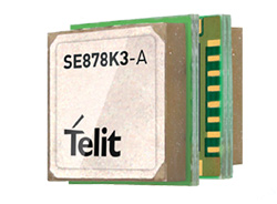
The SE878Kx-A series of GPS and GNSS integrated antenna receiver modules offer high performance, maximum reliability and low power consumption for consumer and business applications. The SE878K3-A and SE878K7-A are compatible with GPS, GLONASS, Beidou and Galileo and also enable device vendors to develop quickly and cost-effectively location-based IoT solutions for use in virtually any country worldwide. The SE878Kx-A series supports dual internal-external antennas to ensure connectivity when one is broken or compromised, along with a SAW filter to maximize jamming immunity. The modules are designed for mission-critical applications and other use cases where reliability is key, such as alarms, stolen cars or high-end asset tracking. The series also provides seamless integration with Telit’s cellular modules, including eCall/ERA-GLONASS compliant solutions.
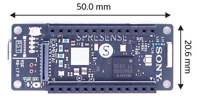
The Spresence main and extension boards are designed for internet of things (IoT) applications. The main board uses a multi-CPU structure equipped with Sony’s GNSS receiver (GPS+GLONASS) and high-resolution audio codec. A variety of systems for applications such as drones and other IoT devices can be built by combining the boards and developing the relevant applications. The boards’ software and hardware is available via open platform, allowing for a wide range of developmental possibilities. The main board can be used to control a drone using GPS positioning and a high-performance processor, voice-controlled smart speakers and low-power consumption sensing cameras. It also can be combined with sensors for use in systems that detect errors in production lines on the factory floor.
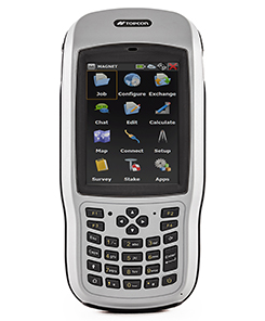
Designed for geopositioning, construction and mapping
Photo: Topcon
The T-18 handheld controller has a 3.7-inch sunlight-readable display, a 1-GHz processor and 1 GB of internal storage. For field data collection using Topcon’s MAGNET software, the T-18 offers a durable ergonomic solution with fast processing, excellent connectivity and a long (10-hour) battery life. It has a 3.5G cellular modem for connectivity with Topcon MAGNET solutions for sending and receiving data to the cloud company account. The modem also can be used for real-time kinematic (RTK) correction services. Other features include Bluetooth and an IP65 rating for dust and water protection in demanding job-site conditions.
The SXblue ToolBox is an Android application for SXblue GNSS receivers, enabling users to view and analyze the position data and metadata related to its location. The user can send commands that enable or disable some features, including systems in use, mask angle or differential angle, and constellation in use, including GPS, GLONASS, Galileo, BeiDou and SBAS. The SXblue ToolBox is also an NTRIP client capable of connecting to a NTRIP server for real-time kinematic (RTK) corrections, allowing the receiver to issue very accurate location information. The application can record, save and transfer raw data from the GNSS receiver, allowing post-processing on computers for surveying and geomatics professionals.The toolbox has been developed with special consideration for modern mobile devices and attention to user and dealer feedback. It includes a series of configurable audible and visual alarms for determining the thresholds of the information provided by the SXblue GNSS receiver.
The Leica RTC360 laser scanner is equipped with edge computing technology to enable fast and accurate creation of 3D models in the field. It combines high-performance laser scanning, edge computing and mobile app technologies to preregister captured scans quickly and accurately. With the push of a button, two million points per second of high dynamic range imagery can be captured to create a full-dome scan in under two minutes. It features a visual inertial system that automatically tracks movements between setup positions. The scans captured can be combined and preregistered on a mobile device, where they can be viewed and augmented with information tags.
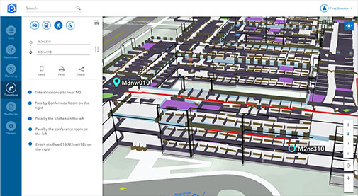
Location technology allows users to see rooms, gates and offices
Screenshot: Esri
ArcGIS Indoors is designed to enable interactive indoor mapping of corporate facilities, retail and commercial locations, airports, hospitals, event venues, universities and more. The solution applies the latest location technology to allow users to see and share where assets, rooms, departure gates and offices are located. It uses data streams, real-time processing and location intelligence tools to help businesses and other organizations understand how to better coordinate space and other resources with their facilities and campuses. Insights from sensor networks deliver real-time information to managers and executives through interactive dashboards, while visitors and employees can find useful information about the buildings they occupy. The solution also allows users to quickly access and explore critical business information, such as the location and status of fire extinguishers and their last inspection dates.
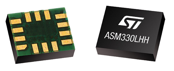
Meets demands for continuous, accurate vehicle location
The ASM330LHH module. (Photo: STMicroelectronics)
The automotive-grade ASM330LHH six-axis inertial sensor is designed for super-high-resolution motion tracking in advanced vehicle navigation and telematics applications. It lets advanced dead-reckoning algorithms calculate precise position from sensor data if satellite signals are blocked, such as in urban canyons, tunnels, covered roadways, parking garages or dense forests. Its advanced, low-noise, temperature-stable design enables dependable telematics services such as e-tolling, tele-diagnostics and e-Call assistance. Precision inertial data in six axes also meets the needs of advanced automated-driving systems. Automotive component manufacturer Magneti Marelli has selected the ASM330LHH for advanced telematics systems, to be fitted as original equipment by global automotive groups in upcoming vehicle ranges.
Esri and Waze smart cities partnership grows. (Image: Esri)
The free crowdsourced traffic and navigation app Waze is now fully supported by ArcGIS Online, where its live feed of mapped traffic alerts and other information, such as accidents, congestion and street damage, can be used in applications in minutes. Waze Live Alerts, available in ArcGIS Marketplace, is free to members of the Waze Connected Citizens Program. The program, a two-way sharing of publicly available traffic and road condition information, offers governments a stream of data, constantly updated in real time. This enables personnel to make data-driven infrastructure decisions and improves the efficiency of incident response.
Traffic engineers can use the data to analyze problems on the road and create targeted solutions.
Open-source platform for autonomous delivery and other iot
The AGL platform provides Mercedes-Benz Vans with the ability to create autonomous delivery robots. (Image: Daimler)
Automotive Grade Linux (AGL) is a collaborative cross-industry effort to develop an open platform for the connected car. Mercedes-Benz vans are using AGL as a foundation for a new onboard operating system for its commercial vehicles. The Mercedes-Benz “adVANce” initiative focuses on connectivity and internet of things (IoT) applications, innovative hardware solutions, new on-demand mobility and rental concepts, and fleet management solutions. The AGL platform provides Mercedes-Benz Vans with the flexibility to rapidly create tailored solutions for customers, including adding and connecting any kind of IoT component to the vehicle, such as sensors, automation controls and actuators. The new AGL-based operating system will debut on various Mercedes-Benz Vans prototype projects later this year.
eCyber is an integrated hardware-software product that protects vehicles against ransomware and other cyber-attacks. It can be installed in a vehicle by authorized parties, such as vehicle importers and fleet managers, in the aftermarket stage after the vehicle has left the factory, as well as by the OEM itself during manufacture. eCyber, a combined hardware and software solution in a compact box, is installed between the vehicle’s external communications device and the vehicle’s CAN (Controller Area Network) bus. It provides a secure gateway for outside communications to the CAN bus, allowing only communications with predefined parameters and values to go through. It blocks any unrecognized communications to and from the CAN bus, so no malicious digital communications can disrupt vehicle function.
Engineered for UAV-imaging missions, the iXM 100MP is a high-productivity metric camera with a range of high-resolution lenses. It is ready for integration with various UAV platforms, including Phase One’s DJI Matrice 600 Pro. The camera incorporates a medium-format sensor with backside-illumination technology, enabling high light sensitivity and extended dynamic range. Phase One also offers four new RSM lenses — with focal lengths ranging from 35mm to 150mm — to fit the new sensor’s 3.76 μm pixel size and 33 x 44 mm frame size. The lenses are available with either fixed-focus or motorized-focus functionality. The fixed-focus 35mm and 80mm lenses are especially suitable for surveying applications.
For quick approval of flights over controlled airspace
Screenshot: Skyward
Commercial drone operators in California and Hawaii — as well as a few areas in Nevada, Utah and Arizona — can get quickly authorized to fly in controlled airspace using the LAANC (Low Altitude Airspace Notification Capability) platform. Skyward is an FAA-approved airspace vendor. With Skyward, pilots with a Part 107 license can get permission to fly in regulated airspace in seconds compared to manual authorizations that can take months. This makes it significantly easier for businesses of all sizes, particularly in the construction and warehousing industries, to manage a fleet of drones to access valuable, cost-saving data. Skyward’s LAANC expansion includes airspace in the busy metro areas of Los Angeles, the Bay Area, San Diego, Las Vegas and more than 50 smaller air markets.
HxGN SmartNet has partnered with AZGPS LLC to expand access to quality network correction services for GNSS users in the southwestern United States.
HxGN SmartNet, a high-precision, high-availability GNSS network correction service, is provided by Hexagon’s Geosystems division. AZGPS, based in Florence, Arizona, serves professionals across Southern California and Arizona who rely on high-precision GNSS with network correction services, professional support and training.
The company will remain the local point of contact in the region and now has access to the infrastructure and resources of HxGN SmartNet, including HxGN SmartNet stations and a wide array of Hexagon services.
“Our number-one goal is to help our customers succeed,” said Travis Thompson, AZGPS. “The ability to leverage the resources of HxGN SmartNet will enable AZGPS to provide even more benefits to GNSS users. We look forward to continuing the superior service our customers have come to rely on for more than 13 years while staying on the leading edge of technology.”
HxGN SmartNet is fully open to all makes and models of GNSS equipment and is designed to provide the highest reliability and accuracy 24/7. Launched in 2010, HxGN SmartNet is a commercial GNSS network that offers a single connection point for coverage across North America.
Built on the most advanced GNSS reference station software platform in the world, Leica Geosystems GNSS Spider, HxGN SmartNet provides high-precision, high availability network real-time kinematic (RTK) corrections for any application, the company said.
A variety of different subscription plans are available at the state, regional and national level for any application requiring precision GNSS corrections. With more than 1,300 stations in 45 states and eight provinces, HxGN SmartNet North America offers extensive network coverage.
“GNSS users across all applications know they can rely on HxGN SmartNet to make the investments and partnerships needed to provide the easiest, fastest and most precise positions in the industry,” said Wendy Watson, director of operations for HxGN SmartNet North America. “AZGPS has a long track record of providing excellent service to GNSS users in the Southwest through the AZGPS and CALVRS networks. This cooperation between two familiar names in the positioning services industry underscores HxGN SmartNet’s commitment to ‘any constellation, any application and open to all.’”
Hexagon AB has launched the Leica RTC360, a laser scanner equipped with edge computing technology to enable fast and accurate creation of 3D models in the field. The Leica RTC360 is one of many innovations showcased at HxGN Live 2018, the company’s annual digital technology conference.
According to Hexagon, the Leica RTC360 combines high-performance laser scanning, edge computing and mobile app technologies to pre-register captured scans quickly and accurately. With the push of a button, two million points per second of high dynamic range imagery can be captured to create a full-dome scan in under two minutes, Hexagon added.
In addition, the laser scanner features a visual inertial system that automatically tracks movements between setup positions. The scans captured by the Leica RTC360 can be combined and pre-registered on a mobile device, where they can be viewed and augmented with information tags.
“We designed the Leica RTC360 for maximum productivity. For construction professionals, plant operators, public safety officials and other professionals who face complex projects with tight constraints, it provides a better way to digitally capture the reality of their sites — and process and visualize that data for faster, immediate decision making,” said Ola Rollén, Hexagon president and CEO. “What these professionals do on site every day is challenging, and we aim to continue to make their work quicker, easier and more accurate.”
Hexagon AB provides digital solutions that create autonomous connected ecosystems, a state where data is connected seamlessly through the convergence of the physical world with the digital, and intelligence is built-in to all processes.