Hexagon’s Autonomy and Positioning division has launched its first autonomy positioning and sensing kits for the agriculture market and validated these solutions in its new autonomous research and development tractor.
Through collaboration between NovAtel and AutonomouStuff, both part of Hexagon, the autonomous positioning and sensing kits were developed as part of Hexagon’s Smart Autonomous Mobility solutions portfolio launched at CES in early 2020. NovAtel and AutonomouStuff created the solutions with agriculture machinery OEMs and robotic machinery manufacturers in mind.
As a demonstrator vehicle for Smart Autonomous Mobility, the autonomous tractor features object detection and classification, simultaneous relative localization and mapping, absolute positioning through GNSS technology, and localization sensor fusing. Built to illustrate the viability of new positioning and sensing kits, the tractor incorporates safety-critical learnings with situational and environmental awareness, and manual remote control when needed. This platform validates how these solutions and capabilities accelerate autonomous development.
Hexagon’s autonomous research and development tractor validated the new kit. (Photo: Hexagon)
The positioning and sensing kits are optimized for autonomous agriculture applications, including products like the Smart7 antenna and autonomous robotic capabilities through the NovAtel OEM7 driver powered by the Robot Operating System (ROS). The kits also feature TerraStar GNSS Correction Services, ALIGN heading and relative positioning firmware, and SPAN GNSS+INS technology. Though designed for agriculture, the kits integrate seamlessly into other off-road autonomy applications.
“These positioning and sensing kits provide developers with technology bringing assured positioning to autonomy in agriculture,” explained Michael Martinez, agriculture segment manager at Hexagon | NovAtel. “Robotic-machinery manufacturers or those experienced in autonomy may be unfamiliar with the unique challenges facing agriculture applications. Conversely, those experienced with agriculture may not have the expertise to integrate positioning and sensing products within autonomous solutions. We can help in both cases through these positioning and sensor kits, as demonstrated by our autonomous tractor.”
The new autonomous positioning and sensing kit. (Photo: Hexagon)
“We’re excited to use this tractor as a platform to validate the human identification, obstacle detection and enhanced environmental awareness that our sensing kits add to our assured positioning solutions in agriculture,” said John Buszek, VP of products and services at Hexagon | AutonomouStuff. “The sensing and positioning technologies we’ve integrated on this demonstration platform showcase the Smart Autonomous Mobility portfolio, which enables and accelerates the development of autonomy in agriculture applications from prototyping to production.”
For more than 30 years, NovAtel has delivered GNSS positioning solutions as a trusted provider for top precision agriculture companies. Combined with AutonomouStuff’s decade of expertise in autonomy and sensor fusion, they significantly reduce the barrier of entry into autonomy to accelerate the time to market for autonomous solutions in agriculture, construction, mining and other off-road applications.
Learn more about their agriculture autonomy capabilities by taking a virtual tractor tour via their 3D interactive app or online at novatel.com/ag-autonomy.
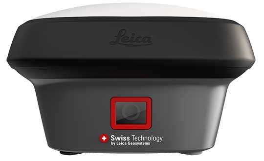
Hexagon AB has introduced the Leica GS18 I, a versatile, survey-grade GNSS RTK rover so powerful it enables surveyors to measure what they see, even structure in difficult-to-reach places, the company said.
It comes equipped with all the innovative functionality of the Leica GS18 T — Hexagon’s calibration-free, tilt-compensating GNSS solution immune to magnetic disturbances, plus the power of survey-grade visual positioning.
Through sensor fusion of GNSS, motion (IMU) and image (camera) technology, the Leica GS18 I enables the measurement of points from images. The ability to capture and measure sites via images goes far beyond the advantages of the GS18 T, which introduced the quick and convenient ability to measure points in spaces that cannot be measured with vertical poles, such as building corners, walls and points underneath obstacles (for instance, cars).
With the Leica GS18 I, professionals can now map areas that are difficult to reach physically, such as trenches, high power lines and busy roads, or blocked from GNSS signals, such as areas underneath bridges or canopies — safely and effortlessly from a distance.
“With the Leica GS18 I, mapping and surveying just got simpler, safer and more productive than ever before,” said Ola Rollén, Hexagon president and CEO. “The ability to quickly document an entire area of interest without the need to switch between tools or manoeuvre through obstacles frees up equipment and crews. Additionally, the simple and intuitive workflow of the Leica GS18 I brings the versatility of visual positioning to new user segments and applications — from utility service providers to crash scene investigators.”
The Leica GS18 I enables users to measure hundreds of points within minutes. Integration with Leica Captivate field software enables intuitive onsite point measurements and quality assurance from the field.
Further measurement of the captured images is supported by integration with Leica Infinity office software, which also enables the creation of automatically registered and referenced 3D point clouds from the images in standard export formats for use in a variety of point cloud software.
The driver, developed by NovAtel engineers, provides an optimized interface enabling users to accelerate autonomous development projects by quickly incorporating NovAtel OEM7 receivers into custom applications.
The driver is available for immediate download through the new NovAtel GitHub repository or as a ROS Binary Package for direct installation.
With the release of a NovAtel-developed OEM7 driver built on ROS, developers can now confidently access the critical data needed to build autonomy algorithms for academic investigations, ride-share programs, and other applications.
Data from numerous sensors can be combined to help move projects into higher levels of autonomy faster without the need to adapt community-developed drivers. Tested using the Hexagon | AutonomouStuff platform, the driver ensures that the data received accurately reflects the output provided by the receiver, while also giving users the ability to record raw data for post-processing.
“We are excited to introduce our first purpose-built driver powered by ROS to the GitHub community. Its development is a result of collaboration between NovAtel and AutonomouStuff in support of Hexagon’s Smart Autonomous Mobility (SAM) initiative, unveiled at CES 2020 in Las Vegas,” said Miguel Amor, chief marketing officer, Hexagon’s Autonomy & Positioning division. “The SAM portfolio is a comprehensive solutions platform that brings together all the necessary sensors, software and services to make autonomous driving possible.”
The new driver is available for download on the NovAtel GitHub repository.
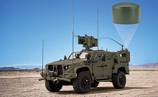
Hexagon | NovAtel launched the GAJT-410ML GPS anti-jam system in 2019. The compact design of the new, smaller version of NovAtel’s GPS Anti-Jam Technology (GAJT) can be rapidly integrated into space-constrained military vehicles (see photo). The system is easy to use while protecting GPS-based navigation and precise timing receivers (including M-code) from intentional jamming and accidental interference, according to NovAtel.
Spoofing, or the ability to give false data to a receiver, is a different challenge from jamming, with potentially even graver consequences. The GAJT portfolio provides protection from both jamming and spoofing to best defend military systems.
Spoofing Detection. As a trusted partner for guidance, navigation and control, NovAtel is developing robust spoofing detection technology that will be available in the company’s product portfolio soon. The additional spoofing information empowers users to make informed decisions about the radio frequency environment they are operating in, alerting them if malicious actors are present. This provides actionable intelligence as part of a layered approach to defend against jamming and spoofing.
NAVWAR Support. NovAtel OEM components and military off-the-shelf items are engineered to deliver precise, assured positioning and timing. Deep GNSS expertise and lean manufacturing capabilities enable the effective delivery of high-performance products in large volumes with minimal production and delivery times. This approach is combined with a high level of support to achieve low product return rates.
Railway solutions power asset management and infrastructure maintenance
Estonian Railways Ltd., a state-owned company responsible for Estonia’s railway administration, has selected Hexagon’s Geospatial division to implement a transportation system that will automate and digitize the railway’s infrastructure maintenance, construction and traffic management processes.
The combined asset management system and geographic information system (GIS) platform will help the company’s 700-plus employees efficiently manage assets and workflows.
Powered by Hexagon’s GeoTrAMS, a web-based system for tram and light-rail infrastructure, and GeoMedia, a flexible GIS management platform, Estonia Railway will be able to visualize assets on a map while integrating with other companies and external systems.
Hexagon’s state-of-the-art registry will serve multiple information systems and users at the same time, centralizing the use of asset and spatial data while avoiding data duplication and ensuring that users have access to the most up-to-date information.
“As a company, we are in a unique situation of simultaneously implementing Hexagon-specific spatial data modules for rail infrastructure management and Microsoft’s ERP for asset management, gathering and digitizing different fragmented data, unifying different workflows and applying new data management principles,” said Maia Sokk, innovation manager at Estonian Railways. “Based on our strategic goals for the next four years, we are significantly modernizing our traffic management systems. Implementing Hexagon’s technologies is an important link in this ambitious plan.”
Prior to selecting Hexagon, Estonian Railways used a fragmented system of disparate software applications to manage assets and infrastructure across its 750 miles of railroad, 129 platforms and 60 stations. With the new solution in place, Estonia Railway will be able to improve operational efficiency and transparency, better control expenses connected to the infrastructure and streamline administrative tasks.
“Estonian Railways is forward-thinking in its use of location intelligence for managing infrastructure and operations,” said Mladen Stojic, president of Hexagon’s Geospatial division. “We are excited to deliver an integrated solution that will help the railway effectively monitor and maintain its assets while also ensuring successful management of rail traffic, construction projects and services.”
Estonian Railways has been responsible for ensuring the smooth operation, management and maintenance of the country’s railway infrastructure since 1870.
Learn more about how Hexagon helps organizations close the gap between the geospatial and operational worlds with its transportation solutions.
The new version of all-in-one MultiStation addresses a wide range of needs. (Photo: Leica Geosystems)
The new Nova MS60 MultiStation combines upgraded, faster 3D laser-scanning capabilities, GNSS connectivity and digital imaging with a high-end total station. According to Leica Geosystems, part of Hexagon, the multi-station brings sensor fusion to the “next level.”
The MS60 features several laser scanning updates, including an fast scanning speed of up to 30,000 points per second, optimized scan area definitions, adapted scan managements, and an improved scanning path for zenith scans.
It is also equipped with the unique AutoHeight feature, enabling users to save time by automatically measuring the instrument’s height with a simple button press. Measurement professionals can make decisions directly in the field, performing point-cloud analysis such as flatness analysis and as-built checks in the Inspect Surface app of the MS60.
“Scan data combined with traditionally measured points, whether it’s from the total stations or the GPS receivers, is one of those immediate deliverables that help our clients see what we’re doing. With the scan data of the Leica Nova MS60 MultiStation, we can graphically show — the same day it is collecting — the locations in the field to any person,” said Donald Smith, senior land surveyor and principal at BL Companies. “When you deliver on time and provide customers with a deliverable they can see, you’ve just got yourself a recurring client.”
The MS60 speeds up workflows by combining technologies in this all-in-one instrument. The MultiStation total station offers advanced imaging, scanning capabilities and GNSS connectivity. With Leica Captivate field software, all measurement and scanning data can be visualized in 3D for quality and completeness checks.
MS60 users can seamlessly transfer all data into Leica Infinity software to manage, process, analyze and perform a quality check. The MultiStation helps users deliver projects on time, save money and have high flexibility in the field.
“The MS60 merges data in a multi-level process — total station measurements are complemented by 3D point clouds, which are automatically registered and coloured by the image information. All data perfectly fits within the same coordinate system, globally referenced by GNSS measurements or by measuring known points,” said Falko Henning, senior product manager at Leica Geosystems.
“Unlike other measurement devices, the MS60 offers familiar total station capabilities and scanning functionality to fulfil job requirements on site.” Henning said. “The operator can use the red laser pointer to perform reflectorless measurements for direct remedial work on-site or stakeout points and use the field controller even while a scan is performed.”
A roundup of recent products in the GNSS and inertial positioning industry from the January 2020 issue of GPS World magazine.
OEM
Heavy-duty antenna
For challenging environments
AT311 antenna. (Photo: CHC Navigation)
The heavy-duty CHCNAV AT311T is designed for demanding applications subject to shocks and vibrations. With advanced filtering and robust signal tracking, it provides survey-grade GNSS signals to enhance position reliability for marine applications, machine control, precision agriculture and industrial automation. Features include multi-constellation GNSS tracking using GPS, GLONASS, BeiDou, Galileo, QZSS, IRNSS and SBAS. Its IP68 water-resistant design makes it safe to use in extreme conditions with a wide temperature range (–40° C to +85° C). Its internal stacked structure enhances performance in high-interference environments, and the 40-dB signal gains, advanced signal filtering and multipath rejection design provide superior and robust GNSS signal tracking in challenging surroundings.
The UAS1 GNSS receiver module has been designed for UAV/UAS applications requiring centimeter accuracy in a small package.(Photo: Trimble)
The UAS1 compact, high-precision GNSS board was designed for unmanned aerial systems (UAS). It allows UAS system integrators to add upgradeable GNSS-based positioning using rugged connectors and Trimble’s software interface. Its 336-channel GNSS engine is capable of tracking L1/L2 frequencies from GPS, GLONASS, Galileo and BeiDou for centimeter-level, real-time kinematic (RTK) positioning. The compact board provides capabilities from high-accuracy GPS-only to full GNSS features. The receiver supports fault detection and exclusion (FDE) and receiver autonomous integrity monitoring (RAIM). System integrators also have the ability to detect interference with an RF spectrum monitoring and analysis tool embedded in the receiver.
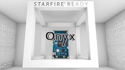
The Onyx multi-frequency GNSS OEM board offers integrated StarFire/real-time kinematic (RTK) GNSS capabilities. It features 255-channel tracking, including multi-constellation support for GPS, GLONASS, BeiDou and Galileo. It provides high performance in GNSS receiver sensitivity and signal tracking as well as patented multipath mitigation, interference rejection and anti-jamming capabilities. Through software options, the Onyx ,allows upgrades from free differential GPS signal sources such as WAAS, to increased accuracy services such as StarFire and RTK Extend. The software-enabled features are sold in bundles, but can also be purchased individually to suit changing application needs.
The OSA 5401 and OSA 5405 now enable power utility and broadcast networks to achieve sub-microsecond synchronization. (Photo: Business Wire)
The OSA 5401 and OSA 5405 upgraded PTP grandmaster clocks deliver precise, robust timing in a compact form factor. Oscilloquartz PTP timing technology enables power utility and broadcast networks to achieve sub-microsecond synchronization. The pluggable OSA 5401 is a small PTP grandmaster clock, and the OSA 5405 is an integrated PTP grandmaster with dual GNSS antenna and receiver. With spoofing and jamming detection capabilities, they also provide high availability. The OSA 5401 and 5405 provide new levels of accuracy and resilience for infrastructure and support emerging bandwidth-intensive, latency-sensitive applications. With sub-microsecond synchronization, smart grids can perform flexible, real-time decision making, as well as monitoring and automated maintenance. The OSA 5401 and OSA 5405 comply with the latest PTP profiles for time, frequency and phase synchronization in both power utility and broadcast networks. These include the IEC/IEEE 61850-9-3 Power Utility Profile for precise time distribution and clock synchronization in electrical grids with an accuracy of 1μs, and SMPTE 2059 for synchronizing video and audio equipment over packet networks.
The SBAS-capable CMA-5024 GPS has received U.S. Federal Aviation Administration (FAA) approval for installation on Boeing 737 Next-Generation aircraft. It enables B737NGs to comply with worldwide ADS-B Out mandates as well as SBAS/GPS navigation, enabling the first localizer performance with vertical guidance (LPV) approaches for B737NGs. The CMA-5024 GPS is a cost-effective alternative to replace a multi-mode receiver (MMR). The approved DO-260B ADS-B Out positioning source can be paired with any DO-260B compliant transponder, allowing operators to meet FAA and EASA ADS-B Out requirements, the UAE’s ADS-B Out and RNP requirements mandated by GCAA as well as India’s GAGAN requirements.
The U.S. Federal Aviation Administration (FAA) has approved the VTU-20 automatic dependent surveillance – broadcast (ADS-B) transmitter for airport surface management. Adhering to the performance and design assurance specifications of FAA-E-3032, the externally mounted VTU-20 ensures integration and interoperability with Airport Surface Detection Equipment, Model X (ASDE-X), Airport Surface Surveillance Capability (ASSC) and ADS-B receiver surveillance solutions for airport. The VTU-20 can be permanently or magnetically mounted to all airside vehicles, including utility, emergency, snow-removal and maintenance equipment. Each vehicle is clearly and uniquely identified, providing an essential addition to any surface movement guidance and control system.
Skyward’s Advanced Airspace Intelligence drone airspace maps provide airspace data combined with essential ground intelligence including 3D views of key structures, transmission lines, and more than a million vertical obstacles. The platform also provides access to LAANC, the Low Altitude Authorization and Notification Capability program provided by the U.S. Federal Aviation Administration. Data available for situational awareness includes vertical structure obstacles, power lines, airports, runways, national parks, stadiums, hospitals and schools.
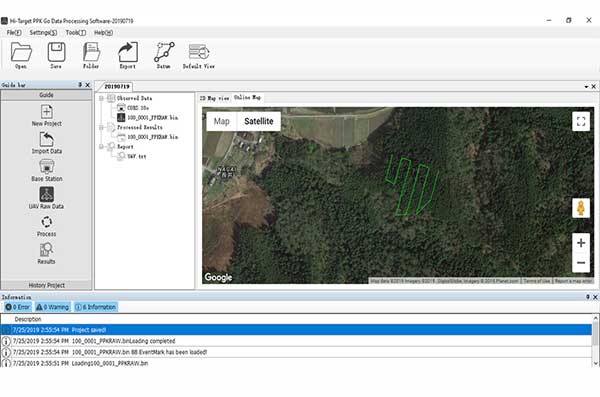
Hi-Target PPK GO precision add-on enables Phantom 4 RTK drones to achieve the accurate and reliable camera positioning data in any coordinate system without measure targets or ground control points. With 2-centimeter accuracies on XYZ, the output text file with position information or geotagged images can be used directly in major photogrammetric mapping or 3D survey software. The add-on allows selection of GPS/GLONASS/Beidou/ Galileo L1+L2+L5 and further parameter adjustments for position calculation in the PPK process to ensure the most reliable and accurate camera positioning even in poor single satellite system signals.
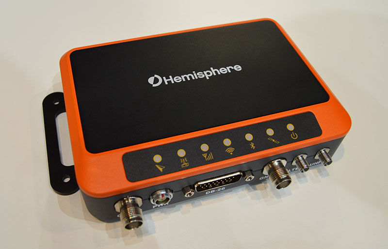
The R620 GNSS receiver is a complete refresh of Hemisphere’s previous version, the R330. (Photo: Allison Barwacz)
The next-generation R620 receiver is designed for land and marine applications requiring high-precision positioning. It is a complete refresh of the previous version (R330) and has a new low-profile ruggedized enclosure. Customers can start with sub-meter positioning accuracy and upgrade the receiver through activations and subscriptions to add functionality and improve performance capability to centimeter-level accuracy. Powered by the Vega series, the R620 GNSS receiver processes and supports more than 1,100 channels. It simultaneously tracks GPS, GLONASS, BeiDou (including Phase 3), Galileo, QZSS, IRNSS, SBAS and Atlas L-band corrections. It has status LEDs , a powerful WebUI, UHF (400-MHz and 900-MHz) radio, cellular modem, Bluetooth, Wi-Fi, Ethernet (including power over Ethernet), CAN, serial and USB.
For land surveying and geospatial information systems (GIS)
Photo: Geneq
The rugged SXPad 1500 data collector features an alphanumeric keypad and long-range Bluetooth, and was designed to meet the rigorous IP67 standard for challenging field conditions. It has a 5-inch sunlight-readable touchscreen. The SXPad 1500 can be connected to any GNSS receiver or compatible robotic total station. Driven by a 1-GHz processor and the Windows Mobile 6.5 operating system, providing the power to work with maps and large data sets in the field. Its integrated cellular modem and Wi-Fi provides wireless connectivity for internet access and GIS data transfer — helpful for configuring a real-time kinematic (RTK)-compatible GNSS receiver. Equipped with an internal memory of 1 GB (memory can be expanded to 16 GB with an SD card), the SXPad 1500 provides enough storage space for data recording. Its high-performance lithium battery allows uninterrupted field operation for up to eight hours.
The LT700H RTK Android tablet is designed to increase efficiency and productivity of the mobile field workforce in applications requiring centimeter-to-decimeter positioning accuracy. Portable, rugged and versatile, the LT700H enables precision GIS data collection, forensic mapping, construction site layout, environmental surveys, landscaping and earthmoving jobs. Powered by 184-channel high-performance GPS, GLONASS, Galileo and BeiDou module and a superior tracking GNSS helical antenna, the LT700H provides position availability in demanding environments. Its integrated 4G modem ensures seamless communication from field-to-office and robust connectivity to RTK correction networks.
The Trimble Alloy GNSS reference receiver now supports BeiDou Generation III (BDS-3) signals. This will enable operators to meet the ongoing demand from surveyors, mapping professionals and precision farmers for accurate, reliable corrections derived from real-time networks. Released in 2018, the Alloy has the processing power needed for high-quality data from multiple constellations. Alloy version 5.42 firmware tracks all available and planned GPS Block IIIA L1C and BDS-3 signals.
Hexagon showcased the Leica DSX utility detection solution at Intergeo 2019. (Photo: Allison Barwacz)
The Leica DSX utility detection solution can be used together with Leica GPS/GNSS systems to generate highly accurate, georeferenced maps. The DSX uncovers utilities for repair and maintenance, civil engineering and surveying projects. The ground-penetrating radar system includes portable hardware and software that automates data analysis and creates a 3D utility map.
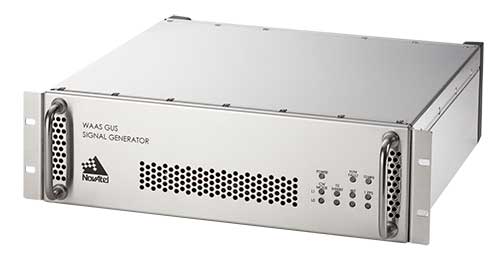
Next-generation NovAtel ground uplink station signal generators delivered for SBAS modernization
Photo: NovAtel
Hexagon/NovAtel announced that shipments of next-generation ground uplink station (GUS) signal generators have commenced in fulfillment of its contract with the United States Federal Aviation Administration (FAA) to support the FAA’s safety of life wide-area augmentation system (WAAS) navigation service.
Developed by the FAA for civil aviation, WAAS is a safety-critical navigation aid that provides integrity monitoring and differential corrections for all phases of flight. The next-generation NovAtel GUS signal generator replaces the legacy product that has operated successfully for more than 15 years and ensures continued operation for years to come.
Along with the GUS signal generator modernization, the contract includes ongoing engineering support services for the complete portfolio of NovAtel ground reference receiver products deployed by the FAA.
“We have a long-standing relationship with the FAA and worked very closely with the WAAS program team to deliver this critical next-generation technology for SBAS modernization,” stated Jonathan Auld, NovAtel Vice President of Engineering and Safety Critical Systems. “We’re very pleased to continue our commitment to support the FAA and their safety of life WAAS service.”
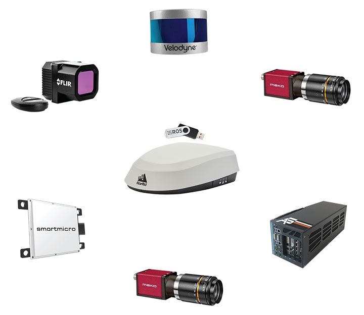
Hexagon AB, a global leader in sensor, software and autonomous solutions, introduced its Smart Autonomous Mobility solutions portfolio today at CES 2020, bringing together all the necessary sensors, software and services to make autonomous driving possible.
CES 2020, the massive annual consumer electronics show, is taking place Jan. 7-10 in Las Vegas. Hexagon’s Smart Autonomous Mobility solutions portfolio will be demonstrated in Hexagon’s pavilion CP-15.
Hexagon said it is on a mission to enable all customers to accelerate and deploy a bold autonomous mobility vision — from research and development to advanced machine learning and simulation, to full integration and production into industry ecosystems.
“Through our Smart Autonomous Mobility solutions portfolio, Hexagon is empowering an autonomous future that can transform ecosystems, protecting millions of lives and dramatically lowering carbon emissions,” said Ola Rollén, Hexagon president and CEO. “We are committed to providing complete technology solutions that enable our customers to build, test and put fully autonomous fleets to work safely.”
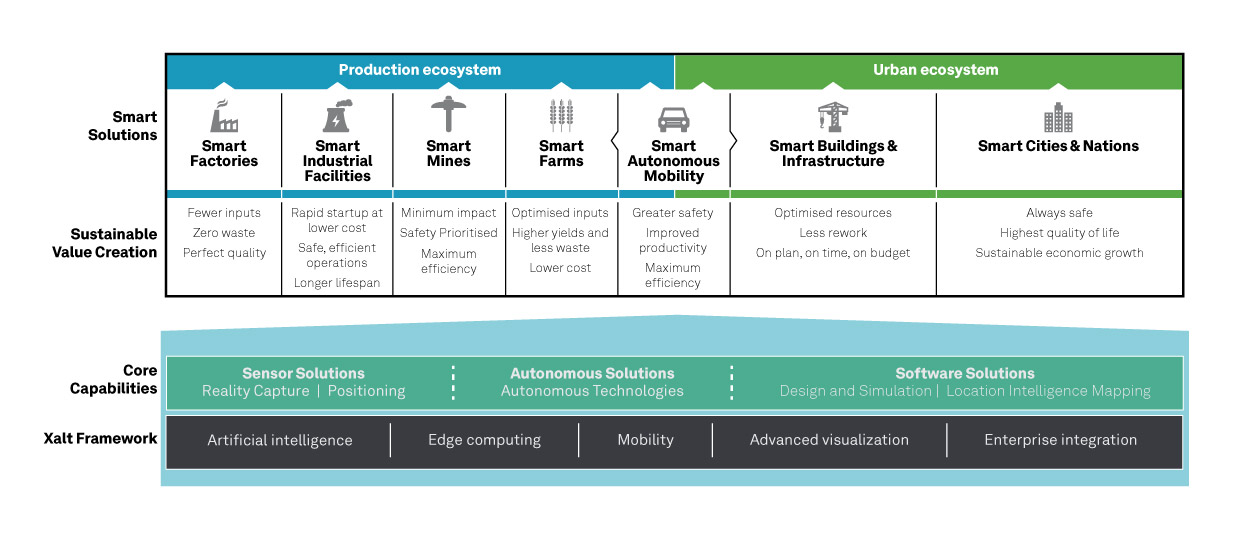
The Smart Autonomous Mobility portfolio includes three solution sets: Enable, Accelerate and Deploy.
Enable. Hexagon enables customers to fast-track R&D with hardware, software, and services to quickly enable autonomous driving systems across a variety of vehicle platforms and applications. From providing a turn-key automated driving research vehicle platform for field testing, integrating a customisable and assured positioning engine with reliable correction services, and offering baseline simulation tools and high-accuracy ground truth, Hexagon has already enabled thousands of customers worldwide with these technologies.
Accelerate. Hexagon enables customers to create Smart Digital Realities — seamless workflows between real-world and simulated environments. To drive even 20% better than a human driver requires 11 billion miles of validation, which is equivalent to 500 years of non-stop driving in the real world with a fleet of 100 cars.
With machine learning, simulation and testing for entire system performance and engineering and integration services, and high-definition digital reality capture, visualization and on-demand feature extraction, Hexagon allows customers to optimise, verify and validate the necessary billions of miles of driving required to safely deploy autonomous vehicles to the road.
Deploy. Hexagon allows customers to quickly scale from prototype and R&D phases to production for any autonomous application. The automotive-grade hardware solutions, autonomy software technologies, and functionally safe positioning solutions and services available in Hexagon’s Smart Autonomous Mobility portfolio are ready to deploy at scale for:
Mass production of passenger vehicles
Neighborhood electric vehicles (NEV)
Tractor trailers (class 8)
Off-road vehicles for mining, agriculture and defense
Hexagon showcased the Leica DSX utility detection solution at Intergeo 2019. (Photo: Allison Barwacz)
Hexagon AB presented its Smart Buildings & Infrastructure and Smart Cities & Nations portfolios at Intergeo 2019, which took place Sept. 17-19 in Stuttgart, Germany.
At the show, the company exhibited a number of its solutions designed to help manage the life of a building — from initial land surveying, through design, build, maintenance, renovation and demolition — and optimize the completion of infrastructure projects. These solutions include the Leica DSX utility detection solution, the BricsCAD building design software and HxGN SmartBuild.
Reality capture solutions showcased at Intergeo 2019 include Hexagon’s Leica BLK2GO mobile reality capture solution, the HxGN Content Program, and the Hexagon Smart M.Apps and Luciad portfolios.
“The ultimate form of data leverage is when tasks and processes become autonomous, which is the goal of our smart solutions portfolios,” said Ola Rollén, president and CEO at Hexagon. “We help customers leverage the data within their workflows to achieve the greatest efficiency, productivity and quality outcomes possible. When we collectively achieve these outcomes at scale, not only can we sustain growth for our businesses, but also this finite planet we all share…fewer resources, less waste, less pollution.”
MicroSurvey Software, part of Hexagon, has released its new field data-collection software platform for Android users.
FieldGenius for Android, version 1.0, is first release of the company’s new multi-platform field software built on the Android platform. It supports most popular GNSS sensors on the market today.
FieldGenius is third-party, brand-neutral data-collection software used by many surveyors. The new release builds on decades of innovation MicroSurvey has invested into the original FieldGenius software, providing users with an easy-to-use and intuitive mobile data-collection software package for the next generation.
New features include dynamic data panels synchronized with the map views. A fresh user interface provides familiarity for existing FieldGenius users while offering new tools, simplified workflows and readily available data that surveyors require at the point of work to make informed decisions in the field.
“Surveyors, dealers, and distributors from every corner of the world have been demanding an Android based version of MicroSurvey FieldGenius for years,” said Marc Veinotte, global sales and OEM manager at MicroSurvey. “This is the first release of our new multi-platform field data collection software that will provide a consistent user experience across a wide cross section of data collection devices. MicroSurvey continues its hardware neutrality strategy offering support for almost every brand of popular and upcoming GNSS receiver on the market today.”
Early adopters of FieldGenius for Android will receive additional benefits and participate in the newly created MicroSurvey Technology Innovation Group (MTIG).
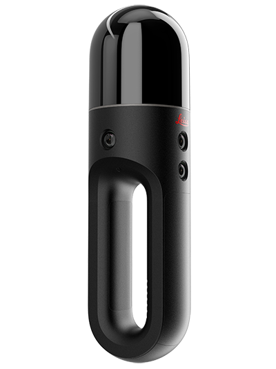
Hexagon AB has introduced two new additions to its Leica BLK series. The Leica BLK2GO is a small, portable, integrated handheld-imaging scanner, and the Leica BLK247 is a 3D laser-scanning sensor for security surveillance providing continuous, 24/7 situational awareness.
“Extending the BLK series continues Hexagon’s 20-year focus on revolutionising reality capture,” said Ola Rollén, Hexagon president and CEO. “These sensors are not only ground-breaking for their technical capabilities, but also for their practicality. The Leica BLK2GO can be taken anywhere, and the Leica BLK247 never sleeps.”
Leica BLK2GO. The Leica BLK2GO introduces mobility for scanning complex indoor environments. The handheld-imaging laser scanner combines visualisation, lidar, and edge-computing technologies to scan in 3D while in motion, allowing users to be more agile and efficient in capturing objects and spaces.
The BLK2GO has a wide range of applications from adaptive reuse projects in the architecture and design industries to location scouting, pre-visualisation, and VFX workflows for media and entertainment.
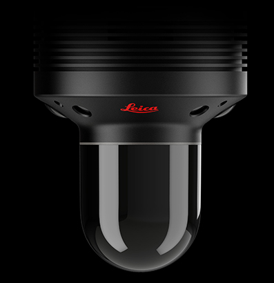
The Leica BLK247. (Photo: Hexagon)
Leica BLK247. The Leica BLK247 is designed for continuous 3D reality capture, extending capabilities for safety and security applications. The sensor provides real-time situational awareness through edge computing and LiDAR-enabled change-detection technology.
Using artificial intelligence, the BLK247 can tell the difference between still and moving objects — such as a person walking who leaves a suitcase behind — and identify security threats to provide real-time alerts for both expected and unexpected changes.
The BLK247 greatly enhances situational awareness within restricted or high-security spaces, as it eliminates the need for people to constantly monitor walls of security screens or smart building dashboards.
The Leica BLK2GO and Leica BLK247 are among the many innovative solutions showcased this week at HxGN LIVE 2019, Hexagon’s annual digital technology conference.