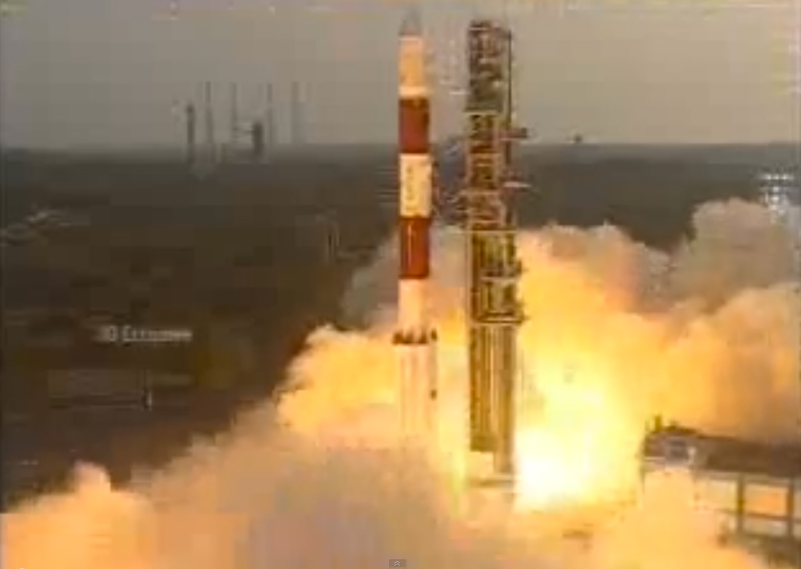
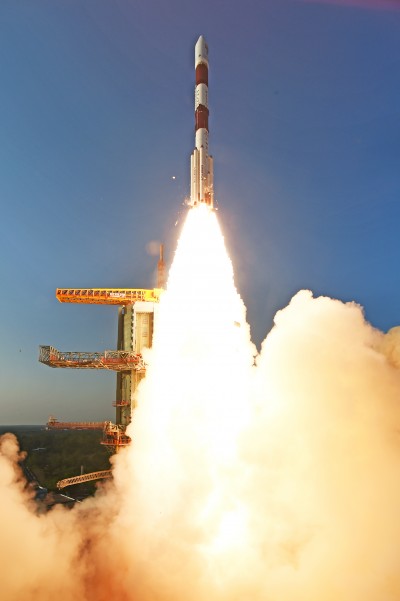
The Aug. 31 launch of a new Indian Regional Navigation Satellite System (IRNSS) satellite failed when the protective fairing did not separate.
Indian Space Research Organisation (ISRO) chairman AS Kiran Kumar confirmed that the mission to launch India’s eighth navigation satellite, IRNSS-1H, from the second launch pad at the spaceport of Satish Dhawan Space Centre, Sriharikota, was unsuccessful.
The 1425-kg satellite was expected to expand the existing seven satellites of the NavIC constellation. The launch vehicle PSLV-C39 lifted the satellite on Aug. 31 using the XL variant, of PSLV equipped with six strap-ons, each carrying 12 tons of propellant.
The three phases of the launch went smoothly, but unfortunately, the heat shield which was supposed to be separated in the fourth stage could not be detached.
IRNSS-1H was planned as a replacement satellite for IRNSS-1A.
Using UAVs, TUV India, under TÜV Nord Group, is conducting an assessment of a 25-MW solar photovoltaic (PV) power project 160 kilometers from Bengaluru spread across 90 acres. TÜV Nord Group is a technical service provider working in 70 countries.
For the Indian solar project, the first phase involved a site assessment, flight planning, undertaking drone flights, uploading data from the drone to advanced software, data processing, analysis, documentation, interpretation and delivering the final report. The second phase will take place after installation of solar modules and operation of PV power projects for at least six months.
Having executing this solar PV power project successfully with the drone, TUV India is confident it can use UAV technology for assessment, surveillance and inspection of infrastructure projects such as rail, roads, seaporta, airports and utilities.
Three atomic clocks onboard a single satellite of the NAVIC Indian regional navigation satellite system have failed.
Indian Space Research Organization (ISRO) Chairman A.S. Kiran Kumar told The Hindu newspaper that the agency is trying to restart the clocks. Kumar said the affected satellite, IRNSS-1A, is otherwise healthy, and the rest of the constellation is performing its core function of providing accurate position, navigation and time.
Last week, the European Space Agency discussed clock failures on board Galileo satellites. Rubidium atomic clocks onboard both constellations were manufactured by Spectratime of Switzerland, but the cause of the failures has not been identified and could involve factors other than clock design.
IRNSS-1A is equipped with one primary and two back-up clocks. At this time, it “will give a coarse value. It will not be used for computation. Messages from it will still be used,” Kumar said. “There are some anomalies in the atomic clock system on board. We are trying to restart it. Right now we are working out a mechanism for operating it.”
The ISRO is readying one of the two back-up navigation satellites — IRNSS-1H — to replace it in space in the second half of this year. IRNSS-1A was launched in July 2013 and has an expected lifespan of 10 years.
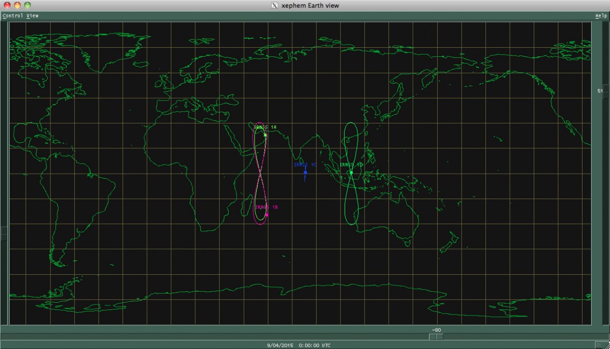
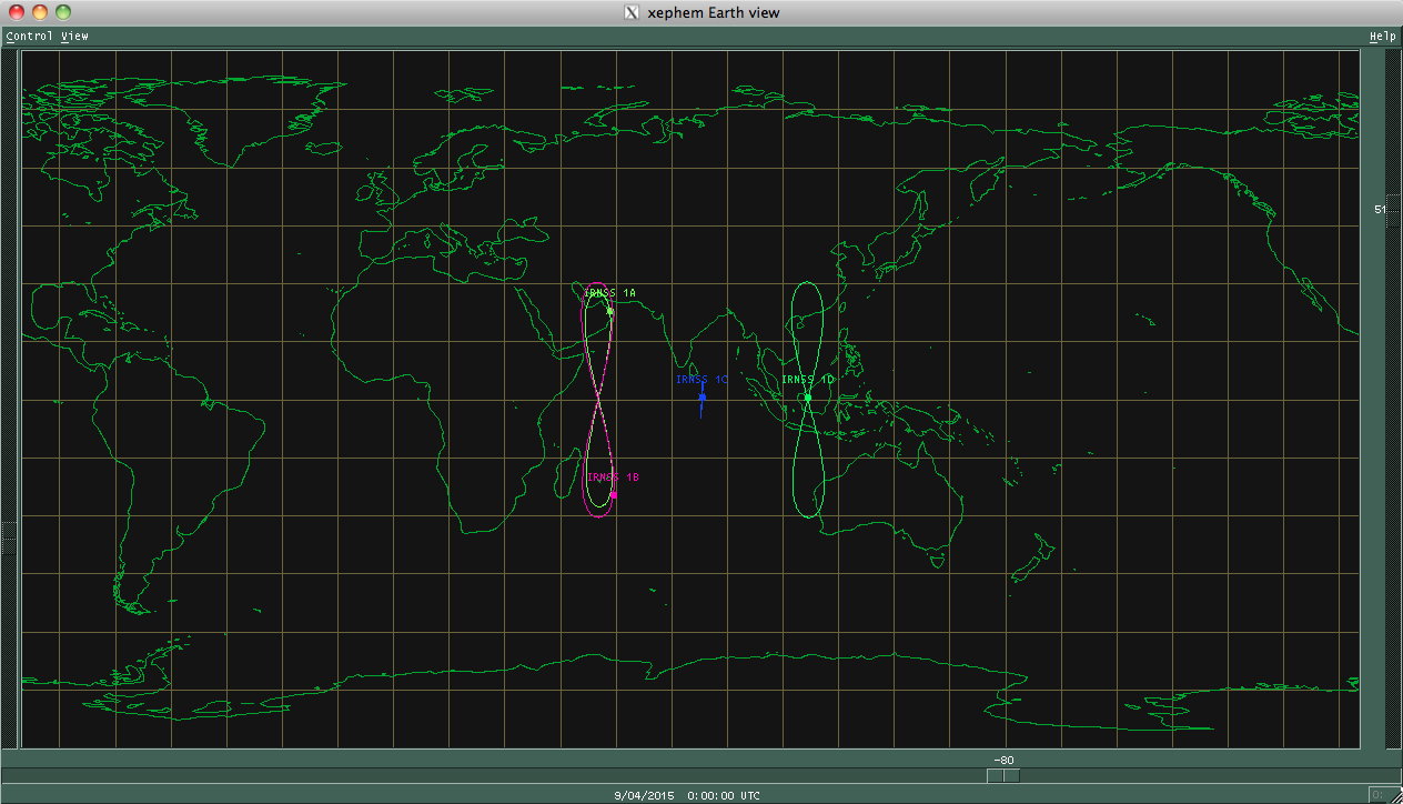
The Indian Regional Navigation Satellite System (IRNSS) constellation was completed April 28, 2016. It was then renamed NAVIC — Navigation Indian Constellation, by India’s Prime Minister Narendra Modi.
With seven satellites in orbit, the constellation’s primary focus is to provide information in the Indian region and 1,500 kilometers around the mainland.
The government of India has warned domestic airlines of “consequences” if they do not use GAGAN, the state’s GPS-Aided Geo Augmented Navigation system, reports the Mumbai Mirror.
The warning came during a meeting called by the Directorate General of Civil Aviation (DGCA) in December with all stakeholders, including the airlines. Most aircraft registered in India are still not equipped with the technology two years after its launch.
While smaller aircraft such as ATRs and Bombardiers in the Indian carriers’ fleet are already equipped with the GAGAN system, bigger planes need to be retrofitted at the airlines’ expense, including Airbus A320, A330, Boeing 737, B777 and B 787. Eight major domestic carriers — Air India, Air India Express, Jet Airways, JetLite, IndiGo, SpiceJet, GoAir, Vistara and AirAsia — have 427 such planes in service, Mumbai Mirror reports.
The National Civil Aviation Policy, announced by the government in June, makes it mandatory for all aircraft registered in India to be GAGAN-enabled by Jan. 1, 2019.
Jointly developed by Indian Space Research Organisation (ISRO) and Airports Authority of India (AAI), the GAGAN system was officially launched by Civil Aviation Minister Ashok Gajapathi Raju in July 2016. It is said to make airline operations more efficient and cut down costs as it reduces separation between aircraft, increases air safety and fuel efficiency.
GAGAN’s footprint extends from Africa to Australia and has expansion capability for seamless navigation services across the region. The system is inter-operable with other international satellite based tracking systems such as the WAAS (US), EGNOS (Europe) and MSAD (Japan).
Drones could soon be inspecting powerlines in India, thanks to a partnership between Sharper Shape and Sterlite Power.
Sharper Shape, based in Palo-Alto, California, offers automated drone-based asset inspections. Sterlite Power is a power transmission company in India.
The Sharper Shape Sharper A6 drone is designed for beyond-visual-line-of-sight (BVLOS) flights.
Sharper Shape has already spearheaded the adoption of long-distance commercial drone flights for utilities in Europe. In the U.S., Sharper Shape is part of the EEI Sharper Utility partnership, an industry collaboration aimed at demonstrating and developing commercial long-distance drone flights for electric companies.
As part of the cooperation, Sterlite Power will make a minority investment in Sharper Shape to foster Indian market growth and continued technology development. The companies signed a partnership agreement during Make in India Week in Mumbai in February, an event held to spur innovation, design and sustainability.
Sterlite Power and Sharper Shape are awaiting approvals from India’s Directorate General of Civil Aviation for large-scale, long-distance inspection flights. Long-distance drone flights could provide significant benefits with safe, efficient and fast inspections compared to manned helicopter flights.
Utilities in India. The partnership also intends to provide services for other utilities in India. India has a power transmission network of more than a million circuit kilometers, which undergoes double-digit growth annually. The use of drones will increase the uptime of the grid, reduce transmission tariffs, avoid grid blackouts, and save the environment by reducing deforestation along the line corridors.
Sterlite Power has already introduced lidar for surveys and helicopters to avoid disturbances to farm activities and speed the process to commission much-needed infrastructure in India. Soon, it will deploy heli-cranes to erect transmission towers in the challenging terrains of Jammu and Kashmir.
In the United States…
In August, Sharper Shapesubmitted a waiver application to the U.S. Federal Aviation Administration (FAA), requesting approval to perform beyond-visual-line-of-sight (BVLOS) flights. The waiver would allow members of the Edison Electric Institute (EEI)-Sharper Shape partnership to demonstrate and develop commercial long-distance flights for electric company asset inspections.
BVLOS flights are able to travel 10–20 miles, compared to roughly one-third of a mile under visual-line-of-sight regulations.
The test flights will leverage Sharper Shape’s new Sharper A6 drone and Sharperscope 5.0 payload. The A6 is optimized for BVLOS asset inspections, using four redundant cellular networks to make it virtually impossible for the drone to lose communication with ground-control operators, the company said.
Sharper Shape leverages the LTE commercial multi-billion-dollar networks, while other vendors use point-to-point, which can’t communicate beyond line of sight, or satellite connection, which suffers from high costs and invariable latency that increases the response time and impedes a pilot’s ability to make quick adjustments during flight.
The Indian Space Research Organisation (ISRO) is finalizing plans to have two spare satellites for its navigation fleet built by private industry in the next two years, reports The Hindu. The seven-satellite NAVIC (Navigation Indian Constellation) — formerly known as IRNSS — is now complete.
The Indian government will “handhold” industry for the first satellite, scheduled to be built by March 2017. The second satellite will be built entirely by industry, said M. Annadurai, director of ISRO Satellite Centre. Both 1,400-kilogram spare satellites will be kept ready on the ground.
The space agency issued “expressions of interest” in June, reports The Hindu, and ISRO is discussing details of risk, price and profit-sharing with prospective partners.
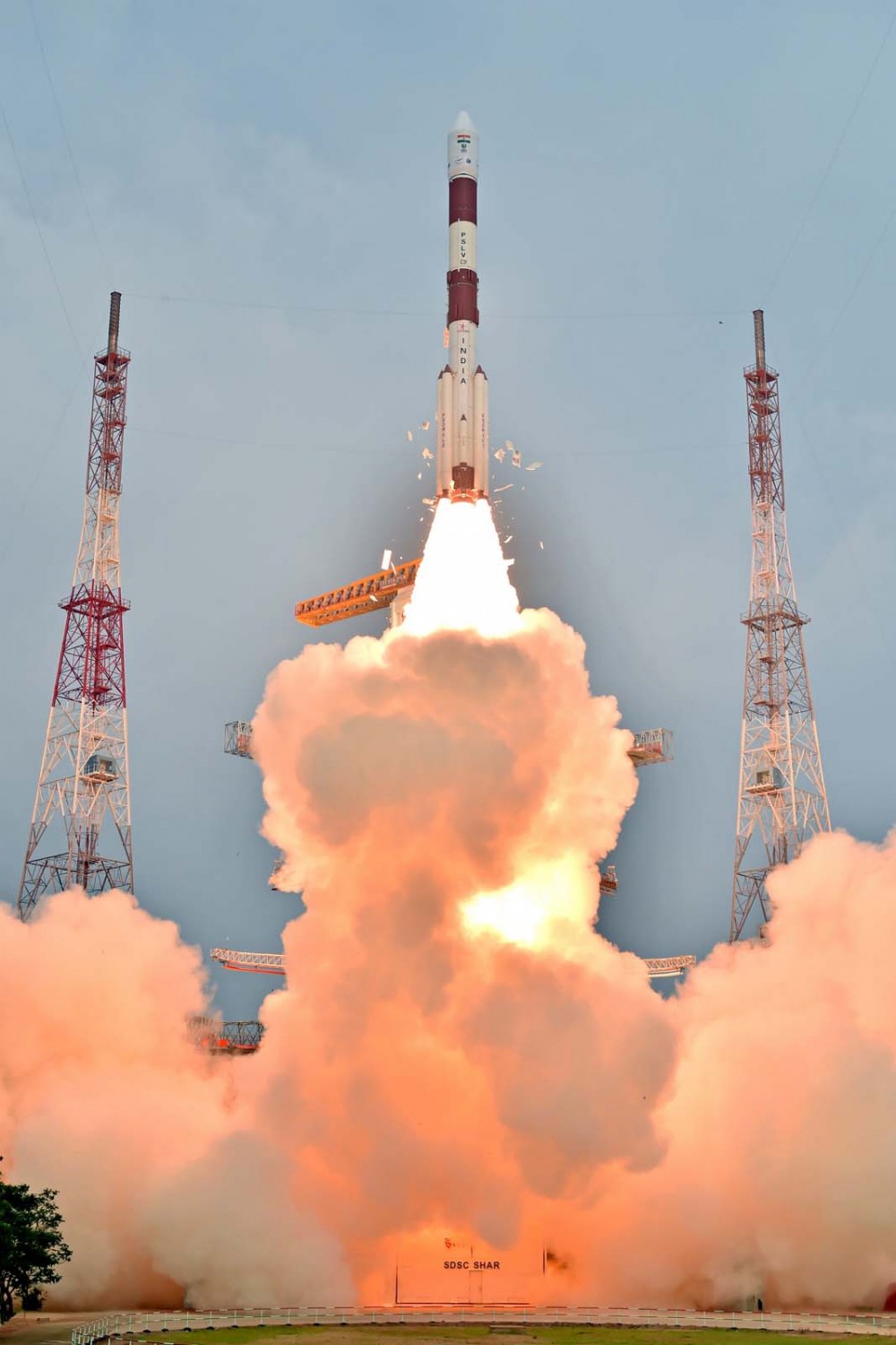
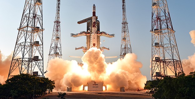
The countdown for the launch of of a rocket carrying Indian Regional Navigation Satellite Sytem-IRNSS-1F began at 9:30 a.m. local time at the Sriharikota rocket port in Andhra Pradesh, reports the New Indian Express.
The Polar Satellite Launch Vehicle (PSLV) is expected to blast off around 4 p.m. on Thursday, March 10, following a 54-hour 30-minute countdown.
“Like the countdowns for the flight of many other earlier rockets, the countdown is progressing smoothly,” a senior official of the Indian Space Research Organisation (ISRO) told the newspaper.
IRNSS-1F will be India’s sixth navigation satellite. It has a design life of 12 years and carries two payloads. The navigation payload will be operating in L5-band and S-band; the ranging payload consists of a C-band transponder (automatic receivers and transmitters of radio signals), which facilitates accurate determination of the range of the satellite.
A highly accurate Rubidium atomic clock is part of the navigation payload of the satellite. IRNSS-1F also carries Corner Cube Retro Reflectors for laser ranging.
To date India has launched five regional navigational satellites (IRNSS-1A, 1B, 1C, ID and 1E) as part of a constellation of seven satellites to provide accurate position information service to users across the country and the region, extending up to an area of 1,500 km.
The entire IRNSS constellation of seven satellites is planned to be completed in this year. The seventh satellite, IRNSS-1G, is expected to be launched in the second half of 2016. The full system comprises nine satellites — seven in orbit and two on the ground as standby.
The first satellite IRNSS-1A was launched in July 2013, the second IRNSS-1B in April 2014, the third In October 2014, the fourth in March 2015, and the fifth in January of this year.
According to ISRO, with the operationalisation of five IRNSS satellites, the proof of concept of an independent regional navigation satellite system over India has been demonstrated for the targeted position accuracy of better than 20 meters, 24 hours a day.
IRNSS-1E heads for orbit on Jan. 20. (Photo: IRNSS)
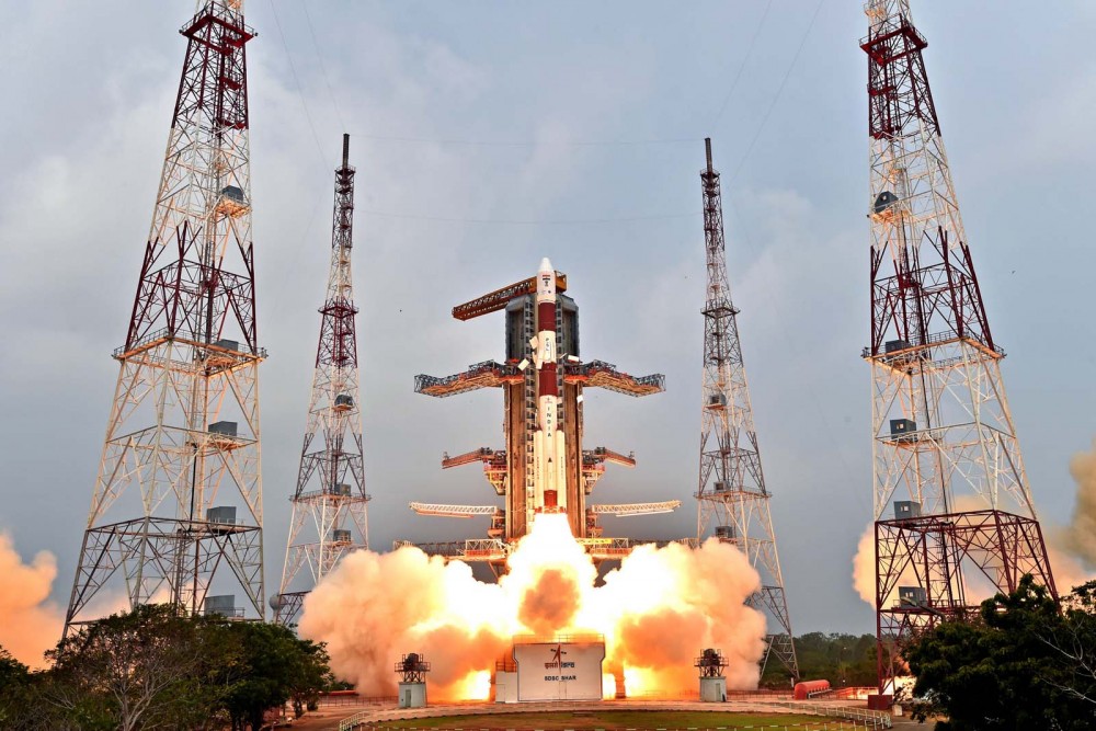
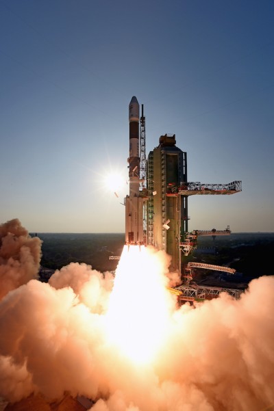
The fifth satellite in the Indian Regional Navigation Satellite System (IRNSS) constellation lifted off on time Jan. 20 from Satish Dhawan Space Center on Sriharikota Island, on India’s east coast.
As in the previous four launches of IRNSS satellites, the navigation satellite rode aboard a Polar Satellite Launch Vehicle (PSLV). This is the 33rd launch for the PSLV.
After the PSLV-C31 lift-off at 0401 GMT Wednesday (11:01 p.m. EST Tuesday) with the ignition of the first stage, the subsequent important flight events — strap-on ignitions and separations, first stage separation, second stage ignition, heat-shield separation, second stage separation, third stage ignition and separation, fourth stage ignition and satellite injection — all took place as planned.
After a flight of about 18 minutes 43 seconds, IRNSS-1E Satellite was injected to an elliptical orbit of 282.4 km X 20,655.3 km inclined at an angle of 19.21 degree to the equator (very close to the intended orbit) and successfully separated from the PSLV fourth stage.
After injection, the solar panels of IRNSS-1E were deployed automatically. ISRO’s Master Control Facility (at Hassan, Karnataka) took over the control of the satellite. In the coming days, four orbit manoeuvres will be conducted from Master Control Facility to position the satellite in the geosynchronous orbit at 111.75 deg East longitude with 28.1 deg inclination.
IRNSS-1E is the fifth of the seven satellites constituting the space segment of the Indian Regional Navigation Satellite System. IRNSS-1A, 1B, 1C and ID, the first four satellites of the constellation, were successfully launched by PSLV on July 02, 2013, April 04, 2014, October 16, 2014 and March 28, 2015, respectively. All the four satellites are functioning satisfactorily from their designated orbital positions.
IRNSS-1E, the fifth satellite in India’s regional constellation, lifted off Jan. 20. (Photo: IRNSS)
IRNSS is an independent regional navigation satellite system designed to provide position information in the Indian region and 1500 km around the Indian mainland. IRNSS would provide two types of services, namely, Standard Positioning Services (SPS) — provided to all users — and Restricted Services (RS), provided to authorized users.
A number of ground stations responsible for the generation and transmission of navigation parameters, such as satellite ranging and monitoring, have been established in 18 locations across the country. In the coming months, the remaining two satellites of this constellation, namely, IRNSS-1F and IG, are scheduled to be launched by PSLV, thereby completing the entire IRNSS constellation.
G. Satheesh Reddy, a scientist with the Defence Research and Development Organisation (DRDO) of India, has been appointed as the scientific advisor to the defense minister of India, a secretary-level appointment with the government of India. The DRDO is an agency of the Republic of India responsible for the development of technology for use by the military, headquartered in New Delhi.
Reddy is an expert in navigation technologies. He joined DRDO in 1986 and led the conceptualization, design, development and production of inertial sensors, navigation schemes, algorithms and systems, calibration methodologies, sensor models and simulation, along with development of satellite navigation receivers and hybrid navigation systems. Under his leadership, advanced products and varieties of avionics systems have been produced and successfully flight tested in strategic programs of India.
As project director, Reddy led the design and development of ring laser gyro-based INS System, MEMS-based INS systems, the sea-guard reference system and the ship navigation system, strengthening the country’s self reliance in high-accuracy and long-range navigation. He also helped develop a 1000-kg class guided bomb.
Reddy graduated in electronics and communication engineering from JNTU, Anantapur, and received his master of science and doctorate from Jawaharlal Nehru Technological University, Hyderabad. He is a Fellow of Indian National Academy of Engineering (FNAE), the Royal Institute of Navigation London (FRIN), and the Royal Aeronautical Society London (FRAeS). He has been awarded Full Member Diploma and inducted as a Foreign Member of the Academy of Navigation & Motion Control, Russia, and is an Associate Fellow of the American Institute of Aeronautics & Astronautics (AFAIAA) of the United States.
The fourth satellite in the Indian Regional Navigation Satellite System, launched on March 28, has arrived at its designated orbital slot.
Based on data supplied by the U.S. Joint Space Operations Center, IRNSS-1D is in an inclined geosynchronous orbit with an inclination of 30.5 degrees and a nodal longitude of 111.7 degrees east, within the allowed limits of the assigned longitude of 111.5 degrees east.
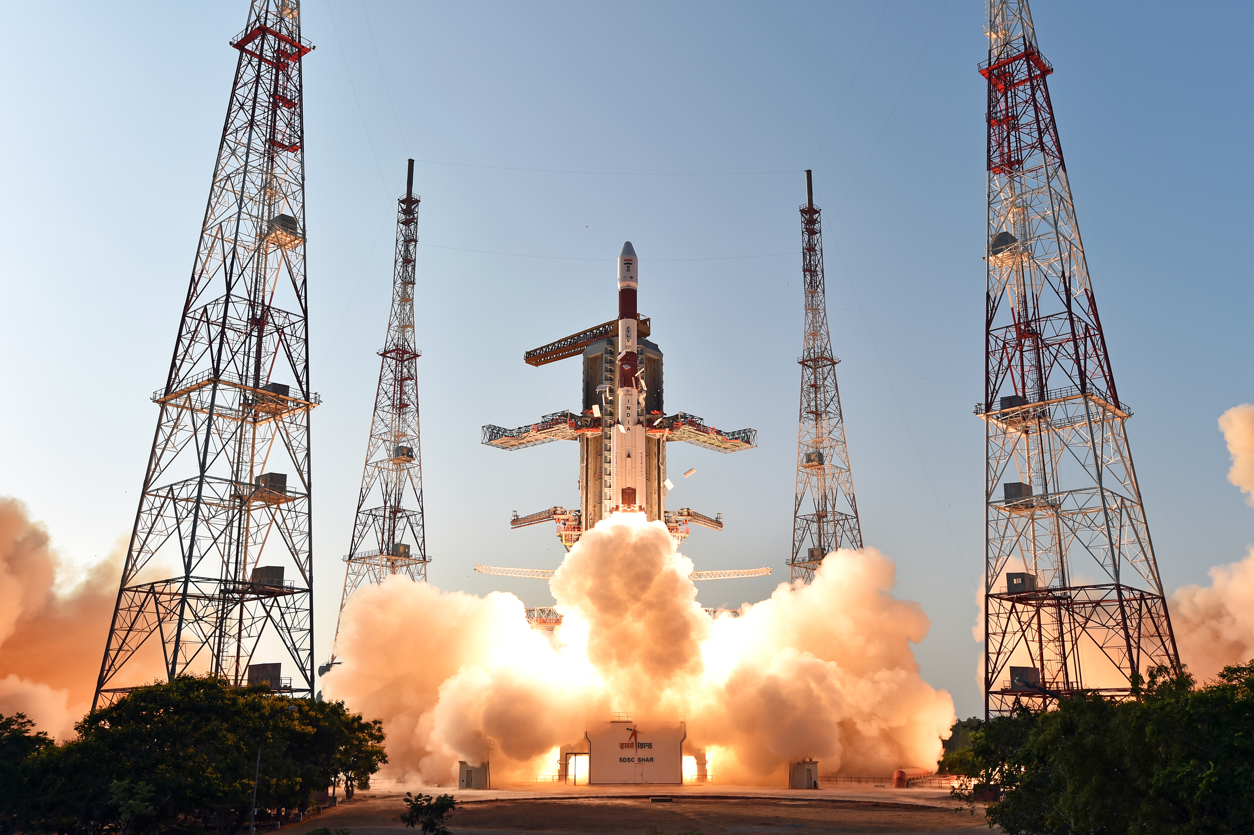
The fourth satellite of IRNSS satellite navigation constellation, IRNSS-1D, was launched onboard PSLV-C27 on Saturday, March 28, according to the Indian Space Research Organization (ISRO). The Polar Satellite Launch Vehicle blasted off at 11:49 GMT (7:49 a.m. EST), or 5:19 p.m. local time, at the Satish Dhawan Space Center on India’s east coast.
This is the fourth successful launch of a navigation satellite in less than a week, following GPS IIF-9 on Wednesday and Galileo 7 and 8 on Friday. A fifth navigation satellite, for the BeiDou constellation, is expected to launch tomorrow.
This is the 28th consecutively successful mission of the PSLV, the ISRO said. The “XL” configuration of PSLV was used for this mission. Previously, the same configuration of the vehicle was successfully used seven times.
After the PSLV-C27 lift-off with the ignition of the first stage, the subsequent important flight events took place as planned. After a flight of about 19 minutes, 25 seconds, the IRNSS-1D satellite was injected to an elliptical orbit of 282.52 km X 20,644 km, very close to the intended orbit, and successfully separated from the PSLV fourth stage.
After injection, the solar panels of IRNSS-1D were deployed automatically. ISRO’s Master Control Facility (at Hassan, Karnataka) took over the control of the satellite. In the coming days, four orbit maneuvers will be conducted from the Master Control Facility to position the satellite in geosynchronous orbit at 111.75 degrees East longitude with 30.5 degrees inclination.
IRNSS-D is the fourth of seven IRNSS satellites to be launched to provide navigational services to the region, according to the ISRO. The satellite was placed in geosynchronous orbit. Predecessors IRNSS-1A, 1B and 1C were launched by PSLV-C22, PSLV-C24 and PSLV-C26 in July 2013, April 2014 and October 2014 respectively. All the satellites are functioning satisfactorily from their designated orbital positions.
The IRNSS navigational system is regional, and targeted towards South Asia. The satellite will enable navigation, tracking and mapping services.
The next satellite, IRNSS-1E, is scheduled to be launched by PSLV. The entire IRNSS constellation of seven satellites is planned to be completed by 2016.
The launch of India’s fourth Navigation Satellite, IRNSS-1D, is now scheduled for 17:19 IST (11:49 UTC) on Saturday, March 28, from Satish Dhawan Space Centre, Sriharikota.
The launch was previously scheduled for March 9, then postponed until March 29 to replace a faulty telemetry transmitter on the satellite, according to the Indian Space Research Organization.
IRNSS-1D will be fourth in the seven-spacecraft Indian Regional Navigation Satellite System constellation. It will be flown into space in the Indian Polar Satellite Launch Vehicle-XL.
The space segment of the IRNSS consists of seven satellites: three in geostationary orbit and four in inclined geosynchronous orbit. The ground segment consists of infrastructure for controlling, tracking and other facilities. The entire IRNSS constellation of seven satellites is planned to be completed by 2015.
Both IRNSS-1A and 1B are functioning satisfactorily from their designated geosynchronous orbital positions. The first three satellites in the IRNSS series were launched from Sriharikota on July 1, 2013, April 4, 2014, and October 16, 2014. IRNSS-1E and IRNSS-1F satellites are expected to be launched before year end.
IRNSS is an independent regional navigation satellite system designed to provide position information in the Indian region and 1,500 kilometers around the Indian mainland. IRNSS will provide two types of service: Standard Positioning Services (SPS) — provided to all users — and Restricted Services (RS), provided to authorized users.