The Director General of Civil Aviation (DGCA) of India certified on December 30 the GAGAN system to RNP0.1 (Required Navigation Performance 0.1 Nautical Mile) service level, according to The Hindu.
Now aircraft equipped with Satellite Based Augmentation System (SBAS) receivers will be able to use GPS-Aided Geo Augmented Navigation (GAGAN) signals in Indian airspace for en route navigation and non-precision approaches without vertical guidance.
Mission control centers, along with associated uplink stations, have been set up at Kundalahalli in Bangalore. Another control center and uplink station are in Delhi. A top official of the AAI said one of the Reference Stations has been housed outside the premises of the Thiruvananthapuram airport. The reference stations pick up signals from the orbiting GPS satellites. The measurements are immediately passed on to the mission control centers that then work out the necessary corrections that must be made. Messages carrying those corrections are sent via the uplink stations to the satellites in geostationary orbit that have the GAGAN payload.
The availability of the GAGAN signal in the country’s air space will bridge the gap between European Union’s European Geostationary Navigation Overlay Service (EGNOS) and Japan’s Multi-functional Satellite Augmentation System (MSAS) coverage areas.
The SBAS consists of 15 Indian Reference Stations, three Indian Navigation Land Uplink Stations, three Mission Control Centers, three Geo-Stationary Navigation Payload in C and L bands and with all the associated software and communication links.
GAGAN will provide augmentation service for GPS over India, the Bay of Bengal, South East Asia and the Middle East expanding up to Africa.
By Richard Langley, Steffen Thoelert, and Michael Meurer
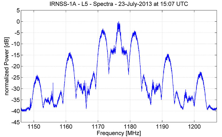
The spectrum of signals from IRNSS-1A, the first satellite in the Indian Regional Navigation Satellite System, as recorded by German Aerospace Center researchers in late July, appears to be consistent with a combination of BPSK(1) and BOC(5,2) modulation.
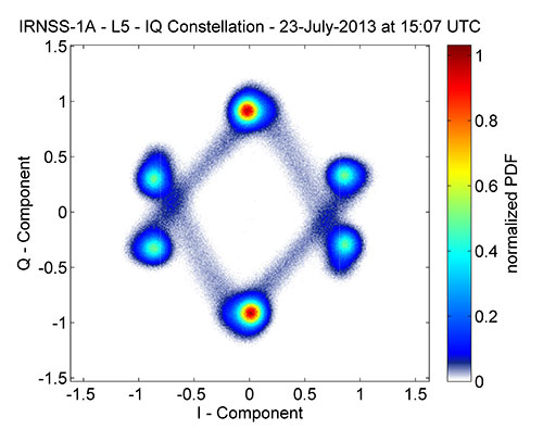
Figure 1 shows that, centered at 1176.45 MHz, the signal has a single symmetrical main lobe and a number of side lobes characteristic of the signal structure that the Indian Space Research Organization (ISRO) announced would be used for IRNSS transmissions in the L-band. Figure 2 shows the corresponding IQ constellation diagram. Further analysis will be required to sleuth additional signal details as ISRO, so far, has not publicly released an IRNSS interface control document describing the signal structure in detail.
Figure 1. Spectrum of IRNSS-1A L5 signal.Figure 2. IQ constellation diagram of IRNSS-1A L5 signal.
The German scientists caution that “this is a very early snapshot of the current signal transmission and probably both the signal power and the signal quality will change and possibly improve during the in-orbit-testing phase of the satellite’s operation.
Extra Life for IIRs, IIR-Ms
U.S. Air Force engineers are testing on-orbit a technique to extend the life of the 19 GPS IIR and IIR-M satellites on orbit, roughly 60 percent of the current contellation.
A new charging method may reduce the rate of satellite battery degradation, thereby extending satellite operational life. If the technique passes the test, the initiative could add a combined 20 years to the life of the satellites — saving the Air Force tens of millions of dollars in the process.
Gen. William Shelton, commander of Air Force Space Command, credits Capt. Jacob Hempen of the Air Force’s 2nd Space Operations Squadron for the job. Capt. Hempen says in turn that Warren Hwang of the Aerospace Corporation originated the idea.
When satellite solar panels are directly exposed to the Sun, they charge satellite batteries while continuing to power other operations onboard the space vehicle. When the satellite passes into the Sun’s shadow behind the Earth, it runs on batteries. The batteries can be re- charged at variable rates. When some of the batteries are powered above a certain rate threshold, they can overheat, accelerating their natural rate of decay.
Lowering battery charging rates could still enable the satellites to perform well while minimizing the rate of degradation. Hitting the optimum number called for some finely-honed calculations.
The satellites were built by Lockheed Martin Space Systems, and the oldest still in operation was launched in 1997.
They had an intial design life of eight years, which many have now well outlasted. If the technique proves out and is carefully applied across the board, it could conceivably fill in replenishment gaps equivalent more than two additional spacecraft — conceivably as much hundreds of millions of dollars in build and launch costs, postponed. In today’s budget environment, a postponement can be construed as equivalent to outright savings.
System Briefs
GLONASS Partial Make-Good. Russia will launch two GLONASS satellites later this year to make up for the loss of three satellites in the July 2 Proton rocket explosion. The first is scheduled for the beginning of September, and the second at the end of October. Both will rise aboard Soyuz carrier rockets, which have proven more reliable than the Protons. A constellation of 29 GLONASS satellites is now in orbit, with 24 spacecraft in operation, three spares, one in maintenance, and one in test flight phase.
Meanwhile, plans to reduce GLONASS funding have alarmed at least some deputies of the Duma, the Russian state legislative body. Government officials have floated a plan to reduce funding of the space program in 2014 by 11.7 billion rubles ($355 million), by 13.5 billion rubles in 2015, and by 40 billion rubles in 2016. The federal space program of Russia for 2006-2015 already lacks 10.5 billion rubles funding, and this year there has been a 2.3-billion-ruble additional reduction in R&D. A Duma committee chairperson warned that this trend will “lead to the loss of confidence of the international community in the GLONASS system and, consequently, to a reduction in its use globally. Russia will lose a strategic global instrument of political and economic prestige.” The Duma has recommended that the government maintain funding of federal space programs.
Galileo Satellites’ Trial By Noise. The first Galileo Full Operational Capability (FOC) satellite successfully completed acoustic testing in July, part of a full-scale test campaign at ESA’s ESTEC Test Centre in Noordwijk, the Netherlands.
The satellite was placed in the Large European Acoustic Facility (LEAF), effectively the largest sound system in Europe. A quartet of noise horns embedded in a wall of the 11 x 9 x 16.4 meter test chamber generated an acoustic noise level of 140.7 decibels, about the same noise as standing 25 meters from a jet taking off, and intended to simulate the extreme environment experienced by a satellite atop a rocket about to fire itself off the launch pad.
A second FOC satellite arrived at ESTEC on 9 August from manufacturer OHB in Bremen, Germany. It will undergo a similar acoustic testing and then a System Compatibility Test Campaign will linking it with the Galileo Control Centres in Germany and Italy and ground user receivers as if it were already in orbit.
A total of 14 FOC satellites are being produced and then tested at ESTEC as an integral part of their path to orbit. A second work order of eight satellites has been given to OHB.
GPS III Pathfinder. On July 19, Lockheed Martin delivered a full-sized, functional prototype of the next-generation GPS satellite to Cape Canaveral Air Force Station to test facilities and pre-launch processes in advance of the arrival of the first GPS III flight satellite.
The GPS III Non-Flight Satellite Testbed (GNST) paves the way for the first flight GPS III satellite, expected to arrive at the Cape in 2014, ready for launch by in 2015.
An innovative investment by the Air Force under the original GPS III development contract, the GNST has helped to identify and resolve development issues prior to integration and test of the first GPS III flight space vehicle (SV-01).
Following the Air Force’s rigorous “back-to-basics” acquisition approach, the GNST has gone through the development, test and production process for the GPS III program first, significantly reducing risk for the flight vehicles, improving production predictability, increasing mission assurance and lowering overall program costs.
Lockheed Martin is currently under contract for production of the first four GPS III satellites (SV 01–04), and has received advanced procurement funding for long-lead components for the fifth, sixth, seventh and eighth satellites (SV 05–08).
GNSS Industry Survey. Here are the results of two questions asked about government and industry from the 2013 GNSS STATE OF THE INDUSTRY SURVEY.
Is government committed to private industry in a time of drastic budget cuts?Is industry actively making its concerns known to government?
Welcome to the club, India, and happy Birth Day. With the July 1 launch of IRNSS-1A, India and the Indian Regional Navigation Satellite System have officially joined the GNSSS (Global Navigation Satellite Systems Society).
With full membership, however, come some society duties and responsibilities. Chief and first among these is to provide all other society members and interested parties with an interface control document (ICD) defining the characteristics of the signal transmitted from one’s satellites to navigation receivers on the specified radio frequency(ies).
IRNSS signal transmitters will operate in L5 band (1176.45 MHz) and S band (2492.028 MHz). The system targets provision of an absolute position accuracy of better than 10 meters throughout the Indian landmass and better than 20 meters in the Indian Ocean, as well as a region extending approximately 1,500 kilometers around India.
Who needs an ICD now, you ask? Who wants to navigate the Straits of Hormuz or New Delhi’s traffic jams using one satellite? No one, of course.
But nearly every GNSS product developer, designer, and manufacturer has a vested interest in quickly getting their hands on such a document, if they want to sell goods in India, a market of very significant size. Development, design, and manufacture cycles are long, especially when you begin with new and unknown quantities such as a new signal in space. IRNSS once posted a very aggressive schedule: beginning in 2011, it planned to launch two satellites per year, to achieve a full constellation of seven by the end of 2014. Of course, it has fallen a bit behind that curve with first launch in 2013. This would push its operational date to end of 2016. Not all that far out.
As our OEM editor Tony Murfin wrote last year in a BeiDou context, developers are building digital signal processing application-specific integrated circuits with so-called generic reconfigurable channels to accommodate future add-ons — but RF front-end hardware and signal processing software still require lengthy research and development. Generic DSP channels and associated software decoding algorithms may not be generic enough for all the things that might await in new modulation schemes yet to come online.
So it’s not just rabid intellectuals like the Noble New Brunswegian, my friend, colleague, and GNSS mentor and our intrepid Innovation columnist, who prodded me up on this bully pulpit to ask: O India, where is thy ICD?
The world’s breadth and depth of GNSS wants to know.
Update (July 29, 2013): The spectrum recorded by the German Aerospace Center researchers appears to be consistent with a combination of BPSK(1) and BOC(5,2) modulation. This is the signal structure that ISRO announced would be used for IRNSS transmissions in the L-band:
“The IRNSS signals consist of two special services namely Standard Positioning Service (SPS) and a Restricted Service (RS) [that] will be carried on L5 and S bands. The SPS will be modulated by a 1 MHz BPSK signal and RS will use BOC(5,2) modulation.”
(“Spectral Compatibility of BOC(5,2) Modulation with Existing GNSS Signals” by S.B. Sekar, S. Sengupta, and K.Bandyopadhyay in Proceedings of IEEE/ION Position Location and Navigation Symposium (PLANS) 2012, Myrtle Beach, SC, April 23–26, 2012, pp.886–890, doi: 10.1109/PLANS.2012.6236831.)
Scientists from the German Aerospace Center’s Institute of Communications and Navigation in Oberpfaffenhofen, Germany, have received signals from IRNSS-1A, the first satellite in the Indian Regional Navigation Satellite System.
Launched on July 1, 2013, the satellite reached its designated inclined geosynchronous orbit by July 18 with an inclination of 27 degrees and an equator crossing of 55 degrees east longitude. Indian Space Research Organisation (ISRO) chairperson Dr. K. Radhakrishnan announced on July 18 that testing of the satellite’s navigation payload would begin within a week.
On July 23, the German Aerospace Center scientists pointed their 30-meter dish antenna at Weilheim towards the satellite and found that it was already transmitting a signal in the L5 frequency band.
FIGURE 1. Spectrum of IRNSS-1A L5 signal. Source: Richard B. Langley
Figure 1 shows the spectrum of the received signal. Centered at 1176.45 MHz, the signal has a single symmetrical main lobe and a number of side lobes characteristic of a spread-spectrum signal. The corresponding IQ constellation diagram is shown in Figure 2. The signal structure appears to be unlike those used by the GPS, GLONASS, Galileo, or BeiDou constellations. Further analysis will be required to sleuth the signal details as ISRO, so far, has not publicly released an IRNSS interface control document (ICD). ICDs characteristically describe a satellite system’s signal structure in detail.
FIGURE 2. IQ constellation diagram of IRNSS-1A L5 signal. Source: Richard B. Langley
The German scientists caution that “this is a very early snapshot of the current signal transmission and probably both the signal power and the signal quality will change and possibly improve during the in-orbit-testing phase of the satellite’s operation.”
Following the July 1 launch of the Indian Regional Navigation Satellite System 1A satellite, five orbit maneuvers were to be conducted by the master control facility to position the satellite in its circular inclined geosynchronous orbit (IGSO) with an equator crossing at 55 degrees east longitude.
Reports indicate that orbit raising maneuvers have been completed with a fifth apogee motor firing on July 6 at 16:57 IST or 11:27 UTC. All the spacecraft subsystems have been evaluated and are functioning normally.
The satellite was reported to be in IGSO with a 27 degree inclination at 44 degrees east longitude.
NORAD/JSpOC has released a two-line element set for the IGSO of the satellite with an epoch of a few days ago:
This data indicates that the sub-satellite equator crossing was about 47 degrees east longitude at the reference epoch. The satellite orbit equator crossing is drifting eastwards and should reach 55 degrees east longitude by about July 14.
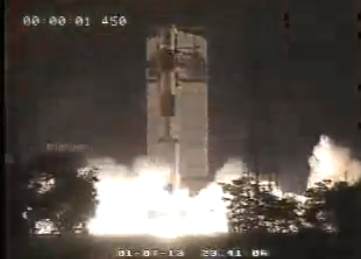
The first satellite of the Indian Regional Navigation Satellite System (IRNSS) was successfully launched today.
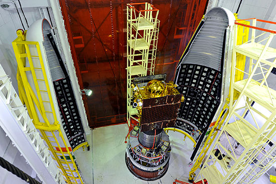
The launch of IRNSS-1A occurred on schedule at is scheduled for 18:13 UTC from the spaceport of Sriharikota. Liftoff from the first launch pad at the Satish Dhawan Space Centre occurred on schedule at 18:11 UTC. The 1,425-kg satellite was launched by the XL version of India’s rocket PSLV-C22, or Polar Satellite Launch Vehicle.
Solar panel deployment was confirmed and the satellite has power and is operating nominally according to reports.
The IRNSS-1A satellite is the first of seven that will make up the IRNSS. The constellation will consist of four satellites in geosynchronous orbits inclined at 29 degrees, with three more in geostationary orbit. IRNSS-1A is one of the geosynchronous satellites, and is expected to be positioned at a longitude of 55 degrees east.
Launch of the first satellite for the Indian Regional Navigation Satellite System (IRNSS) is scheduled for 18:13 UTC on July 1. Launch rehearsal has been completed successfully. The 64-hour countdown is expected to start at 7:11 (IST) tomorrow, June 29, and the launch will take place from the spaceport of Sriharikota. The 1,425 kg satellite will be launched by the XL version of India’s rocket PSLV-C22.
The Indian Space Research Organization (ISRO) Navigation Centre, an important element of the Indian Regional Navigation Satellite System (IRNSS), was inaugurated May 28. The INC has been established at the Indian Deep Space Network complex at Byalalu, about 40 kilometers from Bangalore, India.
IRNSS, an independent navigation satellite system being developed by India, will have a constellation of seven satellites that enables its users to determine their location and time accurately. These satellites will be positioned in geostationary and inclined geosynchronous orbits 36,000 kilometers above the Earth’s surface. IRNSS coverage will extend over India and the southeast Asia region. The satellites are equipped with high-precision atomic clocks and continuously transmit navigation signals to users.
As the focal point of many critical operations of IRNSS, the ISRO Navigation Centre (INC) is responsible for providing the time reference, generation of navigation messages, and monitoring and control of ground facilities including ranging stations of IRNSS. It hosts several key technical facilities for supporting various navigation functions.
Key to the navigation support is the time reference to which all ground systems and the satellite clocks are synchronized. This time reference is generated by the high-precision timing facility located at INC. This timing facility is equipped with high-stability, high-precision atomic clocks to provide stable and continuous time reference to the navigation system.
IRNSS will have a network of 21 ranging stations geographically distributed primarily across India. They provide data for the orbit determination of IRNSS satellites and monitoring of the navigation signals. The data from the ranging/monitoring stations is sent to the data processing facility at INC where it is processed to generate the navigation messages. The navigation messages are then transmitted from INC to IRNSS satellites through the spacecraft control facility at Hassan/Bhopal. The data processing and storage facilities at INC enable swift processing of data and support its systematic storage.
INC is connected to the ranging stations and to the satellite control facilities through two highly reliable dedicated communication networks consisting of satellite and terrestrial links. The hub for the satellite communication links is hosted at INC.
The INC was inaugurated by V. Narayanasamy, minister of state in the Indian prime minister’s office. Speaking on the occasion, Narayanasamy said he appreciated the commitment and dedication of Indian space scientists in realizing the objectives of the country’s space programme. The minister also gave away various awards instituted by Astronautical Society of India (ASI) and ISRO.
Experts ensuring that aircraft can safely rely on satellite navigation across Europe and other parts of the globe met last week to share future plans, welcoming Russian and Indian representatives for the first time, reports the European Space Agency. More and more aircraft around the globe are using satnav augmentation, with special infrastructure sharpening signal accuracy and reliability across given geographical regions.
More than 50 specialists who oversee the world’s five regional satnav augmentation systems met in Toulouse, France, January 24-25 for the latest meeting of the Satellite-Based Augmentation Systems (SBAS) Interoperability Working Group (IWG). The gathering was the first to be attended by Russia’s space agency and the Indian Bureau of Civil Aviation, to discuss their own SBAS systems.
The meeting was jointly hosted by ESA’s European Geostationary Navigation Overlay System (EGNOS) and SBAS Division with the French space agency, CNES.
Satellite augmentation systems provide ground monitoring stations and satellite transponders to sharpen satnav accuracy and reliability across geographical regions. The resulting accuracy improvements, together with information on integrity, renders satnav suitable for the vertical (as well as horizontal) guidance of aircraft and a range of other precision applications.
Today, there are three certified SBAS operational worldwide: Europe has EGNOS, designed and developed by ESA, operated by the European Satellite Service Provider and owned by the European Commission. EGNOS was made available for general users in 2009 and for aircraft landing approaches since March 2011.
The U.S. has the Wide Area Augmentation System (WAAS), developed and operated by the Federal Aviation Administration (FAA), with an extension over Canada called CWAAS (Canadian WAAS). Japan has the Multi-functional Satellite Augmentation System (MSAS), developed and operated by Japan’s Civil Aviation Bureau.
Two more systems are being developed for future certification by the International Civil Aviation Authority: Russia’s System of Differential Correction and Monitoring (SDCM), under development by Roscosmos, and India’s GPS and Geo-Augmented Navigation (GAGAN) system, under development by Indian Civil Aviation and India’s ISRO space agency.
Representatives of these five systems were joined at this 24th IWG meeting by international organisations including Eurocontrol, the European Organisation for the Safety of Air Navigation. Current combined SBAS coverage.
JAVAD GNSS has commented on some news that its receivers can track a new L5 signal from the Indian SBAS satellite, GSAT-8, launched on May 20. In a further explanation to GPS World, CEO Javad Ashjaee explained, “All owners of our products can track it. The only thing is that if customers have not updated their firmware for a long time, they should update to recent firmwares released earlier. They need to update their firmware, which is free of charge and is posted on our website. All of our customers with recent firmware versions can track the GAGAN L5 signal.”
An earlier report from CANSPACE that appeared on the GPS World website said, in part, “Although GSAT-8 reportedly carries a dual-frequency transponder, no L5 signals from this satellite have yet been detected by International GNSS Service tracking stations.”
The JAVAD GNSS statement on September 30 said “Report of GPS World that GAGAN PRN127 does not transmit L5 signal is not correct. Our receivers track it. This graph shows code-phase measurements for this signal.” The web page displays this figure:
A check with a University of Bern, Switzerland, report of stations participating in the IGS M-GEX campaign on October 2 found that a number of stations are tracking the L1 signal from GSAT-8 but none are tracking the L5 signal yet due to issues with receiver firmware. However, various stations in the Cooperative Network for GNSS Observation (formerly the Cooperative Network for GIOVE Observation, still abbreviated CONGO), using Javad Triumph receivers, have tracked GAGAN L1 and L5 signals for more than half a year. No detailed analysis of these measurements has been performed so far.