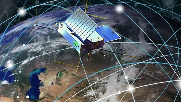
The system is designed to degrade an adversary’s satellite signal acquisition and tracking capabilities
The Indian Ministry of Defense (MoD) has signed a ₹449-crore contract with Bengaluru-based Accord Software and Systems Private Limited (ASSPL) for the procurement of 20 enhanced capability GNSS (ECGNSS) jammers for the Indian Navy.
The system’s capabilities include degrading the satellite signal acquisition and tracking performance of the adversary GNSS receiver and signal spoofing or deceptive jamming, paving the way for safe operations by the Indian Navy in a multi-threat environment.
The deal has been signed under the Buy (Indian-Indigenously Designed, Developed and Manufactured) category and includes a minimum of 75 percent indigenous content.
A ceiling fan slowly churned, stirring the hot, humid air. Outside, warm rains pelted the muddy streets as distant langurs whooped in the thick jungle mists below.
An incessant fly caught the attention of the office’s lone occupant, hunched over a table covered with a large grid-lined sheet of paper. Pencils, erasers, French curves and straightedges lay scattered next to a stack of calculation sheets, but the man holding a pencil in one hand gripped a rolled newspaper in the other, intent on his battle with the fly.
Suddenly, the door burst open.
“Mr. Waugh!” the intruder exclaimed, panting as he rushed in.
“Radhanath,” Waugh replied in surprise, looking up from his maps. “I thought you were in Calcutta, 1,600 km away.”
“Yes, Mr. Waugh, I was, but this is too important to deliver by post.”
“Really, Radhanath. You intrigue me,” replied Waugh. “Come out with it. Your excitement is adding to this already unbearable heat.”
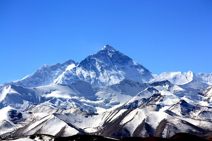
“Sir,” Radhanath tried to say calmly. “I have discovered the highest mountain in the world!”
That conversation happened in 1852. It was the crown jewel of an effort that began 50 years earlier. Britain was on the ascent. Surveying was the mathematics of empire. India, Britain’s largest protectorate, had never been systematically mapped. The British East India Company needed to know what minerals, crops and commodities could be turned into profitable enterprises, where they were, and how to move them to ports. This depended on accurately mapping India. Infantry officer William Lambton proposed an audacious solution: measure the entire subcontinent with triangles.
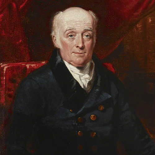
William Lambton
Lambton was granted the commission, and on April 10, 1802, the Great Trigonometrical Survey (GTS) of India began with a humble but critical baseline from St. Thomas Mount near Madras, 12 km south to Perumbauk Hill. Everything depended on the accuracy of this first baseline: even the smallest error would multiply as triangles spread across the subcontinent. Perfection was essential. The distance was measured with a 100-ft steel chain protected from the sun beneath A-frame tents to prevent thermal expansion. It moved slowly, 100 ft at a time from start to finish. Every link mattered. The baseline took 57 days.
To guarantee perfect alignment, Lambton relied on a massive custom-built theodolite. It weighed 1,102 lbs, requiring 12 men to carry. Surveyors planted stakes, stretched strings, and used the theodolite to correct for every change in elevation, turning a simple chain measurement into the geodetic foundation of the entire survey.
Time marched on faster than the survey. The East India Company estimated five years, but by 1818, the survey reached west to Mangalore and north to Hinganghat. It was too slow. Lambton’s vision of “an uninterrupted series of triangles…from sea to sea…to an unlimited extent in every other direction,” a complete geometric quilt covering India, proved implausible. Malaria took its toll. Lambton’s health declined and in 1823 he died at Hinganghat. George Everest inherited the survey.
The map of triangles covered Madras to Mangalore.George Everest
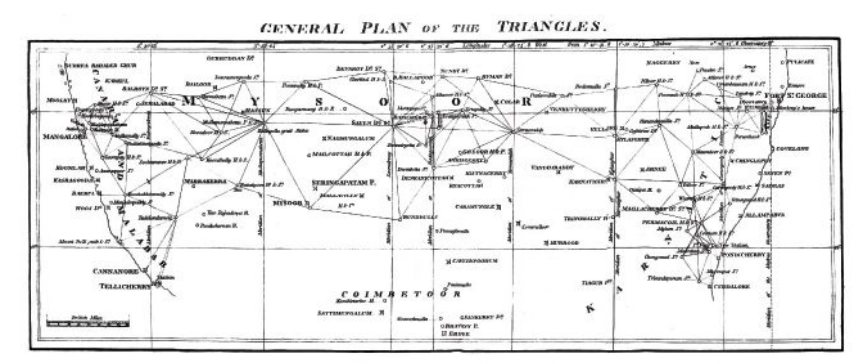
Everest recognized Lambton’s dream of total coverage would take centuries. Instead, he conceived a “gridiron” of chains running north–south and east–west, intersecting at right angles, scaffolding to which localized surveys could be tied. The shift is evident on the GTS map: dense triangulation in south-central India reflects Lambton’s ambition, while the more open, structural network elsewhere reveals Everest’s pragmatism.
By the 1830s, Everest’s survey party had grown into slow-moving caravans, reaching as many as 1,000 people at peak times. Contemporary accounts describe columns supported by elephants, horses and camels, with hundreds of porters carrying tents, instruments and provisions. The logistics were immense: scouts rode ahead to negotiate passage with villages, reapers with scythes gathered grass for the animals, hunters supplied fresh meat and a traveling treasury paid workers and suppliers. To villagers, an approaching column appeared like a military invasion. Negotiations for assistance and safe passage could halt the survey for days.
The survey’s path was relentless. The Great Arc bisected India along the 78th meridian, from Cape Comorin to Bangalore, across the Deccan Plateau, through Hyderabad, over the northern plains to Dehra Dun at the Himalayan foothills. They didn’t simply pass through. They stayed. Sometimes for weeks, building 50 ft masonry towers to mount the theodolites.
When daytime heat and haze made measurements impossible, Everest shifted to night surveying using powerful lanterns visible from 30 miles away. They constantly adapted due to temperature, atmospheric refraction, verification baselines measured at the chain ends. Every measurement propagated from that first line at Madras; a minor error would compound over thousands of miles.
The price was paid in lives. Malaria wiped out entire parties. Three officers died in the Terai, the malarial lowlands of northern India. Two more retired, health-shattered. Everest himself contracted malaria repeatedly, suffering partial paralysis. The climate, he wrote, was “very deadly.”
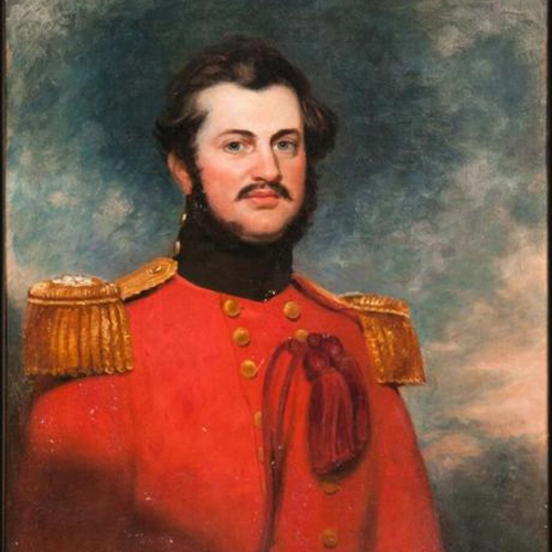
Andrew Waugh
The survey transformed the land. To achieve clear sight lines, villages were razed, sacred hills appropriated, and community supplies exhausted. Yet the work continued. In December 1841, almost 40 years since the GTS began, the 1,500-mile Great Arc was complete. The spine was in place. Everest retired in 1843, passing the work to Andrew Scott Waugh, who extended the gridiron eastward. Nepal and Tibet were closed to outsiders. Waugh understood the distant Himalayan peaks, more than a hundred miles away, would have to be measured from the border stations anchored to the GTS framework. Accuracy became even more critical. This shift in focus from Everest’s large sprawling triangles inching north like a spider’s web forming the Great Arc, to Waugh’s tight triangles hugging the Himalayan frontier is visible on the GTS map.
Over the next decade, Waugh’s teams pushed eastward through the jungles of Bengal, Bihar and Orissa, verifying baselines, fixing latitudes and longitudes astronomically, establishing stations that brought the peaks within mathematical reach. Along the entire border, surveyors recorded the peaks.
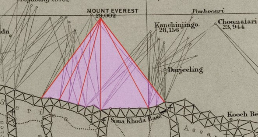
Close-up of the border survey stations used to observe Peak XV. (Credit: Royal Geographical Society)
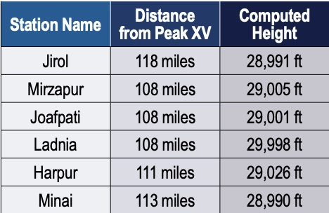
To measure Peak XV, six observation stations were selected across the Terai, the deadly malarial lowlands chosen for the clear site lines to the summit. From these stations, surveyors recorded azimuth and elevation angles across multiple seasons. They measured the summit at sunrise, when the peak was first illuminated. None of the surveyors knew the height of the mountains they were observing because distance could not be measured directly. Only when all stations were plotted on a map could the peak’s position be fixed and the elevation calculated. This high-level mathematics fell to the human computers in Calcutta, led by Radhanath Sikdar.
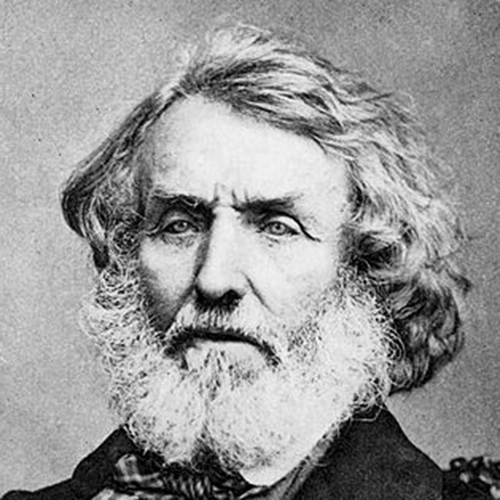
Radhanath Sikdar
By 1851, Sikdar had risen to chief computer, directing the department that transformed field observations into verified measurements. The 1851 Survey Manual acknowledged his distinction: “Babu Radhanath Sickdar, the distinguished head of the Computing Department…whose intimate acquaintance with the rigorous forms and mode of procedure…render his aid particularly valuable.” Yet, neither his education nor his geodetic calculation training prepared him for the complexities of the Himalaya problem. Nonetheless, he took the raw observations and calculated the mountains’ heights to determine which, if any, of the distant peaks was truly the highest point on Earth.
Sikdar calculated the height of each of the peaks. There were many. It was slow, meticulous work. Peak XV required more than standard calculation. Six observation stations produced six independent height measurements, each requiring corrections for atmospheric refraction (light bending through air layers of varying density and temperature), Earth’s curvature (the summit was more than 100 miles away), and plumb-line deviation (the Himalayas’ mass pulled survey instruments slightly toward the mountains).
Sikdar applied the Method of Least Squares, a statistical technique for extracting the most probable value from multiple observations. Each station’s measurement carried uncertainty; combining all six through rigorous mathematics yielded a more reliable result.
The calculation took months. When Sikdar finished, he was stunned: exactly 29,000 ft recalculated and received the same result. The precision seemed too perfect. Sikdar knew the stakes. This wasn’t just another mountain. His calculations were correct. Peak XV was the highest point in the world, Chomolungma, meaning the goddess mother of the Earth. Such a discovery demanded the honor of delivering the news in person.
In April 1852, Sikdar traveled 1,600 km from Calcutta to Dehra Dun. The journey took weeks. He carried the calculations in his satchel and the announcement in his mind.
When Sikdar burst into Waugh’s office with the news, Waugh worried that exactly 29,000 ft (8,830 m) would make surveyors appear to have simply rounded. 2 ft were added, a small fiction to preserve credibility. The official height for Peak XV became 29,002 ft.
Waugh spent four years verifying before the official announcement in March 1856. The mathematics were sound from the moment Sikdar burst into that office. Then, 20 years later, the 1875 Survey Manual erased Sikdar’s name entirely. The British press called it “robbery of the dead.”
Sikdar’s calculations have stood the test of time. The 1954 Survey of India measurement, 102 years later, yielded 29,028 ft, a minimal difference. In 1999, GPS technology placed a receiver on Everest’s summit for the first time: 29,035 ft. The 2015 earthquake prompted the most comprehensive measurement yet.
On May 22, 2019, at 3 a.m., Nepali surveyor Khimlal Gautam departed Everest’s South Col for the 10-hour climb carrying 90 lbs (41kg) of equipment. The pre-dawn timing avoided crowds: the weight included a Trimble R10 GNSS receiver and ground-penetrating radar to distinguish rock height from snow depth. Eight continuously operating reference stations (CORS) were positioned across Nepal to receive signals from GPS, GLONASS, Galileo and BeiDou. Chinese surveyors simultaneously measured from the north.
Gautam spent hours on the summit, collecting data while his body slowly consumed itself in the death zone. He lost a toe to frostbite. A team member nearly died from oxygen depletion. Gautam understood, “Mount Everest symbolizes something in Nepal, but it’s not only a Nepal asset, it’s a world asset.”
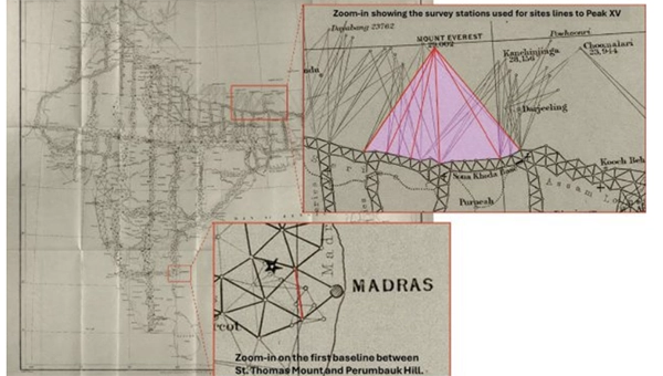
The map of the Great Trigonometrical Survey. (Credit: Survey of India, via David Rumsey Collection)
On Dec. 8, 2020, Nepal and China jointly announced their result, agreeing for the first time the height was 29,031.69 ft. Sikdar’s error across 168 years was 31.69 ft, an accuracy of 0.11%.
From that moment in Dehra Dun, Sikdar, dusty from the road, calculations in hand, certainty in his voice, we trace backward through 50 years of framework building to understand what made that measurement possible. Peak XV, hidden in plain view, seen for hundreds of miles, refusing to be known, was finally measured.
Once we have measured it, we want to believe we know it, but the Indian and Eurasian tectonic plates continue to collide, pushing the mountain up four millimeters per year. Earthquakes in the region change the topography. The geoid problem persists: What does “sea level” mean 440 miles from the coast in a gravitationally dense region? Modern surveyors still grapple with the fundamental question: What does “height” mean when measured against a theoretical reference surface?
The Great Trigonometric Survey proved that surveyors could measure what they couldn’t touch, calculate what they couldn’t reach, and verify what they couldn’t see. It required building the geodetic infrastructure across a subcontinent, maintaining mathematical precision across decades, and accepting brutal human costs.
Then, the computer was a man. The information was in his satchel. The message was delivered in person. It was the first time the height of the highest known point was determined not by a physical barometer on a summit, but by mathematics alone, a man solving equations in a room 440 miles away. Sikdar proved the impossible: What couldn’t be touched could be measured, what couldn’t be reached could be calculated, and a man dusty from the road could hold the height of the world in the palm of his hand.
Four names for one mountain. Each represents a different understanding. Its ancient name, Chomolungma, and Sagarmatha, its national identity. Peak XV, its cartographic name marking the audacious attempt to measure it, and the name Mount Everest, the crowning achievement, a proclamation honoring mathematics, from Hipparchus who is credited with developing trigonometry to the computers, like Sikdar. It stands as a monument to all the surveying and cartography, especially of the 19th century accomplishing the impossible against extraordinary odds.
Surveying and mapping are jobs of courage and determination exploring the unknown, risking death in malaria-infested jungles, Everest working while stricken with partial paralysis, Abdul Hamid crossing a forbidden border, and Gautam’s predawn climb. They all understood what mattered was worth the risk. It is the surveyor’s call to arms: measure the Earth.
The Indian government has approved development of an indigenous, runway-independent combat search-and-rescue UAV for the Indian Air Force.
The drone will be used to rescue pilots and crew, and deliver supplies in extreme terrains, tasks to be accomplished without risking manned aircraft. For instance, snowbound heights are difficult for helicopters to traverse.
The UAV will be developed under the government’s Make-I category with 70% funding, and will operate up to 16,000 feet in the air. It will carry payloads up to 400 kg and support autonomous missions within a range of 200 km and a 45-minute loiter time.
Genesys has developed India’s first large-scale high-definition maps engineered specifically for vehicles enabled with advanced driver assistance systems (ADAS).
Covering more than 1 lakh km of India’s national highways, expressways and strategic corridors, this initiative marks one of India’s most ambitious road intelligence programs and establishes a new benchmark for automotive-grade precision.
India’s highways account for a disproportionately high share of road fatalities, driven by fast-moving traffic, inconsistent lane discipline, and limited real-time awareness for drivers and vehicles. HD maps narrow this gap by adding the centimeter-level context that traditional maps cannot provide — lane geometry, curves, slopes, signage, barriers and localization cues that help ADAS systems anticipate danger instead of merely reacting to it. This is a big leap forward from current sensor-based ADAS systems, Genesys said.
The HD maps include ADAS-critical features such as lane geometry, road markings, barriers, signage, medians, elevation and curvature profiles, and localization objects like poles and gantries — all processed to achieve centimeter-grade precision.
CORS network plays a key role
To achieve the centimeter-level accuracy required for ADAS Level 2 functionality, Genesys relies on the Survey of India’s Continuously Operating Reference Stations (CORS) network. Real-time GNSS correction signals along major corridors dramatically strengthen field operations, allowing survey teams to capture lane-level and asset-level detail that meets global automotive standards.
This work builds on the existing memorandum of understanding between Genesys and Survey of India, enabling collaboration on digital twin projects, national mapping programs, and high-accuracy geospatial missions.
These datasets are owned by Genesys and can be licensed across industries, creating opportunities in commercial fleet navigation, logistics optimization, mobility platforms, safety analytics and automotive R&D.
The International Air Transport Association (IATA) has called for vigilance following the increasing number of GNSS spoofing and jamming incidents worldwide. The growing interference poses a significant risk to flight navigation and pilot safety.
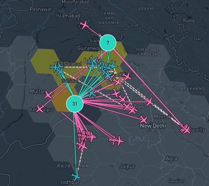
Of note is a spike in incidents at major Indian airports. Almost 2,000 GNSS interference incidents have been logged at airports in India since 2023, including the airports in Delhi, Mumbai, Kolkata, Amritsar, Hyderabad, Bengaluru and Chennai.
IATA represents more than 360 airlines, accounting for 80% of global air traffic. Indian carriers Air India, IndiGo, Air India Express and SpiceJet are members.
“GPS spoofing and jamming incidents are increasing rapidly across the world,” said IATA Director General Willie Walsh, speaking at an industry event in Geneva. “This is not merely a technical concern — it’s an operational vigilance issue for pilots.”
Walsh noted a higher frequency of interference events, expanding well beyond conflict zones and affecting global civil aviation routes.
India’s Civil Aviation Ministry informed Parliament that between November 2023 and November 2025, a total of 1,951 GNSS interference cases were reported. The data collection began after the Directorate General of Civil Aviation (DGCA) issued an advisory circular in November 2023, mandating airlines to report all GNSS-related disruptions.
India’s Directorate General of Civil Aviation (DGCA) has issued an adendum on reporting procedures for suspected GNSS spoofing, reports news service AIN. On Nov. 10, the DGCA began requiring that all spoofing and jamming incidents be reported within 10 minutes, following an intense period of disruptions around Indira Gandhi International Airport in Delhi.
The addendum is meant to clarify exactly what pilots and operators are required to do both before and after a GNSS interference incident is suspected.
The disruptions produced false EGPWS alerts, position errors, and incorrect altitude indications, according to OpsGroup. The interference briefly drove ADS-B integrity in the Delhi terminal area to zero, affecting hundreds of aircraft and leaving controllers unable to rely on GPS-based surveillance.
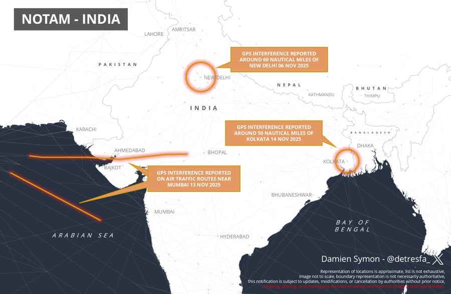
India has issued a Notice to Air Missions (NOTAM) warning of possible GPS interference or signal loss along air traffic routes near Kolkata, reports Business Today.
The NOTAM, valid Nov. 13-17, alerts airlines and pilots to remain vigilant to GNSS disruptions. It follows previous communications sharing issues with GNSS interference in New Delhi and Mumbai. Pilots and air traffic controllers also were asked to report any interference incidents within 10 minutes to the Directorate General of Civil Aviation (DGCA).
After reports of GPS interference in New Delhi & airspace near Mumbai, a new notification from India advises of similar issues now occurring around Kolkata pic.twitter.com/f4N5zd6SVB
India’s Directorate General of Civil Aviation (DGCA) has made it mandatory for pilots and air traffic controllers to report GPS interference within 10 minutes of it occurring, reports Hindustan Times. The new protocol follows incidents at the New Delhi airport reported on Nov. 5.
Incidents that should be reported include position anomalies, navigation errors, loss of GPS integrity, and spoofed location data, states a three-page circular issued on Nov. 10.
The real-time reporting should include data such as aircraft type and registration, airline or operator name, date and time of spoofing occurrence, flight sector and route, coordinates or area of occurrence, type of interference and aircraft equipment affected.
India’s aviation regulator, the Directorate General of Civil Aviation (DGCA), is collecting data on GPS interference and spoofing to have a better understanding of the situation, reports several news outlets in the country. The urge to collect data comes after the Delhi airport experienced issues in the past few days.
Following a circular issued by the Directorate General of Civil Aviation in 2023, instances of GPS interference/spoofing have been reported since November 2023.
Recently, several airlines have faced GPS spoofing at the New Delhi airport, with at least eight such instances on Nov. 5, said an unnamed DGCA official. The interference instances were noticed in domestic and international flights.
Generally, interference issues are reported in border areas, rather than at Indira Gandhi International Airport, the country’s busiest. Daily flight movements have increased to more than 1,500 following an airport terminal upgrade completed in October.
As many as 465 GPS interference and spoofing incidents were reported in the border region, mostly in the Amritsar and Jammu areas, between November 2023 and February 2025.
Disclaimer: A previous version of this article contained an error that has since been removed. We strive for accuracy and transparency, and the current version reflects updates correcting this mistake. Please refer to the information below for more current and accurate details on India’s NavIC satellite constellation.
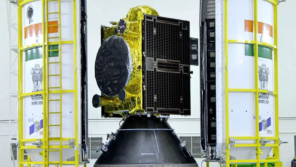
India’s regional satellite navigation system, NavIC (Navigation with Indian Constellation), is facing a severe operational crisis, with only four of its 11 satellites currently operational, according to government data and news reports.
Developed and maintained by the Indian Space Research Organisation (ISRO), NavIC is intended to provide precise positioning, navigation and timing (PNT) services across India and up to 1,500 km beyond its borders. However, this constellation is now on the brink of becoming near-defunct, according to the Indian Defence Research Wing.
Of the four satellites still fully operational, IRNSS-1B has already exceeded its planned 10-year mission life and is at risk of imminent failure. At the same time, IRNSS-1F is also nearing the end of its lifespan with partial equipment failures. IRNSS-1I, launched in 2018, is expected to remain functional until around 2028 but its longevity remains uncertain given the premature failures in the constellation.
The failure of NVS-02 to reach orbit halted progress and highlighted technical challenges that ISRO must address to avoid repeat failures. The Indian government has committed to launching the remaining NVS satellites (NVS-03, NVS-04 and NVS-05) by the end of 2026.
Timely replacement and system upgrades are crucial for maintaining India’s strategic autonomy and meeting the growing demands for accurate, independent navigation services in both civilian and defense applications.
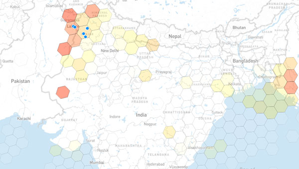
India continues to make significant progress in developing indigenous unmanned aerial vehicles, loitering munitions and autonomous systems. However, many of these platforms face a critical vulnerability: their reliance on unprotected satellite navigation. This threat is no longer theoretical.
Recent escalations with Pakistan, including drone incursions, cyber operations and suspected GPS interference near sensitive border areas, have underscored the growing use of low-cost, easily concealed GNSS jamming tools. Such devices can disrupt UAV operations, sever navigation links and compromise mission success, regardless of how sophisticated the system may be.
Without robust GNSS protection, even the most advanced unmanned systems are at risk of operational failure, loss of control and diminished national security capabilities.
One countermeasure comes from infiniDome, a global provider of GNSS protection technology. The company develops lightweight, easily integrable anti-jamming solutions that are already deployed by leading defense forces to ensure continuous operation in contested electromagnetic environments.
InfiniDome has extensive operational experience in active conflict zones and a strategic focus on compact, cost-effective systems. These solutions are well suited to India’s growing demand for scalable, lightweight UAVs and autonomous platforms, according to the company.
Skykraft, an Australian space technology company, has signed a participating project partner agreement to advance positioning, navigation and timing (PNT) systems in low-Earth orbit (LEO). This agreement, backed by an International Space Investment (ISI) India Projects grant from the Australian Government, marks a significant milestone in fostering space cooperation between Australia and India.
The project’s primary objective is to develop and demonstrate collaborative PNT systems. This includes establishing the viability of large-scale LEO constellations, addressing vulnerabilities in existing GNSS in denied environments, and exploring novel applications for PNT signals from LEO. Additionally, the project aims to create a comprehensive roadmap for collaborative LEO-PNT by implementing resilient, easily updatable constellations.
The project also seeks to enhance environmental monitoring capabilities through GNSS-reflectometry (GNSS-R) and radio occultation (GNSS-RO) technologies. This will improve understanding of Earth’s oceans, droughts, and floods while enhancing real-time space and terrestrial weather forecasting. It will explore emerging applications, such as tsunami monitoring and warning systems.