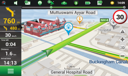
Navitel’s navigation map of India is now available for purchase, for use with the Navitel Navigator GPS & Maps app on Google Play. Navitel Navigator is a precise offline GPS navigation with free geosocial services and detailed maps of 59 countries, with 20 million downloads worldwide.
The map of India contains 2,092,013 km of road graph, 594 627 cities, towns, and other settlements, as well as 5,294,344 POI. Coupled with the address search in more than 6 000 residential and industrial areas of settlements, this map includes the detailed housing system data with due account for the number of floors, detailed road networks with all streets, roads, and indicated traffic direction, road interchanges, roundabouts, and other important road information.
The map contains 149 3D points of interest, including:
Gujarat – ISCON Mall, Satyam Centre, the Metropole Hotel, Kaizen Hospital.
Karnataka – Bangalore Palace, Software Technology Park of India, Jamia Masjid, Hotel Savannah Sarovar Premiere, Jawahar Bal Bhawan park.
TamilNadu – Chennai International Airport, Chennai Railway Station, Manorama Hotel, Lemon Tree Hotel.
Haryana – Vardhman Star Mall, YMCA University of Science and Technology, Mini Secretariat, Sarvodaya Hospital, Gurgaon Centre.
Chandigarh – Panjab University, Chandigarh College of Engineering & Technology, Haryana and Punjab Secretariat, Hotel Royal Plaza.
Details for Map of India, Q1 2015:
2,092,013 km of road graph;
594,627 settlements on the map;
6,614 settlements allowing the address search;
8,217,526 addresses;
149 3D points of interest;
5,294,344
Android OS device users can purchase a license key to the new product at Google Play and from the program menu by selecting “My Navitel” > “Purchase maps”.
The Q1 2015 map of India is compatible only with 9.1.0.0 and later versions of Navitel Navigator.
In the report, the analysts have identified and deciphered the market dynamics in important GNSS industry segments, highlighting the areas offering promising possibilities for companies to boost their growth, according to Research and Markets. The report studies the market by sectors including location-based services (LBS), transportation (further divided into road navigation, rail navigation, air navigation and marine navigation), surveying and agriculture. The GNSS application market is further studied by region: North America, Europe, Asia-Pacific, and Rest of World.
The report provides a complete overview of the GNSS market globally. All the current trends and drivers, coupled with potential growth areas of the GNSS industry, have been evaluated in the report. Furthermore, the report provides information on opportunities in the industry for different companies in the chapter titled Opportunity Assessment.
Additionally, to provide an exhaustive knowledge of the prospects for GNSS players on the geographical front, the report provides comprehensive knowledge of the 10 most worthwhile GNSS markets around the world (U.S., Canada, UK, France, Germany, Russia, Japan, China, South Korea and India). It includes information about the present state and future outlook of the LBS and telematics markets in these countries along with information about their personal navigation systems such as GPS, BeiDou,Galileo, GLONASS, QZSS and IRNSS.
The report also looks into the competitive landscape covering business overviews, key financials, product analyses, recent developments and strengths and weaknesses of each of the players.
Key trends considered in the report include:
Driverless Car: New GNSS Technology Use
Indoor GNSS Positioning Poised for Growth
People, Pets and Thing Finder: The Next Attraction
GNSS Based Products: A Burgeoning Market Opportunity
The launch of the fourth satellite for the Indian Regional Navigation Satellite System, previously scheduled for March 9, has been postponed until March 29 at 13:00 UTC. The delay is due to the replacement of a faulty telemetry transmitter on the satellite.
“We are targeting the last few days of March for the launch. A team is working on a new telemetry transmitter to replace the [faulty] one that failed in the satellite. After fixing it, all numerous tests that we conducted earlier must be repeated,” M.Y.S. Prasad, Director of the launch unit, Satish Dhawan Space Centre, Sriharikota, told The Hindu on Tuesday.
The launch, originally scheduled for March 9, was delayed March 4 when routine checks found a transmitter malfunctioning. The ISRO delayed the flight and removed the satellite from its launcher to put a new transmitter.
IRNSS-1D will be fourth in the seven-spacecraft IRNSS constellation.
— With information provided by the CANSPACE listserv.
During the integrated electrical checks on March 3 of the launch vehicle and satellite following closure of the heat shield, an anomaly was observed in one of the telemetry transmitters of the satellite, according to a post on the Indian Space Research Organization (ISRO)’s Facebook page.
“In order to resolve the technical anomaly through further test, simulation and analysis, the launch of PSLV-C27 with IRNSS-1D has been postponed,” the post states. IRNSS-1D will be flown into space in the Indian Polar Satellite Launch Vehicle-XL (PSLV-C27) from Satish Dhawan Space Centre, Sriharikota.
IRNSS-1D is the fourth navigation satellite in the Indian Regional Navigational Satellite System, and will make the constellation operable.
The Indian Space Research Organization (ISRO) is expected to launch IRNSS-1D on March 9, reports The Times of India. IRNSS-1D is the fourth navigation satellite in the Indian Regional Navigational Satellite System, and will make the constellation operable.
The launch is tentatively planned for March 9 around 6:35 p.m. However, final go for the launch will be given by the ISRO’s Launch Authorization Board, which will meet March 6.
IRNSS-1D will be flown into space in the Indian Polar Satellite Launch Vehicle-XL.
The space segment of the IRNSS consists of seven satellites: three in geostationary orbit and four in inclined geosynchronous orbit. The ground segment consists of infrastructure for controlling, tracking and other facilities. The entire IRNSS constellation of seven satellites is planned to be completed by 2015.
Both IRNSS-1A and 1B are functioning satisfactorily from their designated geosynchronous orbital positions. The first three satellites in the IRNSS series were launched from Sriharikota on July 1, 2013, April 4, 2014, and October 16, 2014. IRNSS-1E and IRNSS-1F satellites are expected to be launched before year end.
IRNSS is an independent regional navigation satellite system designed to provide position information in the Indian region and 1,500 kilometers around the Indian mainland. IRNSS will provide two types of service: Standard Positioning Services (SPS) — provided to all users — and Restricted Services (RS), provided to authorized users.
India-based GNSS device maker Stesalit has introduced a SXgeoCloud mobile mapping application. SXgeoCloud provides a full GIS data collection suite with active sync to leading enterprise GIS systems through a mobile and cloud architecture. SXgeoCloud will be available with the Sxtreo series of GPS/GNSS devices from Stesalit and is now available only to customers in India.
SXgeoCloud is compatible with all the SXtreo rugged GNSS field computers and other field GNSS devices. SXgeo is the offline mobile GIS software suite from Stesalit.
The Android-based mobile mapping system of SXgeoCloud supports over 50 OGC compliant formats and background raster Web Mapping Services. It allows users to acquire geospatial data including points, lines and polygons, along with their attributes with the advantage of creating new objects in the field. It supports all editing features and is flexible for users to work on offline and online basis with active sync to the SXgeoClould Server.
The cloud server of SXgeoCloud combines project creation, data-collection management, active sync, and archival. Data sets acquired or new objects created in the field are automatically updated in the cloud GIS server in real time, and can be actively synced with the user’s enterprise GIS in real time. Users can customize the data-capture properties, attributes, and forms to match their own enterprise database requirements. With SXgeoCloud, integration with industry-leading GIS server systems is seamless.
SXgeoCloud ensures consistently high-quality data import and export in a variety of GIS and CAD formats, increasing field work efficiency, productivity and the accuracy of GNSS data.
The root cause of the anomaly that sent two Galileo satellites into the wrong orbit on August 22 was a shortcoming in the system thermal analysis performed during stage design, and not an operator error during stage assembly, according to findings by an independent inquiry board.
The independent inquiry board was created by Arianespace, in conjunction with the European Space Agency and the European Commission. Its conclusions draw on data supplied by Russian partners in the program, and are consistent with the final conclusions of the inquiry board appointed by the Russian space agency Roscosmos.
The anomaly occurred during the flight of the launcher’s fourth stage, Fregat, designed and produced by NPO Lavochkin. It occurred about 35 minutes after liftoff, at the beginning of the ballistic phase preceding the second ignition of this stage.
The board’s conclusions confirm that the first part of the mission proceeded nominally, which means that the three-stage Soyuz launcher was not at fault. The inquiry board also eliminated the hypothesis that the anomaly could have been caused by the abnormal behavior of the Galileo satellites.
The scenario that led to an anomaly in the orbital injection of the satellites was precisely reconstructed, as follows:
The orbital error resulted from an error in the thrust orientation of the main engine on the Fregat stage during its second powered phase.
This orientation error was the result of the loss of inertial reference for the stage.
This loss occurred when the stage’s inertial system operated outside its authorized operating envelope, an excursion that was caused by the failure of two of Fregat’s attitude-control thrusters during the preceding ballistic phase.
This failure was due to a temporary interruption of the joint hydrazine propellant supply to these thrusters. The interruption in the flow was caused by freezing of the hydrazine.
The freezing resulted from the proximity of hydrazine and cold helium feed lines, these lines being connected by the same support structure, which acted as a thermal bridge.
Ambiguities in the design documents allowed the installation of this type of thermal “bridge” between the two lines. In fact, such bridges have also been seen on other Fregat stages now under production at NPO Lavochkin.
The design ambiguity is the result of not taking into account the relevant thermal transfers during the thermal analyses of the stage system design.
The system thermal analyses have been reexamined in depth to identify all areas concerned by this issue. The board has chosen these corrective actions for the return to flight.
Revamp of the system thermal analysis.
Associated corrections in the design documents.
Modification of the documents for the manufacture, assembly, integration, and inspection procedures of the supply lines.
Arianespace said these measures can immediately be applied by NPO Lavochkin to the stages already produced, meaning that the Soyuz launcher could be available for its next mission from the Guiana Space Center in December.
“We are looking at the resumption of Soyuz launches from the Guiana Space Center, as early as December 2014,” stated the Arianespace CEO. “The resolution of this anomaly will enable a consolidation of the reliability of Fregat, which had experienced 45 consecutive successes until this mission.”
Galileo Service Controls Handed to GNSS Agency
Full Operability Set for 2020
The European GNSS Agency (GSA) and the European Commission have concluded an agreement that delegates a range of exploitation tasks for Galileo to the GSA, providing a framework and budget for the development of services and operations through 2021.
The signing of the Galileo Exploitation Delegation Agreement serves as an initial step towards the full Galileo Exploitation Phase. According to the governance structure set out in the agreement, the European Commission is responsible for the overall programme supervision, the European Space Agency (ESA) is entrusted with the deployment phase, while the GSA is responsible for the exploitation phase. The GSA’s responsibilities include:
provision and marketing of the services
management, maintenance, continuous improvement, evolution and protection of the space and ground infrastructure
research and development of receiver platforms with innovative features in different application domains
development of future generations of the system
cooperation with other GNSS
all other required activities to ensure the development and smooth running of the system.
“With Galileo, we aim to provide a tangible service to European citizens, and this Delegation Agreement ensures we have the tools and funding necessary to achieve this,” said GSA Executive Director Carlo des Dorides.
Full operability of Galileo is now scheduled for 2020, a slight revision of the previous 2018 projection.
The agreement specifically sets the actions to be implemented, the amount of funding provided, and the conditions for the overall management. The maximum current EU contribution amounts to EUR 490 million, which will cover procurement and grant activities, including the GSA-ESA working arrangements and a programme management reserve, along with related research and development activities. The financing of the full exploitation phase will be confirmed during a mid-term review before the end of 2016.
India Launches Third Satellite and ICD
India successfully launched IRNSS-1C, the third satellite in the Indian Regional Navigation Satellite System (IRNSS), on October 16. The satellite was injected to an elliptical orbit of 282.56 x 20,670 kilometers, very close to its intended final geostationary orbit at 83 degrees East longitude.
IRNSS-1C is the third of the seven satellites constituting the space segment of the Indian Regional Navigation Satellite System. Tthe first two were launched in July 2013 and April of this year. Both are functioning satisfactorily from their designated geosynchronous orbital positions.
IRNSS is an independent regional navigation satellite system designed to provide position information in the Indian region and 1,500 kilometers around the Indian mainland. IRNSS will provide two types of services: Standard Positioning Services (SPS), provided to all users, and Restricted Services (RS), provided to authorized users. Ground stations have been established in at least 15 locations across India.
The next satellite of the constellation, IRNSS-1D, is scheduled to be launched in the coming months. The full IRNSS constellation of seven satellites is planned to be completed by 2015.
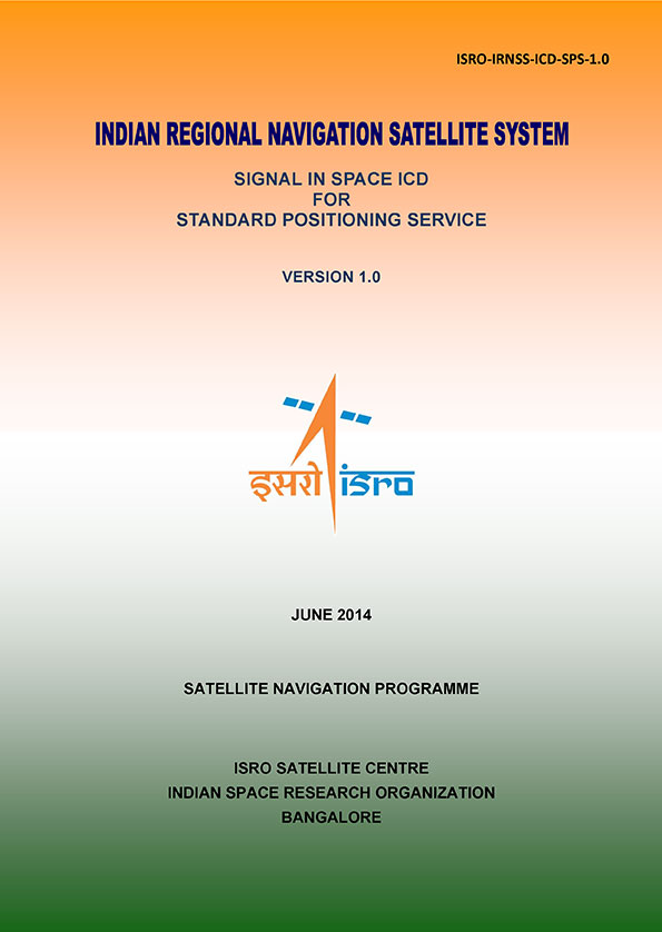
IRNSS ICD Released. In late September, the Indian Space Research Organization (ISRO) released version 1 of the IRNSS Signal in Space Interface Control Document (ICD) for the Standard Positioning Service.
The document provides information on the signals and structures of the IRNSS system, including signal modulations, frequency bands, received power levels, the data structures and their interpretations, and user algorithms.
Registration is required for ICD download access at a new IRNSS website.
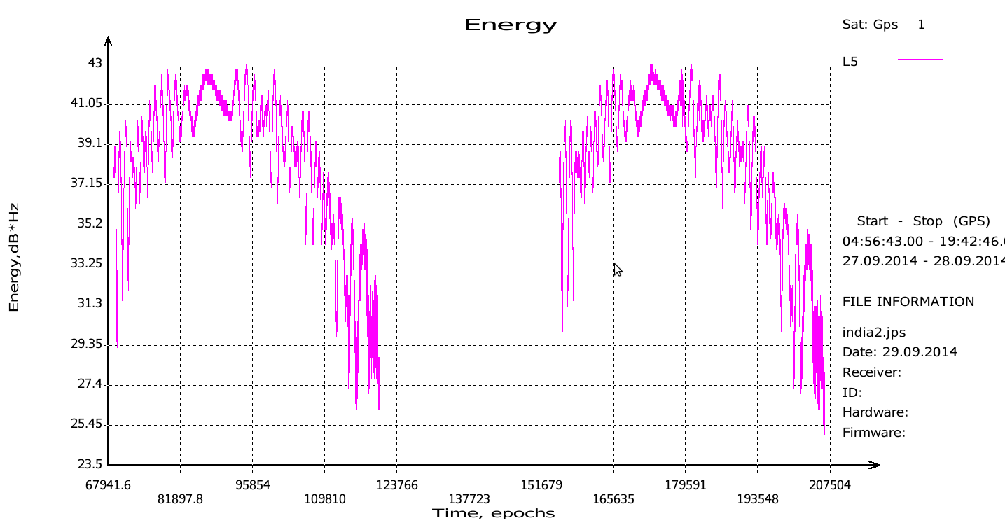
JAVAD Tracks Signal. JAVAD GNSS published a chart showing that it has tracked the IRNSS L5 signal.
Shortly after ISRO released its IRNSS Signal in Space Interface Control Document (ICD), JAVAD GNSS tracked the L5 BPSK signal from both 1A and 1B satellites. Ability to track IRNSS L5 will be added to all JAVAD L5-capable receivers in the near future, the company said.
SNR of two passes of 1A satellite (IGSO) over Moscow.
Let’s All Be GPS III for Halloween
As this magazine goes to press on October 23, the U.S. Air Force is set to launch the eighth GPS IIF satellite from Cape Canaveral Air Force Station on Wednesday, October 29. An 18-minute launch window will open at 1:21 p.m. U.S. Eastern time. If all goes well, the satellite will be accomplishing its early-orbit checkouts and beginning maneuvers towards its final orbital plane as U.S. children make their costumed Halloween rounds, collecting candy. Other Western countries celebrate All Hallows’ Eve followed by All Saints’ Day on November 1.
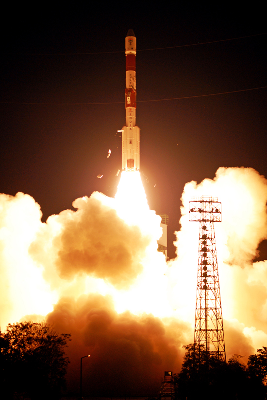
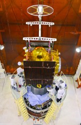
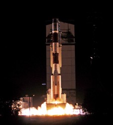
The third IRNSS satellite heads into orbit. Photo: ISRO
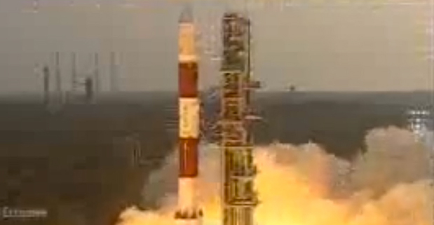
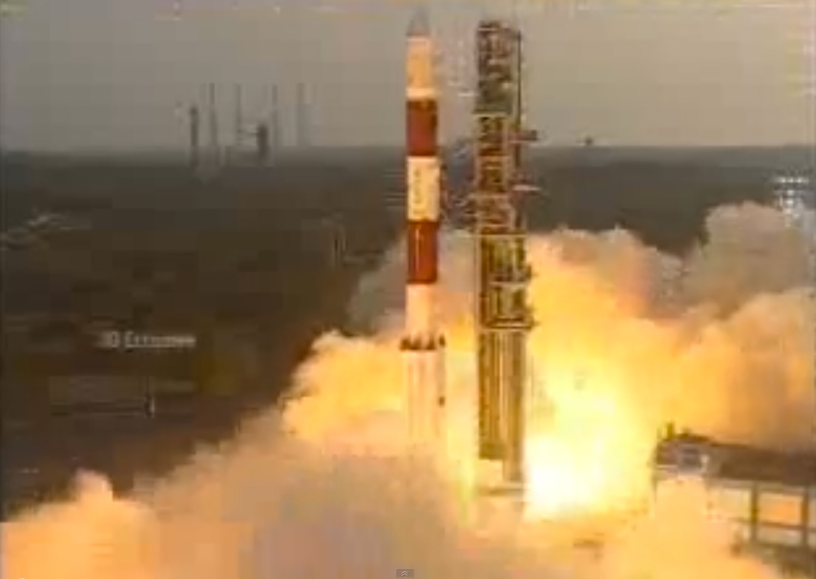
India has successfully launched IRNSS-1C, the third satellite in the Indian Regional Navigation Satellite System (IRNSS), early on October 16. The satellite was launched aboard the Polar Satellite Launch Vehicle (PSLV) C26 at 2002 GMT (4:02 p.m. EDT) from Satish Dhawan Space Centre, Sriharikota.
After the lift-off of PSLV-C26 with the ignition of the first stage, the important flight events — namely, stage and strap-on ignitions, heat-shield separation, stage and strap-on separations and satellite injection — took place as planned, according to the Indian Space Research Organization (ISRO). After a flight of about 20 minutes, 18 seconds, the IRNSS-1C satellite, weighing 1425 kg, was injected to an elliptical orbit of 282.56 km x 20,670 km, which is very close to the intended orbit.
After injection, the solar panels of IRNSS-1C were deployed automatically. ISRO’s Master Control Facility (at Hassan, Karnataka) assumed the control of the satellite. In the coming days, four orbit maneuvers will be conducted from the Master Control Facility to position the satellite in the geostationary orbit at 83 degrees East longitude.
IRNSS-1C is the third of the seven satellites constituting the space segment of the Indian Regional Navigation Satellite System. IRNSS-1A and IRNSS-1B, the first two satellites of the constellation, were successfully launched by PSLV on July 02, 2013, and April 04, 2014, respectively. Both IRNSS-1A and 1B are functioning satisfactorily from their designated geosynchronous orbital positions.
IRNSS is an independent regional navigation satellite system designed to provide position information in the Indian region and 1,500 kilometers around the Indian mainland. IRNSS will provide two types of services, namely, Standard Positioning Services (SPS) — provided to all users — and Restricted Services (RS), provided to authorized users.
A number of ground stations responsible for the generation and transmission of navigation parameters, satellite control, satellite ranging and monitoring, etc., have been established in as many as 15 locations across the country.
This is the 27th consecutively successful mission of the PSLV, which used the XL configuration of PSLV for the seventh time. Honorable Minister of State (Space) Jitendra Singh, witnessed the launch from the Mission Control Centre at SDSC, Sriharikota.
The next satellite of this constellation, IRNSS-1D, is scheduled to be launched by PSLV in the coming months. The entire IRNSS constellation of seven satellites is planned to be completed by 2015.
Below is a slideshow with images from the launch preparations and launch.
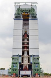
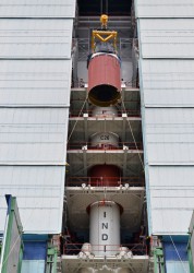
Nozzle end segment of PSLV-C26 being hoisted for assembly. Photo: ISRO
Nozzle end segment of PSLV-C26 being hoisted for assembly with launch pedestal. Photo: ISRO
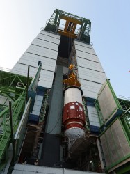
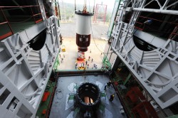
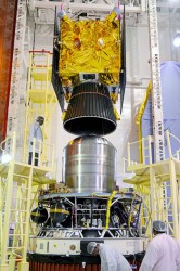
IRNSS-1C being assembled with PSLV-C26 in the mobile service tower. Photo: ISRO
PSLV-C26 inside the mobile service tower prior to satellite integration. Photo: ISRO
IRNSS-1C being assembled with PSLV-C26. Photo: ISRO
The PSLV-C26, carrying IRNSS-1C, lifts off. Photo: ISRO
Assembly of PSLV-C26, third and fourth Stages. Photo: ISRO
The third IRNSS satellite heads into orbit. Photo: ISRO
JAVAD GNSS has published a chart showing that it has tracked the IRNSS (Indian Regional Navigational Satellite System) L5 signal.
Shortly after the Indian Space Research Organization (ISRO) released its IRNSS Signal in Space Interface Control Document (ICD), JAVAD GNSS was able to track the L5 BPSK signal from both 1A and 1B satellites. Ability to track IRNSS L5 will be added to all JAVAD L5-capable receivers in the near future, the company said.
SNR of two passes of 1A satellite (IGSO) over Moscow.
The Indian Space Research Organization (ISRO) has released Version 1 of the Indian Regional Navigational Satellite System (IRNSS) Signal in Space Interface Control Document for the Standard Positioning Service.
The document provides information on the signals and structures of the IRNSS system, including signal modulations, frequency bands, received power levels, the data structures and their interpretations, and user algorithms.
According to ISRO, the document is being released to the public to facilitate research and development and to aid the commercial use of the IRNSS signals for navigation-based applications.
Registration is required for ICD download access at a new IRNSS website. At the moment, only the ICD is available at this website.
The next IRNSS satellite launch is scheduled for the second week of October. The most recent launch was in April, of the second IRNSS satellite, IRNSS-1B.
IRNSS is an independent regional navigation satellite system being developed by India. It is designed to provide accurate position information service to users in India and the region extending up to 1,500 kilometers from its boundary. IRNSS will provide two types of service: Standard Positioning Service (SPS) and Restricted Service (RS). It is expected to provide a position accuracy of better than 20 meters in the primary service area.
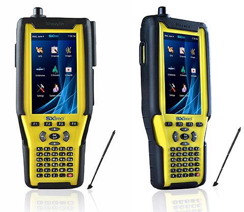
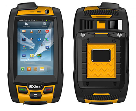
Stesalit today announced the availability of the SXtreo range of rugged GPS handhelds for survey, industrial use, and field work under extreme conditions such as agriculture, forestry, roads, security and construction.
The SXtreo series of mobile devices are rated IP-68, meaning they are waterproof, dust proof, shockproof, and are coupled with built-in mobile GIS applications. Long battery life allows GPS data collection for a full work day, without the need for recharging. The GNSS devices come with full-size USB port for connecting devices.
Stesalit is based in India, and the SXtreo gives that country an affordable option to take geotagged photos and conduct waypoint surveys. The design and conceptualization of SXtreo is a result of the in-house R&D effort of Stesalit. The road towards the birth of SXtreo is presented in the video:
The GAGAN-enabled SXtreo GN series of rugged GNSS field computers and PDAs comes with a full keypad and large five-inch sunlight-readable screen for field data entry in large forms. These models are designed for GPS data collection and asset management, socioeconomic surveys, mapping, agriculture, logistics, forestry, public transportation, construction and security.
The SXtreo WP 60 and WP61 devices have all the features of a smartphone.
The SXtreo WP 61 rugged smartphone.
SXtreo handheld’s Android and embedded Linux-based open-source secured operating systems are compatible with a range of sector-specific applications designed by Stesalit.
SXgeo is specially designed for waypoint, routes, and track surveys. The added advantage from the similar existing applications is that one can capture geotagged photos and transfer the survey data through GPRS.
SXsurvey is a complete suite for comprehensive survey management. With the features of SXgeo, one can also create large forms dynamically in the devices for survey data collection.
SXfield is specifically built for the field workers and employees working away from office like road construction, oil, gas and other utility services, logistics and distribution chains, FMCG, consumer and white good companies with large sales networks, operations and maintenance organizations with large service networks, and security organizations including police.
The integrated application SXagro is a geospatial agriculture decision-support system in use by agriculture universities and state agriculture departments.
In addition, the SXtreo range of IP68 rugged smartphones is compatible with most of the off-the-shelf mobile software applications.
India’s Indian Space Research Organisation (ISRO) launched its second navigation satellite today, April 4, at 11:44 UTC. A Polar Satellite Launch Vehicle (PSLV) rocket launched the IRNSS-1B spacecraft in a mission originating from the Satish Dhawan Space Centre.
Liftoff was on schedule. IRNSS-1B is the second of seven satellites that comprise the first-generation Indian Regional Navigation Satellite System (IRNSS). IRNSS-1B will join IRNSS-1A already in orbit in forming the first pair of satellites for the IRNSS.
Watch the launch in this video:
The IRNSS system will consist of three geostationary satellites and two pairs of spacecraft in inclined geosynchronous orbits. Each IRNSS satellite uses a rubidium-based atomic clock to keep time, transmitting signals on L and S-band frequencies at 1,176.45 and 2492.028 megahertz respectively. A C-band transponder and an array of retroreflectors will be used to determine ranging data for calibration, according to NASASpaceflight.com.