Tag: inertial measurement unit

  • Coloring the map to reduce visual drift in GNSS-denied navigation

    Coloring the map to reduce visual drift in GNSS-denied navigation

    Visual localization is widely used as a low-cost solution for autonomous driving, robotics, and mobile navigation. However, monocular systems remain vulnerable to illumination changes, weak texture, occlusion, motion blur and long-term drift.

    Existing map-based methods can reduce that drift by aligning camera observations with a prebuilt global map, yet many still struggle with redundant computation, weak cross-modal matching between camera images and point clouds, and optimization errors in large-scale or repetitive scenes.

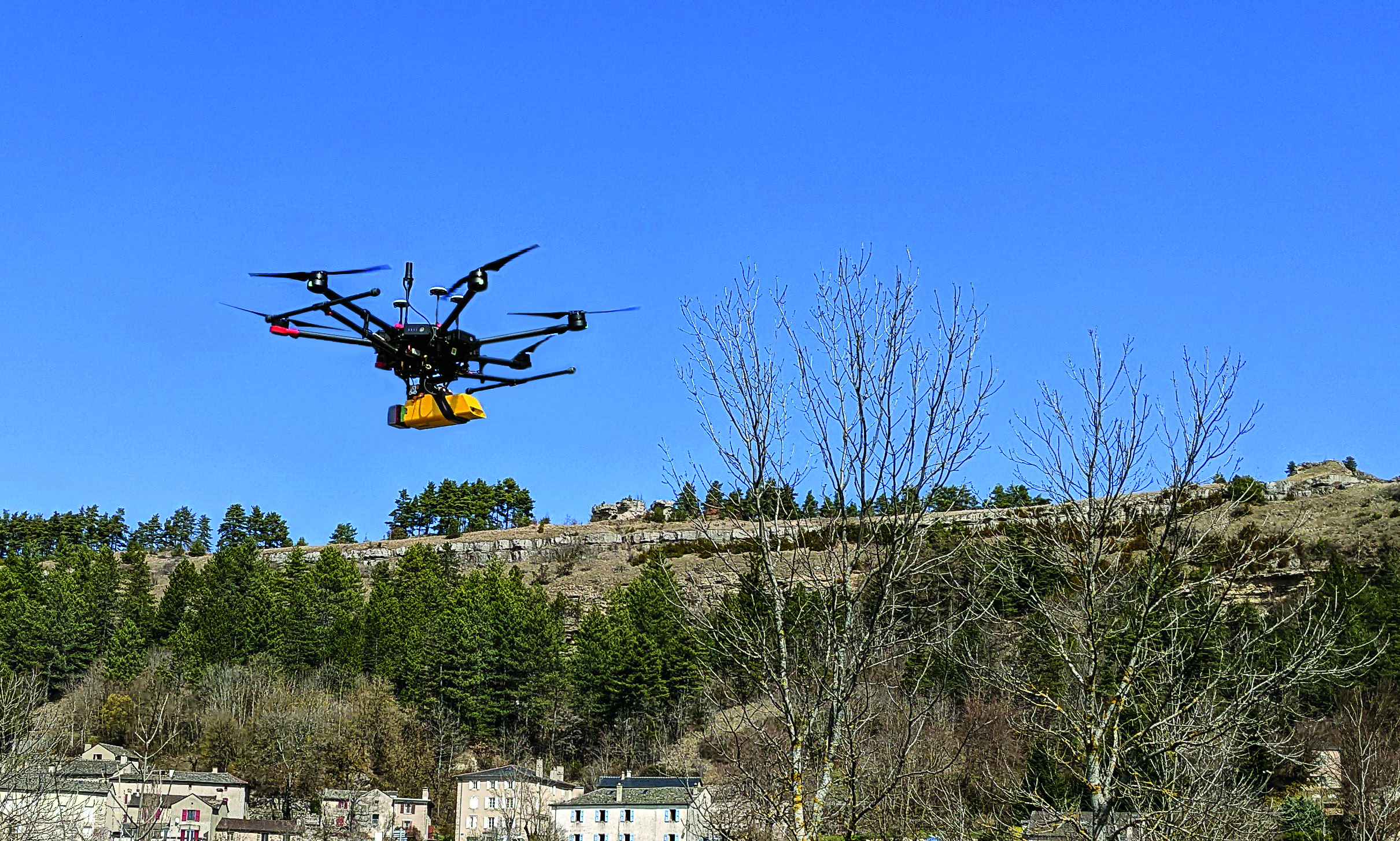
    The challenge is especially important for lightweight platforms that cannot afford onboard lidar, inertial measurement unit (IMU) and heavy computing. Because of these problems, deeper research is needed on camera-only map-based localization that can stay accurate, efficient and stable in complex real-world environments.

    Overview of the proposed camera-only map-based localization framework. (Credit: Satellite Navigation)
    Overview of the proposed camera-only map-based localization framework. (Credit: Satellite Navigation)

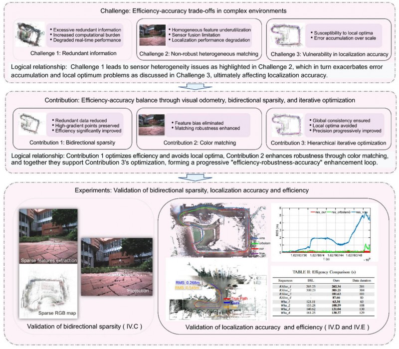
    On April 20, researchers from Wuhan University and Chongqing University reported (DOI: 10.1186/s43020-026-00196-x) in Satellite Navigation a camera-only localization framework that uses prebuilt colored point cloud maps, a dual-sparsity matching strategy that retains high-gradient features in both the map and image observations, and hierarchical geometric–photometric optimization to improve both positioning accuracy and computational efficiency in GNSS-challenged environments.

    The system is built around two connected stages. First, the researchers generate a sparse colored point-cloud map from a denser map produced by lidar–IMU–camera mapping, keeping only high-gradient points that preserve visually salient structures while removing weak or redundant information.

    They apply a similar sparse selection process to online camera images, creating what the team calls “dual-sparsity matching” between map and observation. During localization, the method uses Lucas–Kanade optical flow to track sparse 2D image features and associates them with 3D map points, while hidden-point removal helps retain only the map points actually visible from the current viewpoint.

    The pose is then refined through an iterated error-state Kalman filter in two stages: a geometric PnP-style correction for stable coarse alignment, followed by photometric refinement using image intensity consistency for sub-pixel accuracy.

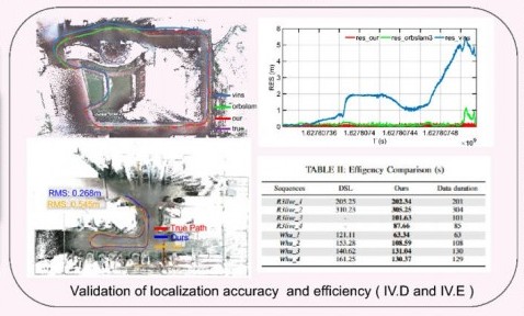
    Tests on the R3live and WHU-Motion datasets showed major gains over existing methods. Compared with direct sparse localization (DSL), the new approach cut absolute trajectory error (ATE) by 52% to 95% across challenging sequences, including a drop from 1.883 m to 0.152 m on R3live_5. It also improved accuracy by up to 76.6% over I2D-Loc++, reduced total processing time by as much as 47.7%, and remained robust in degenerate scenes where geometry-only localization deteriorated to 9.23 m while the proposed tracker held an ATE of 0.076 m.

    Ablation results further showed that colored maps, bidirectional sparsity, and hierarchical optimization each played a distinct role in achieving the final balance of speed, robustness, and precision.

    The authors said the main advance is not simply adding color to a map, but treating the global colored point cloud map as a continuous observation within the visual odometry framework. They said the framework shows that a monocular camera can localize far more robustly when paired with a prebuilt colored point cloud map and a coarse-to-fine optimization design that avoids poor local solutions.

    In their view, the study offers a practical middle ground between fully sensor-rich systems and fragile vision-only pipelines, preserving much of the accuracy benefit of map-based localization without demanding equally heavy hardware on the client platform.

    The work could have immediate value for indoor logistics robots, underground inspection platforms, warehouse vehicles, parking-garage navigation systems, and other low-cost autonomous agents operating where GNSS is weak or unavailable. Because the mapping can be completed offline and reused, the online platform needs only a monocular camera, which lowers sensing requirements while retaining strong global constraints.

    That makes the method especially attractive for scalable deployments in structured but challenging spaces such as tunnels, campuses, hospitals, and industrial facilities. More broadly, the study suggests that future navigation systems may become both lighter and more dependable by making better use of the information already shared between maps and images, rather than relying only on ever-larger sensor stacks.

  • Telit Cinterion adds dual-band L1+L5 GNSS modules for trackers and high-precision IoT

    Telit Cinterion adds dual-band L1+L5 GNSS modules for trackers and high-precision IoT

    Telit Cinterion, an end-to-end IoT solutions enabler, has expaned its GNSS portfolio with two dual-band positioning modules: the ultracompact SE873K5-D and the high-end SE869eK5-DRK

    Built on the AG3335 chipset series from long-time partner Airoha, the new modules support space- and power-constrained internet of things (IoT) devices and use cases that require continuous, ultraprecise positioning. 

    The SE873K5-D and SE869eK5-DRK provide a scalable path to adopt dual-band L1 + L5 GNSS. Device manufacturers can add advanced correction technologies and resilient positioning architectures without redesigning hardware.  

    When combined with Telit Cinterion cellular connectivity solutions, the modules support the injection of RTCM corrections worldwide. This feature enables higher accuracy across connected IoT deployments.

    SE873K5-D
    The SE873K5-D expands the established SE873K5 family with a dual-band L1 + L5 variant. It is designed for size- and power-constrained applications.  

    This new module maintains the same 7 x 7 mm footprint and pin-to-pin compatibility as the single-frequency SE873K5. OEMs can scale performance without changing hardware designs.

    The SE873K5-D supports multiconstellation GNSS across the L1 and L5 bands. Compared to single-frequency solutions, it improves accuracy and robustness against interference and multipath effects.  

    With DGNSS support via RTCM corrections, the module enables submeter accuracy. It is ideal for myriad use cases, from wearables to fleet management.  

    Two power supply variants enable designers to optimize for either minimal size or ultralow power consumption in battery-operated devices. Multiple configurable usage profiles, such as tracking and drone modes, provide added flexibility across IoT verticals.  

    SE869eK5-DRK
    The SE869eK5-DRK is the next evolution of Telit Cinterion’s high-end GNSS offering. Based on the upper tier of the AG3335 chipset family, this module builds on the previously announced SE869eK5-DR. It adds support for RTK positioning with untethered dead reckoning. 

    This powerful combination enables uninterrupted, centimeter-level positioning. It maintains performance even when GNSS signals are degraded or unavailable due to interference or signal blockage.  

    The SE869eK5-DRK has an embedded inertial measurement unit. This feature helps maintain accurate position fixes in environments like tunnels and dense urban areas. The module supports DGNSS for submeter accuracy when RTK corrections are unavailable or when centimeter-level precision is not needed. 

    The SE869eK5-DRK is designed in an industry-standard 16 x 12.2 mm form factor. It introduces a proprietary extended pinout while remaining backward-compatible with existing designs. The added pins enable future-proof implementations and customization. OEMs can expand capabilities over time without redesigning their products.

    Engineering validation testing samples of the SE873K5-D are available now. Design validation testing samples are expected soon. Mass production is planned for Q2 2026.  

    Design validation testing samples for the SE869eK5-DRK are available now. Mass production is planned for Q2 2026.  

    For more information about the SE873K5-D and the SE869eK5-DRK, visit Telit Cinterion at Embedded World at Booth #3-620. The event runs March 10-12 at the Exhibition Centre Nüremberg. 

  • Honeywell introduces HGuide i700 IMU for unmanned air, land and sea

    Honeywell introduces HGuide i700 IMU for unmanned air, land and sea

    Honeywell has launched the HGuide i700, an inertial measurement unit (IMU) that delivers high-accuracy performance for unmanned air, land and sea vehicles. By pairing near navigation-grade capability with a no-license-required (NLR) classification, the HGuide i700 provides integrators worldwide with a powerful new option for critical sensing and navigation.

    The HGuide i700 uses high reliability sensors and electronic architecture found in Honeywell’s HG3900 inertial measurement unit (IMU). Compact and low power, the HGuide i700 delivers near-navigation-grade accuracy and reliability while being optimized to support longer range navigation in GNSS-denied environments

    “As customers explore new autonomous, robotic and precision-guided solutions, they want the accuracy and reliability of inertial systems that can be tailored to their program requirements,” said Matt Picchetti, vice president and general manager, Navigation and Sensors, Honeywell Aerospace. “The HGuide i700 offers strong GNSS-denied performance for by limiting maximum acceleration and spin rates in a license-free package that simplifies the complexity of system development while preserving reliability.”

    The latest in Honeywell’s HGuide suite of no-license inertial solutions, the HGuide i700 allows customers to streamline development cycles, simplify system architecture and transition to field deployment more quickly than existing technology.

    The HGuide i700’s rugged design, compact size and low-power profile make it suitable for diverse commercial, industrial and defense applications, such as:

    • Unmanned aerial, land or sea vehicles  
    • Mobile mapping and surveying systems
    • Long duration unmanned ground or surface platforms
    • Robotics and industrial automation
    • Stabilized payloads and pointing systems

    Honeywell has been a top innovator in IMU technology for more than three decades and pioneered the use of MEMS technologies in navigation. For more information about the Honeywell HGuide i700 and Honeywell’s navigation solutions, visit Honeywell Aerospace.

  • Xsens IMUs deliver sub-5 cm heave accuracy for maritime wave motion

    Xsens IMUs deliver sub-5 cm heave accuracy for maritime wave motion

    Firmware upgrade available for Xsens Sirius and Xsens Avior motion sensors delivers centimeter-level vertical displacement measurement for marine stabilization and control systems

    Xsens has announced a major capability upgrade for its industrial-grade Xsens Sirius and Xsens Avior inertial measurement units (IMUs). The new Heave feature delivers centimeter-level vertical displacement measurement, enabling real-time stabilization and wave compensation in a wide range of marine applications. 

    Marine engineers can now access comprehensive motion data — roll, pitch, yaw and Heave — from a single compact sensor. This eliminates the need for external processing or for oversized tactical-grade systems while maintaining the precision required for offshore platforms, vessels, docking systems, marine robots, buoys and surveying equipment.

    The Heave output operates at up to 100Hz, providing the real-time response needed in active stabilization and wave compensation systems. All processing happens on-device, simplifying system integration and reducing latency.

    Xsens motion reference units (MRUs) — IMUs with Heave capability — deliver real-time Heave accuracy better than 5 cm for wave periods up to 29 s. This covers most marine applications. For longer wave periods up to 40 s, accuracy is approximately 6cm, twice the range supported by comparable industrial-grade MRUs.

    “Engineers now get vertical displacement data directly onboard, alongside roll, pitch and yaw,” said Ayush Sharma, Algorithms Engineer at Movella. “This gives marine customers the complete motion reference they need for stabilization and compensation systems, without the size or certification overhead of tactical MRUs.”

    The algorithm uses proprietary phase correction and bias estimation to mitigate the effect of drift over extended operating periods. Users can also define offset points — center of rotation (COR) and point of interest (POI) — ensuring that Heave values reflect the true motion of the vessel or payload, even when the MRU is installed away from the POI.

    The Heave algorithm is available for download immediately as a firmware update for existing Xsens Sirius and Xsens Avior units in the field, with no hardware modifications required. All new units ship with the feature integrated. Heave output is enabled with a single setting in the MT Manager software or the Xsens software development kit (SDK). 

    Designed for straightforward integration

    Xsens Avior is a compact OEM module for embedded system designs.

    Xsens Sirius is a standalone MRU in a rugged IP68 housing for harsh environments. It meets MIL-STD-202 requirements.

    Both products support RS-422, CAN, and UART interfaces. Development kits are available for prototyping, with free SDKs for C/C++, Python, ROS1, ROS2, and MATLAB. All units meet CE, FCC, and RoHS regulatory requirements, and are ITAR-free.

    Xsens Avior and Xsens Sirius MRUs are available globally from Movella and authorized partners. For specifications, datasheets, and ordering information, visit www.movella.com/products/sensor-modules or contact a Movella sales representative.

  • Xsens Avior OEM IMU offers high accuracy and stability in demanding conditions

    Xsens Avior OEM IMU offers high accuracy and stability in demanding conditions

    Xsens has launched Xsens Avior, a lightweight, OEM form factor inertial measurement unit (IMU) with a compact 36.8mm x 40mm footprint that offers enhanced performance in a wide variety of industrial and commercial applications.

    The Xsens Avior is suitable for products manufactured in high volume thanks to its vertical 10×2-pin socket connector for simple board mounting, and its tolerance of any mounting orientation in all three axes. The product also eases design integration, with UART, CAN, SPI and I2C interfaces on-board and support for RS232 and RS422 via the product’s development kit or an external transceiver.

    Xsens has integrated a new generation of sensing components in the Avior, as well as advanced analog filtering for higher stability and noise reduction, resulting in substantially better performance compared to the previous generation product. Heading accuracy is 1° RMS and roll and pitch accuracy is 0.2° RMS. Stability is also enhanced in the Xsens Avior: in-run bias stability in the gyroscope is 8°/hr, and accelerometer in-run bias stability is 15μg.

    Weighing 35.2g, the Xsens Avior is enclosed in a robust aluminum housing and has a rating of IP51 and an operating temperature range of –40°C to 85°C. The sensor’s small size, light weight, high performance and robust construction provide value in applications such as drones, 3D mapping, and marine remotely operated vehicles (ROVs).

    Flexible product options

    The new sensor is available in three versions:

    • IMU providing calibrated inertial sensor data
    • Vertical Reference Unit (VRU) providing accurate, calibrated values for roll and pitch, and unreferenced yaw data
    • Attitude and Heading Reference System (AHRS), providing accurate, calibrated roll and pitch values, and heading data referenced to true North

    The Xsens Avior is available in a ready-to-use hardware development kit, and is supplied with free software development kits supporting the C#/C++, Python, ROS 1 and ROS 2 and Matlab environments, as well as full documentation and step-by-step guides to design integration.

    Key product specifications:

    • Typical power consumption: <0.5W
    • Maximum output data rate: 400Hz
    • Gyroscope full range: ±300°/s
    • Accelerometer full range: ±8 g
    • Magnetometer full range: ±8 G
    • Fully supported in the MT Software Suite development environment
    • Certifications: CE, FCC, RoHS, ITAR free
  • PEAK System offers inertial measurement unit

    PEAK System offers inertial measurement unit

    PEAK System has introduced the PCAN-GPS Pro FD, a configurable sensor module for measuring the position, attitude and acceleration of objects. It has a robust aluminum housing suited for measurement in harsh environments.

    The device is equipped with a powerful microcontroller (M7/M4 dual-core), a magnetic field sensor, a three-axis gyroscope, a three-axis accelerometer, and the u-blox NEO-M9N satellite receiver for GPS, Galileo, BeiDou, GLONASS, SBAS and QZSS. It delivers satellite navigation measurement data with update rates of up to 25 Hz.

    The module transmits the sensor data via two parallel LEMO circular connectors via CAN 2.0 A/B (40 kbit/s to 1 Mbps) or CAN FD (40 kbit/s to 10 Mbps). The PCAN-GPS Pro FD is configured via USB-C using Windows software (included in delivery), after which the module operates as a standalone CAN node. The aluminum profile housing (IP50/IP54 with sealing connectors) ensures high protection and easy integration.

  • Voyant Photonics introduces Carbon lidar sensor

    Voyant Photonics introduces Carbon lidar sensor

    Voyant Photonics has introduced the Carbon frequency modulated continuous wave (FMCW) lidar sensor. It features lidar on a chip with solid-state beam steering integrated into a fingernail-sized silicon photonic chip. The Carbon sensor offers high-resolution imaging with millimeter precision and object detection capabilities up to 200 m.

     FMCW technology enables instant velocity measurement at each point, in addition to distance, reflectivity and intensity data. This 4D capability allows for high-fidelity point cloud data generation, providing a real-time view of the environment up to 20 times per second, according to Voyant Photonics.

    The sensor’s performance is notable in various environmental conditions. It can operate effectively through dust, fog, rain, and snow and is immune to sunlight interference, particularly during sunrise and sunset. Additionally, it is not affected by highly reflective objects such as street signs, traffic cones and safety vests.

    The Carbon sensor seeks to enhance machine perception capabilities across various industries, including industrial automation, robotics and security applications. Its software-defined lidar feature allows users to modify the frame rate and adjust the field of view during operation.

  • Trimble Applanix: Unmanned aerial vehicles aid survey efforts

    Trimble Applanix: Unmanned aerial vehicles aid survey efforts

    L’avion jaune, a French UAV and aerial photogrammetry company, uses the Trimble Applanix APX-20 UAV GNSS-inertial OEM solution and a YellowScan VX-20 lidar on its M600 multirotor UAV. (Image: L’Avion Jaune)
    L’avion jaune, a French UAV and aerial photogrammetry company, uses the Trimble Applanix APX-20 UAV GNSS-inertial OEM solution and a YellowScan VX-20 lidar on its M600 multirotor UAV. (Image: L’Avion Jaune)

    The breakdown of limestone cliffs generates landslides and loose debris that threatens the environment, people and wildlife below. These conditions make it impossible to safely operate traditional survey equipment from the ground for landslide detection. Using UAVs for direct georeferencing is an efficient way to take traditional survey efforts to the sky and enables users to accurately assess land formations while mitigating risk.

    One way to implement direct georeferencing on UAV platforms is with the Trimble APX-20 UAV, which is a GNSS-inertial OEM solution that increases the mapping efficiency of small UAVs. It consists of small, low power, precision GNSS and inertial hardware components and POSPac UAV post-mission differential GNSS-inertial office software. The APX-20 UAV eliminates the need for ground control points and reduces the sidelap required to be flown per flight.

    The APX-20 UAV contains a precision, survey-grade GNSS receiver and dual inertial measurement units (IMU), so it automatically supports integration on gimballed platforms without requiring an external interface to an autopilot or on a mount. It computes at 100 hz using the embedded IMU while simultaneously logging the raw IMU data from both the internal and external IMU at 200 hz for post-processing in POSPac UAV. The postprocessed position and orientation solutions are suitable for direct georeferencing of cameras, lidars and other sensors.

    Trimble Applanix UAV Put to the Test

    For fast and safe landslide detection, the Trimble Applanix APX-20 UAV for direct georeferencing was put to the test using a Multirotor M600 manufactured by French company L’Avion Jaune equipped with a VX-20 lidar sensor made by YellowScan, also a French company. This combination produces cost-effective and reliable high-resolution UAV lidar-derived DTMs and 3D models for hazard mitigation and planning.
    L’Avion Jaune has performed more than 600 successful mapping missions globally. After pursuing mapping activities with mainly crewed aircraft, it began developing UAVs for long-distance applications for marine, tropical forest and polar regions such as the Multirotor M600/YellowScan VX-20, which offers high-precision, cost-effective and efficient aerial mapping.

    The APX-20 UAV and the M600/YellowScan VX-20 were combined and deployed to evaluate landslide activities in France. The mission parameters for this configuration included: high point density; x, y, z precision of 5 cm; access to dangerous zones; map generation under dense vegetation area, and fast deployment. The goal of this project was to enable the implementation of safety and prevention plans for the protection of pedestrians, infrastructure, wildlife and more.

    During the six-hour duration of the project, the APX-20 UAV and M600/YellowScan VX-20 configuration was flown four times for 15 minutes each during sunrise. It flew more than 75 ha in surface area with a flight speed of 5 m/s at 60 m in the air, following the topography. Checkpoints were surveyed with differential GPS following the conclusion of the flights. Data processing included computation of the georeferenced trajectory, matching flight lines and point cloud classification, which took two days.

    The Results

    The flexible UAV deployment of resources enabled the acquisition of dense point clouds and the generation of DTM in less than three days. During this project L’Avion Jaune was able to optimize the choice of material and discover the best practices to collect and process lidar data for mapping in dense vegetation.

  • Quanta Micro INS named a finalist for AUVSI XCELLENCE awards

    Quanta Micro INS named a finalist for AUVSI XCELLENCE awards

    Image: SBG Systems
    Image: SBG Systems

    The Quanta Micro inertial navigation system (INS) has been named a finalist for the AUVSI XCELLENCE Awards — “Enabling Components & Peripherals.” The winners will be announced during an awards ceremony at AUVSI XPONENTIAL 2023 at the Colorado Convention Center in Denver.

    The AUVSI XCELLENCE Awards honor innovators who demonstrate commitment to advancing technology, leading and promoting safe operations and developing programs that use unmanned systems to improve the human conditions.

    Quanta Micro is a GNSS-aided INS designed for space-constrained applications. Quanta Micro leverages a survey-grade inertial measurement unit (IMU) for heading performance in single antenna applications, and temperature calibration from -40° C to +85° C. An optional secondary antenna enables fast heading initialization in low dynamic applications.

    “This year, XPONENTIAL is all about designing a shared plan for the future of autonomy,” Brian Wynne, president and CEO of AUVSI, said. “There’s no better place to announce the 2023 XCELLENCE award finalists.”

  • SBG Systems introduces GNSS-aided INS

    SBG Systems introduces GNSS-aided INS

    Image: SBG Systems
    Image: SBG Systems

    SBG Systems has released Quanta Plus, a GNSS-aided inertial navigation system (INS). Quanta Plus is a small, lightweight product, which can be easily integrated into survey systems with lidar or other third-party sensors.

    The device combines a micro-electromechanical (MEMS) inertial measurement unit (IMU) with a resilient GNSS receiver to get reliable position and attitude, providing real-time kinematic (RTK) fixes.

    Quanta Plus includes motion profiles, which enable users to optimize the sensor parameters to suit different use cases. The built-in precise time protocol server ensures sub-microsecond synchronization with external devices such as lidar. The device also has a built-in datalogger, Ethernet interface for easy integration, and a web configuration interface for simple setup and control.

    The INS can be integrated with Qinertia, SBG System’s post-processing software. Qinertia improves the performance of acquired data during a mission using reliable RTK corrections from a wide range of continuously operating reference station networks, or by importing base-station data during the process.

    Quanta Plus also improves the accuracy of the position and attitude using forward and backward processing and by integrating a tight coupling between GNSS and IMU data.

    Quanta Plus is suitable for survey professionals or a navigation-dependent company seeking a robust navigation device. Specific solutions are available for integrators and OEMs who want to use Qinertia as a component in their application-specific data-processing solutions.

  • Inertial Labs releases high-performance FOG IMUs

    Inertial Labs releases high-performance FOG IMUs

    Photo: Inertial Labs
    Photo: Inertial Labs

    The IMU-FI-200C FOG IMUs are a fully integrated inertial measurement solution that combines the latest closed-loop FOG and MEMS sensors technologies

    Inertial Labs has released the IMU-FI-200C high-performance fiber-optic gyroscope (FOG) inertial measurement unit (IMU), a compact, self-contained strapdown, advanced tactical-grade IMU that measures linear accelerations and angular rates with three-axis tactical-grade, closed-loop FOG and three-axis high-precision MEMS accelerometers in motionless and high-dynamic applications.

    The IMU-FI-200C FOG IMUs are a fully integrated inertial measurement solution that combines the latest closed-loop FOG and MEMS sensors technologies. It is designed for a wide range of higher order integrated system applications, such as

    • antenna and line-of-sight stabilization systems
    • passenger train acceleration/deceleration and jerking systems
    • motion reference units
    • motion control sensors
    • gimbals
    • electro optical components/infrared
    • platform orientation and stabilization.

    Fully calibrated, temperature-compensated and mathematically aligned to an orthogonal coordinate system, the IMU contains gyroscopes with an accuracy of up to 0.5 deg/hr and accelerometers with a bias repeatability of less than 2-mg over their operational range, very low noise and high reliability.

    The IMU-FI-200C FOG IMUs have been thoroughly tested to perform in significant variations in temperature, high vibration and shock, and is designed to be used in air, marine and land environments.

    “New technology creates new opportunities, and the new IMU-FI-200C represents the innovative approach we take every day at Inertial Labs,” said Jamie Marraccini, president & CEO of Inertial Labs. “The high performance and flexibility to integrate into different systems and applications is what we have striven to provide to our customers with this new release.”

  • U-blox firmware update adds QZSS CLAS to ZED-F9R

    U-blox firmware update adds QZSS CLAS to ZED-F9R

    Photo: u-blox
    Photo: u-blox

    U-blox has released a new firmware update for its ZED-F9R high-precision GNSS dead-reckoning modules. The update extends the range of supported positioning augmentation services.

    With the update, the u-blox ZED-F9R-03B adds support for Japan’s QZSS CLAS correction services, extending the geographical market reach of the ZED-F9R and increasing the scalability of applications using the module. It also now supports SPARTN 2.0, a service from u-blox that delivers correction data based on the SPARTN protocol.

    The ZED-F9R module was designed for use in autonomous automotive and industrial applications that require simple and efficient implementation. It is used where rapid access to highly accurate positioning data is key, even in challenging signal environments such as dense cities. Typical applications include slow-moving use cases such as robotic lawnmowers and shared e-scooters.

    The module has an integrated inertial measurement unit (IMU) for real-time kinematic (RTK) positioning. It employs sophisticated algorithms to fuse the IMU data with GNSS measurements, wheel ticks, correction service data, and a vehicle dynamics model to provide centimeter-level positioning accuracy even in situations where GNSS alone would fail. It is based on the u-blox F9 multi-band GNSS receiver platform, which concurrently tracks up to four GNSS constellations, providing high-quality positioning accuracy.