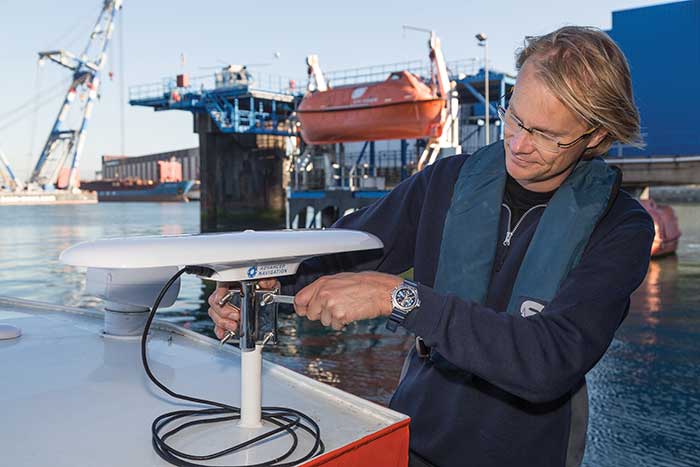
Advanced Navigation’s plug-and-play GNSS Compass was selected by Nortek for its new survey package. Nortek’s scientific instruments apply the Doppler principle to underwater acoustics to measure water in motion, such as currents and waves. The instruments are used by scientists, researchers and engineers worldwide, employed in demanding environments that require state-of-the-art instrumentation that is reliable and easy to use.
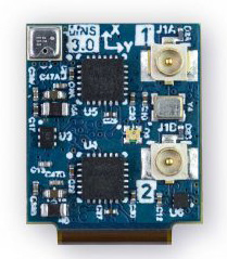
A vessel-mounted acoustic Doppler current profiler (ADCP) measures the velocity of currents beneath a moving vessel. To correct the measured values for vessel speed and direction, ADCP measurements require accurate velocity and heading information. Besides the use of bottom track within the ADCP itself, such information can be provided externally using a GNSS receiver and a non-magnetic heading source such as a gyro compass.
Nortek’s ADCP package — Signature VM — offers operational convenience and reduced complexity. As part of the package, Advanced Navigation’s GNSS Compass provides accurate dual-antenna GNSS-based heading that is not subject to magnetic interference. Its inertial navigation system (INS) can maintain accurate heading during GNSS outages of up to 20 minutes. “By making use of today’s modern Ethernet instruments, such as the Signature ADCP and the GNSS Compass, we can guarantee nanosecond time synchronization with Ethernet PTP protocol,” said Herman Huitema, VM product manager at Nortek. “Data from the ADCP can be exactly aligned with the GNSS Compass information.”
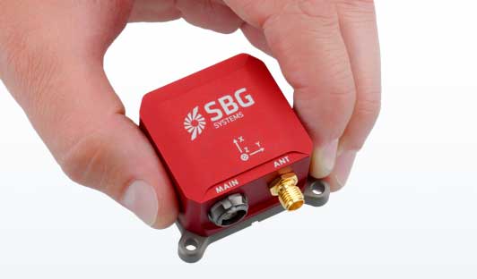
SBG Systems has built a program designed to sponsor student teams participating in competitions, as well as offer discounts for universities and research centers on inertial sensors and post-processing software.
Through the program, the company sponsors students participating in competitions in various fields, such as robotics, autonomous vehicles, UAV, rockets, unmanned and solar boats and more. This includes support during the competition, as well as during the installation of SBG’s latest inertial navigation systems in the teams’ vehicle prototype, the company said.
SBG’s Ellipse series is also eligible through its education program. The series is composed of SBG’s miniature inertial measurement units, attitude and heading reference systems and inertial navigation systems. In addition, the entire product line has been renewed. The new Ellipse INS/GNSS embeds a quad constellation, dual frequency, and dual Antenna RTK GNSS receiver to bring centimetric position and higher accuracy orientation in the smallest package, SBG added.
In addition to being compatible with CAN and ROS, the Ellipse Series’ sensors are compatible with SBG’s Qinertia Post-Processing Software, the SBG Systems’ in-house INS/GNSS post-processing software. Qinertia allows users to replay, analyze, improve their trajectories and access RTK corrections worldwide to bring their project to the centimetric accuracy.
SBG Systems designs and manufactures MEMS-based inertial motion sensing solutions. According to SBG, its products are ideal solutions for industrial and research projects such as unmanned vehicle control, antenna tracking, camera stabilization and surveying applications.
Miguel Amor, chief marketing officer, Hexagon’s Autonomy & Positioning Division
GPS World celebrates its 30th anniversary, and together we’ve seen huge leaps of innovation over the years. Reflecting on these developments, I wanted to share some of the contributions Hexagon | NovAtel made to support the evolution of the GNSS industry.
We began in 1978 in Alberta, Canada, in the telecommunications industry. In the 1990s, we shifted our focus to satellite receivers, choosing to forge ahead in GPS/GNSS technology. This decision would see NovAtel become one of the world’s leading manufacturers of high-precision GNSS components and systems developing multiple new patents and innovative solutions.
Our engineers have seen first-hand the growth of GPS and other satellite positioning systems worldwide, GNSS adoption across industries from aerospace to agriculture, and the present-day developments of precise positioning in autonomous applications. A rising tide raises all boats, and we helped foster the evolution of the industry through our goals of assured autonomy and positioning.
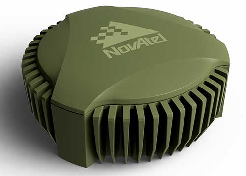
GAJT-710ML anti-jam antenna. (Photo: Hexagon)
Assured positioning means a reliable and robust solution you can trust. Technologies we’ve contributed to the broader industry include our GPS Anti-Jam Technology (GAJT) protecting users’ positioning, time and navigation, and SPAN technology, which expertly combines GNSS and inertial navigation systems (INS) measurements for seamless motion observations and a robust positioning solution. The capabilities of these technologies have been major contributors to the evolution of the GNSS industry.
Hexagon acquired NovAtel in 2007, and we’ve continued to grow and develop exciting new opportunities around the world where GNSS can grow, strengthen and improve applications in agriculture, automotive, defense, marine and many other industries. Our mission of assured autonomy and positioning encourages us to continue providing assured positioning in the most demanding environments and begin bringing autonomy to these markets.
GPS World has been a key player in covering these technological advancements for the past three decades. Together as an industry, we’ll continue innovating positioning and autonomy, and I’m excited to see how the industry will evolve over the next 30 years.
Northrop Grumman Corporation has successfully completed the critical design review (CDR) milestone for the Embedded Global Positioning System/Inertial Navigation System (INS)-Modernization, or EGI-M, program.
EGI-M provides state-of-the-art airborne navigation capabilities with an open architecture that enables rapid responses to future threats. The fully modernized system integrates new M-code capable GPS receivers, provides interoperability with civil controlled air space, and implements a new resilient time capability.
“The completion of this milestone is a key step in bringing necessary navigation capability upgrades to our warfighters,” said Brandon White, vice president, navigation and positioning systems, Northrop Grumman. “With its open architecture and government ownership of the key internal interfaces, EGI-M’s next-generation navigation solution allows the government to quickly insert emerging capabilities from third parties while maintaining cyber security and airworthiness.”
The F-22 is one of the lead platforms for EGI-M integration. (Photo: Staff Sgt. Carlin Leslie/U.S. Air Force)
Northrop Grumman’s unique, modular platform interface design enables backwards compatibility with existing platform footprint and interfaces (A-Kits), allowing current platforms to easily integrate and deploy Northrop Grumman’s EGI-M solution.
At the same time, EGI-M’s modular software and hardware, coupled with government ownership of key interfaces, allows EGI-M to benefit from rapid upgrades with best of breed software and hardware technologies now and in the future.
Northrop Grumman has been on contract for the engineering and manufacturing development (EMD) phase of EGI-M since November 2018. The CDR milestone marks the completion of detailed hardware and software design of the EGI-M product line.
The launch platforms for Northrop Grumman’s EGI-M are the F-22 fighter jet and E-2D early warning aircraft. Additional fixed-wing and rotary-wing platforms across Department of Defense and allied forces have already selected Northrop Grumman’s EGI-M as their future navigation solution.
The E-2D Hawkeye is an American all-weather, carrier-capable tactical airborne early-warning aircraft. (Photo: U.S. Navy)
Latest inertial navigation system serves new customer requirements in autonomous vehicles, mobile mapping, surveying and more
Photo: Honeywell
Honeywell is introducing the HGuide n380, an inertial navigation system (INS) that communicates position, orientation and velocity of an object — such as an autonomous vehicle or unmanned aerial vehicle (UAV) — even when global navigation satellite signals are unavailable.
Smaller, lighter and lower priced than previous Honeywell inertial navigation systems, the HGuide n380 is built using Honeywell’s rigorous design standards to withstand harsh environments in the air, on land or at sea.
“We recognized a need for a small, high-performance inertial navigation system in areas like 3D mapping, surveying and other applications where space is at a premium and performance cannot be compromised,” said Chris Lund, offering management senior director, Navigation and Sensors, Honeywell Aerospace. “We responded by developing the HGuide n380 inertial navigation system, which provides our customers with proven, cost effective inertial sensor technology, created for aerospace applications, but that can be integrated into almost any architecture.”
The new inertial navigation system is composed of Honeywell’s HGuide i300 inertial measurement unit (IMU), a GNSS receiver and Honeywell’s proprietary sensor-fusion software, which is based on the algorithms used for navigation on millions of aircraft every day.
Inputs from these components are fused together to determine position, orientation and velocity to deliver critical navigation information even in areas where a satellite signal is degraded or altogether unavailable, such as canyons, bridges, tunnels, mountains, parking garages or dense forests.
“As the industry evolves, Honeywell’s HGuide suite of IMUs and navigators will be a key enabler of emerging segments like autonomous vehicles, mobile mapping, precision agriculture, robotics and surveying,” Lund said.
During its development, the new product was placed in extreme environments to test ruggedness and was exposed to extensive factory calibration and compensation procedures that help ensure measurement accuracy and performance.
Honeywell has extensive experience in designing and building high-end inertial sensor and navigation systems and has used that expertise to develop a lower-cost portfolio of HGuide offerings to serve new markets and customer requirements.
To date, Honeywell has delivered more than half a million high-performance inertial sensors to serve as navigation aids on an extensive list of manned and unmanned vehicles, which include many air and spacecraft in use today.
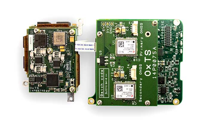
The xOEM v3 includes the architecture from the company’s IP65-encased xNAV v3 as well as a full range of software interfaces, providing integrators maximum configuration flexibility, real-time monitoring, post-processing and analysis. Software interfaces can be customized using the OxTS NAVsuite. Plugins can be created using the company’s NAVsdk, allowing the xOEM v3’s software to be easily packaged and included as part of a product.
The board set is compact at 150 grams, which enables manufacturers to seamlessly integrate and build a high-performance INS into their products, such as commercial mapping applications on land and in the air. Its light weight means more payload capacity for other critical components. An add-on lidar georeferencing software package is also available with a sophisticated boresight calibration tool.
The high-grade MEMS inertial sensors and real-time kinematic (RTK) capable GNSS receiver within the xOEM v3 board set deliver high performance capabilities. The board set provides 0.1° heading accuracy, 0.05° pitch/roll accuracy and 2 cm global position accuracy.
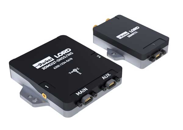
Parker LORD has launched the 3DM-GQ7 dual-antenna RTK inertial navigation system with multiple integrated aiding sensors and support for external aiding.
It has two integrated real-time kinematic (RTK)-capable multi-band multi-constellation GNSS receivers, integrated barometric pressure sensor, magnetometer, and hardware support for wheel odometry. It also has an application programming interface (API) for external sensor measurements.
The 3DM-GQ7 offers advanced sensor fusion for accurate measurements in challenging environments. It provides seamless operation during temporary GNSS signal outages and online tracking of inertial measurement unit (IMU) error sources for superior dead-reckoning.
An optional network RTK receiver, the 3DM-RTK, allows users to connect and communicate to the company’s SensorCloud RTK Connection network. This makes for an all-in-one solution (GNSS-INS + RTK + SensorCloud RTK).
3DM-GQ7 Features
High quality position, velocity and attitude estimates at rates up to 1 kHz
2-cm position accuracy (in good conditions with RTK corrections available)
0.1 degree roll/pitch accuracy; 0.25 degree heading accuracy with dual-antenna GNSS, depending on conditions
All-in-one system solution (GNSS-INS + RTK + SensorCloud RTK)
Applications include drones, autonomous vehicles and legged robots
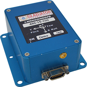
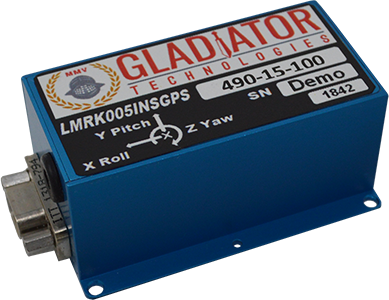
Gladiator Technologies’ low-noise inertial sensor and systems technology coupled with Velox high-speed processing are now integrated with a 72-channel GNSS receiver to provide compact GNSS/inertial navigation systems (INS) for accurate position, velocity and attitude.
The feature set was carefully selected to suit several positioning, navigation and timing (PNT) applications including flight control, navigation and stabilization for imaging, platforms and antennas.
The high-performance LandMark 60 INS/GPS and compact LandMark 005 INS/GPS both feature advanced sensor-fusion technology, combining GNSS position data with Gladiator Technologies’ low-noise, high output inertial sensors as well as barometric pressure and magnetometers.
Both products feature Gladiator Technologies’ proprietary Velox processing technology and extended Kalman filter (EKF), enabling precision position information during short-term GPS outages.
Velox Technology combined with the new EKF enable the LandMark INS/GPS products to have accuracy of less than 2 nautical miles per hour during short-term GPS outages.
The LandMark 60 INS/GPS is the top performing unit with +/- 0.3° heading accuracy and pitch/roll angle measurements of 0.1°. It is also available with an option for a real-time kinematic (RTK) GPS receiver.
The small and robust LandMark 005 INS/GPS is less than 35 square centimeters and is suitable for space-constrained applications that require a high standard of INS/GPS performance.
“Our low-noise sensor inputs to the EKF are enhanced by an adaptive estimation algorithm,” said Lee Dunbar, chief software architect. “This, along with extended precision for the nonlinear solution integrator, maximizes the accuracy of position, velocity and attitude. Customer configurable EKF parameters are present to allow optimization for their applications.”
“Leveraging our inertial capability into a complete INS/GPS package was a natural progression for our product line,” said Eric Yates, Gladiator Technologies’ new business development manager. “With the LandMark 005 INS/GPS and LandMark 60 INS/GPS we’re offering an exceptional MEMS-based INS/GPS that fits in the palm of your hand.”
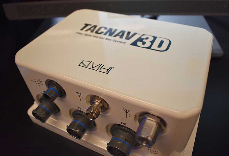
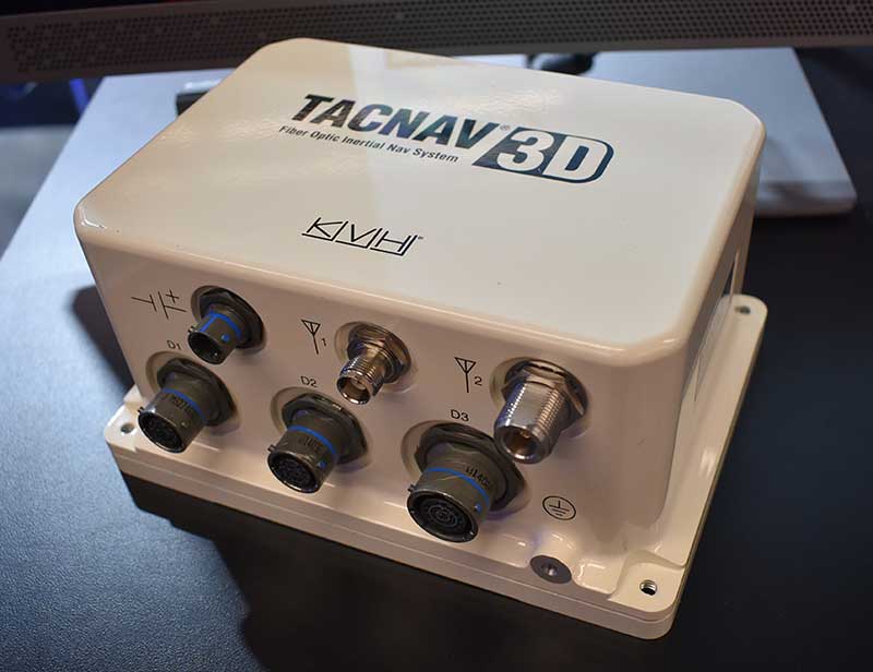
KVH Industries released its TACNAV 3D inertial navigation system, which includes an embedded GNSS and optional chip-scale atomic clock.
According to the company, the TACNAV 3D’s modular tactical design and flexible architecture allow it to function as either a standalone navigation solution or as the core of a multi-functional Battlefield Management System.
TACNAV 3D can integrate with a number of military GNSS systems and features one pulse per second timing assurance during GNSS signal loss, the company added. It also includes an iridium transceiver option that transmits and receives vehicle position, waypoint, and target location to and from a command center or other vehicles. It can receive and transmit data over ethernet, CANbus or RS-422 serial data bus.
“It incorporates a chip-scale atomic clock,” said Bill Houtz, business development — military and government for KVH Industries’ Inertial Navigation Group. “It has an embedded GPS, or we can work with other GPS external systems. It’s extremely flexible. It is an excellent SWAP-C alternative to the ring-laser gyros or other solutions on the market right now.”
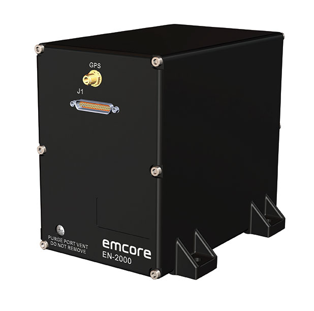
Emcore Corporation has launched the EN-2000 to the Emcore-Orion series of micro-inertial navigation (MINAV) systems.
The new EN-2000 will represent the pinnacle of performance in Emcore navigation systems, and realizes the company’s vision of a closed-loop, solid-state design that will deliver higher performance at lower cost than traditional RLG (ring laser gyroscope) navigation systems.
The EN-2000 expands Emcore’s navigation systems line that also includes the EN-1000 introduced in 2017. The Emcore-Orion series of inertial navigation system (INS) are designed for use in a broad range of defense, aviation and aeronautics applications.
The unit was introduced at the Paris Air Show, held June 17-20 at the Parc des Expositions Paris-le Bourget in Hall 6, Stand #C65.
Today, there is an ever-increasing premium being placed on modern navigation systems for improved size, weight and power (SWaP). Traditional RLG navigation systems placed a premium on accuracy and performance, but not SWaP. Typical RLG and FOG systems are large and heavy, ranging in volume from 330 in3 to 540 in3, weighing 13 to 22 pounds with power requirements of 25 to 38 watts.
Many modern weapon systems are now remotely operated, unmanned or man-portable and may need to operate where GPS is unavailable or denied. The compact EN-2000 is designed for these applications. It puts a premium on accuracy and performance, but also on smaller size, less weight and lower power consumption.
The new Emcore-Orion EN-2000 MINAV is a three-axis design using the company’s proprietary, next-generation solid-state optical transceiver with advanced integrated optics, combined with all new field programmable gate array (FPGA) electronics to deliver stand-alone aircraft-grade navigator performance at one-third the SWaP of legacy or competing systems.
The EN-2000 model comes in two standard versions, an IMU version and a standalone INS configuration. The INS version can gyrocompass to less than 0.7 milliradians and maintain near-GPS-level positional accuracy without the use of a GPS receiver. This makes it suitable for use in GPS-denied environments.
To provide customers with additional flexibility, the unit is also capable of being aided by an external GPS for applications where needed.
The Emcore-Orion EN-2000 is compact and lightweight, weighing less than 7 pounds, with very low power consumption of 10 watts. It can deliver twice the performance of the EN-1000 with the same form factor.
The low SWaP of the EN-2000 makes it a suitable inertial navigation system for unmanned aerial vehicles (UAVs), unmanned underwater vehicles (UUVs), unmanned ground vehicles (UGVs), manned aircraft, rotorcraft and dismounted soldier applications.
“With the introduction of the EN-2000, Emcore can now offer class-leading performance at a fraction of the size, weight and power of competing systems with increased reliability,” said David Faulkner, Emcore vice president and general manager of aerospace and defense. “Emcore’s goal of a true full navigation system that can replace older technology navigation systems in UAVs, UUVs, UGVs, manned aircraft and rotorcraft is fully realized with the introduction of the EN-2000.”
“Our Emcore-Orion series micro navigators improve dramatically on the size and cost of navigation and azimuth sensing equipment by utilizing affordable lightweight sensors that reduce overall system weight and increase accuracy,” added K.K. Wong, Sr., director of fiber optic gyro products for Emcore. “The digital interface is also fully programmable at Emcore’s factory enabling it to directly replace competing units.”
Systron Donner Inertial (SDI) has released an update to its SDN500 digital quartz MEMS GPS inertial navigation system (GPS/INS).
Introduced in 2011, the SDN500 is a platform extension of SDI’s proven, tactical-grade SDI500 IMU.
The modular, compact, 25 in3 SDN500 provides for maximum packaging flexibility in dense systems and delivers accuracies to within 1.0 mrad in attitude, 0.1 m/s in velocity and 3.9 meters spherical error probability (SEP), the company said.
The SDN500-xE product update provides a newer generation JF2 (C/A) Code GPS receiver and tightly couples the 1 PPS GPS signal to the SDI505 IMU synch pulse to improve heading performance and reduce jitter after long periods of operation without dynamic inputs. The specifications for the updated SDN500-xE will remain the same as the current SDN500-xD INS/GPS device.
The SDN500 offers superior tactical-grade performance integrating SDI’s latest generation quartz gyros capable of 0.5°/hr. bias in-run stability and exceptionally low ARW (0.02°/√ hr.), quartz accelerometers delivering 0.5 milli-g in-run bias stability and low VRW (80 µg/√ Hz.), plus high speed digital signal into a tightly coupled GPS-aided Inertial Navigation System for tactical navigation and geo-location applications.
Dime-sized INS with RTK paves the way for high accuracy in mass-market consumer applications.
Photo: Inertial Sense
Inertial Sense has released a new micro-sized inertial navigation system (INS) with precise real-time-kinematic (RTK)-level accuracy. The company says the new solution paves the way for high accuracy in mass-market consumer applications.
The new micro INS with RTK solution offers an accuracy of 2-3 centimeters using GPS positioning in combination with inertial sensors (including on-board sensor fusion).
Inertial Sense designs and manufactures precision INS+RTK GPS sensors that deliver fast, accurate and reliable altitude, velocity and position for a wide range of autonomous vehicle applications, the company said.
The new micro INS with RTK provides a high degree of precision for orientation and GPS in a tiny package. Standard INS/GPS sensors offer accuracy in the range of 1.5 to 2 meters. Inertial Sense’s micro INS with RTK offers accuracy of 2-3 centimeters.
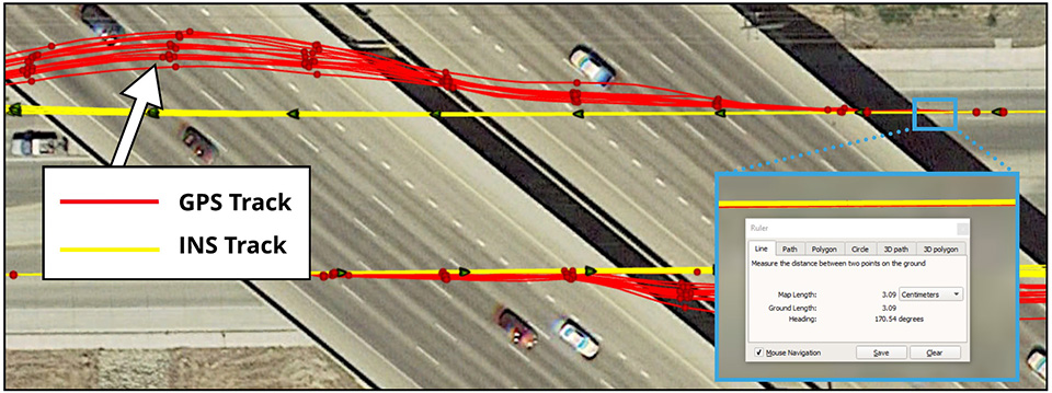
In the image above, a vehicle travels under an overpass. The 3-cm accurate RTK-inertial navigation track holds true to the vehicle’s position while the standard GPS signal is lost. (Image: Inertial Sense)
“The incredibly small size of our new micro INS with RTK sensor, in combination with its extremely affordable price point, will make this type of highly sophisticated technology accessible for general consumer applications for the very first time,” said Walt Johnson, founder and CTO, Inertial Sense. “We are offering RTK at a size, accuracy and price point that the market has never seen before.”
By optimizing the manufacturing processes for high volume applications, the micro INS with RTK sensor is as small and lightweight as a dime, and is available at a low price point.
Sensor fusion. Sensor data from MEMs gyros, accelerometers, magnetometers, barometric pressure and u-blox GPS/GNSS are fused to provide optimal position estimation. Data out includes angular rate, linear acceleration, magnetic field, barometric altitude and GPS time.
The miniature module provides orientation, velocity and position. Base station corrections data can be applied to achieve centimeter-level precision.
Autonomous vehicles. The sensor will enable the navigation of all types of autonomous vehicles with a very high degree of precision, Inertial Sense said.
Inertial Sense patented modules are currently being sold worldwide at volume for a broad variety of applications including:
Aerial surveys: UAV Payloads for 3D mapping, photogrammetry, orthomosaics
Gimbal stabilization and antenna pointing
3D motion capture and personnel tracking
Evaluation kits. Inertial Sense has bundled evaluation kits it says are simple to use and contain everything needed to begin logging RTK-accurate data. The evaluation boards can be utilized in both rover and base station configurations and include 900-mhz radios with onboard logging capabilities.