Tag: internet of things

  • Taoglas launches Edge Locate for cm-level GNSS positioning for IoT

    Taoglas launches Edge Locate for cm-level GNSS positioning for IoT

    Photo:
    Photo: Taoglas

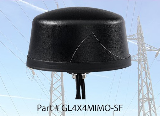
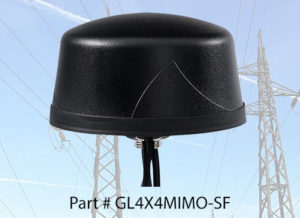
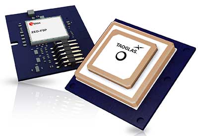
    Taoglas, a provider of next-generation internet of things (IoT) solutions, has launched Edge Locate, a GNSS L1/L2/E5 module that combines antenna, RF electronics and receiver technology to deliver reliable centimeter-level positioning.

    Taoglas, in partnership with u-blox, created a smart antenna that uses multi-band GNSS technology, providing between 1- to 3-centimeter-level accuracy.

    With Edge Locate, manufacturers can quickly and effectively build devices with centimeter-level positioning technology, without having to invest in costly and lengthy RF design, integration and testing processes.

    The device features multiband GNSS positioning that can be used in conjunction with cost-effective real-time kinematic (RTK) positioning capability.

    Traditionally, most IoT devices use single-band GPS technology, delivering on average 10-meter accuracy with existing GPS modules and antennas, Taoglas said in a press release. This enables location-specific, mission-critical services such as emergency response, smart infrastructure, precision agriculture and microbility mobility applications where precise location provides critical value to the IoT application.

    Taoglas can also consult and install the RTK network in any global location for any IoT use case.

    “Centimeter-level positioning is absolutely key to the next-generation of IoT enabled applications,” said Ronan Quinlan, Co-CEO of Taoglas. “Take an example from the burgeoning micro-mobility industry. When granting licenses from a trial, the city authorities would like to monitor the riders of e-scooters, ensuring riders are staying off footpaths, or parking in designated areas. The problem is that today’s legacy GPS solutions don’t often know which side of the road a scooter is on. Whereas with our solution, fleet operators can pinpoint within just a few centimeters where a device is located. We do this by working with our customers to enable the whole solution and we make sure it works reliably in real life.”

    Edge Locate can greatly accelerate the latest GNSS multiband product launch plans by offering a plug-and-play product that uses a common connector for integration into any electronics device. It also connects directly to the Taoglas Edge board for immediately connectivity options.

    Taoglas is exhibiting at Mobile World Congress Americas, Booth 2602 in the South Hall of the Los Angeles Convention Center.

  • Quectel achieves 5G data call over 5G mmWave module

    Quectel achieves 5G data call over 5G mmWave module

    Photo: Quectel
    Photo: Quectel

    Quectel Wireless Solutions has completed a data call over its 5G millimeter wave (mmWave) module that fully complies with 3GPP Release 15 5G NR standards.

    The 5G data call on Sept. 25 was made over a Quectel RM510Q-GL 5G module based on Keysight’s 5G testing device in a lab, paving the way for the upcoming 5G mmWave field tests and commercial deployment of 5G internet of things (IoT) projects.

    In addition, the move is a testament to Quectel’s leadership in 5G research and development capability and IoT innovations.

    Tailored for IoT/eMBB (enhanced mobile broadband) applications, Quectel RM510Q-GL features the Snapdragon X55 5G modem and supports mmWave and sub-6 GHz frequencies in both 5G standalone (SA) and non-standalone (NSA) operations.

    The M.2 module covers nearly all the mainstream carriers worldwide. Designed backward compatible with LTE-A and 3G networks, RM510Q-GL integrates multi-constellation GNSS receiver, eSIM, as well as high-speed interfaces such as USB 3.1 and PCIe 3.0, which make it suitable for globally deployed mobile devices including Always Connected PCs (ACPC), industrial PDAs, mobile gateways and more.

    AsusTek Computer Inc., a Taipei-based multinational computer company, is planning to use RM510Q-GL for its next-generation 5G mmWave laptops, according to Quectel. Leveraging its industry leading 5G modules and local technical support, Quectel will accelerate the time-to-market for AsusTek to enhance its competitiveness in the 5G era.

    Quectel will showcase commercial 5G modules at the Qualcomm 5G Summit in Barcelona, Oct. 14-16, and MWC Los Angeles (Booth 1236), Oct. 22-24.

  • New Arvento vehicle tracker uses u-blox to detect panic breaking

    New Arvento vehicle tracker uses u-blox to detect panic breaking

    imt.x1 uses u-blox positioning technology to deliver high levels of positioning sensitivity and accuracy.

    Photo: u-blox
    Photo: u-blox

    U-blox and Arvento Mobile Systems are launching the imt.x1 vehicle tracking system. The companies previously partnered on the Treyki Mini tracker.

    Arvento’s imt.x1 has a six-axis gyro sensor that can sense three-dimensional movement caused by emergency acceleration, panic braking and directional yaw and drift.

    With connectivity options including dual CANBus and Bluetooth, the system is also eCall compatible and captures and provides data for accident analysis and other vehicle tracking functions. The system also uses the next-generation powerful Arm-based microcontroller.

    This latest launch is yet another product of a successful, eight-year strategic partnership between Arvento and u-blox. “U-blox is more than a supplier,” said Özer Hıncal, Arvento’s general manager. “As a global leader in the IoT [internet of things] industry providing high-performance IoT modules, platforms and support services, u-blox is our trusted solutions partner, working closely with us to address customer demands and issues.”

    As for previous Arvento products, collaboration with u-blox was a key factor in the imt.x1 product development process. The system’s high position sensitivity and accuracy are based on integration of u-blox’s 2G, 4G and 5G-ready cellular modules as well as GNSS modules.

    The development of the imt.x1 aligns with Arvento’s vision and mission as a developer of advanced fleet telematics and vehicle tracking devices and will be available from August 2019.

  • Kolmostar releases low-power GNSS module JEDI-200

    Kolmostar releases low-power GNSS module JEDI-200

    JEDI-200 reduces the energy of getting one position fix by up to 150 times, according to the company.

    Photo: Kolmostar
    Photo: Kolmostar

    Kolmostar, a positioning technology company, has launched an ultra-low-power GNSS module at IoT World, which took place May 13-16 in Santa Clara, California.

    JEDI-200 reduces the energy for one position fix by up to 150x compared to traditional GNSS sensors, providing a positioning solution for location-based internet-of-things applications, the company said.

    JEDI-200 specification highlights include:

    • 10-mW ultra-low-power consumption (measured) @ 1 Hz navigation rate
    • 1-second ultra-fast time to first fix from cold start
    • 2-meter CEP high positioning accuracy
    • Supports GPS and Beidou constellations
    • 100-byte compressed ephemeris (EPH) to enable A-GPS with speedy download via LPWAN technologies such as LoRaWAN and NBIoT
    • High-performance cloud computing based on 50-byte raw position files for optimized radio transmission efficiency and minimum endpoint power consumption
    • Integrated SAW filter, stand-alone LNA and TCXO
    • 12 x 16 millimeter form factor for easy RF integration

    “JEDI-200 supports GPS as well as Beidou constellations,” said Tao Tong, co-founder and CEO of Kolmostar. “While achieving industry’s lowest power consumption, it helps our customers to achieve high accuracy even in dense urban canyon environment where existing GNSS modules on the market often drift due to multipath and other errors.”

    The JEDI-200 is designed specifically for IoT applications such as human and asset trackers (for bikes, scooters, vehicles, cargo, livestock, pets and more), smart wearables, smart farming and infrastructures,.

    Its reduced level of power consumption and its optimized efficiency with LPWAN technologies solve IoT endpoint deployment’s pain-point of needing frequent recharges or a large battery, enabling new possibilities in location-based IoT applications.

  • Bluetooth provides sub-1-meter location precision in new feature

    Bluetooth has added a new direction-finding feature to help meet the growing demands of the location services market.

    The feature, which allows devices to determine the direction of a Bluetooth signal, was added to Bluetooth in version 5.1 of the Bluetooth Core Specification, released Jan. 28.

    To make use of the direction-finding feature, Silicon Labs has released new software for the Wireless Gecko portfolio, a comprehensive connectivity solution for the internet of things (IoT).

    Silicon Labs’ commercial, industrial and retail customers can enhance their location-based services — indoor navigation, asset tracking, space utilization and point-of-interest engagement — using the direction-finding feature, the company said.

    The new feature supports multiple methods for determining signal direction including angle-of-arrival (AoA) and angle-of-departure (AoD).

    Silicon Labs’ implementation of the new Bluetooth feature enables detection of signal direction within 5 degrees.

    To date, Bluetooth asset tracking and indoor positioning solutions have typically provided location accuracy within a range of 3-4 meters. With the Silicon Labs Bluetooth 5.1 solution, developers can create products that improve location accuracy down to the sub-1-meter level, opening the door to applications previously not possible.

    “The Silicon Labs Bluetooth direction finding solution provides a huge leap in location services accuracy for the industry,” said Matt Johnson, senior vice president and general manager of IoT products at Silicon Labs. “The combination of the Silicon Labs wireless solution and the new features added in Bluetooth 5.1 will help developers transform industries and improve people’s lives.”

    In addition to improved location services, Bluetooth 5.1 also helps developers:

    • reduce power consumption with sleep clock accuracy updates.
    • improve smart home connection performance using GATT caching functionality.
    • optimize beaconing for Bluetooth mesh in crowded RF environments with the advertisement channel index feature.

    “The Bluetooth community continues to find ways to meet evolving market needs and open new opportunities,” said Mark Powell, Bluetooth SIG executive director. “The addition of Bluetooth direction finding demonstrates this commitment to drive innovation and support the incredible growth opportunity within the location services market.”

    Silicon Labs’ direction-finding software, including support for the AoA method, is available to customers through the Silicon Labs Simplicity Studio development kit.

  • Nestwave demos low-power GPS for IoT at Mobile World Congress

    Nestwave demos low-power GPS for IoT at Mobile World Congress

    AIworx machine learning and IoT technologies leverage digital twins’ analytics visibility for infrastructure asset performance. (Image: iStock.com/metamorworks via Bentley Systems)
    Image: iStock.com/metamorworks via Bentley Systems

    Nestwave has developed an ultra-low power, advanced GNSS solution for use in internet of things (IoT) applications.

    Nestwave, a Paris-based startup, is demonstrating its new low-power, high-accuracy GPS IP at Mobile World Congress, being held Feb. 25-28 in Barcelona, Spain.

    The software-based GNSS solution allows modem customers to add accurate position-based services to their modem platforms.

    When integrated with an IoT modem such as NB-IoT, Cat M1, LoRa or Sigfox, the solution offers low-cost geolocation for emerging applications such as asset tracking, smart factories and smart cities, without the need for an external GNSS chip.

    “After several years of development and based on a number of key signal processing breakthroughs, we believe Nestwave is well-positioned to provide a best-in-class solution for low-power IoT applications where position awareness is key,” said Rabih Chrabieh, Nestwave CEO. “We are excited to demonstrate our GPS solution, in collaboration with Cadence by leveraging their Tensilica Fusion F1 DSP platform at MWC this year.”

    “The Fusion F1 DSP is gaining traction with customers as a platform for low-cost, power-sensitive IoT communications standards like NB-IoT,” said Gerard Andrews, director of marketing for Tensilica products at Cadence.

    The Cadence Tensilica Fusion F1 DSP is designed for low-cost IoT applications requiring a single processor core that is proficient at both DSP and control-code workloads.

    Developed on a highly configurable architecture, the Fusion F1 DSP is specifically designed to excel at “always-on” processing, including wake-on-voice and sensor fusion applications.

    Additionally, the Fusion F1 DSP instruction-set architecture is very efficient at running narrowband wireless communications standards like BLE, Thread, Zigbee, 802.11ah, NB-IoT and GNSS.

    Visit the Nestwave/Cadence demo at the Cadence booth at Fira Gran Via, hall 6, stand 6L34.

  • OriginGPS multi-constellation module ready for IoT

    OriginGPS multi-constellation module ready for IoT

    OriginGPS, maker of small-format GNSS modules and cellular internet of things (IoT) systems, presented new products with customized IoT and GPS demonstrations at Embedded World 2019, Nuremberg, Germany, Feb. 26-28, Hall 3, Booth 3-121.

    OriginIoT systems enable developers to rapidly develop IoT products with stackable add-ons, while all data is configured from the cloud, and no additional embedded code or RF knowledge is required.

    OriginGPS’ latest release is the multi-constellation ORG1518-MK06 module. It combines low power modes for extended battery life, 8MB built-in Flash memory, AGPS support for extended ephemeris improving position calculation, and UART+I2C or UART+SPI interfaces.

    Selectable add-on sensor boards click on the OriginIoT cellular IoT system, offering backward compatibility with 2G, 3G, CAT1 and CAT M. (Image: OriginGPS)
    Selectable add-on sensor boards click on the OriginIoT cellular IoT system, offering backward compatibility with 2G, 3G, CAT1 and CAT M. (Image: OriginGPS)

    An ultra-sensitive integrated patch antenna easily switches over to an external antenna via an integrated RF switch.

    The ORG1518-MK06 is suitable for solutions requiring multiple antenna options, such as automotive aftermarket and agriculture applications.

    Addressing the global IoT market with fast data transmission, the OriginIoT NB-IoT/CAT M with 2G fallback will be suited to devices that are battery-powered and transmit data only occasionally, such as parking and agriculture applications, resulting in a very long sensor battery life, typically 10+ years. The new model will be released later this year.

    “The new products are based on OriginGPS patented technologies and retain the miniature footprint for which the company has become synonymous,” said Robert van Tilburg, vice president, Global Sales and Business Development,  OriginGPS. “We are excited to offer our customers additional features and options to choose from, enabling them to reduce overall solution costs. 2019 is going to be an exciting year with technology advancements facilitating our product offering with more personalized IoT and GNSS products.”

    OriginGPS partner Gemalto will also be presenting OriginIoT demos at Hall 3, Booth 3-438. Gemalto’s Cinterion LTE-M module is integrated in the OriginIoT systems to provide 2G, 3G, Cat1, Cat-M and NB-IoT cellular communication.

  • Peering behind the mapping curtain

    Peering behind the mapping curtain

    Photo: Mapbox
    Photo: Mapbox

    Location intelligence powers applications with data and “live maps” updated continuously.

    According to Forbes, 70 percent of telecommunications companies consider location intelligence critical to their success. The intelligence data is provided by specialists such as Google, Esri, Here and PlaceIQ.

    In January, Sprint and location intelligence startup Mapbox launched precision mapping technology with the Curiosity IoT network. The 5G network’s extreme bandwidth and low latency will allow Mapbox to collect higher volumes of richer data to create “live maps.” A live map is built not from traditional data surveys months or years before, but from data collected from hundreds of millions of location-enabled sensors that feed back information about the world in real time, including high-resolution video.

    Mapbox uses artificial intelligence (AI) to turn the massive data flows into a picture of real time transit paths that can be used for precise, up-to-date routing.

    Augmented Reality view from the Mapbox Vision SDK. (Image: Mapbox)
    Augmented Reality view from the Mapbox Vision SDK. (Image: Mapbox)

    According to Mapbox CEO Eric Gundersen, maps that constantly update are essential to the internet of things (IoT). “As maps guide new smart machines on IoT networks, you remove the human in the middle that used to compensate for differences between the map and the real world,” he said. “Precision mapping services need to reflect the world as it is, at that precise moment so that those smart machines can travel safely and efficiently.“

    According to Mapbox, smart machines such as drones and autonomous delivery carts will be able to make fast location and routing decisions using its detailed, updated maps.

    Other companies that use Mapbox’s location services include IBM, Lonely Planet, Square, Tableau and The Weather Channel.

  • PCTEL introduces Coach Wi-Fi/GNSS multi-band antenna for IoT

    PCTEL introduces Coach Wi-Fi/GNSS multi-band antenna for IoT

    Photo: PCTEL
    Photo: PCTEL

    PCTEL Inc. released at DistribuTECH a new dual-band 802.11ac/p MIMO antenna that helps boost data rates and reliability for utility networks, intelligent transportation systems and other industrial IoT (IIoT) applications, according to the company.

    PCTEL’s Coach 4×4 Wi-Fi/DSRC GNSS multi-band antenna is designed for both mobile and fixed deployments, enabling smart grids, mobile workforce communications, and advanced automation technologies across a variety of industries.

    The antenna also supports Dedicated Short Range Communications (DSRC), a common interoperable safety standard for vehicles.

    “PCTEL’s latest antenna will enable the future of the IIoT,” said Rishi Bharadwaj, PCTEL COO. “For example, advanced smart grids utilizing Coach antennas could reduce outages and efficiently manage alternative energy sources.

    “Coach antennas also provide mobile connectivity for applications such as DSRC, which has the potential to revolutionize road safety. Those are just some of the possibilities. PCTEL’s advanced RF design and environmental testing capabilities enable us to deliver superior 4×4 MIMO performance and exceptional durability for the most demanding applications,” added Bharadwaj.

    This new low-profile antenna features four-port 2.4/5-GHz coverage along with PCTEL’s unique high rejection GPS/GLONASS technology for network timing and tracking, all in a single IP67-rated housing.

    It supports a variety of wireless technologies, including broadband mesh networks, 802.11ac Wi-Fi and 802.11p DSRC Wireless Access in Vehicular Networks (WAVE) standards for direct vehicle-to-vehicle (V2V) and vehicle-to-infrastructure (V2I) communications.

    This is the latest in PCTEL’s Coach antenna series. Coach antennas have been deployed in a variety of mobile and IIoT applications around the world. Their UV-stable design facilitates maximum installation flexibility without antenna orientation restrictions, the company said.

    PCTEL is displaying its Coach4x4 Wi-Fi/DSRC GNSS multi-band antenna Feb. 5-7 at DistribuTECH, booth 11750, in New Orleans. It is available now to order using part #GL4X4MIMO-SF.

  • Averna’s latest development tools accelerate IoT deployment

    Averna’s latest development tools accelerate IoT deployment

    Image: Averna
    Image: Averna

    Averna has launched a series of development tools that enable the real-time monitoring of assets.

    The Averna ConnexThing Toolkits enable customers to quickly connect new and existing manufacturing test assets to PTC’s ThingWorx Industrial IoT Platform.

    Each toolkit targets a specific programming language or test sequencer to accelerate the implementation and deployment of an internet of things (IoT) solution with ThingWorx.

    The ConnexThing Toolkit for NI TestStand, which is available for download now, streamlines the connection between TestStand’s ready-to-run test management software and ThingWorx’s innovative end-to-end IoT platform. It comes complete with templates, data shapes, widgets and dashboard examples that easily link test stations.

    The ConnexThing Toolkit for NI TestStand:

    • accelerates integration of ThingWorx with TestStand
    • enables easy monitoring of test stations and asset management using the configurable ThingWorx dashboard tool
    • orchestrates bi-directional communication
    • provides guidance for clean code and architecture.

    “The Averna ConnexThing Toolkit is the first in a series of new operational technology (OT) solutions designed to help clients gain insight on manufacturing and test processes and deploy Smart Connected Operations,” said Jean-Levy Beaudoin, VP Platforms & Innovation for Averna. “By leveraging the power of PTC’s ThingWorx Industrial IoT Platform together with our test assembly automation and machine vision expertise, Averna is uniquely qualified to help organizations achieve their digital transformation, enabling further productivity and quality improvement.”

    “PTC is pleased to have Averna in the PTC Partner Network, allowing for their recognized quality and test expertise to be made readily available to ThingWorx customers,” said JP Provencher, vice president of manufacturing strategy and solutions at PTC. “The ThingWorx extensions they have built help manufacturing companies improve test and quality processes by making them connected, real-time, predictive, and augmented.”

    The Averna ConnexThing for NI TestStand is available to download now as a free 90-day trial, directly from the PTC Marketplace or Averna website.

  • Bentley Systems to acquire AIworx for machine learning, IoT

    Bentley Systems to acquire AIworx for machine learning, IoT

    Bentley Systems has entered an agreement to acquire Quebec City-based AIworx, provider of machine learning and internet of things (IoT) technologies and services.

    Bentley Systems is the leading global provider of software solutions to engineers, architects, geospatial professionals, constructors, and owner-operators for the design, construction, and operations of infrastructure.

    The addition of AIworx brings advancements in data collection and analysis to leverage infrastructure engineering digital twins, continuously updated with real-time contextual information, to optimize productivity, operations and maintenance, Bentley Systems said.

    Bentley Systems also announced the acquisition of ACE enterprise Slovakia, provider of innovative technology solutions to interface with enterprise resource planning (ERP), enterprise asset management (EAM), and geographical information systems. ACE enterprise has been a technology partner of Bentley Systems, and the ACE Enterprise Platform is used for the Bentley AssetWise connector that is certified for both SAP ERP and SAP HANA.

    AIworx machine learning and IoT technologies leverage digital twins’ analytics visibility for infrastructure asset performance. (Image: Bentley Systems)
    AIworx machine learning and IoT technologies leverage digital twins’ analytics visibility for infrastructure asset performance. (Image: Bentley Systems)

    “AIworx has been providing machine learning and IoT technologies and services to help organizations generate, understand, and act on data so they can make better business decisions,” said Andre Villemaire, co-founder and president of AIworx.

    “The biggest opportunities we’ve worked on have to do with improving infrastructure asset performance on an industrial scale, by way of the data from connected machines, instrumentation, sensors, and communications systems — and we’re excited to dedicate ourselves to that advancement,” Villemaire continued. “Now, by incorporating our tools into Bentley’s services for digital twins, we enable infrastructure operators to multiply the potential benefits of machine learning and IoT.”

    “Machine learning and IoT technologies have created the opportunity for profound improvements in productivity and efficiency of infrastructure,” said Francois Valois, vice president of portfolio development for Bentley Systems. “Our new colleagues from AIworx have already been delivering on this potential, and now, leveraging the analytics visibility, which Bentley’s digital twin cloud services uniquely provide, these advancements from going digital will accelerate exponentially.”

    Alexander Cimbalak, founder of ACE enterprise, said, “We have enjoyed our partnership with Bentley to provide enterprise connectors and are very excited to be part of Bentley and also now to enable Bentley’s digital twin cloud services to uniquely synchronize with infrastructure assets’ enterprise IT, OT, and ET data sources.”

    Alan Kiraly, senior vice president, asset performance for Bentley Systems, said, “ACE enterprise has consistently overcome IT interoperability challenges for us at Bentley. Now, as colleagues, this talented team will enable us to continue to expand the scope and breadth of information that can be accessed through AssetWise and digitally aligned within infrastructure digital twins.”

  • U‑blox and ERM launch vehicle-tracking device with built-in Wi‑Fi hotspot

    U‑blox and ERM launch vehicle-tracking device with built-in Wi‑Fi hotspot

    Photo: ERM/u-blox
    Photo: ERM/u-blox

    U‑blox has released the StarLink TrackerWi‑Fi, an advanced vehicle-tracking device produced by ERM Advanced Telematics, a provider of device-based telematics solutions.

    The device combines u-blox GNSS, 4G and Wi-Fi technology, eliminating the need to equip vehicles with a separate mobile Wi‑Fi hotspot.

    According to the companies, the StartLink TrackerWi‑Fi is suitable for applications for connected cars, telematics, vehicle diagnostics, fleet management, vehicle security, usage-based insurance, and rental and leasing service companies.

    The internet of things (IoT) and connected-car initiatives are providing rental car companies and transportation and logistics firms with tools to track vehicles, preemptively detect and diagnose disturbances from a distance, and monitor the behavior of their drivers in real time. ERM has more than 1.8 million vehicle fleet-tracking devices deployed on roads world-wide.

    As onboard Wi‑Fi becomes increasingly widespread, many companies are fitting vehicles with Wi‑Fi hotspots to offer drivers and passengers internet access. With its integrated Wi‑Fi hotspot, ERM’s StarLink TrackerWi‑Fi lets users tap into the cellular 4G connectivity to transfer telematics data to the fleet manager. This makes it possible to send real-time telematics data to the driver’s smart device or onboard infotainment system, and it also reduces the number of SIM cards needed from one per device to one per vehicle.

    Sourcing the GNSS tracking, cellular 4G LTE, and Wi‑Fi technology from u-blox played a key role in achieving the device’s fast time to market. By using u‑blox’s pre-tested positioning and communications modules with integrated software, the manufacturer was able to cut the time needed for production and development by several months.

    “We saw an opportunity to provide more values to our customers by adding Wi‑Fi hot spot functionality to our StarLink Tracker, our leading telematics product, but knew that we had to be quick to stay ahead of the game,” said Kfir Lavi, senior vice president of ERM Advanced Telematics.

    “Our partners are always at the top of our priorities, and we are working to adapt our offerings to the market demands and the changing needs of their customers. Working with u‑blox as the provider of the positioning and wireless communication technology helped us move from concept to commercialization in under six months and provide our partners with an advanced product in a short time,” Lavi said.

    “This successful collaboration demonstrates that we have evolved from a provider of individual technologies, namely GNSS positioning, cellular 4G connectivity, or short range radio communication, to a provider of solutions that bundle these technologies,” said Thomas Seiler, CEO of u-blox. “We are seeing increased demand for such bundled solutions and are convinced that the close integration of our technology portfolio offers our customers the unique ability to jump-start even challenging projects on extremely short notice.”