Tag: internet of things

  • Swift Navigation presents, exhibits at Xponential 2018

    Swift Navigation is exhibiting and speaking at AUVSI Xponential 2018, being held this week in Denver.

    Swift Navigation is a ​​San ​​Francisco-based ​​technology ​​firm ​​building centimeter-accurate ​​GPS ​​technology ​​to ​​power ​​a ​​autonomous ​​vehicles.

    Xponential 2018, held at the Colorado Convention Center, is the largest and most comprehensive trade show for unmanned systems and robotics. Learn more about the convention and see GPS World’s coverage.

    On Wednesday, May 2, 3:15–3:45 p.m., Swift Navigation’s Product Manager Akshay Bandiwdekar and Sales Executive David Fischer will lead an educational session on “The Role of RTK in the Autonomous System Sensor Suite.” Join them in Room 203, where they will discuss how one sensor — a multi-band, multi-constellation RTK GNSS receiver — is a unique sensor in autonomy as the only sensor within the autonomous vehicle sensor suite to deliver absolute position, velocity and time.

    Swift Navigation’s Duro.

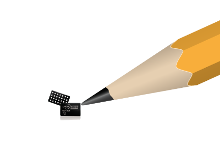
    At Booth 3311 in the exhibit hall, Swift Navigation is featuring its multi-band, multi-constellation real-time kinematic (RTK) GNSS receiver, the Piksi Multi GNSS Module, and its Duro Ruggedized Receiver, an easy-to-deploy GNSS sensor that is protected against weather, moisture, vibration, dust, water immersion and the unexpected that can occur in long-term outdoor deployments, such as for robotics applications.

    The company will also be featuring its newest Internet service Skylark, a cloud-based GNSS corrections service that delivers affordable, fast, centimeter-level accuracy and eliminates the complexity of deploying and maintaining GNSS networks.

    Fergus Noble

    Webinar on Location and IoT

    Those unable to attend Xponential 2018 but interested in Swift Navigation’s recent product announcements or looking to learn more about what is next for the company can join Swift’s upcoming webinar with GPS World: Location’s Role in the Internet of Things (registration is free).

    Oliver Cameron

    The webinar takes place on May 17 and features Fergus Noble, co-founder and CTO of Swift Navigation, along with Oliver Cameron, co-founder and CEO of Voyage — a company that deploys self-driving taxis in private communities across North America and uses both Skylark and Piksi Multi in its real-world autonomous driving application.

    “Xponential 2018 is the ideal venue for Swift to showcase its end-to-end ecosystem of products and cloud services, including our most recent innovation, Skylark,” said Diana Schlosser, executive vice president of marketing at Swift Navigation. “We are excited to demonstrate our low-cost, centimeter-accurate GNSS solutions to the unmanned systems industry.”

  • STMicroelectronics sensors validated for Alibaba IoT

    STMicroelectronics has confirmed the validation of its LSM6DSL 6-axis inertial sensor and LPS22HB pressure sensor for the Alibaba internet of things (IoT) ecosystem, which enables users to create complete IoT nodes and gateway solutions with better time to market.

    Launched in 2017, AliOS Things is a light-weight embedded IoT operating system developed by Alibaba. The company recently released AliOS Things v1.2, which includes a sensor-based component called uData.

    The ST sensors that have passed the AliOS validation have been integrated in uData, and the two companies are cooperating on the development of IoT systems that aim to improve end-user experiences.

    The LSM6DSL is a system-in-package featuring a 3D digital accelerometer and a 3D digital gyroscope that operates at 0.65 mA in high-performance mode and enables always-on low-power features for an optimal motion experience for the consumer.

    According to the company, high robustness to mechanical shock makes the LSM6DSL the preferred choice of system designers for the creation and manufacturing of reliable products. The LSM6DSL supports main OS requirements, offering real, virtual and batch sensors with 4 Kbytes for dynamic data batching.

    The LPS22HB is an ultra-compact piezo-resistive absolute pressure sensor that functions as a digital output barometer. Dust-free and water-resistant by design, the sensor enables high accuracy and low-power operation. It is available in full-mold package with silicon cap and six 20-µm holes guaranteeing sensor moisture resistance, relative accuracy of pressure measurement 0.1 mbar, and very low power consumption (12 µA in low-noise mode).

    “The validation by Alibaba of ST’s LSM6DSL and LPS22HB sensors is an important achievement,” said Collins Wu, marketing director, Analog and MEMS Group, Greater China & South Asia, STMicroelectronics. “Creating and connecting nodes quickly and securely is facilitated by the holistic platform of AliOS, which cuts time to market for users and allows them to create IoT systems in China quickly for applications in smartphones, smart watches, smart locks, smart parking and beyond. On top of this, Alibaba is collaborating closely with ST to integrate more products in the platform, offering compelling IoT solutions for customers.”

  • Telit releases two modules for European IoT

    Telit’s two latest modules are aimed at the European internet of things (IoT) market.

    Modules WE866E4-P and ME910C1-E2 are designed to meet European specifications requirements, providing the ability to bring advanced IoT applications to market such as smart buildings, smart energy, industrial applications, medical devices and others.

    “Our modules were designed with the European market in mind, eliminating the guesswork associated with what standard to use for IoT projects in the region,” said Yossi Moscovitz, Telit president of products and solutions.  “We are providing the industry the ability to digitally transform by creating new opportunities for our customers to achieve innovation. We’re pleased to be a key part of enabling the promise of Smart IoT that we are seeing during this week’s conference.”

    The WE866E4-P is a fully integrated dual-band, dual-mode combo Wi-Fi (802.11 a,b,g,n) and Bluetooth Low Energy (BLE) 5.0 module, with an small footprint (285 sq. mm) that provides a cost-effective way for manufacturers to add wireless connectivity to the products. It has an integrated tri-core system-on-chip with dedicated CPUs for IoT applications, Wi-Fi and BLE.

    The module is self-contained with full Wi-Fi, BLE and TCP/IP networking stacks along with a complete suite of security features such as secured boot, Flash encryption, copy protection, HTTPS and WPA/WPA2 personal and enterprise security modes.

    The ME910C1-E2 is a member of Telit’s flagship xE910 module family delivering 4G radio access technology in the 28.2 x 28.2 x 2.2 mm family form factor. This module increases the addressable market for LTE technology to include a broad range of new applications and use cases best served with lower maximum data rate, ultra-low power, reduced complexity and cost, and is capable of Cat M1, NB-IoT and 2G fallback. Examples of use are smart meters, industrial sensors, health-care monitors, home automation, asset tracker and other low-data-rate IoT devices.

    For more information please visit Telit during this week’s Smart IoT Conference in London at Stand T2865.

  • Software-based GNSS receiver available on Cadence digital signal processor

    A software-based GNSS receiver from Galileo Satellite Navigation (GSN) is now available for the Cadence Tensilica Fusion F1 digital signal processor (DSP).

    The software-based GNSS receiver allows customers to add full GPS functionality with design flexibility and long-term upgradeability at a minimal cost, low power and no physical size to today’s cost-sensitive internet of things (IoT) applications, according to Cadence Design Systems.

    To get the lowest possible power, GSN accelerated the performance of its GPS software receiver by creating several custom instructions to run on the Tensilica Fusion F1 DSP. As a result, the GPS software requires less than 110 MHz for full 12-satellite functionality.

    Additionally, with this software-based solution, customers can reduce the overall processor requirements to meet less-demanding location-based use cases such as asset tracking.

    “The Tensilica Fusion F1 DSP delivers outstanding performance for the implementation of our GNSS receivers, providing a low-power footprint required for IoT applications,” said Eli Ariel, CEO at GSN. “This enables customers to easily upgrade their Fusion F1 DSP-based designs to future satellite systems such as Beidou, GLONASS and Galileo via software. By leveraging several customized instructions in the Fusion F1 DSP, we were able to keep the required processor speed at the same frequency compared to DSPs with more than three times the processing power.”

    “GSN’s software-based approach for GNSS allows our Fusion F1 DSP customers to precisely scale their GNSS receiver requirements to meet their applications needs,” said Gerard Andrews, group director marketing, at Cadence. “The availability of GSN’s technology on this low-power DSP platform allows our customers to add location-based services at minimal cost and power.”

    The Tensilica Fusion F1 DSP offers low-energy, high-performance control and signal processing for a broad segment of IoT/wearable markets. This highly configurable architecture is specifically designed to excel at always-on processing that requires a merged controller plus DSP, ultra-low energy and a small footprint.

    The DSP is efficient in running the narrowband wireless communications standards typically associated with IoT device communications, including protocols such as Bluetooth Low Energy, Thread and Zigbee using IEEE 802.15.4, Wi-Fi 802.11n and 802.11ah and GNSS.

  • OriginGPS releases LTE-M system for low-power IoT products

    OriginGPS has chosen Gemalto’s Cinterion LTE-M wireless module to build its latest miniature OriginIoT system. Gemalto, a digital security company, designed the module for low-power applications requiring high security.

    OriginIoT systems are generic cellular internet of things (IoT) systems that simplify IoT product development and slash development resources.

    The systems include communication hardware, a GNSS module, embedded software and a novel interface to OriginIoT add-ons that accommodate multiple sensors and other peripheral devices.

    OriginGPS signal-to-noise technology is leveraged to deliver superior GNSS and cellular matching, facilitating excellent performance in noisy environments, while the OriginSmart software enables cloud-based programming, relieving developers from writing embedded code.

    The OriginIoT LTE-M system (ORG2101) has a 15 percent smaller footprint than the previous 2G and 3G models, and will be pre-certified with selected operators.

    The low-power, wide-area Cinterion LTE-M module supports more than 10 frequency bands from a single hardware device, eliminating the need for multiple variants. The module protocols can run on the same hardware, thus providing a future-proof path for additional OriginIoT models.

    “To save resources and stay competitive, such easy to develop low power solutions are essential for today’s IoT products,” said Andreas Haegele, senior vice president of IoT products for Gemalto. “We are glad to see that OriginGPS is expanding the market by offering accessible, affordable IoT products that are backed by Gemalto reliability and high quality,”

    “We designed the OriginIoT LTE-M system to address market pains, and so our new offering includes low power consumption, superb GNSS/cellular matching, interfaces to multiple connectors, and software to enable developing from the convenience of the cloud,” said Robert van Tilburg, VP Global Sales and Business Development of OriginGPS. “These features serve to simplify and shorten IoT projects. Gemalto’s Cinterion IoT module enables OriginGPS products to retain their world’s smallest footprint, while enhancing their security and extending end-product life.”

    OriginGPS will be showcasing its GNSS modules and OriginIoT systems at Embedded World, Feb. 27 – Mar. 1, in Hall 3, Booth 121.

  • Hoopo to provide low-power geolocation for IoT

    A new company, hoopo, has launched to supply an innovative, accurate geolocation solution for low-power wide area (LPWA) networks. The solution would improve precision for low-power Internet of Things (IoT) asset tracking.

    Hoopo’s geolocation enables companies to locate their valuable assets without the significant cost or battery consumption that can be associated with GPS. hoopo’s IoT solutions help companies precisely track specific assets in areas such as shipping ports, airports, car dealer lots, cattle ranches and other asset-dense areas.

    Hoopo has received $1.5 million in funding to further grow its business from a group of investors, including the initial investors in Mobileye; Israeli investor Zohar Gilon; and Ben Marcus, CEO of AirMap.

    The need to understand and quantify asset location is quickly becoming a requirement for the enterprise and industrial IoT. However, the accuracy of today’s low-power geolocation isn’t precise enough to deliver on the full promise of the IoT.

    LPWA networks are becoming the driving force behind smart city and other IoT applications because of their low-cost, low-power consumption, and high-coverage capabilities in rural and urban environments. The long battery life of LPWA devices allows businesses to deploy a maintenance-free device in the field for several years.

    “Hoopo is addressing a real business need of companies around the world: cost-effective, yet precise, tracking of their valuable assets with longevity of battery life up to 10 years in the field,” said Ittay Hayut, CEO of hoopo. “LPWA checks off all of the boxes companies need in terms of cost and coverage, and hoopo’s solutions work alongside these LPWA networks to help businesses keep their assets safe, anytime and anywhere.”

    Hoopo’s solutions are based on a patent-pending triangulation method that uses LPWA data transmissions to generate a precise location. The solutions suite includes low-cost LPWA gateways and devices, as well as a platform for management and real-time notifications. Companies can receive on-demand geolocation, establish geofences, receive movement alerts, and more, ensuring the protection of their valuable assets.

    “Hoopo’s geolocation technology reveals new business verticals that were limited or impossible when using existing technologies because of their high-cost and significant power consumption,” said Menashe Terem, CEO at Tri-logical, a provider of tracking and management solutions.

    “Early applications such as asset tracking are just the beginning of what advances in geolocation will enable,” said Eli Fogel, former CTO at Intel and hoopo investor. “Just as the advent of GPS launched a wealth of applications that no one ever thought of before, such as location-based advertising, there are future applications that this next generation of geolocation technology will enable. We’re excited to see what new applications emerge as customers embrace these new precision location capabilities.”

    Hoopo is displaying at Mobile World Congress in Barcelona Feb. 26-March 1 in Hall 5, Stand 5D81.

  • With Unicore, BeiDou navigates its way to global CES stage

    UM442 Module.

    With the successful launch of newest BeiDou-3 navigation satellites, Beidou’s pace of globalization is quickening. As a provider of China’s domestic GNSS core products, Unicore Communications brought its full range of products to the Consumer Electronics Show (CES), which took place Jan. 9-12 in Las Vegas.

    Unicore’s exhibits are targeting intelligent drive and the internet of things (IoT).

    UM442 Evaluation Kit: UM442-BOX2 evaluation box, navigation antenna x2

    For intelligent drive, Unicore is showcasing its UM482 high-precision GNSS module, which is designed for high-end L3 self-driving and robots.

    Unicore also is introducing a cost-effective low-power GNSS module — UM442 — which is suitable for L2 ADAS applications and community-based GNSS navigation and maps.

    UM442 is a cost-efficient high-precision real-time kinematic (RTK) and heading module that can simultaneously track GPS, BDS, GLONASS and Galileo. It also supports SBAS and QZSS.

    Based on high-performance data-sharing technology and the simplified operation system of the Nebulas II chip, the UGypsophila RTK algorithm dramatically optimizes matrix processing. Therefore, the UM442 can track many more satellites and shorten the initialization time to 5 seconds.

    Satellite view during a UM442 road test using the UGypsophila RTK algorithm. UM442 achieves centimeter-level RTK positioning using a low-cost ceramic antenna.

    With on-board MEMS and the U-Fusion integrated navigation algorithm, UM442 can achieve accurate and reliable positioning even in the most challenging environments such as urban canyons and tunnels.

    UM442 also provides attitude information such as rolling angle and pitching angle, which is suitable for many new applications such as community-based navigation maps and ADAS. Even with a low-cost ceramic antenna, the UM442 can achieve centimeter-level RTK positioning, as well as a 0.2-degree/1-meter baseline heading accuracy.

    At CES, Unicore plans to introduce BeiDou products into the large volume market of consumer electronics. Ufirebird is an ultra-small, ultra-low-power multi-GNSS positioning system-on-chip (SoC), using 28-nm technology. The chip supports BDS, GPS, GLONASS and Galileo signals, and the software can be extended to support WAAS/QZSS/EGNOS/MSAS/GANGAN enhanced signals.

    Unicore’s UFirebird-UC6226 low-power GNSS SoC is designed for mobile devices.

    Two packaging methods are available: WLCSP and QFN40. For WLCSP packaging, the chip size is only 1.73 x 2.87 mm, and for QFN40 packaging, the chip is AEC-Q100 compliant, aimed for highly reliable automotive-grade applications.

    UC6226 is equipped with a built-in sensor hub capable of providing access for multiple sensors for fusion positioning. It supports Wi-Fi, Bluetooth, GNSS hybrid positioning, and better than 1-m differential positioning accuracy.

    Compared with Unicore’s previous generation GNSS SoC, UC6226 has reduced power consumption by 60%. The minimum tracking power consumption is lowered to 18 mW, significantly improving battery endurance.

    With a built-in anti-jamming module, LNA and -162dB sensitivity, UC6226 can maintain accurate and precise positioning under complex environments.

    UC6226 has been successfully applied by China’s bicycle sharing companies. In addition, the chip will be used in intelligent watches, smartphones, smart cameras and many other IoT devices requiring smaller size, lower power consumption.

  • OriginGPS creates IoT-connected baseball

    OriginGPS teamed with Friendly Technologies, an internet of things (IoT) and device management company, and Humavox, a wireless charging expert, to create an IoT-connected baseball in six weeks.

    Friendly’s IoT platform interfaces the OriginIoT (cellular IoT) system to enable communication, management and a graphical user interface, while Humavox’s compact Wi-Fi-charging bowl re-energizes the system.

    The demonstration — developed in six weeks without a single line of embedded code or RF engineering — was showcased at CTIA Mobile World Congress 2017, in San Francisco Sept. 12–14.

    The OriginIoT effectively resolves inherent costly issues to IoT developments — namely long project cycles and required embedded software expertise. It expedites development cycles, and eliminates the need for embedded coding and RF engineering, resulting in substantial cuts in development resources, the companies said. With OriginGPS’ cellular-GNSS integrated in the IoT cellular system, the smart baseball is a proof of concept for rapid and accessible IoT development.

    Friendly’s One-IoTTM platform enables service providers to manage the data and configuration of millions of devices on a single platform, accelerating deployment and streamlining IoT service management, while cutting operational costs.

  • Telit, Husqvarna roboticize for park sustainability

    Mower-maker Husqvarna has installed a wireless sensor device co-developed by Telit and Wireless System Integration (WSI) in its city robotic mower pilot program. Cities are using the Husqvarna mowers to collect data about the environment, the quality of air, water, and levels of light and sound, while maintaining the cities’ green spaces, saving time and money, reducing emission and noise pollution.

    A Husqvarna robotic mower patrols a lawn along Prince’s Street in Edinburgh, Scotland. Equipped with a GPS-enabled Telit module, it gathers real-time sensor data on the city’s green space environmental conditions.

    In parks in seven cities — Edinburgh and London in the United Kingdom, Gothenburg and Stockholm in Sweden, Almere and Leeuwarden in the Netherlands and San Francisco in the United States — mowers autonomously cut the grass daily and collect real-time data on UV radiation, air quality, ambient noise, luminosity and vibration.

    The sensor box, designed by Telit, is mounted on top of the mower, uses the robot’s main battery for power supply, and recharges whenever the robot returns to its base. The sensor box transmits the data using Telit’s HE910-G cellular module which includes a GPS L1 receiver with reported 3-meter accuracy to acquire mower position.

    Telit HE910 cellular module has GPS option.

    Geofencing is enabled for the mower as well as location-based alarms to disable it should it be moved without authorization. To ensure public safety, sensors detect any nearby objects, including people and animals, causing machines to turn away.

    Telit’s global Internet-of-Things (IoT) connectivity data plans and platform seamlessly connect, manage and deliver the environmental data in a ready-to-use format.

    Environmental Gains. One of the biggest roadblocks to reach the United Nations Sustainable Development Goals is the lack of data. Cities need better environmental data to improve health and create cities people want to live in. The project measures the environmental gains and potential time savings of mowing public lawns with robotic mowers. The test will measure the reduction of noise pollution as well as direct emissions when replacing petrol-powered products with battery driven robotics.

    In cooperation with Husqvarna, Quantified Planet, an organization that links innovation to science, receives the data and publishes it for citizens to review. The cities can then analyze the environmental data sent by the robots and implement programs to improve the health of its citizens, based on these insights.

    “This new data can provide insights and innovation on how to develop and improve sustainable open green spaces which impact the citizens living nearby,” said Maja Brisvall, CEO, Quantified Planet.

    “The need for green spaces is growing more and more in urban areas. The pilot program affords the possibility to increase sustainability and productivity in professional landscaping for urban areas,” said Pavel Hajman, president of the Husqvarna division.

    “Cities are using IoT to become more sustainable and efficient,” added Yosi Fait, Interim CEO, Telit. “Through this collaboration we have been demonstrating again our sensor-to-cloud capabilities, cutting our customers’ time to market through our integrated lines of products and services as well through our professional services team’s significant IoT knowhow.”

  • New LTE tracker platform connects and locates objects

    New LTE tracker platform connects and locates objects

    LTE chipmaker Sequans Communications S.A. and semiconductor company STMicroelectronics have introduced CLOE, an LTE-connected tracker platform based on the integration of Sequans and ST technologies.

    An acronym of Connecting and Locating Objects Everywhere, CLOE combines the Internet-of-Things (IoT) technologies of two industry manufacturers into one comprehensive platform that simplifies the development of LTE-based IoT tracker devices for the full range of vertical markets, including logistics, consumer electronics and automotive.

    Specifically designed and optimized for OEMs and ODMs to add IoT tracking capability to their product offerings, CLOE integrates Sequans’ Monarch LTE Cat M1/NB1 chip and ST’s Teseo III GNSS chip for communications and satellite-based tracking performance.

    “CLOE targets multiple vertical markets with best-in-class performance for all of the important tracking measures: battery life, location accuracy, reachability, mobility and reporting periodicity,” said Antonio Radaelli, infotainment BU director at STMicroelectronics. “’Componentizing’ ST’s navigation technology and Sequans’ LTE modem technology makes CLOE an ideal platform to build trackers of all types — anything a developer can think of.”

    “The tight integration of ST’s latest-generation Teseo chip with our Monarch LTE chip results in a power-optimized, cost-effective, all-in-one solution to speed new IoT tracker devices to market in a very short time,” said Danny Kedar, vice president of Sequans’ IoT business unit. “CLOE delivers ultra reliable LTE connectivity with ultra-low-power consumption, and high performance GNSS and accelerometer performance, including lowest time to first fix.”

    CLOE Key Features

    • Turnkey cellular tracker solution for OEMs and ODMs, anywhere in the world
    • Chipset integrates PMU, LTE, GNSS, memories and MCU
    • First-to-market, operator-certified
    • LTE Cat M1/NB1 dual-category
    • Covers all worldwide LTE bands with a single hardware design
    • High GNSS accuracy and short time to first fix
    • Support for autonomous or server-based Assisted GPS (AGPS) for optimal time to fix
    • Designed to address multiple track & trace segments, including
      • Logistics
      • Consumer electronics
      • Automotive
    • Optimized for low power consumption and cost
    • Modular design includes GNSS, cellular connectivity, MEMS; can be expanded to include other sensors, Bluetooth and/or Wi-Fi.

    CLOE is designed and optimized for production based on a full bill of materials (BOM) that includes LTE, GNSS, accelerometer, power supply, battery management, LED and button management. The modular design enables copy/paste and optimizes BOM cost. CLOE is easily customizable.

  • Antenova introduces low-profile Robusta GNSS antenna

    Antenova Ltd. has launched the Robusta GNSS antenna for tracking applications and smart cities. The Robusta is a very low-profile antenna in a new patent design for metal surfaces.

    Antenova, manufacturer of antennas and RF antenna modules for M2M and the Internet of Things, launched the Robusta (part no. SR4G031) at the GSMA Mobile World Congress Americas show, held Sept. 12-14 in San Francisco.

    The antenna operates in the 1559-1609 MHz bands and is designed for tracking metal objects and smart city applications.

    The Reflector family is designed to answer to the challenge of operating on a metal surface or housing, where it is extremely difficult for an antenna to operate. The Reflector antennas use a patented new technology with two layers. The first layer is electrically isolated from the second layer to provide RF shielding to the second layer. This allows the antenna to radiate effectively in the direction pointing away from the base material.

    The Robusta antenna has two key features for discreet tracking. It is extremely low profile so it can be mounted onto a metal object such as a bicycle frame or concealed under a label. Being able to operate directly on a metal surface, it can be used on bicycles, motorcycles, vehicles, containers or other property that needs to be tracked and located accurately.

    The Robusta antenna is also a good choice for smart lighting and smart meters in smart city applications, where it can be fixed to metal fittings.

    The antenna is manufactured from rigid FR4 material and measures 23 x 16 x 1.7 millimeters high, and comes with 100-millimeter or 150-millimeter cable and IPEX MHF connector and an adhesive pad for easy integration into a device.

    Antenova provides resources on its website to help with integration.

  • Taoglas launches RF filter division for IoT, mobile apps

    Taoglas is launching a new RF Filter division specifically developed for Internet of Things (IoT) and mobile applications.

    Taoglas, a provider of IoT and M2M antenna products, made the announcement at at Mobile World Congress Americas this week.

    Taoglas aims to provide high-quality, small-form-factor, cost-effective and easy-to-implement RF filters.

    The new filter division will feature a range of off-the-shelf filters for a variety of applications, including filters for emerging license-free bands used for IoT, L1/L2 and L1/L5 GNSS applications.

    Taoglas can also work with customers to develop custom filter solutions.

    “Today’s mobile and IoT applications require high-performance RF filters, in a form factor and cost that makes sense for our customers,” said Dermot O’Shea, co-CEO at Taoglas. “We’ve seen the frustrations our own engineers have had in quickly sourcing reliable components for active antenna and electronic designs. Taoglas is eliminating that frustration with its own filter division, applying the same principles for success that we’ve demonstrated with our antenna business.”

    The filters are manufactured in Taoglas’ purpose-built production facilities in Taiwan, and shipped immediately anywhere worldwide. Support is available from any Taoglas location globally. Filters are available through regular Taoglas sales and distribution channels.