Allystar’s Yi Fen Tseng discusses the company’s HD9300 series precision positioning Cynosure III GNSS chip and high precision GNSS family at ION GNSS+ 2018, which took place in Miami. According to the company, the HD9300 series is a highly integrated GNSS receiver chip based on its Cynosure III architecture, integrating multi-band, multi-system, GNSS, RF and baseband. In addition, the company showcased its A GR6301 single-band GNSS antenna and A GR6302/A GR6303/A GR630X high-precision dual-band GNSS antenna.
(Background image: iStock.com/imaginima)
Tag: ION GNSS
-
Allystar showcases GNSS chip, antenna at ION GNSS+ 2018
-

ION GNSS+ 2018 plenary keys in on Emergency Location Service in Android
Reflecting the dramatic changes and advances that have taken place in the applications of positioning technology over the last decade, the plenary session of the 37th meeting of the Institute of Navigation’s Satellite Division did not discuss satellites at all. Instead, two keynote speakers elaborated upon the application of positioning to emergency response services and to airborne mapping with lidar technology.
Emergency Location Service (ELS) in Android
Steve Malkos, technical program manager at Google, told the audience of approximately 800 that the new emergency location service “is our passion project at Google. Just last week we announced the expansion of ELS into the U.S. It’s here and it’s ready today. But the work isn’t done yet because of various challenges.” Google’s goal is 1-meter location accuracy for all 911 calls placed on cell phones. The algorithms discussed at ION this week, Malkos said, are part of what is driving Fused Location Provider (FLP)
toward this future.In FLP, locations are computed directly on the handset as opposed to the older method, which computes on the carrier’s cell network. Google’s indoor solution consists of wi-fi augmented by network information.
Recently released statistics show emergency call usage has flipped from what it was only a decade ago. Now, only 20 percent of emergency calls are placed on landlines. Eighty percent are placed on wireless devices.
Malkos replayed audio from a call made recently, prior to activation of ELS, that generated a location on Miami’s emergency services of 500 meters away from the basement ballroom of the conference hotel.
Domino’s Pizza, Uber ride service and Facebook all now use the hybrid derived location from cell phones, while emergency services typically use the location computed on the carriers’ network, and relying on cell-tower positioning. Cells range from 100s of meters to kilometers in size.
ELS has been live in the U.K. since June 2017. Since its activation, British Telecom’s mean radius accuracy on emergency calls went from 2 kilometers to 43 meters 85 percent of timeION20.
Malkos discussed the challenges of privacy, altitude (Z-axis) and the related difficulties in the urban high-rise landscape of floor determination and infering floor labels.
Overall, he said, statistics show that each 1 minute sooner of arrival of emergency services translates to 10,000 saved lives.
A Lidar History
Paul LaRocque, vice president of special projects at Teledyne Optech gave an overview of light detection and ranging (lidar) development through the lens of a one-company centric history, that of Teledyne.
Lidar got started in 1969, within a decade of the invention of the first laser. It began with early work in marine mapping and bathymetry from onboard ships. Airborne lidars developed in the late 1970s, looking at icefields in the Arctic, and was done at first with no absolute positioning to aid in analyzing the results..
Early on, developers discovered that airborne lidar can get to the bare earth, penetrating under forest canopy. This eventually led to the recent dramatic discoveries of long lost Mayan cities, covered by jungle.
In the early 1990s, GPS and inertial technologies converged, with some miniaturization, to enable building of integrated technology systems that added absolute positioning to the lidar toolbox.
LaRocque provided a quick look at the National Geographic story, based on data from a three-wavelength Teledyne Optech Titan, one of several current machines that are generating data at millions of shots per second. Increasingly, it’s the software processing that brings out the accuracy, for example, centimeter accuracy surveyed from a kilometer up in the air.
Challenges enumberated:
- the speed of light is not fast enough.
- the Earth is not flat enough.
Teledyne developed PulseTRAK technology to cope with the “blind zones” generated by these two challenges, so as to not lose data in any gaps.
The new frontier is spaceborne lidars. Teledyne is involved in a project tenerating lidar data from the surface of Mars on a Canadian space agency mission. This led previously to the discovery of snow in the atmosphere of Mars. The OSIRIES-Rex mission now on its years-long voyage to a very-far off asteroid represents the furthest adventure of lidar in space. The project will collect data on the asteroid’s surface and beam it back to Earth, as well as eventually returning some core samples.
-
BlueSky GNSS firewall from Microsemi provides secure, continuous timing integrity
The signals transmitted from GPS and other GNSS constellations can be a threat vector that, if disrupted, could harm key critical infrastructure sectors including telecommunications, energy, transportation, emergency services and data centers.
The susceptibilities of the GPS signal to attack, whether intentional or not, are viewed similarly as a cybersecurity threat.
In recent months, there has been a dramatic increase in the number of reported GPS incidents, causing critical infrastructure providers to evaluate the security, reliability and resiliency of their GPS-based PNT dependency.
The new BlueSky GNSS Firewall from Microsemi Corporation, a wholly owned subsidiary of Microchip Technology Inc., enables critical infrastructure providers to harden the security of their operations from GPS threats and deliver a more reliable and secure service, the company said.
The security-hardened system provides protection against GPS threats such as jamming, spoofing and complete outage. It also supports a range of precision timing technologies, including atomic clocks, to enable continuous operation when GPS may be completely denied for extended periods.
In addition, Microsemi is expanding the GNSS portfolio with the introduction of a BlueSky option to its TimePictra software management suite, providing centralized control and visibility of GPS reception across regional, national and global geographic areas.
“At last year’s ION GNSS+ show we launched the BlueSky GPS Firewall Evaluation Kit to help customers understand GNSS vulnerabilities and how a firewall approach could provide protection,” said Randy Brudzinski, vice president and manager of Microsemi’s Frequency and Timing business unit. “We received valuable feedback from customers as a result of those evaluations and have incorporated new features in our second-generation BlueSky GNSS Firewall. In addition to expanded monitoring and reporting capabilities, this robust, future-proof platform is now equipped with atomic clock technology to provide security-hardened resiliency, including the ability to operate in a GNSS-denied environment for more than 30 days.”
Microsemi has applied the same principles of a firewall used for network security to defend against GPS threats coming from the sky. Within the new BlueSky GNSS Firewall, the incoming GPS signal is analyzed in real time to detect a wide range of threats before connected GPS receivers and related systems are affected.
The BlueSky GNSS Firewall incorporates an optional internal rubidium miniature atomic clock (MAC) enabling continuous output of the GPS signal to the downstream GPS receiver in case of complete loss of live-sky GPS reception.
Alternatively, Microsemi’s cesium clocks, such as the 5071A or TimeCesium 4400/4500, can be connected to the device, enabling UTC traceable time for more than 30 days.
BlueSky GPS Firewall platform features optional BlueSky software incorporated into its TimePictra management system.
To ensure the BlueSky GNSS Firewall is equipped to defend against an ever-evolving threat, Microsemi updates and continuously tracks GPS signal manipulation, spoofing threats, jamming attacks, multipath signal interference, atmospheric activity and many other issues which can create GPS signal anomalies, disruptions and outages.
These updates are available through a BlueSky subscription service. To learn more about Microsemi’s GPS threat protection and security solutions, including videos demonstrating how the product provides secure and resilient protection, visit the website.
-
Live from ION GNSS+ 2018
 The GPS World staff is reporting live from ION GNSS+ Sept. 24-28 in Miami, providing news, photos, videos and more. GPS World will be there with a full team, including Editor-in-Chief and Publisher Alan Cameron, Managing Editor Tracy Cozzens, Digital Editor Allison Barwacz, Editorial Director Marty Whitford and Account Manager Ryan Gerard.
We will be providing coverage of the show on GPSworld.com, Facebook and Twitter.
Take a look at the full show program.
NEWS
- Spirent, Fraunhofer and LZE partner to ensure continuity of supply of Galileo PRS simulation tools (9/26)
- ION GNSS+ 2018 plenary keys in on Emergency Location Service in Android
(9/26) - Polynesian Exploration offers integrated GNSS+ INS navigation system (9/25)
- Rx Networks provides assistance GNSS data tailored for IoT devices (9/25)
- Centum Solutions demonstrates no-jam zone interference detector at ION GNSS+ (9/25)
- Averna announces software toolkits for advanced satnav applications (9/25)
- Racelogic updates Labsat’s SatGen software to simulate L2C and L5 (9/21)
- Android, lidar experts to deliver addresses at ION GNSS+ (9/20)
- Enhanced navigation, robustness, safety for autonomous vehicles (9/17)
- Rohde & Schwarz adds GPS L5 and Galileo E5 to SMW200A GNSS simulator (9/19)
- 58th CGSIC meeting agenda features address by Brig. Gen. Shaw (7/31)
VIDEOS
-

Racelogic introduces VBOX indoor positioning system at ION GNSS+
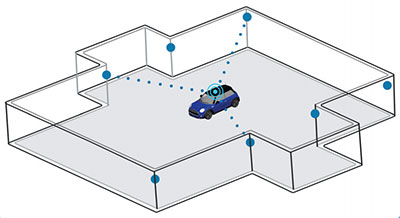
VBOX indoor positioning beacon atop a car. (Photo: Racelogic) Racelogic demonstrated a new VBOX solution for accurate position and velocity in the absence of any GNSS signals, such as indoors, at the ION GNSS+ exhibition.
VBOX data acquisition systems are used for measuring the speed and position of a moving vehicle. Based on a range of high-performance GPS receivers, VBOX dataloggers can record high-accuracy GPS speed measurements, distance, acceleration, braking distance, heading, slip angle, lap times, position, cornering forces and more.

VBOX indoor positioning beacon in a bracket. (Photo: Racelogic) The new VBOX Indoor Positioning System consists of a network of fixed beacons communicating with a small receiver mounted on the roof of the vehicle, which is connected to an existing VBOX. The receiver computes its position 100 times a second to around 5 centimeters real-mean-squared (RMS) accuracy. The system can be used on its own or with an internal inertial measurement unit (IMU) to improve the velocity accuracy.
Racelogic engineers worked closely with its VBOX customers to develop a solution that allows the same test equipment and software that has traditionally been limited to outdoor use to be used anywhere that satellites coverage is limited or completely unavailable, such as in a parking garage.
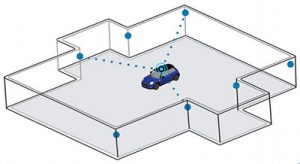
Beacon placement. (Image: Racelogic) The VBOX seamlessly switches between outdoors and indoors, allowing testing to continue whatever the environment and VBOX users to make use of their original hardware and software applications.
Racelogic will demonstrate the system at the ION GNSS+ exhibition at the Hyatt Regency in Miami, Sept. 26-27. Racelogic will also be showcasing its new, upgraded version of SatGen simulation software for the Labsat 3 Wideband simulator.
-
Android, lidar experts to deliver addresses at ION GNSS+

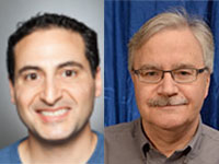
Steve Malkos Steve Malkos of Google, and a GPS World contributor, will address the ION GNSS+ plenary session at the technical meeting and showcase, to be held Sept. 24-28 in Miami.
Malkos will address “Emergency Location Service in Android.” When emergency services get a call, they need to know the caller’s location to send help and save lives. More than 80 percent of calls to emergency services come from mobile phones, but locating these mobile callers can be a major issue.
Current emergency solutions rely on cell tower location (which can have a radius of several kilometers) and, in some countries (like the U.S. and Japan), on A-GNSS. But A-GNSS can fail with weak signal reception, in urban canyons and indoors.
Malkos will discuss how Emergency Location Service in Android is delivering more accurate location (computed from fusion of Wi-Fi, cell, GPS and sensors) to emergency services when an emergency call is detected.

Paul LaRocque Also speaking is Paul E. LaRocque, Teledyne Optech‘s vice president of Special Projects. In his presentation, “A Lidar History: From Ship to Air to Space,” LaRocque will give a historical review of the airborne laser mapping systems that Teledyne Optech has designed and built over the years.
Optech has been active in laser radar systems beginning with marine lidars and later moving to airborne and spaceborne systems. Navigation has been an important subsystem in these developments, and its role will be described as part of this story.
LaRocque has been involved in the development of Optech’s lidar systems since the late 1980s. Dr. LaRocque was instrumental in the design of Optech’s airborne lidar bathymeters, airborne lidar terrain mappers (ALTM), and waveform digitizers, as well as other special lidars.
Both Malkos and LaRocque will speak during Session P: ION GNSS+ Plenary Session on Tuesday, Sept. 25, 6:30-8:30 p.m.
-
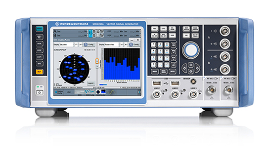
Rohde & Schwarz adds GPS L5 and Galileo E5 to SMW200A GNSS simulator
Rohde & Schwarz has added GPS L5 and Galileo E5 simulation capabilities to its R&S SMW200A GNSS simulator.
The R&S SMW200A GNSS simulator is designed for efficient test and characterization of multi-constellation and multi-frequency GNSS receivers. With its additional simulation capabilities for GPS L5 and Galileo E5, the R&S SMW200A enables generation of complex and highly realistic test scenarios with up to 144 channels in the GNSS frequency bands L1, L2 and L5, the company said.
In addition to GPS (L1/L2/L5), GLONASS (L1/L2), Galileo (E1/E5) and BeiDou (L1/L2), the R&S SMW200A also supports signal generation for QZSS and SBAS on L1. The available channels can be routed to up to four RF outputs, so that even multi-antenna systems can be tested.
Apart from its new GNSS simulation capabilities, the R&S SMW200A can generate complex coexistence and interference scenarios with multiple interferers. GNSS signals, noise and all interference signals are generated directly in the instrument. Additional signal sources for external generation of interference signals are not required, resulting in small, compact and simple test setups.
Launched in 2017, the R&S SMW200A can be turned into a high-end GNSS simulator and is able to internally simulate complex interference environments in parallel with GNSS signals.
An increasing number of GNSS receivers are capable of receiving signals on multiple different frequencies, such as L1, L2 and L5. Although this multi-frequency capability, as well as having to process signals from diverse navigation systems such as GPS, GLONASS, Galileo or BeiDou, make the receiver design more complex, they ensure a better quality of service for the end user.
According to the company, multi-frequency and multi-constellation processing not only improves positioning accuracy, service availability and robustness, it also makes the positioning process less vulnerable to interference, jamming or spoofing attacks.
The R&S SMW200A with its new GNSS simulation capabilities will be showcased at the ION GNSS+ 2018 trade show in Miami.
-

ION JNC early bird registration deadline is June 15
The Institute of Navigation’s (ION’s) Joint Navigation Conference (JNC) 2018 early bird registration deadline is Friday, June 15.The JNC, sponsored by the Military Division of the Institute of Navigation, will be held July 9-11 in a U.S. only, For Official Use Only (FOUO) environment at the Hyatt Regency Long Beach in Long Beach, California. The U.S.-only classified sessions will be held July 12 at The Aerospace Corporation.
According to ION, early registration can save $200 on conference registration fees by entering a reservation confirmation number from the Hyatt Regency Long Beach at the start of the registration process. Attendees will need a valid hotel confirmation number to claim the discount during registration.
Registration can be completed here.
Attendance Restricted
Conference attendance for both FOUO U.S. only (July 9-11) and U.S.-only classified sessions (July 12) will be screened by the Joint Navigation Warfare Center and will be restricted to U.S. only.
Admission to the classified session will be limited to the capacity of the room and will be allocated on a first-come, first-served basis, to those who submitted visit requests in advance. Attendees requiring onsite security validation will be processed on a space-available basis. You are encouraged to submit your visit request early.
-
PNT Roundup: Columbus discovers — and implements — smart city solutions

Image: NXP USA Columbus, Ohio, has positioned itself smartly for an autonomous future, taking a lead role in pilot projects on infrastructure and autonomous air and road transport.
The city will draw on up to $40 million in grants from the U.S. Department of Transportation, $10 million from Vulcan, Inc,. and $500 million in local private pledges.
Carla Bailo, assistant vice president for mobility research and business development at Ohio State University (OSU), presented the city’s ambitious program at ION GNSS+.
In “Position, Navigation and Timing — An Enabling Technology for Mobility and Smart Cities,” she focused on a triple-zero target: zero accidents and fatalities, zero carbon footprint and zero stress.
Smart Columbus will put six autonomous shuttle buses in the commercial district, coordinate truck platooning, time deliveries and manage parking to reduce congestion, and undertake drone delivery of medical supplies and other critical needs. Multimodal transit apps, mobility assistance for those with disabilities and pedestrian collision avoidance will be based on real-time data on transit options and availability, as well as traffic information, road and weather conditions.
Position, navigation and timing (PNT) technologies play a central role in smart cities: vehicle-to-vehicle and vehicle-to-infrastructure communication, autonomous navigation and collision avoidance, location-based services and smart, resilient infrastructure.
Smart Columbus envisions the city as a center for high-tech transportation research and innovation. OSU’s partnerships with mobility companies and vehicle manufacturers, industry groups and government agencies contribute to the city’s comprehensive approach to the smart city project. Through its expertise in sensors, communication, PNT, transportation, autonomous and connected vehicles, and geospatial science and engineering, OSU will serve as the lead researcher on Smart Columbus.
Dorota Grejner-Brzezinska, OSU professor and frequent contributor to GPS World, in her new role as associate dean for research at OSU’s College of Engineering will be a key participant in research projects on ways to integrate self-driving cars, deliver high-definition 3D maps and metadata, use sensors to better connect vehicles for safety and efficiency, and find better ways to move people around the city when they don’t have access to a car.
-
Live from ION GNSS+ 2017
The GPS World staff is reporting live from ION GNSS+ Sept. 25-29 in Portland, Oregon, providing news, photos, videos and more. GPS World will be there with a full team, including Editor-in-Chief and Publisher Alan Cameron, Managing Editor Tracy Cozzens and Digital Media Manager Joelle Harms.
We will be providing coverage of the show on GPSworld.com, Facebook and Twitter.
Take a look at the full show program.
VIDEO PLAYLIST
NEWS
What to expect from ION GNSS+ and Intergeo 2017
ION GNSS+ includes other sensors, offers new short courses
Skydel’s latest SDX release features new jamming option
-
ION GNSS+ Twitter contest
Headed to ION GNSS+ 2017?
Tweet a selfie with @GPSWorld Group Publisher and Editor-in-Chief Alan Cameron OR in the GPS World booth at ION GNSS+ and you will be entered to win two tickets to the GPS World Leadership Dinner!
To qualify, simply tweet a selfie with @gpseditor Alan Cameron, or in the GPS World booth, tag @GPSWorld and use #iFoundAlan. One winner will be randomly selected at 1 p.m. on Thursday, Sept. 28, and contacted via direct message on Twitter. Photo must be taken at ION GNSS+ 2017 and submitted prior to noon on Sept. 28.

-

GPS World staff travels to industry’s largest trade shows
In Portland, Oregon, and in Berlin, Germany, the two largest and most important international conferences on GPS, GNSS, PNT, survey, mapping and geodesy take place this year on exactly the same dates — just 5,177 miles apart. Now that’s bad timing. Our strategy is to divide our forces and send key personnel to interact with industry leaders at each gathering — to bring you the news and developing stories you need to keep on the forefront of change.
If you’re at ION GNSS+ or Intergeo, look for these faces, come up and introduce yourselves. We want to talk with you! If you’re not fortunate enough to attend either conference, look to our website, newsletters and this magazine for product launches, videos and in-depth stories filed from the developing frontiers of PNT. We’ll be reporting !!Live!! and for weeks, even months, to come.
Attending Intergeo in Berlin:

Burch
Barwacz
Joyce
GerardTim Burch is our survey editor; in his day job he’s a professional surveyor and board of directors secretary of that profession’s national society.
Allison Barwacz is digital media content producer for North Coast Media (NCM, that’s us) with a passion for videography and writing.
Mike Joyce and Ryan Gerard, senior account manager and account manager, respectively, work closely with our marketing partners, who make this magazine and multi-media communications channel possible.
Attending ION GNSS+ in Portland:

Stoltman
Whitford
Mitchell
Cozzens
Harms
Sabau
Limpert
Cameron
LangleyKevin Stoltman is founder and president of NCM, with a distinguished career in business-to-business publishing.
Marty Whitford is editorial director and publisher; earlier, he actually worked at GPS World and attended ION-GNSS 2004.
Michelle Mitchell is account manager for GPS World and senior marketing and event manager for NCM. She knows the GPS industry landscape and players extremely well.
Tracy Cozzens is our managing editor, with her hands on all the controls.
Joelle Harms is an award-winning digital media manager, focused on content planning and creation.
Joe Sabau is an account manager with a keen eye for market trends.
Kelly Limpert is a digital media content producer developing a strong online and social media presence for all of our partners.
Richard Langley is GPS World’s innovation editor and a professor at the University of New Brunswick.
And myself. All together, we are your A-team!