Skydel Solutions has released SDX Release 17.8, which offers a host of improvements, according to the company. The 17.8 release offers an advanced jamming feature, as well as improvements for Gaussian noise, spectrum view and the graphical user interface (GUI).
The new advanced jamming option provides unique interference testing capabilities for SDX users. It leverages the power of the GPU/SDR combo to create a new way to simulate interferences, enabling transmitter trajectories and user-defined waveform creation.
Skydel Solutions will be exhibiting at ION GNSS+ in Portland, Oregon, in booth #100. Attendees can learn about the new system and watch a demonstration of SDX’s latest features. Also, Skydel’s Iurie Ilie will host a technical session about spoofing on Friday, Sept. 29, at the conference.
With SDX’s Advanced Jamming package, users can:
Create user-defined waveforms. Chirp, CW, BOC, AWGN, BPSK and pulse interference modulation are supported and can be combined at will to create custom, complex interference waveforms.
Create multiple real-time jammers. Users can create a single or multiple jammer transmitters with user-defined waveforms. Up to 100 interferences can be generated in real time.
Add dynamics to transmitters. Users can create more realistic jammers for simulations; SDX’s dynamic jammers can change position relative to the receiver as the simulation progresses. Their power levels are defined from the transmitter’s point of view. During the simulation, SDX automatically calculates the resulting signal at the receiver antenna in real-time and takes into account the transmitter antenna pattern, the propagation loss and the receiver antenna pattern. The transmitter, like the simulated receiver, has six degrees of freedom. Furthermore, the trajectory may even be defined in real-time using the hardware-in-the-loop API.
It’s almost September. For the GPS World staff, this means scramble time. We have two important industry events to attend: The venerable ION GNSS+ conference and the huge Intergeo trade show.
ION GNSS+ is the Institute of Navigation’s largest technical meeting and showcase of GNSS technology, products and services. Hundreds of papers are shared by experts in the field, in presentations and panels.
The show has changed over the years to broaden its focus to applications, and added a “+” to its name to incorporate all the positioning, navigation and timing (PNT) technology that aids GNSS in location, much as we have also done in providing a new subtitle to our magazine.
New this year are Short Courses, aimed at bringing your non-technical staff up to speed on the technology behind the industry, no matter their background. For instance, one course is “GNSS 101: An Introduction.”
Intergeo, which is held each year in different city in Germany, comes to Berlin. The huge show, attended by about 17,000 people, is a conference and trade fair (emphasis on trade fair) for the fields of geodesy, spatial data, surveying, UAVs and land management.
A hot topic at Intergeo continues to be Geospatial 4.0, the massive transformation where big data, mobility and cloud solutions are driving a new global digital economy.
Other buzzed-about topics include photogrammetry, building information modeling (BIM) and smart cities.
One important and timely topic is the need for infrastructure that ensures data security and protection. Once again, the Interaerial Solutions show for UAVs will take place as part of Intergeo.
Companies and organizations like Spirent Federal Systems share their products and insights in the exhibit hall. (Photo: ION)
The ION GNSS+ 2017 conference and industry exhibition covers all aspects of satellite navigation technology. It takes place Sept. 25–29 at the Oregon Convention Center in Portland.
The theme this year is “GNSS + Other Sensors in Today’s Marketplace.”
The conference will feature two tracks:
“Applications and Advances” focuses on safety of life, commercial and mass-market applications, and GNSS plans and policies.
The second track, “Research and Innovations,” will concentrate on autonomous systems, multi-sensor applications and advanced GNSS algorithms.
Short Courses taught by Internationally Recognized Leaders
This year, ION is introducing complimentary Short Courses to be taught by internationally recognized GNSS experts and educators throughout the day on Monday, Sept. 25.
Short Courses are designed to enhance the ION GNSS+ attendee experience while giving everyone an opportunity to learn from the rock stars in the field, according to ION’s Executive Director, Lisa Beaty.
Presented in a lecture-style learning environment, the Short Courses are designed for professionals at any level of their career, for engineers and academics as well as the non-engineer wanting to boost their knowledge base in a particular area (such as members of the sales team).
The Short Courses will taught by internationally recognized GNSS experts and educators. These instructors are masters in their field, the people who developed the technology and “wrote the textbooks.”
The Short Courses are complimentary to all registered ION GNSS+ 17 attendees.
Courses include:
GNSS 101: An Introduction
Fundamentals of GNSS Receiver Design
Precise Time and Time Interval (PTTI) Services from GPS and GNSS Systems
Image-Aided Navigation
Assisted GNSS (A-GNSS)
Resilient Position Navigation and Time
A Practical Introduction to GNSS/INS Integration
Nonlinear Estimation Techniques for Navigation Systems
Kalman Filter Applications to Integrated Navigation 1 and 2, James L. Farrell / Frank van Graas
Introduction to Multi-Constellation GNSS Signals, John Betz
Raw GNSS Measurements from Android Phones: Theory and Application, Wyatt Riley / Steve Malkos / Mohammed Khider
GNSS Error Characterization, Analysis and Mitigation, Chris Bartone
Plenary Session: Sept. 26, 6:30–8:30 p.m.
Featuring Stan Honey, yacht racing navigator, Emmy-winning developer of TV graphics, engineer in navigation and remote sensing.
Also featuring Carla Bailo, assistant vice president for Mobility Research and Business Development, The Ohio State University, speaking on smart mobility, smart cities and the importance of GIS in the Internet of Things.
A team of researchers at the University of California, Riverside has developed a highly reliable and accurate navigation system that exploits existing environmental signals such as cellular and Wi-Fi, rather than GPS.
The technology can be used as a standalone alternative to GPS, or complement current GPS-based systems to enable highly reliable, consistent, and tamper-proof navigation. The technology could be used to develop navigation systems that meet the stringent requirements of fully autonomous vehicles, such as driverless cars and unmanned drones.
Led by Zak Kassas, assistant professor of electrical and computer engineering in UCR’s Bourns College of Engineering, the team presented its research at the 2016 Institute of Navigation Global Navigation Satellite System Conference (ION GNSS+), in Portland, Ore., in September. The two studies, “Signals of Opportunity Aided Inertial Navigation” and “Performance Characterization of Positioning in LTE Systems,” both won best paper presentation awards.
Most navigation systems in cars and portable electronics use the space-based GNSS. For precision technologies, such as aerospace and missiles, navigation systems typically combine GPS with a high-quality on-board inertial navigation system (INS), which delivers a high level of short-term accuracy but eventually drifts when it loses touch with external signals.
Despite advances in this technology, current GPS/INS systems will not meet the demands of future autonomous vehicles for several reasons: First, GPS signals alone are extremely weak and unusable in certain environments like deep canyons; second, GPS signals are susceptible to intentional and unintentional jamming and interference; and third, civilian GPS signals are unencrypted, unauthenticated and specified in publicly available documents, making them spoofable. Current trends in autonomous vehicle navigation systems therefore rely not only on GPS/INS, but a suite of other sensor-based technologies such as cameras, lasers and sonar.
“By adding more and more sensors, researchers are throwing ‘everything but the kitchen sink’ to prepare autonomous vehicle navigation systems for the inevitable scenario that GPS signals become unavailable. We took a different approach, which is to exploit signals that are already out there in the environment,” Kassas said.
The plenary talk by John O’Keefe at ION GNSS+ stimulated a lot of neuron firing inside this old noggin. For a synopsis of “The Positioning System of the Brain,” see this column by Managing Editor Tracy Cozzens. I had the difficult task of following this brilliant scientist to the podium and introducing ION’s track chairs for previews of the conference’s technical content. Here’s how I attempted to stitch together the two parts of the evening program.
Dr. O’Keefe’s talk called two things powerfully to my mind. The first is us, here, now. In the Oregon Convention Center, where we have gathered four times before. How do we remember its hallways, spaces, electronic stairways? What will direct us to technical sessions over the next three days? Our neural system enables us to orient within an environment, to navigate from one place to another and to remember spatial information. I’ve always struggled to understand aspects and workings of memory. Now to find that place is a key driver, that’s powerful.
The second thing it called to mind is a book I read forty years ago, that has lingered with me since. In Cheyenne Autumn, Mari Sandoz evokes the Native American precursive sense of place. Both past and future exist simultaneously in the present. When the nomadic tribe on their annual migration cycle rode to their summer hunting grounds or through their autumn passages, the events in their past that took place in those areas became very much alive in their awareness. And the figures from their history spoke to them and rode with them through the sandhills, ravines and river crossings of Nebraska and Wyoming.
In their tragic 1878 outbreak for freedom, the Cheyenne eluded the technological might of the U.S. Army sent to intercept them. They did so through their multisensory connection, through memory, to place and direction. Though ultimately defeated, they left us a legacy, an awareness, a state of mind to nurture: understanding memory — with place. And understanding place — with memory.
O’Keefe (left). Grid cells form networks with the place cells in the hippocampus, a circuitry that creates a comprehensive positioning system — an inner GPS — in the brain.(Source: Nobel Committee)
The Institute of Navigation Satellite Division looked deeply inward for its keynote speaker at this year’s ION GNSS+ conference, held Sept. 12–16 in Portland, Oregon.
Nobel Laureate John O’Keefe provided insight into how our brains determine position. In 1971, O’Keefe recorded signals from individual nerve cells in the hippocampus of rats roaming about a room. He found that a type of nerve cell in the hippocampus was always activated when a rat was at a certain place, and other nerve cells were activated when the rat was at other places.
O’Keefe concluded that these “place cells” formed a map of the room. The place cells were not just registering visual input, but building an inner map of the environment. The hippocampus generates numerous maps, which can be seen by the activity of place cells activated in different environments. The memory of an environment can be stored as a specific combination of place-cell activities in the hippocampus.
In 2005, co-laureates May-Britt and Edvard Moser discovered another key component of the brain’s positioning system. “Grid cells” generate a coordinate system and allow for precise positioning and pathfinding. Their research showed how place and grid cells make it possible for rats — and presumably us — to find our way around, determining where we are in the world and which way to go.
Recent investigations show that place and grid cells also exist in humans. In patients with Alzheimer’s disease, the hippocampus is frequently affected, causing those afflicted to lose their way. Knowledge about the brain’s positioning system may help us understand the mechanism underpinning the disease.
Back again in Portland, Oregon, the 2016 Institute of Navigation’s ION GNSS+ conference was a great opportunity for the GNSS community to catch up on what’s been cooking in the industry, and of course who’s been doing what in the research community.
The attendees eagerly took to a wide range of technical paper presentation sessions, and from time to time came to take a look at what industry had to offer on the exhibit floor. Lots of engaging research reports, from work undertaken over the last year by academia, again drew a significant number of attendees from around the world.
On the other hand, industry continued the trend to go to trade shows in application sectors and pull back somewhat from ION GNSS+ as a place to look for product sales. So the number of companies on the ION show floor remained around the same or maybe a little less than in the previous few years. Nevertheless, the quality of the companies exhibiting remained high and there were some interesting newcomers.
A number of major GNSS receiver manufactures have pulled back from ION, so there were only two established U.S. companies and two new U.S. entrants at the show. On the other hand, GNSS simulation companies were at ION in force — eight all told, or twice as many as the receiver manufacturers present who have been their historic customers. But the trend in GNSS simulation now appears to be to move down stream towards the needs of integrators and systems outfits — in segments such as automotive, UAV and agriculture — with lower cost, very capable simulators.
Receiver makers roll out new tech
As a consequence, the NovAtel and Septentrio booths got a lot of attendee traffic, while BDStar (Unicore receivers and Harxon antennas) and ComNav also had a number of visitors to their booths. As usual, NavTech, who represent almost all the manufacturers, also had a busy exhibit.
OEM7600 dual-frequency receiver.
NovAtel chose to launch its OEM-7 series of GNSS receivers and a newly designed VEXXIS high-precision antenna at ION GNSS+, which is a somewhat refreshing return to the ION GNSS+ launch platform we used to see in the past. A new highly integrated ASIC at the heart of this receiver now provides, amongst other features, 555 channels, L-band support, inertial SPAN capability and an intriguing “Interference Toolbox”. The toolbox enables integrators to localize interference effects over a wide band — especially helpful for densely packed electronics, which you might expect in a UAV, for instance.
Interference Toolbox Screenshot.
Septentrio didn’t have a whole lot of new product announcements, but as usual the company has been working hard at improving existing capabilities on its receivers. The AsteRx4 receiver that uses a new ASIC has been available for a while, but it too boasts 544 channels — perhaps too many to actually be used in practice — robust heading, centimeter-level RTK and decimeter-level PPP (with TerraStar and Veripos corrections) with dual L-band channels, and an improved suite of advanced interference mitigation (AIM+) capabilities. This helps detection and removal of the effects of “chirp jamming” from low-power “cigarette-lighter” jammers — using signal analysis and adjustment of adaptive notch filters.
Septentrio did announce a new PolaRx5TR packaged time-and-frequency transfer receiver and a contract with the Jet Propulsion Laboratory (JPL) for reference stations and timing. A report by UNAVCO also found its way into my inbox, which related comparative testing of the PolaRx5 and other manufacturers’ receivers in connection with a UNAVCO RFP – Septentrio did O.K. and was selected as a preferred vendor, which no doubt influenced the JPL award and added to an already good first half year for the company.
The Septentrio PolaRX5TR.
BDStar had a range of GPS, GLONASS, Beidou receivers from its subsidiary Unicorecomm, along with an impressive selection of antennas from Harxon, another of its Chinese subsidiaries. Both product lines have done very well in the Chinese market, and BDStar would like to sell more in North America.
ComNav also displayed a similar range of GNSS receivers and antennas, with new versions of both since last year, and a strong desire to break through into the US market.
Simulators a big presence
Simulator companies at ION included the more established Spirent, Spectracom, CAST, IFEN and Rohde & Schwarz — we could even now consider RaceLogic/LabSat as a record-and-playback fixture in the market. But in the wings and making lots of waves at the show were Syntony from France and Skydel from Montreal, Canada.
Spirent brought its usual large-scale GNSS simulators to ION, but also featured an interference detection and software analysis suite, a 16-bit high-fidelity record/playback unit, along with a new multi-frequency simulator aimed at downstream integrators. The GSS200D Detector finds interference effects and is able to relate them to the threats in the environment around a receiver. The object is to help debug an installation by finding internal interferers. The analysis tools can also help differentiate between regular equipment interference and potential external jammers.
Spirent’s new GSS200D detector.
Spirent also displayed a record/playback unit that has 16-bit playback capability, enabling a user to record and review a particular interference event, and then feed their new commercial simulator in order to replicate the interference. So a passing isolated jamming event can be analyzed in detail. Multiple reruns are possible to confirm the effect on the target system, and following equipment modifications, prove that the problem has indeed been neutralized.
Spirent analysis tools.
RaceLogic introduced its new wideband LabSat 3 record/playback system for GPS L1, GLONASS L1, Galileo E1, BeiDou B1, QZSS and SBAS. Recording live signals for any or all of these signals then allows later playback of a canned sample for equipment debugging on the bench. The LabSat product line has been around for some time, and this addition increases the debug capability for downstream users at an affordable price in a very portable format. When used with the RaceLogic SatGen software system, the user has access to a powerful toolset for testing new GNSS devices.
LabSat 3 and SatGen test set-up.
Spectrcom displayed its multi-frequency, multi-constellation simulator and also featured a GNSS vulnerability test system for interference detection and system debugging. The company’s approach requires two simulators, both synchronized by an atomic clock, allowing a PC-based Test Scenario Control to generate reproducible interference effects for debugging.
CAST Navigation is already moving downstream quite quickly with its CAST-SGX handheld GNSS simulator. With a touchscreen display, this simplified L1 GPS simulator (with P-code option) is ideal for test-bench debugging.
Rohde & Schwarz had its usual array of high-end test equipment, with a test set-up aimed at demonstrating testing of a Wi-Fi indoor location application on a smartphone.
IFEN showed up with a completely re-engineered simulator with huge frequency/channel capacity. The Titan GNSS Simulator houses up to 8 RFSIM modules, each of which carries 32 configurable satellite signals. A fully configured Titan chassis can therefore provide 256 channels of GPS L1/L2/L5, GLONASS G1/G2/G3, Galileo E1/E5/E6, Beidou B1/B2/B3, IRNSS L5 and S-band, QZSS L1/L2/L5/LEX and all current L1/L5 SBAS signals. Titan also has up to four independent RF outputs.
IFEN Titan GNSS Simulator.
Skydel is one of the newcomers in GNSS simulation, but has made significant inroads first appearing last year at ION. Skydel now boasts a full-up, reconfigurable GPS, GLONASS, Galileo, Beidou “software” simulator which the company claims to sell at a 1/3 the price of a conventional hardware simulator. And during the year, Skydel teamed up with Talen-X in Ohio, who have embedded Skydel software-defined in a U.S.-sourced GPS/GLONASS/Galileo/Beidou simulator that can include GPS P/Y and M-code.
Broadsim from Talen-X powered by Skydel.
Syntony rises high by going under (the ground)
The noise in simulation at ION was, however, created by Syntony from Toulouse in France. Syntony recently won a 15-simulator order from OneWeb — the outfit that plans to launch a 640 internet connectivity satellite constellation through 2020. With funding secured from Virgin Group and Qualcomm in 2015, initial satellite build is underway at Airbus Defence and Space, launch services are contracted with Arianespace to provide 21 multi-sat launches on Soyuz beginning in 2017 with optional launch service with Virgin Galactic. So Syntony is likely going to be able to build, deliver and be paid for its 15 simulators, which will be used for testing GPS capability that is integrated into each comms satellite.
Syntony’s simulator is also software-defined and is reconfigurable. The software-defined heart of this system comes from a Syntony GPS/Galileo receiver, and a version of this receiver has now been sold for use in the Airbus Adeline re-usable space module. This receiver is a “multi-antenna receiver” in order to avoid signal or tracking loss while switching between antennas during the Safran launcher rotation. The catch here is that Syntony must develop this receiver to Airbus critical airborne software=qualification standards — no mean feat! Syntony is also providing a version of its Constellator simulator for testing this multi-antenna input receiver.
An ECHO record/playback system is also available, which includes high-fidelity 16-bit RF outputs.
Finally, Syntony was able to capture a proof-of-concept location infrastructure project for Stockholm, Sweden’s, underground metro. The metro stations are pretty deep underground, as they have been dug under the sea in and around Stockholm, and no one had been able to come up with a system that would enable emergency 911 calls with associated essential localized position information to be carried from within the stations. Syntony was able to provide a GPS-like signal infrastructure at the stations which is compatible with GPS-enabled smartphones. It worked well, and Syntony verified that there was no radiation of the signal outside any of the entrances to the test station — so no GPS interference. It actually worked so well that Syntony got the contract to equip all 50 metro stations in Stockholm, and the Syntony is now working to spread its system around the metros of all major cities, worldwide.
Defining the Galileo PRS signal…
Then I came across Fraunhofer towards the end of the show, and their posters about a Galileo PRS (Public Regulated Service) receiver. Now, we know that there has been significant discussion between the different security services of countries across the European Union, and its taken a lot of time to get to a definition of the PRS signal and who has access. So it wasn’t surprising that there was no hardware on the Fraunhofer booth; what’s surprising is that there was any mention of such a receiver being available and telling attendees at a conference in the U.S. that it’s available.
I talked to a couple of people at their booth, and indeed there is such a receiver, but they really couldn’t tell me anything about it because telling is strictly verboten! Another strange anomaly of the Galileo program — the participants seem to want to let the U.S. know that they have the capability for a special access service, and a receiver is available to work with it, but they can’t tell us anything about it. I guess the idea may be to rattle the cage of the U.S. P-code/M-code guys, and let them know Galileo has caught up at last… But Fraunhofer has an idea of how to make things available to, well, err …. to somebody. They have a concept to have cellphone users who want PRS to connect with their cloud receiver, and they will decode and provide PRS position back over the internet. That solves the whole security thing…. OK, that should do it.
Where inertial stands
I also made the rounds of the inertial and inertial/GPS guys at the show, and there were quite a few. From NorthropGrumman and Systron Donner and their mil-spec high-end FOG and RLG and Quartz MEMS tube-shaped inertial units — could they be for shells or missiles? — to Silicon Sensing’s MEMS accels and gyros and their move out of automotive and towards high-precision performance, to Sensonor’s high-performance commercial MEMS/GNSS units, there were actually only a few of the inertial-aiding outfits present. Yet everything we hear is that for anything that moves, we really should use integrated inertial/GNSS, and UAVs especially want lots of that! So this part of the business looks to be quite healthy too…
Now another ION GNSS+ conference has come and gone — and I was reminded that maybe I’ve actually been to 95 percent of the ION September conferences over the last 30 years. And as I write, the last of the late Friday paper sessions are crawling to a close.
ION still remains a good place to come and learn, a place to meet industry colleagues and a place to see a little of what industry is up to. Definitely worth the trip, and don’t forget your business cards next year.
To save on registration rates for ION GNSS+ 2016, the 29th annual meeting of the Institute of Navigation Satellite Division, complete your early bird registration by Friday, Aug. 12.
If you book your hotel room for ION GNSS+ 2016 before you register, you will receive $200 off your conference registration. To qualify for the discount, enter your hotel confirmation number from the Hilton Portland & Executive Tower, The Quality Inn Downtown Convention Center or the Courtyard by Marriott Portland Downtown/Convention Center at the start of the registration process. You will need your valid hotel confirmation from one of these official ION GNSS+ hotels to claim the discount during registration.
Keynote Address: The Positioning System of the Brain
Join Professor John O’Keefe, winner of the Nobel Prize in Physiology and Medicine for the discovery of cells that constitute a positioning system in the brain, as he explains how animals and humans find their way and the “cognitive map” that forms the framework for identifying where you are, where other things are in your environment and how to get from one place to another.
30th Anniversary Celebration
Celebrate 30 years of ION GPS, ION GNSS and ION GNSS+ with a 1980’s style celebration, featuring the decade’s best food, games and music. 1980’s dress is encouraged; raffle tickets for prizes will be given to those who attend in costume. This event is included with all registrations.
It’s funny sometimes how things work out. I had just been preparing to take up in this column an issue raised last September at the ION-GNSS+ Plenary Session. Literally at the very moment I set pen to paper, notice of an extremely positive response to the problem arrived in my inbox. Hypercoincidental as it may be, market forces can and do work in mysterious ways, inexorably driving forward progress.
The issue arose during “lightning talks” as track chairs gave brief overviews of material to be presented in the following days. That’s when Paul McBurney tackled the gorillas.
A former eRide co-founder and now CEO of GopherHush Corp., a location analytics company, he chaired the Mass Market Application track. As he described market players — GNSS chip providers, sensor providers, indoor location providers, app providers and operating system (OS) providers — he made this statement: “The OS providers are the 800-pound gorillas that we have a hard time getting into this room. They have to support their fusion layers over a wide range of handsets and devices. They often end up competing with the apps makers they enable.”
A couple of those gorillas were in the room, in fact, and at least one more prominent GNSS figure has since joined their band. We’re talking Google and Apple, in case you hadn’t guessed.
McBurney’s point, as he later elaborated to me: “The OS manufacturers are really driving/owning the requirements/feature set of the mass-market chip providers. If they wanted carrier phase to drive RTK in the OS, everyone would have to step up to provide it, and these chip makers would lose their advantage in providing that to higher paying customers. If chip makers aren’t able to play, they are relegated to the crumbs of the rest of the market. Even car navigation is barely 1/10th of mobile. OS providers also dictate where/how sensor fusion/indoor location is performed. Sensor chip providers are in the same boat.”
I’d been thinking on and off about this situation since September, and as said was about to trumpet a call for the gorillas to come down out of the mist — or wherever they reside — to collaboratively and constructively join the PNT community. That’s when this message popped in through the electronic transom:
“Google I/O was this week and we announced we will open pseudoranges (raw GPS measurements) to application developers. If you want, I can do a blog post for you on this for the next magazine.”
Well, you bet I do! Look for it in the July issue. This is big news indeed. Check the website for a bit of elaboration in the meantime, and for the link to a YouTube video of the Google I/O announcement.
McBurney has further thoughts on this development, and you’ll see some of those next month as well. For now, he opines, “I was thinking that Google opening up pseudoranges shows that, while they wield huge power, they still understand the advantage of being open. A clear distinction from Apple.”
A first-time gathering at ION GNSS+ gives mentors in the GNSS field an opportunity to help newcomers.
By Tracy Cozzens
Managing Editor
I had the privilege of attending a unique and special gathering at ION GNSS+ this past September. The meet-and-greet event was Women in PNT, sponsored by the Institute of Navigation (ION), Spirent Federal Systems and NovAtel.
“The idea to organize it cropped up last January in discussions with several ION colleagues, men and women, who recognize that both academia and industry in the navigation-related fields may not be considered as an attractive career path for young female professionals, due to insufficient mentorship and too few role models,” explained organizer Dorota Grejner-Brzezinska, who is ION president, a professor at The Ohio State University and contributor to GPS World. “The main goal of this, and future gatherings, is to show the younger women in PNT that balancing engineering or academic career with family life is quite possible, and that there are many of us out there who can mentor, advise and help.”
The guests were treated to a variety of delicious hors d’oeuvres shared with champagne, and plenty of time to get acquainted and network. But the highlight of the event was the stories and perspectives shared by the eight designated mentors, who discussed the tricky business of balancing home life and work life, including motherhood, despite building a career in a challenging male-dominated field.
More than 60 women attended the event. “I didn’t even realize we had that many ladies in the PNT community,” said Grace Gao, assistant professor, University of Illinois at Urbana-Champaign.
“I hope that the younger women were able to network and take away some of the advice and wisdom provided,” said Francine Vannicola, mathematician, U.S. Naval Research Laboratory.
A poll conducted after the event showed that all attendees are likely to attend another such gathering, and everyone found it not only satisfactory, but valuable. One attendee commented, “I was trying to make a time sensitive career decision, and it was extremely helpful to discuss it with people who fully understand the field but have absolutely no involvement in the outcome. Their feedback was valuable and unbiased.”
The mentors also found the networking opportunity invaluable. “I got to talk to several fellow PNT women whom I would probably not have met in, say, the exhibition hall,” said Anna Jensen, professor, KTH Royal Institute of Technology. “Also, it was encouraging and motivating to hear the stories from the other panelists.”
“As I entered into engineering school, I felt a great deal of competition between the men and women,” said Ellen Hall, president, Spirent Federal Systems. “I felt it in the workplace, also. But at the women’s PNT event, it seemed like a support group where all guard could be let down, and everyone genuinely wanted to help one another.”
“As a young woman I often discounted specific women in science or engineering events because I didn’t think they were necessary and that I already knew how to run with the boys,” said Sandy Kennedy, director and chief engineer, NovAtel. “Now that I am older, I see the value in them because we do have specific challenges to face. And as a hiring manager, I also value these events to meet students and new grads.”
“I think this is a great event that brings women together not to be judged by their papers and presentations,” said Jade Morton, professor, Colorado State University. “Instead, we were all in the same room to support each other, and to share our own struggles and triumph. That was wonderful!”
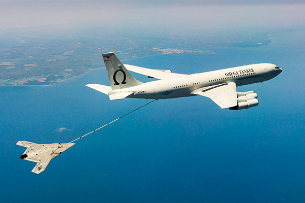
The X-47B unmanned combat aircraft receives fuel from an Omega K-707 tanker on April 22 while operating in the Atlantic Test Ranges over the Chesapeake Bay. This test marked the first time an unmanned aircraft refueled in flight. The X-47B is a tailless, jet-powered, blended-wing-body aircraft capable of semi-autonomous operation and aerial refueling.
STOIC Technology to Augment or Substitute for GPS
The Defense Advanced Research Projects Agency (DARPA) selected Rockwell Collins to develop technologies that could serve as a backup to GPS. The research, being conducted as part of DARPA’s Spatial, Temporal and Orientation Information in Contested Environments (STOIC) program, aims to reduce warfighter dependence on GPS for modern military operations.
Rockwell Collins will develop new architectures and techniques to enable communication systems that will support time transfer and positioning between moving platforms independent of GPS, with no impact on primary communications functionality.
“STOIC technology could augment GPS, or it may act as a substitute for GPS in contested environments where GPS is degraded or denied,” said John Borghese, vice president of the Rockwell Collins Advanced Technology Center. “The time-transfer and ranging capabilities we are developing seek to enable distributed platforms to cooperatively locate targets, employ jamming in a surgical fashion, and serve as a backup to GPS for relative navigation.”
Borghese added that the goal of the STOIC program is to develop positioning, navigation and timing (PNT) systems that provide GPS-independent PNT, achieving timing that surpasses GPS levels of performance. The program is comprised of three primary elements that, when integrated, have the potential to provide global PNT independent of GPS, including long-range robust reference signals, ultra-stable tactical clocks, and multifunctional systems that provide PNT information among cooperative users in contested environments.
For this third technical element, Rockwell Collins is tasked with developing multifunction communication system solutions that yield DARPA STOIC objective picosecond-accurate time transfer and enable GPS levels of relative positioning accuracy in contested environments.
“Future applications of STOIC technology could include a variety of precision relative navigation operations, such as autonomous aerial refueling and cooperative navigation and collision avoidance within unmanned aerial vehicle swarms,” Borghese said. “It also could support precise time transfer for networking operations in contested environments.”
ELORAN
Wildwood eLoran Tests Continue
The Wildwood, N.J.,eLoran 100-kHz transmitter continuously broadcast a signal from 0900 (EDT) on Oct. 20 through 1800 on Oct. 22, with plans to transmit further eLoran test signals from 0900 (EST) on Nov. 3 until 1200 on Nov. 6, and again from 0900 on Nov. 9 until1500 on Nov. 13.
The purpose of these tests is to gather data on differential Loran performance in the Boston Metro and D.C. Metro areas. “Besides fixed eLoran receivers at our N. Billerica, Mass., and Leesburg, Va., offices, we also have additional fixed eLoran receivers located at the USNO and at the Harris Corporation offices in Herndon, Va.,” stated UrsaNav. The company also plans to gather temporal and spatial decorrelation data in both Metro areas. Note that these signals are for test purposes only and should not be used for any other purpose.
In May, Exelis, UrsaNav, the Department of Homeland Security’s Science and Technology Directorate (DHS S&T) and the U.S. Coast Guard entered into a cooperative research and development agreement (CRADA) for testing and demonstration at former Loran-C sites, including Wildwood. The team will evaluate eLoran as a potential complementary system to GPS.
The sites are the legacy ground-based radio navigation infrastructure of the decommissioned Loran-C service that could be retained and upgraded to provide eLoran low-frequency service.The broadcasts will provide a usable signal at a range up to 1,000 miles.
INERTIAL
MEMS Perspective on SatNav Gathering
By Alissa M. Fitzgerald
In September, I attended the Institute of Navigation GNSS+ 2015 conference, where I chaired a technical session on commercial
micro-electro-mechanical sensors (MEMS). As the founder of a MEMS product development firm, I was eager to gain perspective from the world’s largest technical meeting and showcase of satnav technology, products and services.
Overall, the navigation community is enthusiastic about integrating MEMS into navigation systems. They like the idea of getting more data from small, relatively low-cost sensors. Recently, U.S. Secretary of Defense Ashton Carter declared his wish that we move to MEMS-based position, navigation and timing (PNT) information.
What navigators want from MEMS depends on who they are.
The “high integrity” navigators — the people whose systems land airplanes or steer self-driving cars — would like MEMS sensors with enough performance to enable accurate inertial navigation without GPS for at least 10 minutes. If a GPS receiver can’t see at least four satellites in the sky, it can’t produce accurate navigation data. High integrity navigators are the original developers of sensor fusion systems; they know that no one sensor is perfect, so they design systems to detect loss of a reliable signal, and then adeptly switch between sensor data streams as needed to maintain accurate navigation information. Ten minutes of GPS-independent inertial navigation buys you enough time to get to higher altitudes, out of a tunnel or around a skyscraper, to a position that improves your view of the sky.
The “consumer” navigators — the people who want you to help them find the nearest Starbucks in downtown San Francisco — would like better low-cost MEMS gyroscopes and magnetometers, specifically with improved stability, to improve pedestrian inertial navigation. Although pedestrians are relatively slow-moving compared to vehicles, a key challenge to their accurate navigation is maintaining inertial position fixes while their smartphones unexpectedly change orientation: waving about in a person’s hand or sliding around in a purse or pants pocket.
It’s clear we MEMS people need to spend more time with these end-users, to first understand how MEMS will integrate with their other sensors and GNSS, and then to derive the essential MEMS sensor specifications for each specific navigation system and use case. The quest for seamless navigation has been and will continue to be an exercise in sensor fusion.
Alissa Fitzgerald is managing member, A.M. Fitzgerald & Associates, a MEMS consulting firm serving diverse industries.
The Averna RP-6100 Multi-Channel RF Record & Playback for RF application testing allows users to tecord real-world signals such as GNSS, HD Radio, LTE and Wi-Fi — plus impairments — to significantly advance projects and harden product designs. Skydel Solutions’ GNSS simulator is an entirely software driven innovative and cost-effective simulator that works with the RP-6100, enabling users to test corner cases and future events with a real-time GNSS solution.
PCTEL’s GPS/GLONASS high-performance asset tracking and synchronization helix antennas are now available commercially. The antennas capture the frequencies needed for GPS, Galileo and GLONASS satellite reception. This cross-compatibility allows global OEMs to use one standard platform to serve both European and U.S. markets.
PCTEL uses its proprietary filtering design to allow wideband coverage while achieving superior out-of-band rejection. With an IP67 rating, the small form-factor helix antennas will withstand harsh environments.
AsteRx-U and AsteRx-U Marine multi-constellation dual-antenna receivers incorporate the latest GNSS tracking and positioning algorithms and interference mitigation. Machine-control users in the agricultural, construction, marine and mining industries benefit from a complete system with integrated UHF radio, Wi-Fi, USB, Bluetooth and cellular connectivity and a spectrum analyzer. All configurations can be done via the on-board web interface.
The AsteRx-U has decimeter- and centimeter-level RTK positioning including TerraStar. The AsteRx-U Marine also supports Veripos PPP augmentation services.
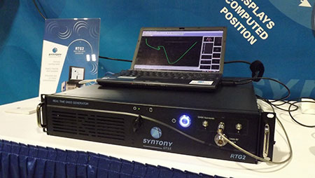
The RTG2 is a GNSS constellation simulator that generates realistic GNSS RF signals, taking into account current and future GNSS constellations. RTG2 is able to entirely simulate one or many constellations (GPS, Galileo, etc.) including satellite-based augmentation systems such as WAAS and EGNOS.
The generator is entirely configurable (troposphere and ionosphere effects, simulated receiver trajectory, etc.) through a user-friendly interface accessible on a separate PC through Ethernet. RTG2 is highly flexible and scalable, offering hardware and software upgrades for capability extensions.
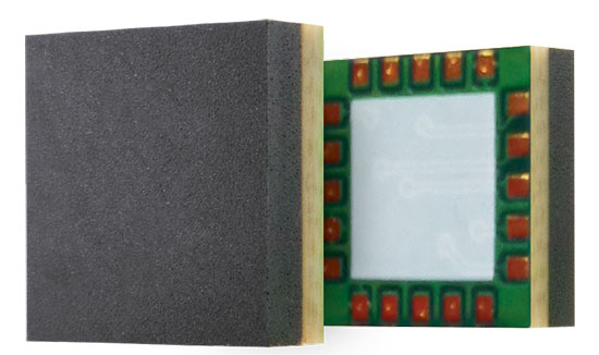
Telit’s Jupiter SE873 GNSS receiver with flash memory.
GNSS Receiver with Flash Memory
The Jupiter SE873 GNSS receiver is a complete multi-constellation position, velocity and time engine that delivers versatile performance in harsh environments. The 7 x 7 x 1.85 mm module has serial quad I/O flash memory, an integrated low noise amplifier, SAW filter, TXCO and real-time clock. The Jupiter SE873 supports Assisted GPS (both autonomous and server-based) plus SBAS, which improve time-to-first-fix and position accuracy. AGPS data is stored in flash memory and is available even after all power has been removed and then restored. This is especially important for battery-operated equipment.
The SE873 supports the entire GNSS spectrum: GPS, GLONASS and BeiDou, and it is Galileo ready. It delivers simultaneous low-power tracking of GPS and GLONASS or GPS and BeiDou.


 It’s funny sometimes how things work out. I had just been preparing to take up in this column an issue raised last September at the ION-GNSS+ Plenary Session. Literally at the very moment I set pen to paper, notice of an extremely positive response to the problem arrived in my inbox. Hypercoincidental as it may be, market forces can and do work in mysterious ways, inexorably driving forward progress.