Symmetricom will be participating in a new products panel at ION GNSS+, which will be held September 16-20 in Nashville, Tennessee.
Phil Bourekas, Symmetricom executive vice president of marketing, will take part in “New Products Panel: Legacy and Expertise in GNSS Timing” on Thursday, September 19, 8:30 a.m. to 12:15 p.m. in Grand Ballroom East of the Nashville Convention Center, Nashville, Tennessee.
The presentation will focus on Symmetricom’s suite of GNSS-applicable timing products, ranging from precision time protocols to atomic clocks, and how they can be used by the government, communications, power and enterprise verticals.
Symmetricom is also a sponsor of the exhibitor-hosted reception. In its booth (#619), Symmetricom will exhibit and demonstrate the following products:
GPS Time & Frequency Receivers (XLi and XLi SAASM GB-GRAM models)
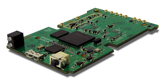
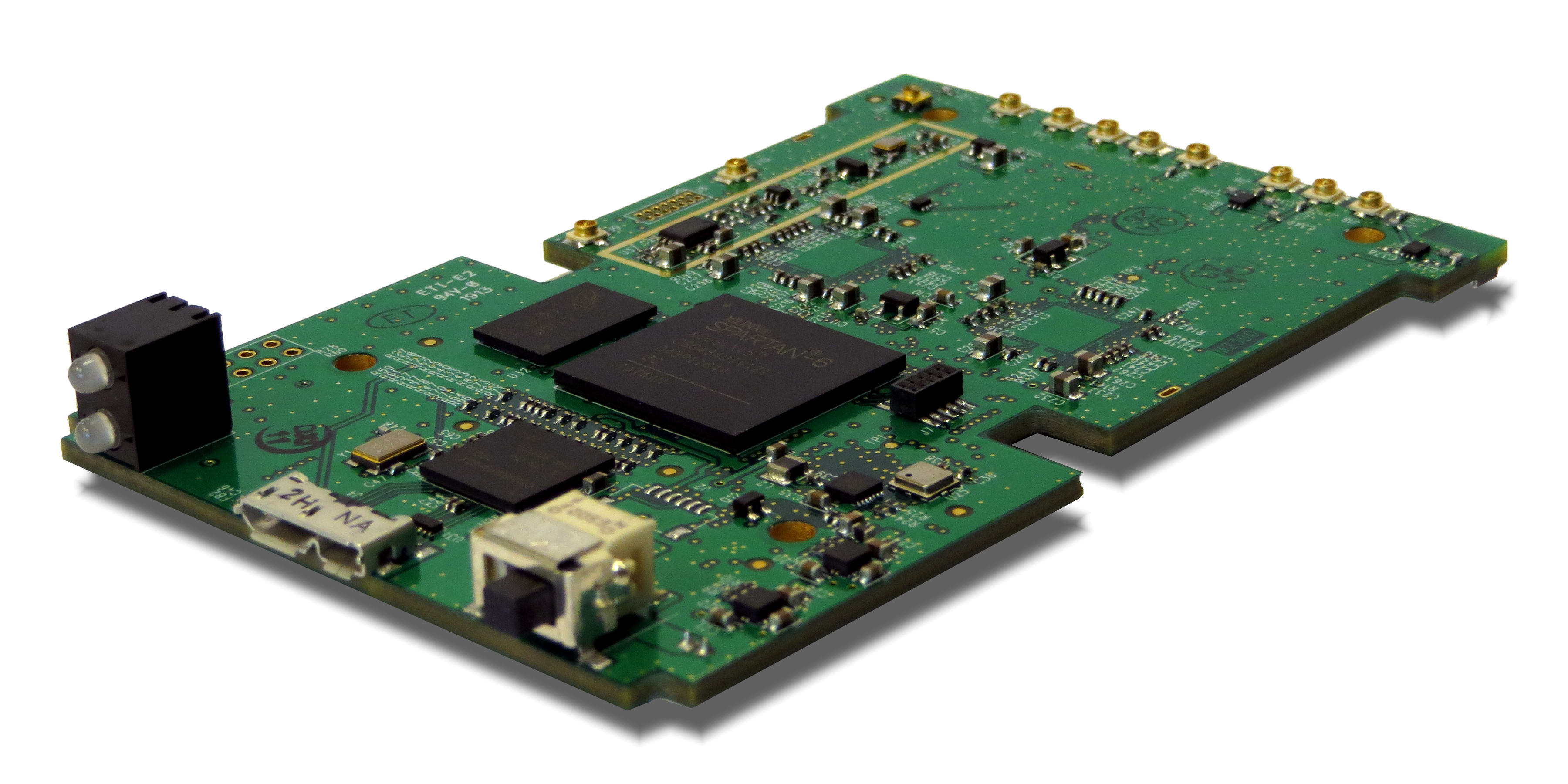
Loctronix Corporation, a provider of unified positioning solutions for GNSS-challenged environments, is making available its new software-defined radio (SDR) module, the ASR-2300, for developing high-performance positioning, navigation and timing, and communication applications.
The ASR-2300 will be on display September 16-19 at the Institute of Navigation annual meeting, ION GNSS+ 2013, in Nashville, Tennessee.
“The ASR-2300 delivers advanced SDR capabilities in a small, mobile form-factor enabling developers to readily create and field complex SDR-based solutions. The module moves SDR out of the lab and into production, providing the critical piece for tapping advanced, multi-sensor/signals of opportunity for high-performance PNT,” stated Michael Mathews, Loctronix’ CEO and founder.
According to Mathews, “The ASR-2300 is unique amongst the growing number of SDRs, having multiple, fully-integrated RF paths supporting reception of GNSS, cellular, ISM band, and UHF signals of opportunity. The ASR-2300 will benefit SDR developers working on demanding scientific, military, aerospace and commercial/industrial applications.”
The ASR-2300 is a multiple-input and multiple-output (MIMO) transceiver module incorporating two wideband Field Programmable RF (FPRF) transceivers (300 MHz to 3.8 GHz) from Lime Microsystems, 10-axis accelerometer/gyro/compass/barometer sensors, and a large programmable FPGA capable of over 300 MiB/sec sustained communications with a host processor via USB 3.0 interface. The module’s nine integrated RF path options and low size, weight, and power characteristics contribute to ease of integration and portability. Accommodating both internal 1 PPM TCXO or external frequency reference, multiple ASR-2300s can be inter-connected via an expansion port and/or UART interface, supporting real-time reception / transmission of 4, 6, 8 or more signals without the need for significant additional hardware.
With on-board flash for storing developer customizable firmware and FPGA logic, the ASR-2300 can be configured to operate in a variety of different power profiles, maximizing battery life without requiring a host processor. The modules will be factory-programmed with only the RF receiver capabilities enabled. Developers can enable transmit functionality by modifying the firmware and waveforms.
The A2300 Open Source Project at Myriad RF
To encourage innovation in PNT and communications applications, Loctronix has partnered with Lime Microsystems to provide the source materials for the ASR-2300 module under open source licensing at the Myriad RF project.
“The broad utility of the ASR-2300 makes it an ideal platform for prototyping and developing advanced applications in the communications and PNT markets. Developers can make their own boards using the documents and design database contained in the A2300 project and/or purchase hardware, development kits, support services, and licensed waveforms directly from Loctronix,” Mathews said.
“Encouraging collaboration between the open source community and industry is a natural way to promote innovation and accelerate growth of SDR technology. We are delighted to partner with Loctronix to make their innovative ASR-2300 SDR design available to open source developers for creating advanced SDR applications,” said Lime Microsystems CEO Ebrahim Bushehri, Ph.D.
The open-source software package includes basic drivers for Linux and Windows environments enabling both GNU Radio and embedded C/C++ developers to interface with the ASR-2300 module. Developers can obtain source code and design documents for modifying the ASR-2300 to suit their own applications.
The ASR-2300 will be available from Loctronix this November. Adaptors, antennas, and a housing kit will also be available that provide a variety of configuration options supporting bench-top testing to wearable, battery-operated field demonstrations.
The 53rd meeting of the Civil GPS Service Interface Committee will be held Monday and Tuesday, September 16-17, before the Institute of Navigation GNSS+ 2013 Conference. Both events take place at the Nashville Convention Center, in Nashville, Tennessee.
Monday morning’s CGSIC concurrent sessions include the Timing Subcommittee and the Surveying, Mapping, and Geosciences Subcommittee. Monday afternoon’s sessions include the International Information Subcommittee and the U.S. States and Local Government Subcommittee.
Navtech is offering a four-day version of Course 551, “Using Advanced GPS/GNSS Signals and Systems,” customized for those attending the ION GNSS+ 2013 conference.
This course will help attendees develop proficiency with advanced receiver processing of current, modernized, and new signals from GPS, GLONASS, Galileo, BeiDou, and QZSS. It teaches systems engineering skills, along with techniques for receiver processing and for assessing processing performance. Review problems, worked in class, help students understand and apply the key concepts.
Those who attend will become proficient with the essential aspects of using GPS and GNSS signals.
Course days:
Friday, Saturday, September 13-14
Monday, Tuesday, September 16-17
The Institute of Navigation’s (ION’s) advance program for the 2013 GNSS+ conference in September arrived in the mail the other day, and was avidly consumed. The technical sessions of this gathering are prime hunting ground for presentations that later become articles in this magazine, as are, to lesser extent, those of the European Navigation Conference, the Joint Navigation Conference, CTIA, ITS World Congress, and others.
Something struck me as I scanned the 280-odd presentations listed under 36 session tracks: the frequency with which the word BeiDou appeared. To determine if there were any substance to this fleeting impression, I essayed a quantitative analysis. Naturally, GPS and the generic GNSS occurred times beyond measure, but this is how the others fared.
What does this signify? Little enough, possibly. Still, something. A satellite navigation system bursts seemingly out of nowhere and within a few short years virtually laps the field, putting 20 (14 usable) transmitters into space and establishing a regional operating capability, soon to be global. That sort of thing tends to get noticed.
The titles of BeiDou-focused papers on tap this fall in Nashville — not all of them springing from the laptops of Chinese engineers, not by a long shot — add substance to this passing fancy.
◾ BeiDou Consumer Receiver Chips at Last.
◾ A Combined GPS/BeiDou Vector Tracking Algorithm for Ultra-tightly Coupled Navigation Systems.
◾ Towards the Inclusion of Galileo and BeiDou/Compass Satellites in Trimble CenterPoint RTX.
◾ New Assisted BeiDou Products from JPL’s Global Differential GPS System.
◾ BeiDou Integration in Cell Phones and Tablets.
◾ BeiDou — A System That is Now Ready for Applications.
◾ Augmenting GPS RTK with Regional BeiDou in North America.
◾ New Systems, New Signals, New Positions — Providing BeiDou Integration.
The affiliations of some of the authors of the above read like a top-level directory of North American and European GNSS manufacturers. Clearly, the ground has been plowed and the fields lie ready — if they are not already planted. Unless that’s too mixed a metaphor for satellite radionavigation signals.
The recent acquisition of one Western GNSS manufacturer by a major Chinese business concern has not gone unnoticed, either.
For more intelligence, I consulted the newest member of this magazine’s Editorial Advisory Board. He replied to my emailed penny for his thoughts.
“I would be happy to contribute a column for the July issue based on my observations here at the China Satellite Navigation Conference in Wuhan. The article would be titled: Little Tigers versus Wolves.”
Here is the accuracy and estimation game played by 208 guests at GPS World’s Leadership Dinner in Nashville, Tennessee, on Thursday evening, September 20. Take a gander at the rules that follow, and then try your skill at the nine questions.
To play fair, do not use Google or any other research, reference, or resource. Dinner guests were honor-bound not to employ their smartphones — just their smarts. You are, too.
The first six questions had known answers (at least to the gamesmasters) at the time of the dinner. The final three peered into the future, as of that evening. Two of them have since been determined. Once the Galileo question is settled, the What Do You Know Grand Winners — 10 individuals who sat and gamed together among the 21 competing tables — will be announced, and suitable tchotchkes distributed.
A special division for online contestants has been established; send your answers to [email protected]. Any entries that are too suspiciously close to the true answers will be disqualified for use of unauthorized resources.
The accounting and awarding — and all the answers — will appear on the Wide Awake Blog in the very near future. Do not touch that dial.
Game Rules
1. What Do You Know? What’s Your CEP? consists of nine quantitative questions. Answer each question as best you can — without the aid of outside sources! Then give your error range: an upper bound and a lower bound.
Answers will be graded on how close they are to the true answer, the size of the error range given, and whether that error range encompasses the true answer. The smaller your error range, the higher your potential score — but if the true answer falls outside your error range, you score zero for that question.
2. The second and third rules pertained to “play by tables” at the dinner, and are irrelevant and thus omitted here.
4. A final trifecta of three questions asks you to predict events in the future. After turning in your answers to these questions, game play concludes for the evening. A final Grand Prize to the winning table will be awarded after the last event.
A more detailed mathematical explanation of the scoring process is available at the scorer’s table, should you wish to see it.
And now, are you ready to play . . . .
What Do You Know??!!??!! What’s Your CEP??!!??
1. Estimate the distance in kilometers from Shanghai, China, to Nashville, Tennessee, along a Great Circle global route, and from that derive the number of Delta II booster rockets (used to launch GPS satellites) laid end-to-end that would cover that distance.
Upper bound ______________
Absolute answer _________
Lower bound ______________
2. Give the total area, in either square inches or square centimeters (specify which you are giving) of a rather substantial hat worn by Kate Middleton, Duchess of Cambridge, to a friend’s wedding in July of this year.
Kate Middleton
That hat!
Upper bound ______________
Absolute answer __________
Lower bound ______________
3. Peg the number of total orbiting and operating GNSS satellites, including SBAS, as of September 20, 2012.
Upper bound ______________
Absolute answer _____________
Lower bound ______________
4. Jack Daniel’s, a sour mash whiskey made in Lynchburg, Tennessee and the best-selling whiskey in the world, is known for its square bottles and black label. How many shots of whiskey does a white-oak barrel of Jack Daniel’s contain?
Jack Daniel’s barrel in the Hermitage Hotel, Nashville
Upper bound ______________
Absolute answer _____________
Lower bound ______________
5. How many of Richard Langley’s “Innovation” columns have appeared in GPS World magazine?
Upper bound ______________
Absolute answer _____________
Lower bound ______________
6. In his memoirs, Tony Blair mentions that, when he first met Queen Elizabeth II as Prime Minister of the UK, the Queen put him in his place by telling him, “You are my tenth prime minister. The first was Winston. That was before you were born.”
In a similar vein, how many individuals have served as Prime Minister (official, not acting or deputy) of Japan from the beginning of the Shōwa era under Emperor Hirohito in 1926 until today? (Note: This is the count of individual persons. A single person serving as Prime Minister several times, such as the postwar Prime Minister Shigeru Yoshida, counts only once.)
Upper bound ______________
Absolute answer _____________
Lower bound ______________
Final Trifecta
7. Predict the number of days that will elapse between the day of the combined launch of the Galileo IOV-3 and IOV-4 satellites and the day when the first satellite of that pair is declared operational. Dates are defined based on UTC. For example, if the launch should take place on the currently scheduled date of October 10, then October 11 would be 1 day, October 31 would be 21 days, and so on. If the launch occurs on a different date, we start counting from there.
Upper bound ______________
Absolute answer _____________
Lower bound ______________
8. Predict the number of U.S. states, out of 50, that go blue in the Presidential election on November 6, 2012 — that is, their electoral votes go to President Obama’s Democratic Party ticket.
Upper bound ______________
Absolute answer _____________
Lower bound ______________
9. Predict the total number of combined points scored in all three NFL football games to be played on Thanksgiving, November 22: Houston Texans vs. Detroit Lions, Dallas Cowboys vs. Washington Redskins, New England Patriots vs. New York Jets.
There were a lot of the familiar faces at the Institute of Navigation GNSS 2012 convention in Nashville September 18-21. The show activity level was around the same as last year with a few more companies exhibiting. The format of workshops/panel discussions has really helped make program updates more comprehensible and accessible, but there weren’t a large number of technical/product papers by manufacturers.
The global panel discussions/workshops were popular, providing constellation status overviews on GPS, GLONASS, Galileo, and Compass/Beidou, as were the SBAS updates on the European EGNOS, US WAAS, and Russian SDCM. We also heard of key EGNOS and WAAS L5 implementation plans.
The exhibit hall was somewhat busy, with several new companies attending, and there were new products around if you looked for them, even if some had already been announced prior to ION. Manufacturers now have a number of market-segment product showcase shows where they can pitch new applications and products, so they don’t always save these for ION. ION still presents the opportunity for international industry/agencies/academics to get together and meet face-to-face, and this is still a key ingredient that pulls people in. Nashville this year was as ever a great venue — you could almost hear the music on Broadway from the exhibit hall.
Some snippets of news I collected during the show included:
Russia is still moving forward with next-generation GLONASS capability plans, and build-out of the System for Differential Corrections and Monitoring (SDCM) — the Russian SBAS. With one Luch GEO already on orbit, recovery is well underway to replace an apparent recent launch failure of the second Luch GEO, and the ground network continues to grow with 19 reference sites inside Russia and five outside. The Russian space industry is apparently undergoing a phase of consolidation, with fewer stronger organizations emerging. Plans for a new generation of SDCM multi-constellation reference receivers — including use of GPS, Galileo and other SBAS signals — are apparently being considered.
EGNOS in Europe is also moving right along, rolling out GNSS aircraft approaches, mostly in Germany and France, with LPV precision approach development well advanced in France, Germany and UK. Thirty-seven ground reference sites are up and running with step-by-step improvements in accuracy, integrity and coverage planned out to at around 2014/2016.
U.S. WAAS now has virtually 10 years of operational experience, with 38 ground reference stations and three operational GEOs. The FAA said that WAAS is achieving 99 percent availability over the continental U.S., and good service coverage extends well into South America and up into Alaska and Canada. Phase IV WAAS during 2014-2028 will see the change-over from use of L2 to L5 for measuring and generating ionospheric corrections, and a new GEO is planned for procurement around 2015-2018. Almost 2,000 LPV precision approaches have been commissioned at 1,900 U.S. airports — +60,000 aviation users appear to be largely general aviation and to some extent scheduled airlines. The FAA is targeting expansion of the number of approaches by 2016 to more than 5,000.
Beidou has aspirations to provide “sole-means” navigation capability in Western China where nothing else currently exists, and with 17 ground reference sites hopes that CAT I approaches could be supported.
Todd Walter of Stanford University is working with the FAA, preparing for definition of the service to be provided by the coming L1/L5 dual-frequency GEOs — a long and winding road through pending RTCA committee discussions — but Todd had some good proposals to eliminate redundant data and achieve high-integrity aviation navigation when L5 SBAS service comes on line. The FAA needs industry to look at these proposals and provide feedback so that L5 WAAS signal definition is available for when they want to get their L1/L5 GEOs procured, developed and online.
Photo: Boeing
The third GPS IIF satellite with L5 was launched October 4 and is undergoing on-orbit check-out.
That’s where we have a problem right now, as on-orbit GPS L5 initial operational capability (IOC) was being projected at the show to have slipped all the way out to 2020. So manufacturers are not ready to put resources and money into this effort until some hint of commercial return might be possible. But with GPS dual-frequency L1/L5 being a cornerstone of the FAA’s NextGen, we have to expect that there will be continued pressure to keep launching satellites, that RTCA L5 definition activities will have to move forward, and heck, we should even expect to see people making use of those L5 signals that are available in novel and unexpected ways. Manufacturers who have already taken the plunge and started up L1/L5 receiver development also need specs to be firmed up so they can field these receivers when there is service, so the FAA, Todd, and others need RTCA to move along and industry to support the activity. It would also help to see a firmed-up L5 constellation launch schedule, too.
At the GPS World magazine’s annual Leadership Dinner, held during the ION-GNSS Conference, we gave the first GNSS Leadership Awards to four individuals for their respective work in the four fields of satellites, signals, services, and products. We asked each recipient to give us a vision of the future: upcoming work, whether that’s something they plan to undertake or they think someone else should get going on, new directions for the industry, and so on. We asked them to ruminate as speculatively and as far into the future as they wished to go. Here is what they said.
It had to happen sometime. I just thought or hoped it might take a few more years.
But I guess I should not be surprised since I experienced a wonderful 30-year U.S. Air Force (USAF) career and that has been over for more than a decade. I have been working GPS issues since 1978. So I guess it should not have come as a surprise when just a couple of weeks ago a wet-behind-the-ears USAF 2nd Lieutenant actually inquired of me, in a public GPS-related forum no less, “So, what did you do in the war, granddad?”
Several irreverent and potentially satisfying responses immediately came to mind:
I am not your granddad.
Where do you get off asking me a question in that tone of voice?
Frankly, it is none of your business.
Instead, I simply inquired, “Which one?” This obviously unexpected response necessitated a long pause while the offender, a now obviously-easily-confused 2nd Lieutenant, ruminated about which war(s) to inquire. For my part I was ready to hit him over the head with my cane if he responded with WWII. Of course I would probably have been accused of child abuse, so he saved the day and a possible court date when he replied in a questioning falsetto, “Vietnam?”
I won’t bore you with my response. However, since that unfortunate “age discrimination” incident (from both parties), it has occurred to me that many of us who were privileged to experience GPS in its infancy are certainly not spring chickens. Indeed, many (Dr. Ivan Getting for one) have passed on to their great reward. Remember, Professor (Colonel) USAF Ret. Bradford Parkinson, who created and ran the NAVSTAR GPS Joint Program Office from 1972 to 1978, was a full colonel in 1972. However, that says nothing about commitment or expertise. Most of us, Brad included, are still as engaged and passionate about the future of GPS as we ever were. Consider that the first satellite in the system, Navstar 1, was launched February 22, 1978. In just a few months the GPS operational constellation will be 35 years old, and Air Force Space Command is celebrating its 30th anniversary this year. My point being that few operational space systems, if any, engender this type of lifelong loyalty, passion and dedication. Plus, those of us who count ourselves among the original sojourners on this amazing journey, especially those who are graying and threatening to beat impertinent whippersnappers with canes, are actually very proud of the fact that we are still engaged, and even more amazed and heartened that there’s a generation of young USAF and other military personnel, engineers, scientists, inventors, and everyday believers to follow in our footsteps. I highlight the USAF personnel because they are the official stewards of GPS.
Indeed, at the recent ION GNSS Conference held it Nashville, Tennessee, it was apparent that many of the youngsters (many of whom are Ph.D.s) are just as engaged as we are. They see a future for GPS and PNT (position, navigation and timing) systems that we may never have imagined. As prescient as many of us “seniors” claim to be, I have no doubt, indeed I fervently hope, that the young men and women following in our footsteps will achieve feats with GPS and PNT systems of which we never dared dream.
ION GNSS 2012 – Nashville
I state here without equivocation or worry of being challenged that the plenary at this year’s event, which was titled “GNSS Revolution, the Catalyst of the New Information Age,” was the best I have ever encountered at any ION event in the past twenty years. Dr. Jade Morton from Miami University was an excellent moderator and kept the program moving along, but it was the presenters, their evident, extensible passion for their subjects and their excellent presentations (see list below) that made the night unforgettable:
1.
High Precision Agriculture: Tony Thelen, Director of Intelligent Solutions Group, John Deere
2.
Crime, Punishment, and the Global Positioning System: Professor David Last, Crime Consultant Engineer and Professor Emeritus, University of Bangor, UK
3.
Precision Navigation Sensors Based on Atom Interferometry: Professor Mark Kasevich, Applied Physics, Stanford Universit
GPS and Agriculture
Tony Thelen, the first presenter from John Deere — yes, the people who make green farm and lawn tractors among other things — actually made GPS and agriculture sound interesting. His presentation was top notch. It certainly kept my interest, and he left me wanting to know more about GPS and agriculture! Of course, I am being a bit disingenuous, since one of my most requested columns, titled “The Farmer in Finland,” concerns the unparalleled John Deere StarFire system, which probably deserves another column soon. Conversations with plenary attendees after his excellent presentation indicate that Tony managed to ignite that spark and interest again for many in the audience. The effect that GPS and companies like John Deere have had on agriculture is simply amazing, and the quantifiable benefits almost beyond belief. Plus, according to Tony Thelen, there is good reason to believe we will continue to be astounded at what the future holds for GPS and agriculture. I encourage you to visit the ION website and review not only Tony’s excellent presentation, but all the ION GNSS 2012 Plenary presentations.
GPS Forensics
When you have three excellent and inspiring speakers lined up for an evening of edification, you always face the conundrum of order. Should the featured or most entertaining speaker be in the middle, or should you risk losing some of your audience early and build toward a climax? With this audience Dr. Jade Morton made the wise decision, and put the most anticipated speaker in the middle of the lineup. There is always great expectation on my part, and I expect from most of the audience, when Professor David Last is scheduled to speak. At Nashville, he certainly did not disappoint. Only the infamous tonal chimes from “Law and Order” could have made his presentation any more dramatic.
For my part, I kept expecting to hear those infamous tones whenever David transitioned to a new slide. David’s presentation was a perfect combination of “Law and Order” combined with “The World of Stupid Criminals.” With material like that, how could it have not been a roaring success? Add the dulcet British Public School accent and perfect comic timing and delivery and you can’t fail. Indeed, anyone listening outside the auditorium that night would have thought they had stumbled upon a standup comic convention instead of a bunch of staid scientists and engineers listening to a presentation on GPS forensics.
David is always interesting, but that night he was competing for and in my book won the ION GNSS Emmy. If you ever have the chance to hear Professor David Last speak publicly, don’t miss it. And criminals in the UK should just surrender — they don’t stand a chance in court against a consulting engineer and expert witness like Professor Last. I dare say even Sherlock Holmes, the famous consulting detective, would be proud of Professor Last.
Cold Atom Interferometry
None of this lessens the impact or obvious passion for his subject displayed by Professor Mark Kasevich from Stanford University. It is not that I don’t have a passion for cold atom interferometry, it’s just that two weeks later I am still trying to figure out what he said and how it applies. I have no doubt that you can, excuse me, that Professor Mark Kasevich can, construct a cold atom interferometer that can be used to determine a position or a fix; I am just trying to figure out how that 10-cubic-foot rack is going to fit into anything remotely mobile. But, of course, even the optimistic Professor Kasevich admitted that mobile or handheld atom interferometers of this caliber are probably 10 years in the future.
So, at this years’ ION GNSS Plenary event, the audience was treated to a down-to-earth and yet exciting look at the future of GPS and agriculture: the comedic and yet brilliant GPS forensic expertise of a passionate John Cleese wannabee, a caped crusader who is feared by criminals everywhere, and the futuristic “Star Trek” look at cold atoms and interferometry. What more could you ask for? This was an evening that for me elucidates the best ION GNSS Plenary ever. My hat is off to ION Executive Director Lisa Beaty and Plenary Program Director Dr. Jade Morton for an excellent program, but mostly I applaud all three speakers for a wonderfully educational and entertaining evening. How often do you get to combine those adjectives?
GPS World Leadership Dinner and Annual Awards Ceremony
However, for myself and many others the highlight of the ION GNSS event for the past several years has been the annual GPS World Gala and Dinner, now known as the annual GPS World Leadership Dinner and Awards Ceremony. This wonderful and prestigious event is the brainchild of Alan Cameron, our beloved editor-in-chief and now publisher of GPS World. Every year the event just gets better and better. The venues are always palatial, and this year was no exception as we held the event at the beautiful Nashville Hermitage Hotel. The stained-glass ceiling in the lobby was astounding.
I won’t say much more since Alan wrote a complete review of the evenings events, except to caution you that invitations to this wonderful event are extremely hard to come by, and if you are nice to me, who knows? You might receive an invitation next year. It reminds me of the admonition from my daughter, a PsyD in Psychology and a practicing clinical psychologist, when she says: “You should always be nice to me Dad. Remember, I get to pick your nursing home!”
Kudos and Final Thoughts on ION GNSS 2012
I can’t complete my comments on ION GNSS this year without pointing out that the venue, Nashville or Music City, and the Renaissance Hotel by Marriott were both outstanding. The ambience of the entire event was professional yet also warm and friendly, and the ION staff as well as the staff at the Renaissance could not do enough to make my stay more memorable. The Renaissance staff was extremely professional and attentive, working hard to make the event a success. I am already looking forward to next year’s conference, which will be held at the same location September 16-20, 2013. Book early and arrive early for reasons I elucidate next.
Lest we forget, while the ION GNSS is the main performance, the center ring if you will, it is historically preceded by the Civil GPS Service Interface Committee (CGSIC) meeting, which is co-chaired by the United States Coast Guard (USCG) NAVCEN/CC. The CGSIC has been around for 52 years, and was outstanding this year. Yes, the title sounds incredibly dry and boring, but CGSIC meetings are actually very informative, down to earth, informal and even occasionally entertaining. The new USCG NAVCEN commander, Captain William Burns, and his NAVCEN team did an excellent job putting the event together. So, again, I highly recommend arriving a couple of days early for next year’s ION GNSS in Nashville, so you too can attend the CGSIC. You will find it worthwhile.
LightSquared
As much as I hate to close my column on a downer I must unfortunately inform you that the amnesiacs at LightSquared (LSQ) are at it again. Not exactly the same amnesiacs, of course, as their CEO resigned in February, and Philip Falcone from Harbinger, whose solipsistic behavior resulted in a federal security SEC indictment for fraud, joined the LightSquared board recently. The U.S. Securities and Exchange Commission recently filed securities fraud charges against Falcone and Harbinger Capital Partners. However, this has not slowed LSQ as it subsequently on Septembert 28 submitted two proposed spectrum sharing filings with the FCC, proposing to utilize the lower 5 MHz of LSQ’s non-existent broadband network in a form that was not initially sanctioned or envisioned and, according to the filings, will not interfere with GPS signals. LSQ did not submit any evidence or test data to prove the lack of interference, just conjecture. These filings, of course, are in addition to LSQ’s recent filing for Chapter 11, better known as a bankruptcy filing. Plus, Philip Falcone has publicly alerted the FCC that LightSquared will not go away!
Where have you heard this song and dance before? I have read both filings very carefully, and they are filled with the same flawed technology and total refusal to adhere to the laws of physics as their previous filings. LSQ fails to understand that you cannot abrogate the laws of physics merely because they are inconvenient and interfere with your grand scheme. Previous test results have determined that transmitters as powerful as the ones proposed by LSQ will interfere with GPS signals no matter what portion of the immediately adjacent spectrum bands are proposed.
The latest filings clearly seem to be a last-gasp effort of a dying company that is attempting to snatch victory from the jaws of defeat. LSQ must think the U.S. government has an incredibly short attention span. In my humble opinion, if the FCC were to approve either of the proposed filings, pilots, airlines and passengers at Ronald Reagan National Airport and other major airports on the East Coast would be unable to use GPS to fly out of or navigate to the airports. LSQ continues to think it is more important to be able to tweet, “I just saw Elvis” than it is to navigate safely to your destination. However, as improbable as the acceptance of these LSQ filings may be, in a recent memo I warned my GPS/PNT colleagues, via notable quotes you may recognize, “…unfortunately this is not over, ‘prepare for boarders’ and remember ‘we have not yet begun to fight’.”
GPS II-F 3
Fortunately, I won’t end on a down note after all. As I write this, the third GPS IIF satellite, designated SVN-65, is on orbit being checked out by the 19th SOPS (Space Operations Squadron) with LADO (Launch, Anomaly, and Disposal Operations) software developed by Braxton Technologies. My hat is off to AFSPC (Air Force Space Command), SMC (Space & Missile Systems Center), Boeing, ULA (United Launch Alliance), the 50th Space Wing, and Braxton Technologies for a successful launch and hopefully a quick and flawless checkout. It has been a long 15 months since the last IIF launch, and this is the only launch in calendar and FY12. Plus, technically the satellite on orbit is actually satellite vehicle (SV) four, as SV three is undergoing some necessary changes. Most experts expect a minimum 30-day checkout. However, my sources tell me it could be as long as 90 days. Wouldn’t it be great if it were sooner? We will just have to wait and see. Stay tuned to GPS World for the latest news on GPS IIF-3. The good news is we have another GPS IIF on orbit.
Until next time, happy navigating, and remember all of us at GPS World now have new email addresses in the following format. If you wish to email me please do so at [email protected]. I look forward to your comments.