Tag: IRNSS

  • Inside the box: New NavIC clock outperforms  previous generation

    Inside the box: New NavIC clock outperforms previous generation

    Image: metamorworks/iStock/Getty Images Plus/Getty Images
    Image: metamorworks/iStock/Getty Images Plus/Getty Images

    NVS-01 is the first second-generation satellite of the Indian Navigation Satellite System (IRNSS), also known as Navigation with Indian Constellation (NavIC). It was launched into geostationary orbit on May 20. The satellite is placed at 129.6° eastern longitude and will finally replace IRNSS-1G launched in April 2016.

    Whereas the first-generation satellites transmit navigation signals in the L5- and S-band, NVS-01 is the first IRNSS satellite also transmitting in the L1-band. The 1547.42 MHz frequency is also used by other satellite navigation systems, including GPS, Galileo, and BeiDou-3. However, a different modulation is used, namely a Synthesized Binary Offset Carrier (SBOC) signal. The IRNSS L1 SBOC signal has data and pilot components with and without navigation data. Data and pilot signals consist of BOC (1,1) and BOC (6,1) components with sub-frequencies of 1.023 MHz and 6.138 MHz. A quadrature multiplexing is applied for the data and pilot components with a power sharing of 41.82% and 58.18%. The navigation message on the IRNSS L1 signal has a different structure compared to those on the legacy L5- and S-band signals. The new L1 navigation message uses an advanced frame structure and forward error correction inherited from the CNAV-2 message of the GPS/QZSS L1C signal as well as a similar orbit model. Among other things, it provides inter-signal corrections for the L1 data and pilot signals with reference to the S band signal for single-frequency L1 band users.
    NVS-01 started signal transmission on June 17, 2023, with the pseudo-random noise (PRN) code I10. The satellite’s L1 and L5 signals were tracked by a Septentrio PolaRx5 receiver located in Tokyo, Japan, with a prototype firmware that is capable of tracking the L1 pilot signal. Figure 1 shows the multipath linear combination of NVS-01’s L1 and L5 pilot signals. Whereas the short-term variations are smaller for L1 compared to L5, the overall RMS is 18 cm for both signals.
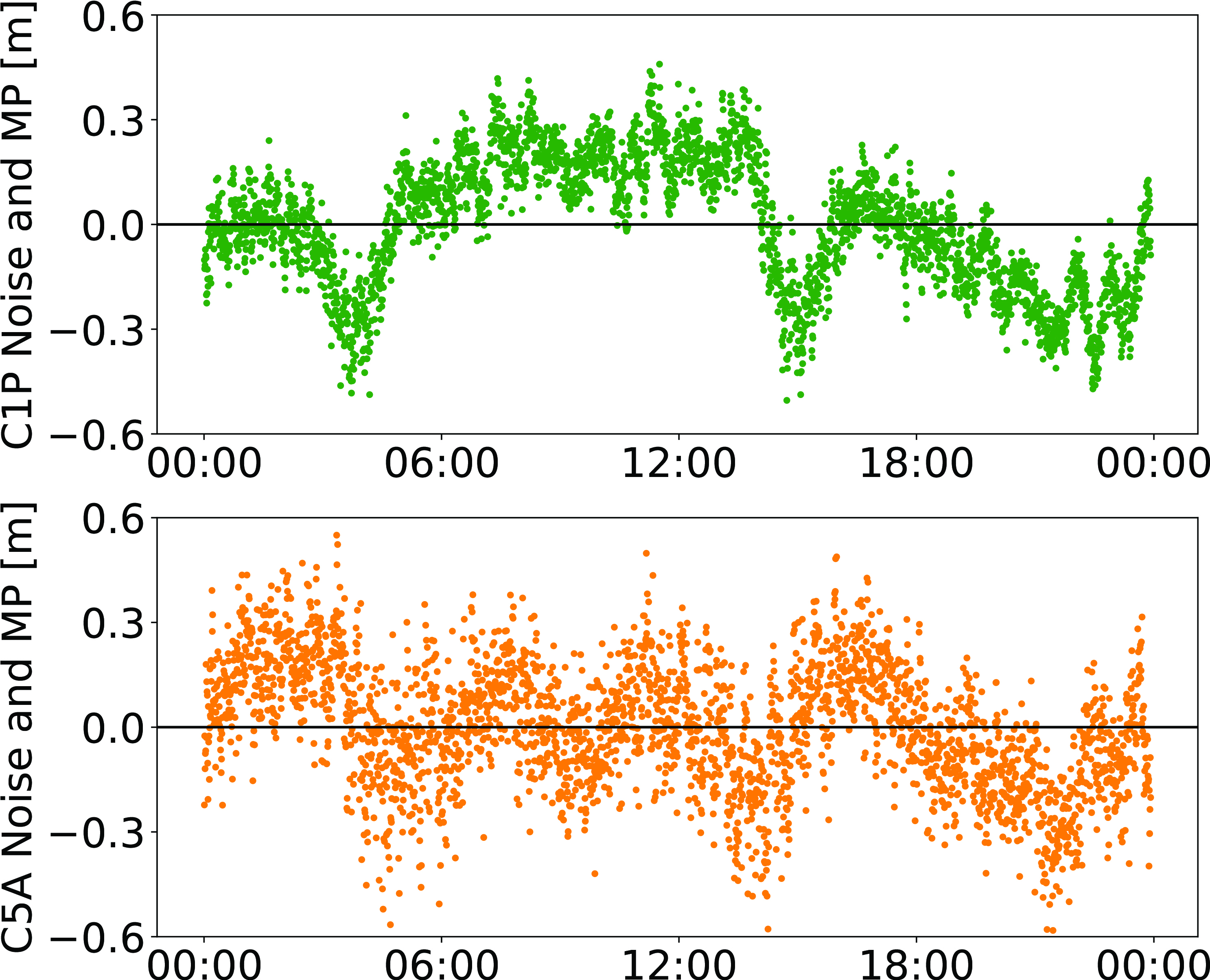
    PFigure 1: Noise- and multipath linear combination for NVS-01’s L1 and L5 pilot signals received on 26 June 2023.
    Figure 1: Noise- and multipath linear combination for NVS-01’s L1 and L5 pilot signals received on 26 June 2023. (Image: All figures provided by the authors) 

    Whereas IRNSS-1’s rubidium clocks were provided by Spectratime, NVS-01 is the first satellite operating a new type of rubidium atomic frequency standard (RAFS) developed in India. The short-term performance of GNSS satellite clocks can be evaluated with the one-way carrier phase method. The receiver is connected to a highly stable external clock, e.g., a hydrogen maser. Thus, the receiver clock error is negligible. Measurement biases as well as the delays of ionosphere and troposphere on short time scales are removed by fitting a fourth-order polynomial. If no external clock is available, as is the case for the station in Tokyo, the precise clock information can be transferred from another station by a reference satellite jointly tracked by both receivers.

    The Allan deviation based on this three-way carrier phase (TWCP) analysis is shown in Figure 2. The hydrogen maser of the IGS station USUD in Usuda, Japan, is used as the reference clock. At short integration times up to 20 s, the Allan deviation computed from the TWCP analysis is dominated by the GNSS measurement noise hiding the true clock performance. Above 20 s, the TWCP demonstrates that the NVS-01’s RAFS stability meets the performance of the ground tests and even exceeds them for longer integration times. At all integration times, the new RAFS outperforms the first generation IRNSS clocks.
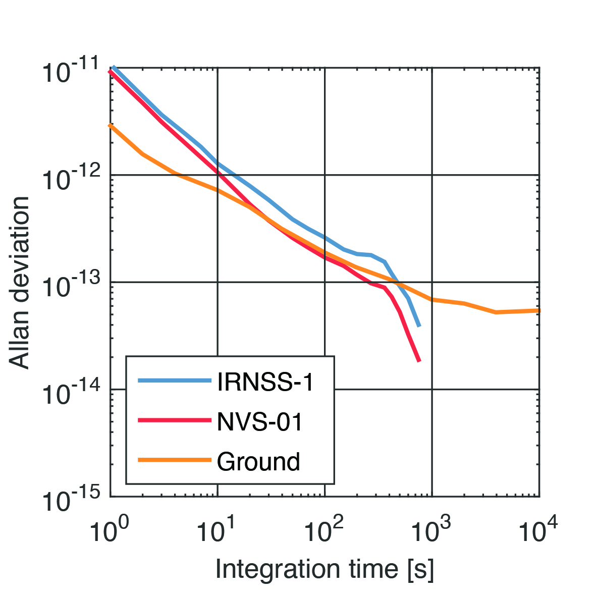
    Figure 2 IRNSS clock performance obtained from three-way carrier phase analysis as well as ground tests.
    Figure 2: IRNSS clock performance obtained from three-way carrier phase analysis as well as ground tests.

    Manufacturers

    GNSS data used in this article were collected with a Septentrio PolaRx5 receiver.

    Further Reading

    Bandi TN, Arora R (2019) Indigenous Atomic Clock and Monitoring Unit for NavIC. ICG-14, https://www.unoosa.org/documents/pdf/icg/2019/icg14/WGD/icg14_wgd_09.pdf

    ISRO (2022) NavIC Signal in Space ICD for Standard Positioning Service in L1 Frequency, Version 1.0. U.R. RAO Satellite Centre, Indian Space Research Organization, Bangalore, https://www.isro.gov.in/media_isro/pdf/SateliteNavigation/Draft_NavIC_SPS_ICD_L1_Oct_2022.pdf


    Peter Steigenberger and Oliver Montenbruck are scientists at the German Space Operations Center of the German Aerospace Center (DLR), where they conduct research in the field of new satellite navigation systems.

    Jean‑Marie Sleewaegen is Lead Architect at Septentrio, Belgium, where he has been responsible for GNSS signal processing, system design and technology development since the company’s inception in 1999.


  • India mandates NavIC support for smartphones, no timeline yet

    India mandates NavIC support for smartphones, no timeline yet

    Photo: MStudioImages/E+/Getty Images
    Photo: MStudioImages/E+/Getty Images

    The Indian government is pushing smartphone makers to sell devices that receive NavIC signals along with GPS.

    India originally stated NavIC would be required in smartphones sold starting in January 2023, according to Reuters, but strong reaction from smartphone manufacturers Apple, Xiaomi and Samsung apparently caused the government to push back or remove the deadline.

    A deadline of January 2023 would not allow enough time for smartphone makers to integrate NavIC-enabled receivers to their devices. Steps include redesign, securing parts, testing and assembly. Many smartphones sold in India by the companies are economy-level devices priced under US$200.

    The three tech giants met with government officials, seeking an extended target date of 2025, Reuters reported.

    However, India’s Ministry of Electronics & IT issued a statement via Twitter :

    India has been pushing for adoption of NavIC since at least 2021, while chipmaker Qualcomm has been producing NavIC-enabled modules since 2020.

    NavIC (Navigation with Indian Constellation) is the operational name for the Indian Regional Navigation Satellite System (IRNSS) developed by India’s space agency for military and commercial purposes. NavIC consists of eight satellites that cover the Indian mainland and the region extending up to 1,500 km from its boundaries.

    “NavIC can help in navigation on land, air, sea and also in disaster management,” Science & Technology Minister Jitendra Singh said in a press release. “NavIC satellites are placed at a higher orbit than the GPS of United States. NavIC satellites are placed in geostationary orbit (GEO) and geosynchronous orbit (GSO) with an altitude of about 36,000 km; GPS satellites are placed in medium earth orbit (MEO) with an altitude of about 20,000 km.”

    “NavIC uses dual-frequency bands, which improves accuracy of dual-frequency receivers by enabling them to correct atmospheric errors through simultaneous use of two frequencies,” Singh said. “It also helps in better reliability and availability because the signal from either frequency can serve the positioning requirement equally well.”

  • GNSS constellations create four strong winds

    GNSS constellations create four strong winds

    Matteo Luccio
    Matteo Luccio

    First, there was one. In July 1995, the U.S. Air Force declared the Global Positioning System had met all the requirements for full operational capability (FOC). Soon thereafter, there were two. In December of that same year, Russia’s Globalnaya Navigazionnaya Sputnikovaya Sistema (Global Navigation Satellite System, or GLONASS), also achieved FOC. For a quarter century, that was it.

    Then, last year, the number doubled, as both the European Union’s Galileo and China’s BeiDou Navigation Satellite System (BDS, named after the Big Dipper asterism, which is known in Chinese as Beidou) achieved FOC.

    The Indian Regional Navigation Satellite System (IRNSS, aka Navigation Indian Constellation, or NavIC, which means “sailor” or “navigator” in Hindi) and Japan’s Quasi-Zenith Satellite System (QZSS, also known as Michibiki) are not global yet, but plan to become so. Currently, NavIC is an autonomous regional satellite navigation system, and NavIC-based trackers are compulsory on commercial vehicles in India. QZSS currently complements GPS to improve coverage in East Asia and Oceania, but Japan plans to have an operational constellation of seven satellites for autonomous capability by 2023. The Korea Positioning System (KPS) plans to join the party by 2035.

    Who’s next? Will it be another country or a private company? Given that the state-sponsored systems are free to end users, I don’t see what the business model would be for a private GNSS constellation, unless it were to piggyback on one built mainly for another purpose.

    Surveyors who have begun to routinely use three or more constellations are over the moon. One, quoted in this month’s cover story, recalls that “the use of GPS for construction staking was an extremely risky proposition” because its residuals exceeded most construction tolerances. Using multiple GNSS constellations, however, has increased confidence in the accuracy of results to the point that some construction companies are relying on GNSS receivers for staking. Additionally, multi-constellation receivers can now increasingly be used under tree canopies and against structures, whether natural or built.

    Whatever their mix of military, political and commercial motivations for building, deploying and operating their own GNSS constellations in addition to the original two, the European Union, China, India, Japan, Korea and whichever entity may follow are greatly improving satellite-based positioning, navigation and timing (PNT) for all users everywhere — by increasing accuracy, shortening the time to first fix, and making GNSS more impervious to jamming and spoofing.

    In 1978, the year that the U.S. Department of Defense launched the first NAVSTAR GPS satellite (“NAVSTAR” was later dropped from the system’s name), Neil Young sang “Four Strong Winds” (originally written by Ian Tyson and performed by him with his wife Sylvia as the Canadian folk-duo Ian and Sylvia).

    Now, GNSS has “four strong winds,” two lighter ones and several more breezes to follow. As a sailor and a navigator, I welcome them heartily. As this magazine’s editor-in-chief, I don’t mind that, like Jeep, Kleenex, Popsicle and Xerox, GPS probably will stick in popular culture as a generic term for global satellite navigation systems way past its accurate description of what is in the box.

    Matteo Luccio | Editor-in-Chief
    [email protected]

  • RX Networks announces NavIC support

    RX Networks announces NavIC support

    Rx Networks logo

    Rx Networks Inc., a mobile location technology and services company, has announced support for the NavIC Constellation.

    The company made the announcement at ION GNSS+, held earlier this month in Miami, Florida.

    Rx Networks’ comprehensive GNSS constellation data service provides technology partners — and their associated customers — real-time and predicted assistance for all satellite navigation systems and L1 satellite-based augmentation systems (SBAS) for any region around the globe.

    The addition of NavIC builds on Rx Networks’ brand promise (to deliver “location enlightened” products and services) by providing real-time and predicted GNSS assistance data in any individual or combination of formats. This enables developers to optimize device performance for specific use cases and conform to national requirements.

    Data is delivered via ephemeris in RINEX and Predictions in SP3, P-GNSS and RT-GNSS, via the Location.io platform, will be added in the first quarter of 2020.

    “Our Location. Enlightened. brand promise speaks to our goal of providing the most comprehensive, relevant, accurate and reliable location data available,” said John Carley, vice president of sales and marketing at Rx Networks. “The addition of NavIC in our carrier-grade infrastructure demonstrates our commitment to our brand and to stay on the leading edge of truly global satellite-based positioning and services. The ability to offer NavIC support is extremely significant as it ensures we can support our customers with exactly what is required in any given region of the Globe.”

    NavIC, formerly known as IRNSS (Indian Regional Navigation Satellite System), combines GEO and IGSO satellites to provide a regional position, navigation and time (PNT) system including ionospheric corrections.

  • NavIC L5 signals now available on NovAtel OEM7 receivers

    NavIC L5 signals now available on NovAtel OEM7 receivers

    photo: NovAtel
    The OEM7 series. (Photo: NovAtel)

    The NavIC Indian constellation is now supported in NovAtel’s latest firmware release for its OEM7 series of GNSS receivers.

    The 7.05.04 firmware release for OEM7 provides the following benefits:

    • Users can achieve a single point position accuracy of 2.5 m (rms) using NavIC L5 signals (from the Indian Regional Navigation Satellite System) with GPS L1 on the newly available JSN model.
    • Access to the L5 frequencies on the OEM7600 and OEM7720 provides triple-frequency capabilities to unlock the potential of GPS L5, Galileo E5a and AltBOC, Beidou B2a and NavIC L5.

    A full listing of all changes in this release are included in the “What’s New” document included in the firmware download package. Visit this page to download the latest firmware for a specific platform. Visit NovAtel’s documentation portal for the OEM7 reference manual.

  • Allystar launches multi-band, multi-GNSS chip for devices

    Allystar launches multi-band, multi-GNSS chip for devices

    Image: Allystar
    Image: Allystar

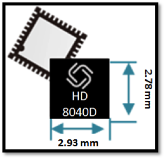
    Allystar Technology Co. Ltd. has launched a multi-band, multi-GNSS system on chip, the HD8040 series, to help portable devices save size and weight. The HD8040 offered in wafer-level chip-scale packaging (WLCSP).

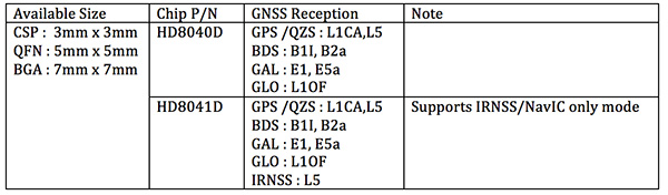
    The HD8040 series of chipsets fully supports all civil signals on the L5 band, said Shi Xian Yang, Allystar high-precision product manager at Allystar. Besides GPS, other constellations with L1/L5 signals include Galileo, BeiDou, the Indian NavIC system and Japanese QZSS.

    Besides L1 band, HD8040D supports L5/B2a/E5a signals, which are expected to have lower noise and be better in multipath mitigation mainly due to the higher chipping rate of L5 signals relative to L1 C/A code.

    HD8041D supports IRNSS (NavIC), which makes it suitable for navigation in urban areas in India and the Middle East, where seven NavIC satellites have a higher elevation than both GPS and Galileo satellites. This means IRNSS (NavIC) would provide greater accuracy, precision and available measurements.

    Chart: Allystar

    With the features of small size (3 x 3 millimeters) and low power consumption, the HD8040 series is suitable for smartphones, tablets and other portable devices.

    The architecture integrates floating-point arithmetic units based on ARM CortexM4, 160 KB RAM, 32 KB backup RAM with VBAT, and 384 KB embedded Flash memory. Besides basic peripheral interfaces UART, I2C, SPI and GPIO, it supports the CAN interface for automotive applications, too.

    Customer samples of the HD8040D and HD8041D are available now.

  • Telit releases NavIC-enabled GNSS module

    Telit releases NavIC-enabled GNSS module

    Photo:

    Telit has introduced a new positioning module aimed at India. The SL869T3-I combines GPS with India’s NavIC (IRNSS) navigation system and the country’s satellite-based augmentation system (SBAS), known as GAGAN.

    The SL869T3-I module enables the creation of high-performance position reporting and navigation solutions. It complies with Automotive Industry Standard 140 (AIS-140) — an Indian government mandate that requires the use of NavIC for vehicle location tracking devices in all public transportation vehicles, effective April 2019.

    The SL869T3-I is a 16 x 12.2-millimeter module with an LLC package. It is provided with a single RF input for L1 and L5 bands. It also contains Flash memory, a low noise amplifier (LNA) and SAW filters. The RF front end is specifically designed to comply with sensitivity specifications contained in AIS-140 standard.

    “The new SL869T3-I is among the first IoT GNSS positioning receiver modules to deliver IRNSS/NavIC L5 coverage compliant with the Indian government’s AIS-140 regulation,” said Manish Watwani, EVP global product management, Telit. “This new addition to the Telit family of products results from more than 20 years’ experience in GNSS applications.”

    For more information, visit booth C3.227 at Electronica, Nov. 13-16 in Munich, Germany.

  • GPS + IRNSS module coming to Indian market

    A new GPS + IRNSS module is being developed by Indian firm Ramakrishna Electro Component (REC) in partnership with STMicroelectronics and Shanghai Mobiletek, according to press reports.

    The module will rely heavily on the Indian navigation satellite constellation IRNSS (also known as NaVIC), REC Managing Director Shivang Luthra told reporters at an event in New Delhi.

    “There have been dependency of imported GPS module which use the U.S., European or Russian satellites,” Luthra said. “We have developed a GPS module, Utraq, that will mainly use the Indian satellites for GPS navigation.”

    The module will be produced at a Shanghai Mobiletek factory in China, and the chips will be made by STMicroelectronics. REC owns the Utraq module and will roll it out  in October for use in automotive end products. REC says the low cost of the chip compared to imports will make trackers more affordable in India.

    The Indian government has mandated use of vehicle location tracking devices and one or more emergency buttons in public transportation vehicles; the mandate took effect April 1.

    Utraq will be offered in two models: the L110 GNSS is a compact NavIC module, while the L100 GNSS module is a smaller-sized (patch on top) IRNSS module. Both modules can be used for tasks other than tracking, such as ranging, command, control and timing, and fo marine, aerial and terrestrial navigation.

  • The benefits of the multi-GNSS future

    Galileo, BeiDou, QZSS, IRNSS, and more join GPS and GLONASS to bring you wider, broader, greater, more accessible and above all more accurate PNT. How to get all that’s coming at you?

    Multi-GNSS paves the way for complete exploitation of new signals and constellations in navigation, surveying, geodesy and remote sensing.

    What exactly are the benefits of multi-GNSS, and how can you access them? For a start, download the multi-GNSS signal schema, and follow that up by attending a free webinar, “Multi-GNSS: Advantages, Challenges and Test Solutions.

    The free 1-hour webinar, which will take place at 1 p.m. Eastern [10 a.m. Pacific,  7 p.m. (1900h) Central European Time] on Thursday, Sept. 20, will review advantages of using multi-GNSS for the end-user and challenges in obtaining maximum efficiency when combining multiple constellations and signals. It will also discuss different approaches of testing GNSS receivers against jamming and spoofing attacks.

    You will learn:

    • Advantages of using multi-GNSS
    • Challenges when combining multiple constellations
    • Robustness of multi-GNSS receivers to jamming and spoofing
    • Test solutions for GNSS receivers.

    The webinar presents sponsored content by Skydel and Talen-X. Register for it here.

  • India successfully launches IRNSS-1I navigation satellite

    India successfully launches IRNSS-1I navigation satellite

    A replacement satellite for NavIC, India’s navigation constellation, was successfully launched April 11 from Satish Dhawan Space Centre SHAR, Sriharikota.

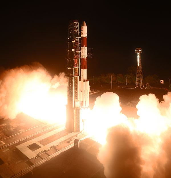
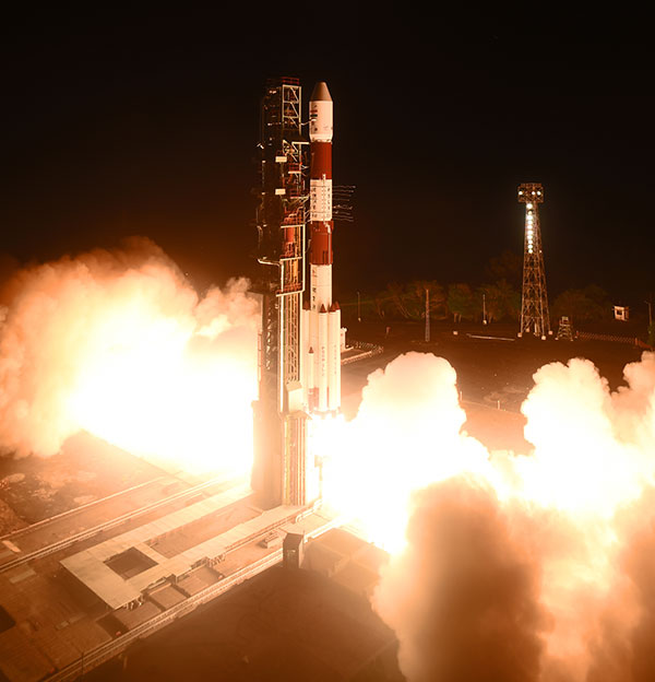
    In its 43rd flight, the India Space Research Organization’s (ISRO’s) Polar Satellite Launch Vehicle PSLV-C41 propelled the 1,425-kilogram IRNSS-1I Navigation Satellite into orbit.

    All three rubidium atomic clocks on IRNSS-1A have failed. A replacement satellite, IRNSS-1H, was launched on Aug. 31, 2017, but was not successfully deployed. This satellite, IRNSS-1I, is also a replacement satellite for IRNSS-1A.

    PSLV-C41 lifted off at 0404 hrs (4:04 a.m.) IST, as planned, from the spaceport’s First Launch Pad. After a flight lasting about 19 minutes, the vehicle achieved a sub-geosynchronous transfer orbit with a perigee (nearest point to Earth) of 281.5 km and an apogee of 20,730 km inclined at an angle of 19.2 degrees to the equator, following which IRNSS-1I separated from PSLV.

    After separation, the solar panels of IRNSS-1I were deployed automatically. ISRO’s Master Control Facility (MCF) at Hassan, Karnataka, took over the control of the satellite. In the coming days, orbit maneuvers will be performed from MCF to position the satellite at 55 degrees East longitude in the planned geosynchronous orbit with an inclination of 29 degrees to the equator.

    IRNSS-1I is the latest member of the Navigation with Indian Constellation (NavIC) system. NavIC, also known as Indian Regional Navigation Satellite System (IRNSS), is an independent regional navigation satellite system designed to provide position information in the Indian region and 1500 kilometers around the Indian mainland.

    A number of ground facilities responsible for IRNSS satellite ranging and monitoring, generation and transmission of navigation parameters, satellite control and network timing have been established in many locations across the country as part of NavIC.

  • India preps for navigation satellite launch

    India preps for navigation satellite launch

    Another navigation satellite is scheduled to join India’s NavIC constellation this week. IRNSS-1I is on the launchpad, with launch set for Thursday, April 12, at 04:04 (IST), according to the India Space Research Organization (ISRO).

    The 32-hour countdown activity began at 20:04 IST on Tuesday. Follow the launch here.

    All three rubidium atomic clocks on IRNSS-1A have failed. A replacement satellite, IRNSS-1H, was launched on Aug. 31, 2017, but was not successfully deployed. This satellite, IRNSS-1I, is also a replacement satellite for IRNSS-1A.

    Satellite IRNSS-1I will be the eighth satellite to join the NavIC constellation (formerly IRNSS). The satellite will be launched from First Launch Pad (FLP) of SDSC SHAR, Sriharikota, using India’s Polar Satellite Launch Vehicle (PSLV), in its 43rd flight (PSLV-C41) in XL configuration. The XL configuration is being used for the 20th time.

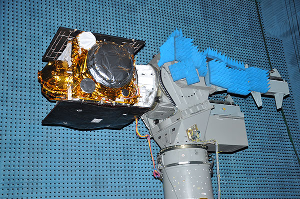
    IRNSS-1I undergoes testing at the Compact Antenna Test Facility. (Photo: ISRO)

    IRNSS-1I’s predecessors — IRNSS-1A, 1B, 1C, 1D, 1E, 1F and 1G — were launched by PSLV-C22, PSLV-C24, PSLV-C26, PSLV-C27, PSLV-C31, PSLV-C32 and PSLV-C33 in July 2013, April 2014, October 2014, March 2015, January 2016, March 2016 and April 2016 respectively. See the GPS World Almanac for details on the constellation.

    Like all other IRNSS satellites, IRNSS-1I also has a lift-off mass of 1425 kilograms. The configuration of IRNSS-1I is similar to IRNSS-1A, 1B, 1C, 1D, 1E, 1F and 1G.

    Like its IRNSS predecessors, IRNSS-1I also carries two types of payloads — navigation and ranging. The navigation payload of IRNSS-1I transmits signals for the determination of position, velocity and time. This payload is operating in L5-band and S-band. Rubidium atomic clocks are part of the navigation payload of the satellite.

    The ranging payload of IRNSS-1I consists of a C-band transponder, which facilitates accurate determination of the range of the satellite. It also carries Corner Cube Retro Reflectors for LASER Ranging.

  • System of Systems: M-code contract awarded

    System of Systems: M-code contract awarded

    Air Force awards M-code early use contract

    The Military Code (M-Code) Early Use (MCEU) contract will accelerate deployment of command and control of M-code capability to GPS IIR-M and GPS IIF satellites currently on orbit, as well as future GPS III satellites (like GPS III SV02 above). (Photo: Lockheed Martin)

    The U.S. Air Force has awarded Lockheed Martin a $45.5 million contract to provide military code (M-code) early use (MCEU) capability to GPS.

    MCEU will provide command and control of M-code capability to eight GPS IIR-M and 12 GPS IIF satellites on orbit, as well as future GPS III satellites, which the Air Force expects will begin launching in 2018.

    MCEU is envisioned as a way to accelerate M-code’s deployment to support testing and fielding of modernized user equipment in support of the warfighter.

    The U.S. Air Force’s MCEU contract directs Lockheed Martin to upgrade the existing Architecture Evolution Plan (AEP) Operational Control System (OCS), allowing it to task, upload and monitor M-code within the GPS constellation. The contract includes new software and hardware development that will be deployed in 2019 to worldwide ground facilities that support the Air Force’s GPS.

    The AEP OCS — maintained by Lockheed Martin under the GPS Control Segment (GCS) Sustainment Contract — controls the 12 GPS IIR, 8 IIR-M and 12 IIF satellites in orbit today. The company has successfully implemented several recent projects to modernize and sustain the system for the Air Force.

    Read more here.


    Performance under GPS Denial at NAVFEST

    By Christopher Ball

    U.S. Department of Defense units and university researchers gathered at Edwards Air Force Base, in California, to evaluate various aerial platforms in a degraded GPS environment. The week-long test event called Developmental Test Navigation Festival (DT NAVFEST) was the first large-scale program of its kind, according to James Cook, KC-46A project manager with the 418th Flight Test Squadron.

    “DT NAVFEST was established to provide a locally more realistic GPS jamming environment in which aircraft platforms and unmanned aerial vehicles could evaluate their performance under a degraded GPS signal,” Cook said. “Other locations around the U.S. provide such environments, but having it locally allowed for direct program input and cost savings to customers by not having to deal with the logistics costs of deploying to those locations.”

    Units that tested assets at Edwards included the Emerging Technologies Combined Test Force, the 411th, 416th, 419th and 461st Flight Test Squadrons, Stanford University, the University of Illinois, and the U.S. Army’s Special Operations Command. The GPS jammers and support came from the 746th Test Squadron at Holloman Air Force Base, New Mexico.

    “Live GPS jamming data is extremely difficult for academic labs to obtain due to the complexity of working with the Federal Aviation Administration and regional first responders,” said Wei Lee, test safety engineer with the 412th Test Wing. “It is crucial that the Department of Defense support basic research and development that is ongoing in our nation’s top academic institutions. Many of the low-technology readiness-level projects will eventually migrate from academic labs to defense industry and military applications. Allowing the labs to participate on a non-interference basis is a win-win situation.”

    The GPS jammers employed had a vertical reach of upwards of 30,000 feet.

    The 746th Test Squadron from Holloman Air Force Base, New Mexico, provided an array of GPS jamming equipment and support for DT NAVFEST at Edwards Air Force Base. The jammers provided a degraded GPS environment for testing multiple aerial platforms throughout the week. Testing was done from 1 to 6 a.m. each day to minimize impact on the community and civilian air traffic. (Photo: U.S. Air Force/Cole Johnson)

    IRNSS launch unsuccessful

    A launch of a new Indian Regional Navigation Satellite System (IRNSS) satellite failed when the protective fairing did not separate. The 1425-kg satellite was expected to expand the existing seven satellites of the NavIC constellation. The launch vehicle PSLV-C39 lifted the satellite on Aug. 31.

    The three phases of the launch went smoothly, but the heat shield that was supposed to be separated in the fourth stage could not be detached. IRNSS-1H was planned as a replacement satellite for IRNSS-1A.