Electronic warfare in the Middle East and Ukraine is affecting air travel far beyond the battlefields, unnerving pilots and revealing unintended consequences of a tactic that experts believe will become more widespread, reportedThe New York Times.
Planes are losing satellite signals, flights have been diverted and pilots have received false location reports or inaccurate warnings that they were flying close to terrain, according to European Union safety regulators and an internal airline memo viewed by The New York Times. The Federal Aviation Administration (FAA) has also warned pilots about GPS jamming in the Middle East.
Following Russia’s invasion of Ukraine in early 2022, radio frequency interference only continues to increase across the Middle East as of autumn 2023. These interferences can involve jamming GNSS signals to obstruct or block them using noise, or mimicking signals to trick GNSS receivers into picking up counterfeit satellite signals, known as spoofing.
Aircraft systems have been unable to detect GPS spoofing and ultimately correct for it. According to Opsgroup, an organization that monitors changes and risks in the aviation industry, one Embraer jet bound for Dubai nearly veered into Iranian airspace in September before the pilots figured out the plane was chasing a false signal.
“We only realized there was an issue because the autopilot started turning to the left and right, so it was obvious that something was wrong,” crew members reported to Opsgroup.
Issues arise
With the rise of electronic warfare, the strain on aviation could be a sign of more serious economic and security issues.
The U.S. government calls GNSS signals “an invisible utility.” Smartphones, cars, stock exchanges, data centers and countless industries rely on them for time, navigation or both. Similar systems exist around the world, such as Galileo in Europe, Glonass in Russia, QZSS in Japan, NavIC in India and BeiDou in China. One study from Britain said a five-day disruption of satellite signals could cost the country $6.3 billion.
Minor interference with GPS signals is fairly common. GPS jamming devices, while illegal to use, are inexpensive and easy to obtain from vendors on the internet. Governments, too, have been more willing to overtly interfere with signals as a tactic in electronic warfare.
It is not always possible to distinguish jamming from spoofing, or to determine who is behind the interference. Israel said in mid-October it had restricted GPS in the region and had warned pilots not to rely on satellite navigation systems for landing.
Russian interference is well-documented. A 2019 report by the Washington-based analytical nonprofit group C4ADS showed extensive spoofing from a Russian-controlled air base in Syria. Reports also indicated that, when Russian President, Vladimir Putin, traveled to remote locations or Russian-occupied Crimea, he was flanked by mobile GPS-spoofing technology.
Jamming is common in conflict zones. Spoofing, until recently, was considered rare.
The interference has been felt up to 190 miles away from battlefields and “appears to go well beyond simple military mission effectiveness,” according to Eurocontrol, Europe’s primary air-traffic-control manager. The worst-affected regions include the aerial space above the Black Sea area from Turkey to Azerbaijan; the Mediterranean Sea extending from Cyprus to Libya; the Baltic Sea near Poland and Latvia; and the Arctic near Finland and Norway.
Airbus said it recorded nearly 50,000 interference events on its aircraft last year, more than four times as many as the year before. This came on top of an over twentyfold jump in radio-interference events from 2017 to 2018, as recorded by a voluntary incident reporting system run by Eurocontrol. Eurocontrol said the increased jamming since 2018 was most likely meant to interfere with battlefield UAVs.
In the Middle East, there have been reports of false signals telling pilots their aircraft were directly above the airport in Tel Aviv despite being far away. Opsgroup said it had received around 50 similar reports. In some cases, onboard equipment showed that planes were approaching airports in Baghdad, Cairo or Beirut, Lebanon, when they were not.
Looking ahead
Spoofing is hard to distinguish because the signal appears legitimate. Only Europe’s Galileo incorporates an authentication system that can verify when a signal is from its satellites. Galileo, which currently is the most accurate and precise navigation satellite system, plans to introduce an even stronger level of authentication, according to the European Commission.
But even Galileo’s authentication cannot protect against one of the most dreaded types of spoofing, known as “meaconing.” In a meaconing attack, a spoofer would record satellite signals, and then rebroadcast them with an amplification or a delay. Experts have not publicly confirmed any meaconing attacks in the Middle East.
Opsgroup said the latest events should prompt manufacturers to re-examine the integration of satellite signals in aircraft electronics, known as avionics, without a safeguard that can identify false signals.
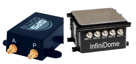
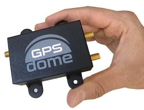
In this environment of intentional GPS jamming and spoofing, Israel has produced a leading anti-jam technology company, InfiniDome, located in Caesarea. According to co-founder Omer Sharar, the company has been working to defend GPS signals for more than seven years and has also seen the rise of devices to jam the GPS L1 frequency that anyone can buy online for $100.
Most readily available jammer electronics only output interference disrupting GPS L1, which is commonly installed for vehicle tracking and UAV guidance. InfiniDome says it has successfully protected trucking, UAV operations and others in Israel and around the world with its Infinidome GPSdome-1 and GPSdome-2 anti-jam products.
It is clear the conflict’s repercussions extend well beyond the battlefield, highlighting the critical need for security assessments or alternative PNT systems to protect civilians. While there is going to be a significant impact on commercial airline travel to and from Israel while hostilities continue, there is hope for a possible long-term solution for the intense jamming that has plagued the region for years.
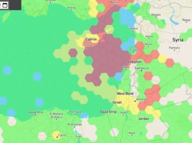
Just as I was beginning to write this article, war broke out between Israel and terrorist forces in Gaza. It would seem that the rockets used by Gaza were aimed rather than carrying on-board guidance, while Israeli airforce bomb/rocket attacks have been carried out with some degree of precision. Nevertheless, jamming in Israel may still be relevant to the ongoing conflict and any on-going commercial aircraft activity. However, it seems from the diagram of jamming below, that the Gaza strip is virtually interference free.
One of the things you can be sure of in the Ukraine-Russia war is that one side or the other is jamming the other’s communications and sat-nav guidance systems. An apparent consequence is that there is likely some “spill-over” to adjacent areas. For Israel, however, it looks like it’s more directed jamming rather than incidental.
Israel GPS jamming. (Image: GPS Jam.org)
In this environment of intentional GPS jamming, it’s not surprising that Israel has produced a leading anti-jam technology company, called InfiniDome, in Caesarea (between Haifa and Tel-Aviv). According to co-founder Omer Sharar, the company has been working to defend GPS signals for more than seven years and has also seen the rise of devices to jam the GPS L1 frequency that anyone can buy online for $100.
Just as Ukraine is throwing explosive cardboard UAVs with little cost at Russian occupying forces, a few carefully placed low-cost jammers could inflict serious damage on a country’s navigation capabilities.
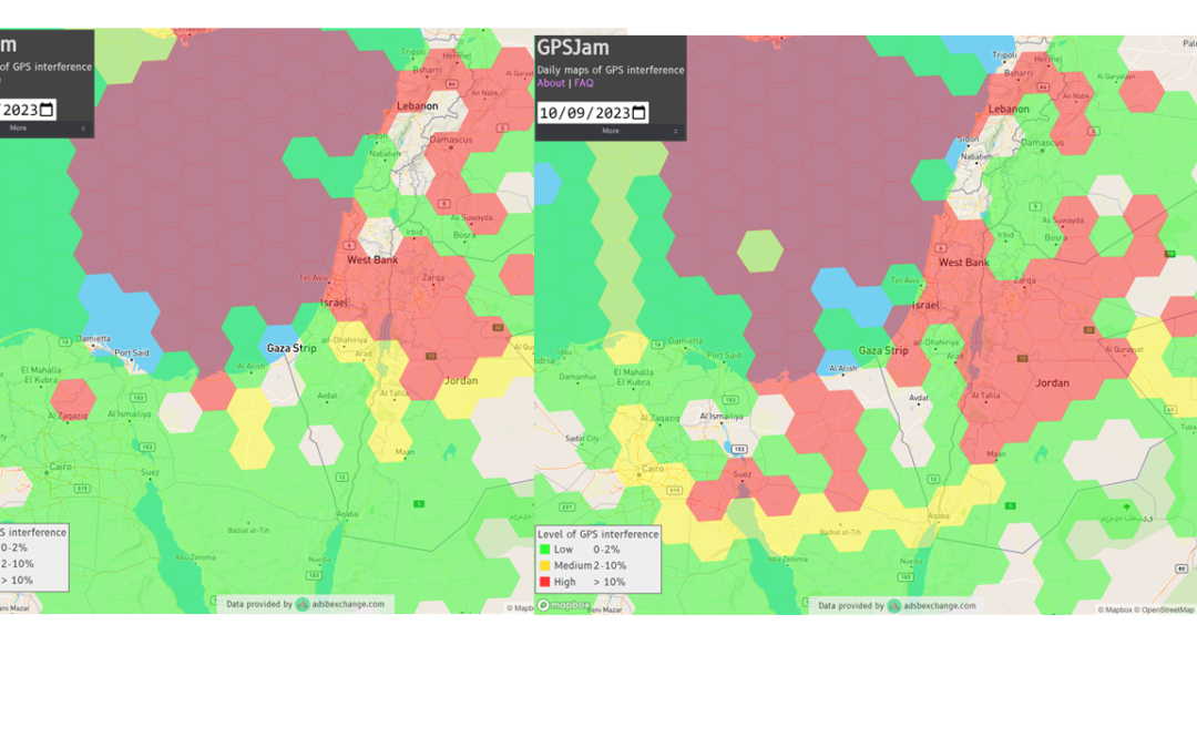
However, a 2019 presentation by Todd Humphreys identified the source of interference and spoofing at that time, a Russian high-power jammer located at a Russian base in Syria.
Humphreys used instrumentation on the International Space Station (ISS) to gather data on the directed interference but concluded that the jamming in Israel could be a consequence of Russia’s efforts to protect its troops in Syria from UAV attacks. The Russian Khmeimim Air Base is on the Mediterranean coast and attacks are thought to come from rebels within Syria.
With the current GPS jamming out of Syria, most commercial aircraft traffic flying into Ben Gurion International Airport is significantly affected as flights cross from over the coast from the Mediterranean. Longer flight tracks deeper southeast into Israel are necessary, probably relying on VOR and DME ground station waypoints before turning back northwest to capture the instrument landing system (ILS) into the airport. This costs time and fuel and causes aircraft to overfly settlements where noise can be a real problem.
Most readily available jammer electronics only output interference disrupting GPS L1, which is most commonly installed for vehicle tracking and UAV guidance. InfiniDome has successfully protected trucking, UAV operations and others in Israel and around the world with its Infinidome GPSdome-1 and GPSdome-2 anti-jam products.
Two antennas 10 cm to 25 cm apart enable GPSDome-1 algorithms to detect and null out a GPS L1 jammer. GPSDome-2 accommodates up to four antennas and can null up to three directional signals on both GPS L1 and L2 or GPS L1 and GLONASS L1.
InfiniDome is currently working with an aerospace company to integrate its anti-jam technology with airborne inertial/GPS and qualify the integrated system for use in civil aviation, with the objective of maintaining max 3% drift when fully jammed. This will introduce certified anti-jam technology into civil aviation use — something that will provide some jamming protection, which airlines desperately need going forward. In addition, other high-end UAV manufacturers are potential customers for this new system.
While the ongoing conflict and the devastating loss of life is forefront as each day of the war passes, these anti-jam solutions may ultimately help solve signal degradation problems. While there is going to be a significant impact on commercial airline travel to and from Israel while hostilities continue, we can maybe see the way to a possible long-term solution for the intense jamming from which the region has suffered for many years.
Israel has declared war on the Palestinian militant group Hamas after it carried out an unprecedented attack by air, sea and land on October 7, 2023.
The large-scale surprise attack has left more than 1,200 dead in Israel, said Israel Defense Forces spokesperson Lt. Col. Jonathan Conricus in an update on October 11. It has since prompted retaliatory Israeli airstrikes on Gaza that have killed more than 1,055 people.
During the ongoing conflict between Israel and Hamas, the Middle East is witnessing a significant shift in the patterns of GPS interference, with data showing an increase in disruptions compared to just a week prior, according to Defence and Security Middle East.
Reports have surfaced indicating Hamas has actively jammed Israeli communication systems during the initial stages of the conflict. This strategic move highlights the increase of jamming GPS and communication networks in modern warfare scenarios, where precision and coordination are imperative.
Positioning, navigation and timing (PNT) services play a role in a variety of military systems and civil technologies. These services not only guide precision warfare, but also facilitate efficient transportation, communication and various civilian applications.
The Middle East has a history of being a focal point for jamming and spoofing activities, impacting not only security but also regional stability and even commercial flights.
For example, there have been recent reports of recurring interference allegedly caused by Russian systems in Syria, which frequently disrupts air traffic at Tel Aviv’s Ben Gurion airport. Regulatory bodies, such as the Federal Aviation Administration, the European Union Aviation Safety Agency, and Israel’s aviation authority, advised airlines to exercise caution when operating in the airspace of the region. Multiple airlines have now canceled or suspended flights.
With airlines reducing services and regulatory bodies advising caution, the conflict’s repercussions extend well beyond the battlefield, highlighting the critical need for security assessments or alternative PNT systems to protect civilians.
An approach for ground vehicles using carrier-phase and inertial measurement data
The combination of easily accessible low-cost GNSS spoofers and the emergence of increasingly automated GNSS-reliant ground vehicles prompts a need for fast and reliable GNSS spoofing detection. To underscore this point, Regulus Cyber, an Israeli cybersecurity company, recently spoofed a Tesla Model 3 on autopilot mode, causing the vehicle to suddenly slow and unexpectedly veer off the main road.
Among GNSS signal authentication techniques, signal-quality monitoring (SQM) and multi-antenna could be considered for implementation on ground vehicles. However, SQM tends to perform poorly on dynamic platforms in urban areas where strong multipath and in-band noise are common, and multi-antenna spoofing detection techniques, while effective, are disfavored by automotive manufacturers seeking to reduce vehicle cost and aerodynamic drag. Thus, there is a need for a single-antenna GNSS spoofing detection technique that performs well on ground vehicles, despite the adverse signal-propagation conditions in an urban environment.
In a concurrent trend, increasingly automated ground vehicles demand ever-stricter lateral positioning to ensure safety of operation. An influential study calls for lateral positioning better than 20 centimeters on freeways and better than 10 centimeters on local streets (both at a 95% probability level). Such stringent requirements can be met by referencing lidar and camera measurements to a local high-definition map, but poor weather (heavy rain, dense fog or snowy whiteout) can render this technique unavailable.
On the other hand, progress in precise (decimeter-level) GNSS-based ground vehicle positioning, which is impervious to poor weather, has demonstrated surprisingly high (above 97%) solution availability in urban areas. This technique is based on carrier-phase differential GNSS (CDGNSS) positioning, which exploits GNSS carrier-phase measurements having millimeter-level precision but integer-wavelength ambiguities.
Key to our promising results is the tight coupling of CDGNSS and inertial measurement unit (IMU) data, without which high-accuracy CDGNSS solution availability is significantly reduced due to pervasive signal blockage and multipath in urban areas. Tight coupling brings millimeter-precise GNSS carrier-phase measurements into correspondence with high-sensitivity and high-frequency inertial sensing. Our particular estimation architecture incorporates inertial sensing via model replacement, in which the estimator’s propagation step relies on bias-compensated acceleration and angular rate measurements from the IMU instead of a vehicle dynamics model.
As a consequence, at each measurement update, an a priori antenna position is available whose delta from the previous measurement update accounts for all vehicle motion sensed by the IMU, including small-amplitude high-frequency motion caused by road irregularities. Remarkably, when tracking authentic GNSS signals in a clean (open-sky) environment, the GNSS carrier-phase predicted by the a priori antenna position and the actual measured carrier phase agree to within millimeters.
The research described in this article pursues a novel GNSS spoofing-detection technique based on a simple but consequential observation: it is practically impossible for a spoofer to create a false ensemble of GNSS signals whose carrier-phase variations, when received through the antenna of a target ground vehicle, track the phase values predicted by inertial sensing. In other words, antenna motion caused by factors such as road irregularities or rapid braking or steering is sensed with high fidelity by an onboard IMU but is unpredictable at the sub-centimeter-level by a would-be spoofer.
Therefore, the differences between IMU-predicted and measured carrier-phase values offer the basis for an exquisitely sensitive GNSS spoofing-detection statistic. What is more, such carrier-phase fixed-ambiguity residual cost is generated as a byproduct of tightly coupled inertial-CDGNSS vehicle position estimation.
Two difficulties complicate the use of fixed-ambiguity residual cost for spoofing detection. First is the integer-ambiguous nature of the carrier-phase measurement, which causes the post-integer-fix residual cost to equal not the difference between the measured and predicted carrier phases (as would be the case for a typical residual), but rather modulo an integer number of carrier wavelengths. Such integer folding complicates development of a probability distribution for a detection test statistic based on carrier-phase fixed-ambiguity residual cost.
Second, the severe signal multipath conditions in urban areas create thick tails in any detection statistic based on carrier-phase measurements. Setting a detection threshold high enough to avoid false spoofing alarms caused by mere multipath could render the detection test insensitive to dangerous forms of spoofing. Reducing false alarms by accurately modeling the effect of a particular urban multipath environment on the detection statistic would be a Sisyphean undertaking, requiring exceptionally accurate up-to-date 3D models of the urban landscape, including materials properties.
Our work takes an empirical approach to these difficulties. It does not attempt to develop a theoretical model to delineate the effects of integer folding or multipath on its proposed carrier-phase fixed-ambiguity residual cost-based detection statistic. Rather, it develops null-hypothesis empirical distributions for the statistic in both shallow and deep urban areas, and uses these distributions to demonstrate that high-sensitivity spoofing detection is possible despite integer folding and urban multipath.
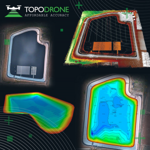
On Jan. 12, TOPODRONE used its synchronized lidar, airborne photogrammetry and bathymetric surveying methods to study a floating solar farm in Israel. This was completed upon request from the UAV service provider ERELIS, to help conduct a pilot project of reservoir surveying with a UAV for ETZ HADEKEL in northern Israel.
As the surface of the reservoir in Northern Israel is covered by solar panels, it is difficult to use standard methods of surveying from a boat. The goal of this study was to create 3D models, which can be used for high-precision assessments of sediment volumes, general monitoring of reservoir banks and visual monitoring.
Image: TOPODRONE
During this project, ERELIS performed two-stage UAV surveying to create the 3D model of the reservoir. In the first stage, aerial photogrammetry and lidar surveys were performed using a DJI M300 UAV. The UAV was equipped with the P61 TOPODRONE camera and a lidar high-resolution system to determine the location of obstacles. The lidar scanning provided accurate detection of cables in the water.
The second stage included an underwater bathymetric survey using the TOPODRONE AQUAMAPPER mounted to the DJI M300 UAV. The flight mission was planned and executed with the UgCS software by SPH Engineering.
All data collected from the study was processed by TOPODRONE Post Processing software. This generated a georeferenced orthophoto map, a 3D model of the relief and objects, a 3D model of the bottom of the reservoir and a model of contour lines and isobaths.
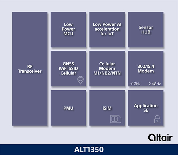
Innovative chip offers multiple ultra-low power connectivity options and low-power processing for internet of things (IoT) market
Sony Semiconductor Israel has launched the ALT1350 for the global market. The ALT1350 is a cellular LTE-M/NB-IoT chipset designed to enable additional low-power wide-area (LPWA) communication protocols, as well as GNSS, in a single chipset.
The ALT1350 incorporates a sensor hub to collect data from the sensors while maintaining ultra-low power consumption. It also provides cellular and Wi-Fi-based positioning and is tightly integrated to provide power-optimized concurrent LTE and GNSS to accommodate various tracking applications, which can be demanding with a single chip.
“The market demand for this multiprotocol, ultra-low power IoT chipset is intensifying, and Sony’s ALT1350 chipset meets that demand,” said Nohik Semel, CEO at Sony Semiconductor Israel. “This is the game changer we’ve been waiting for, which will enable IoT deployments, utilizing universal connectivity on edge processing and multiple location technologies.”
Diagram: Sony
The ALT1350 is an advanced cellular IoT solution, with architecture that resolves IoT service provider’s power-consumption concerns. Its optimized standby mode (eDRX) reduces power consumption by 80% when compared to the current generation and by 85% when using it to send short messages.
Overall improvements in the system’s power consumption will enable four times longer battery life for a typical device, enabling additional functionalities and use cases with smaller batteries.
The ALT1350’s sub-GHz and 2.4 GHz integrated transceiver enables hybrid connectivity for smart meters, smart cities, trackers and other devices. This enhances coverage, reduces costs and further decreases power consumption using IEEE 802.15.4-based protocols such as Wi-Sun, U-Bus Air and wM-Bus, in additional point-to-point and mesh technologies.
The chipset is designed to support the wide-ranging market needs of utilities, vehicle, tracking devices, smart cities, connected health and other verticals. Device manufacturers across all verticals can take advantage of its low power consumption, long-lasting battery life, mature Release 15 LTE-M/NB-IoT software stack, and future compatibility with 3GPP release 17.
All these guarantee longevity and ensure the ALT1350 will operate with 5G networks. It contains an additional LPWA radio transceiver with targeting operation in <1 GHz and 2.4 ISM bands for universal connectivity options.
The chipset provides advanced on-the-edge low power processing capabilities, ranging from data collection, low power AI/ML processing of the data, and MCU to enable IOT applications on the chip.
The device is now sampling to lead customers and will become commercially available in 2023. The ALT1350 also includes a secure element for application usage and integrated SIM designed for PP-0117 to meet GSMA requirements.
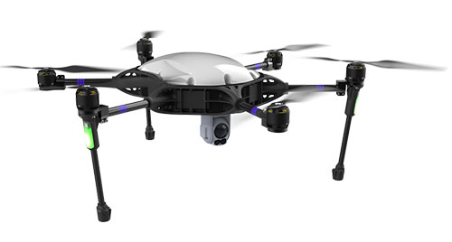
InfiniDome, Honeywell and Easy Aerial have successfully demonstrated their new Robust Navigation System for UAVs. The system integrates GPS anti-jamming technology, a radar velocity system and an inertial navigation system into a resilient system that enables UAVs to safely operate in GNSS-challenged or denied environments.
UAV developers or end users currently try to solve the problem of GNSS jamming either by creating “safe landing protocols” in GNSS-challenged environments or by adding various types of sensors such as lidar or optical. These sensors may not work in certain scenarios, such as when flying too high, too low or too fast; in fog or darkness; or above the ocean.
The Robust Navigation System, jointly developed by Honeywell and infiniDome, tightly pairs the GNSS-based UAV-tailored Honeywell Compact Inertial Navigation System (HCINS) with infiniDome’s GNSS anti-jamming technology (GPSdome), integrated with Honeywell’s Radar-based Velocity System (HRVS). It can be installed on almost any UAV, providing continuous, accurate navigation data in GNSS-challenged or fully GNSS-denied environments.
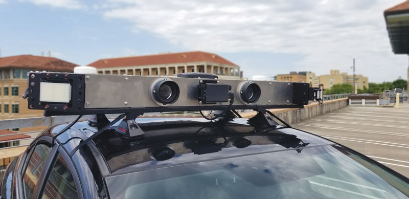
The companies demonstrated the new navigation system for Israeli defense prime contractors and drone companies and government end-users at a testing range in the center of Israel. The system was tested against two military-grade directional jammers of different types and bandwidths on customized Osprey Hexa-copter with a PixHawk 2.1 Cube Black flight controller. The GPS 1 input was a Here2 standard GNSS receiver and antenna module; the GPS 2 input was the Robust Navigation System (GPSdome 1.03 + HCINS + HRVS).
A customized Osprey Hexa-copter demonstrated the Robust Navigation System. (Photo: InfiniDome)
The goal of the demo was to show that a UAV in a GNSS-challenged environment (single direction of jamming) and fully denied environment (multiple directions of powerful jamming) can perform autonomous tasks accurately and safely without the pilot needing to assume manual control. This included beyond-visual-line-of-sight flights.
Each test was designed to be more difficult than the preceding one and would be executed only if the latter was successful. The intention was to find the barrier at which the system fails.
The first test was maintaining the UAV height (AltHold), position (PosHold) and Loiter autonomously under jamming conditions, followed by a simple point-to-point autonomous task under the same jamming conditions.
The UAV then performed a fully autonomous task including executing a 10-point polygon and returning to the same position accurately under the same jamming conditions. Finally, the UAV was tested for lift-off performance, executing the full polygon and landing under the jamming conditions.
Protected by the Robust Navigation System, the UAV passed all planned tests.
The inauguration of the Navigation Technologies Center took place in March. (Photo: IAI)
The new center will focus on developing and producing navigation systems for the battlefield, and plans to implement a co-developed, non-GPS accurate navigation technology
A Navigation Technology Center dedicated to developing and producing non-GPS navigation systems has been launched by Israel’s Ministry of Defense (IMOD) and Israel Aerospace Industries (IAI).
In the new center, IAI will develop and manufacture highly accurate inertial sensors for production of next-generation navigation systems, and will significantly increase their performance and capabilities. The sensors will be implemented in operational systems within Israel’s defense systems, enabling Israel to continue to address challenges of the modern battlefield.
The technology to be developed at the center is based on years of research and collaboration between the Directorate of Defense Research & Development (DDR&D) and IAI.
The center was established at the Tamam Division of IAI’s Systems Missiles and Space Group, which specializes in electro-optics and navigation. IAI has served as the inertial navigation system (INS) house of the State of Israel since 1964. Tamman is based in Yahud, a suburb of Tel Aviv.
“In launching the new compound, DDR&D demonstrates our position at the forefront of technology and its contribution to Israel’s technological independence,” said Brig. Gen. Yaniv Rotem, chief of research and development at DDR&D. “The extensive know-how and experience accumulated at DDR&D and Tamam, our partners, allowed us to challenge ourselves with this new endeavor and accomplish something impressive. The follow-up program is just as challenging, and we plan to work diligently until we prove the new capability in the various applications and in collaboration with IDF units.”
“Our partnership with IMOD DDR&D dates back many years,” said Avi Elisha, Tamam general manager. “We work together to achieve the ongoing enhancement of the innovative navigation systems for Israel. The new center we launched will allow highly accurate navigation capabilities with IAI’s unique technologies. Only a handful of countries have this technology, which is a game-changer in the field of inertial navigation.”
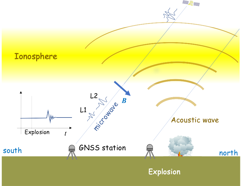
A 2020 explosion in Lebanon’s port city of Beirut led to a southward-bound, high-velocity atmospheric wave that rivaled ones generated by volcanic eruptions.
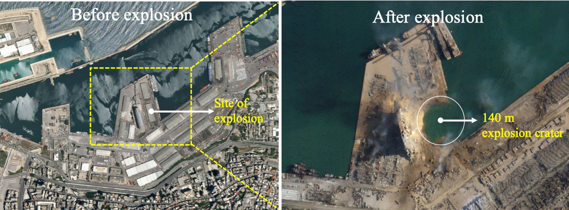
The epicenter in Beirut, before and after the explosion.(Image: Bhaskar Kundu, et al. Scientific Reports. Feb. 2, 2021).
Just after 6 p.m. local time (15:00 UTC) on Aug. 4, 2020, more than 2,750 tons worth of unsafely stored ammonium nitrate exploded in Lebanon’s port city of Beirut, killing around 200 people, making more than 300,000 temporarily homeless, and leaving a 140-meter-diameter crater in its wake. The blast is considered one of the most powerful non-nuclear, man-made explosions in human history.
Now, calculations by Hokkaido University scientists in Japan have found that the atmospheric wave from the blast led to electron disturbances high in Earth’s upper atmosphere. They published their findings in the journal Scientific Reports.
The team of scientists, which included colleagues from the National Institute of Technology Rourkela in India, calculated changes in total electron content in Earth’s ionosphere: the part of the atmosphere from around 50 to 965 kilometres in altitude. Natural events like extreme ultraviolet radiation and geomagnetic storms, and man-made activities like nuclear tests, can cause disturbances to the ionosphere’s electron content.
“We found that the blast generated a wave that travelled in the ionosphere in a southwards direction at a velocity of around 0.8 kilometres per second,” says Hokkaido University Earth and Planetary scientist Kosuke Heki. This is similar to the speed of sound waves travelling through the ionosphere.
The team calculated changes in ionospheric electron content by looking at differences in delays experienced by microwave signals transmitted by GPS satellites to their ground stations. Changes in electron content affect these signals as they pass through the ionosphere and must be regularly taken into consideration to accurately measure GPS positions.
The ionospheric disturbance caused by an explosion can be detected by differential ionospheric delays of microwave signals of two carrier frequencies from global navigation satellite system (GNSS) satellites. (Image: Bhaskar Kundu, et al. Scientific Reports. Feb. 2, 2021).
The scientists also compared the magnitude of the ionospheric wave generated by the Beirut blast to similar waves following natural and anthropogenic events. They found that the wave generated by the Beirut blast was slightly larger than a wave generated by the 2004 eruption of Asama Volcano in central Japan, and comparable to ones that followed other recent eruptions on Japanese islands.
The energy of the ionospheric wave generated by the Beirut blast was significantly larger than a more energetic explosion in a Wyoming coal mine in the USA in 1996. The Beirut blast was equivalent to an explosion of 1.1 kilotons of TNT, while the Wyoming explosion was equivalent to 1.5 kilotons of TNT. The total electron content disturbance of the Wyoming explosion was only 1/10 of that caused by the Beirut blast. The scientists believe this was partially due to the Wyoming mine being located in a somewhat protected pit.
A train arrives at Tel Aviv University Station on the Israeli Railway in Tel Aviv. (Photo: svarshik/iStock Editorial/Getty Images Plus/Getty Images)
InfiniDome Ltd., a GPS security company, is joining with with Israeli partner Focus Telecom, in a new country-wide project with Israel Railways. The project involves deployment by Focus Telecom of GPS repeaters at more than 30 railway stations across Israel, providing accurate, location-based service indoors at all locations for a new Israel Railways ticketing app.
A critical component of the project is a monitoring service that detects and provides alerts of any GPS disruption or interference in real time, as they are identified. This is facilitated by infiniDome’s IoT GPSensors and its cloud-based GPS monitoring service, infiniCloud.
“Incorporating infiniDome’s proven resilient PNT capability to monitor and protect such a critical GPS service is a necessary enhancement for government designated critical infrastructures,” said Ehud Sharar, Focus Telecom CEO.
Photo: Focus Telecom
InfiniDome’s monitoring technology for critical assets detects and alerts operators of threats and disruptions of the essential GPS signals. These threats can originate from both malicious or natural causes.
“GPSensor IoT technology combined with our infiniCloud GPS security cloud assures real-time alerts about jamming attacks. All GPS signal data and its assured integrity are available as real time data so Israel Railways can react immediately and reduce downtime of the network,” said Omer Sharar, infiniDome CEO.
Israel Railways is the cornerstone of Israeli critical infrastructure. In 2018, Israel National Railway carried 68 million passengers. This same infiniDome GPS monitoring and protection technology is now available to defend critical infrastructure assets worldwide.
GPS technology is doing far more than helping us navigate or receive accurate time. It is now being used to fight the spread of the global COVID-19 pandemic.
Global navigation satellite systems are being used to collect big data on travel and contact, but they are also being used in more unconventional ways: for example, quarantine enforcement and sanitation technology.
Read on to learn about a few recent developments in the world of GNSS/GPS that are bolstering the battle against the novel coronavirus.
Electronic monitoring enforces quarantine
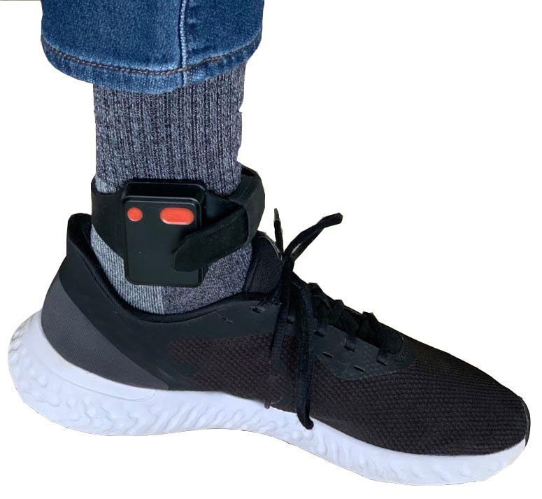
There is a surge of applying ankle monitors to track sick individuals and deter them from spreading the virus further. According to BloombergBusinessweek, one business is thriving because of it: providers of electronic ankle monitors.
Kentucky courts are requiring GPS ankle monitors for people who test positive for COVID-19 and refuse to self-quarantine. Kentucky couple Elizabeth and Isaiah Linscott were two of a growing number of people placed under house arrest after Elizabeth tested positive for COVID-19 and denied signing the Self-isolation and Controlled Movement Agreed Order, a health department document promising she would stay home.
Photo: Regulus Cyber
Elizabeth told Louisville television station WAVE 3 News that she did not sign because she disagreed with the wording of the document. She said that she was concerned about having to contact the health department before traveling, even in the case of an emergency.
“My part was if I have to go to the ER, if I have to go to the hospital, I’m not going to wait to get the approval to go,” she said.
A few days after Elizabeth refused to sign the paperwork, her husband opened their door to an entourage of law enforcement officers serving them with a Health Department order to wear ankle monitors.
“I open up the door, and there’s like eight different people, five different cars, and I’m like ‘what the heck’s going on?’ This guy’s in a suit with a mask. It’s the Health Department guy, and they have three papers for us. For me, her and my daughter,” Isaiah said.
The Linville family is now confined to a 200-foot radius. If they leave their designated quarantine area, their ankle monitors will alert law enforcement.
Alternative to prison
The number of people on house arrest in the United States and across the world has surged as corrections departments struggle to slow the spread of the coronavirus within prisons. An estimated 25 to 30 percent more people are wearing ankle monitors in comparison with a few months ago, according to Bloomberg Businessweek. The U.S. Federal Bureau of Prisons reported a 160 percent increase in home confinement from late March to July. European corrections departments have similarly put thousands of inmates on house arrest in the last few months.
“Demand has spiked everywhere,” BI Inc. monitoring equipment executive Robert Murnock said to Bloomberg. “We’re getting calls from different jurisdictions and other countries we’ve never worked with.”
Efforts to reduce crowding in prisons mean that the electronic monitoring industry is one of very few industries benefiting financially from the coronavirus pandemic.
“Coronavirus gives electronic monitoring companies an opportunity like they’ve never had before to expand,” parole reform expert James Kilgore said.
On Aug. 3, Singapore announced the rollout of electronic tracking devices to enforce quarantine. Travelers will be required to wear GPS and Bluetooth-powered tracking devices that notify authorities if quarantine is broken or the device is tampered with. The rule went into effect on Aug. 11 and applies to all incoming travelers — resident or nonresident — over the age of 12.
On Aug. 20, the premier of Western Australia, Mark McGowan , said his government could soon force people in hotel quarantine to wear electronic monitoring equipment if they are deemed a risk. “If we identify people who are potential flight risks or who might have a criminal history, we are looking at applying monitoring bracelets to them,” he said.
An estimated 25 percent to 30 percent more prisoners are wearing bracelets now compared to the pre-outbreak period. In the U.S., the Federal Bureau of Prisons has placed about 4,600 inmates in home confinement, a 160 percent increase since the end of March.
“Demand has spiked everywhere,” said Robert Murnock, vice president for partnership development at BI Inc., a provider of EM technology.
The emergency shift to electronic monitoring spurred by COVID-19 may foretell a long-term shift toward use as an alternative to prison time, reducing clutter and the risk of the virus spreading among inmates.
Photo: LeoPatrizi/E+/Getty Images
Contact tracing via mobile phones
Israel is using covert mobile phone data to track the spread of COVID-19. On July 1, the Knesset approved a bill temporarily reauthorizing mass surveillance of coronavirus-infected citizens by the Shin Bet, Israel’s internal security service. The original program lasted from mid-March to June 9.
The contact-tracing program works like this. When a patient is diagnosed with COVID-19, the Israeli Health Ministry provides their personal information — including their mobile number — to the Shin Bet. The Shin Bet then consults a classified database of every person who uses Israeli telecom services to determine who came into contact with the infected individual for more than 15 minutes at a time. After the Shin Bet sends information back to the Health Ministry, the Health Ministry notifies those people via text and tells them to self-quarantine.
The Shin Bet’s newfound role in public health enforcement is quite different from its usual focus. Former Shin Bet agents say the COVID-19 mobile phone tracking technology was originally developed as a counterterrorism measure, and the tracking system being used on Israeli civilians is almost identical to that used for suspected terrorists.
“It’s the same system, the same methods,” retired Shin Bet agent Arik Brabbing said to BBC. “We know that someone was here in the park. We can get from the [mobile phone] company all the details about the hour, the place, exactly the place… and we can understand who else was around.”
Supporters of the mass surveillance program, including Prime Minister Benjamin Netanyahu, argue that reduced privacy is necessary to curb the spread of the virus. However, the Israeli government has come under fire by opponents who claim that the program is intrusive and undemocratic.
Israel’s contact tracing procedures are more secretive than those of South Korea and Taiwan, other countries that mandate central mass surveillance. South Korea and Taiwan both enforce quarantines with mobile-phone tracking, and both have built publicly available COVID-19 data platforms.
The South Korean government has disseminated detailed — but anonymized — information about COVID-19 carriers, including their travel routes and treatment facilities. Citizens broadly support these measures — a testament to collectivism in Korean culture.
Civic engagement and enthusiasm for fighting the pandemic is also remarkable in Taiwan, where the public has been collaborating with the government on a town hall-style website called vTaiwan. Citizen-led initiatives, like a GPS-powered tool for tracking face mask supplies, have been applied nationwide.
Meanwhile in Europe, eight major telecom companies, including Vodafone and Orange, have been supplying anonymized metadata to the European Commission to model and predict the spread of the virus. In the United States, the Centers for Disease Control and Prevention is soliciting GPS data from mobile advertising companies rather than carriers themselves.
The two tech giants, Apple and Google, made it easier for health agencies to join its coronavirus exposure notification system, creating a new built-in app within iOS and Android. The app provides real-time notification to users when they are exposed to a sick person.
Virus-killing robots may roam the streets
GPS-based robots, drones and autonomous cars are being deployed to sanitize outdoor spaces, transport medical equipment, and announce safety information to the public.
Robots began rolling around the streets of Wuhan, the original epicenter of the coronavirus outbreak, as early as January. China was the first to deploy robots of this type, but India, Spain, France and other countries have followed in their footsteps. In addition to the chemical-spray approach, some companies are pioneering mobile disinfection robots armed with large ultraviolet-C germicidal lights.
Apollo, the autonomous vehicle company of multinational internet giant Baidu, has partnered with Chinese self-driving startup Neolix to transport food and supplies to Beijing Haidian Hospital. Every morning at 10:30 a.m, an unmanned car delivers meals to about 100 frontline workers. The process eliminates direct contact, protecting the safety of food service workers, hospital staff, and patients.
Zhangjiang Artificial Intelligence Island
A fleet of Apollo and Neolix’s unmanned cars is also responsible for disinfecting all roads on Zhangjiang Artificial Intelligence Island, an 100,000-square-meter industrial complex in Shanghai. The vehicles are loaded with up to 160 liters of spray disinfectant and can cover the island’s entire road system in about half an hour.
The vehicles at Zhangjiang AI double as nighttime surveillance bots. They patrol the island and make sure that guests are adhering to coronavirus protocols, alerting security personnel if they note suspicious activity.
In addition to using drones to spray disinfectant, South Korea’s government has leveraged the technology for public announcements. On July 4, 300 drones lit the sky above Seoul in a show of appreciation for frontline workers. The drones executed a 10-minute synchronized show that included images of face masks, hand washing, and social distancing.
Summary
As COVID-19 continues to ravage the globe, governments rely on GPS to track the virus, contain it, and fight against it. The battle against coronavirus is still being waged on a global scale, utilizing GPS as a weapon along with many other existing technologies.
The pandemic changed the world forever, and it also highlighted the power of tracking and monitoring location of people and machines. It is another testament to the immense reliance on GPS technology in our modern world.
The increased deployment of these technologies necessitates increased security measures, especially when public health is on the line. Regulus Cyber offers GPS Cybersecurity software. To read more about it, visit www.regulus.com.
The national time system at Israel’s National Physics Laboratory (INPL) in Jerusalem is now protected by a GPSdome unit for cyber protection of GPS/GNSS signals, according to Israel’s Homeland Security, a private company established in 2012.
Microchip partner Focus Telecom installed the GPSdome cyber protection system under a support and maintenance contract. GPSdome was developed by infiniDome, an Israeli startup.
INPL’s Nadya Goldovsky will now test and measure the system for its ability to protect the GPS/GNSS satellite signals from jamming and other interference. Over the course of several months, Goldovsky will test the system’s ability to protect its four independent atomic clocks, which continuously supply Israel’s national time.
The cyber protection system is designed to enable continuous, uninterrupted GPS/GNSS service, which allows for full operation of the clocks. During a GPS cyber-attack, infiniDome’s Communication Module will report it to infiniDome’s Cyber Security Cloud.
“GPSdome is a cyber protection system developed based on military technologies and principals which was adapted to non-military, commercial use,” said Omer Sharar, infiniDome’s CEO. “Our systems are already deployed and operational in Israel at multiple sites in the defense/HLS sector, border protection, financial sector and telecom sector.”
The company has signed a global distribution contract with an international PNT solution provider to sell its GPSdome systems in more than 120 countries, Sharar said.