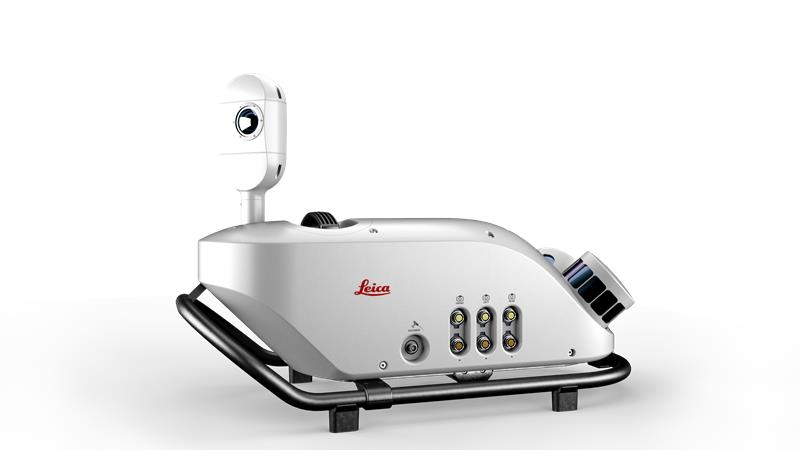
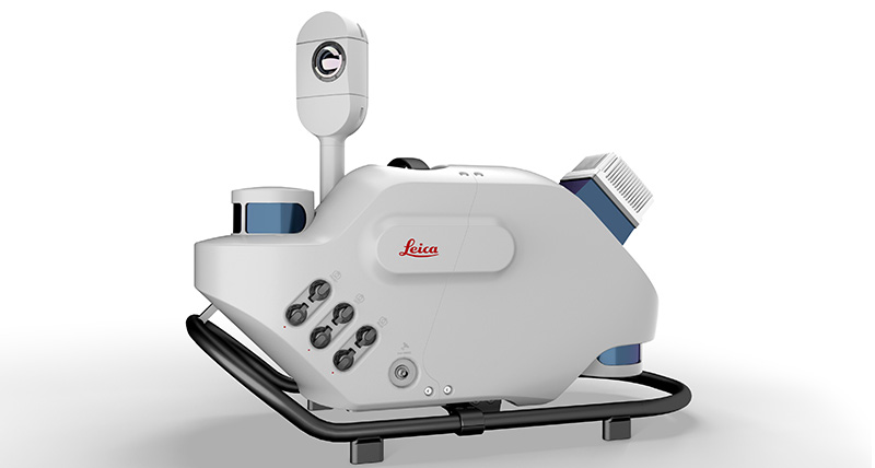
Leica Geosystems, part of Hexagon, has released an addition to its Leica Pegasus TRK portfolio of mobile mapping solutions, the Leica Pegasus TRK100. The mobile mapping system is a geospatial solution built for large-scale infrastructure measurement and digital twin creation.
The Pegasus TRK100 is small and light, making it easy to mount on any vehicle. The mobile mapping system features the same modular hardware approach that enables users to add more cameras to expand the range of use cases.
Image: Leica Geosystems
With its advanced mapping capabilities, the Pegasus TRK100 enables GIS professionals to visualize and understand the location of assets to help make the right decisions, improve asset management, and support infrastructure building and maintenance. The Pegasus TRK100 combines artificial intelligence and a learning algorithm to enhance and optimize the clarity of points in post-processing for improved accuracy.
The versatility of the Pegasus TRK100 suits a variety of applications in diverse industries, including telecommunications, utilities and road maintenance.
“The Leica Pegasus TRK100 advances autonomy and artificial intelligence in mobile mapping, removing manual process steps and providing actionable insights for informed decision,” Christian Schäfer, business director mobile mapping at Leica Geosystems, said. “It empowers GIS professionals to create the maps they need, collect the information they require, and visualize the data in a way that immediately aids understanding.”
Industry experts noted in our November 2022 issue that heavy equipment autonomy may be a distant future. However, the steady innovation in machine-control technology to get there is yielding substantial value. To drill deeper into those technologies, we interviewed additional industry experts with a focus on the key role of GNSS in such systems.
1D, 2D and 3D
There is currently a sharp growth in the adoption of 3D systems, according to Jordan Van Wie, product specialist with SANY America, a prominent manufacturer of construction equipment. “The fact is that many jobs are requiring this. They’re more efficient in their bidding process. They know exactly where they need to cut and where to fill — this means being more productive in less time.”
SANY America is based in Peachtree City, Georgia, where many of its construction equipment systems are manufactured, including the SY225C, a popular medium excavator.
The process of automating to the levels the operators desire is a matter of which sensors are added and how they sense the active geometry of the equipment in use.
For an excavator, SANY installs four sensors, then measures the machine, said Mukesh Selvaraj, product manager, medium and large excavators, SANY America.
“We know the distance between the bucket pin and the stick pin, up through the boom, and the angles on the sensors. We can compute in the system and report where the tip of the bucket is in relation to the body, and construct a 3D model in real time. This reporting can be as fast as 200 Hz.”
Among the machine-control systems implemented on SANY construction equipment are those from Hexagon | Leica Geosystems. Leica produces precision guidance and control sensors and systems for construction, agriculture and mining that are integrated onto various heavy equipment brands.
While 3D is becoming more popular, systems need to be scalable. Hexagon | Leica Geosystems has variants for different levels of guidance and automation, said Kert Parker, U.S. channel development manager for the company.
“For instance, if you start with our PowerDigger Lite, it has a control box, a display, a boom sensor, an angle sensor for the stick (which includes a laser catcher) and a 360° bucket sensor. This lets you know where the bucket tip is in relation to the model — call it a 1D system.” The cost of such a system might only be 5% or 10% of the cost of the machine on which it is installed — a modest investment for the productivity gains it can deliver.
To upgrade and run automatics, users could add a machine control panel and docking station with just 2D software. “That will give you a semi-automatic solution even on 2D. Then you can upgrade and add the GNSS receiver and antenna — or antennas — and 3D software to make it 3D, semi-automatic,” Parker said.
Two-thirds of the price of the base system is for the sensors on the boom, stick, bucket, the pitch and roll sensor, and the wires that communicate throughout the system, Parker explained.
“So, it’s completely scalable. You can start with a low-cost system upgrade to do GNSS fully and semi-automatic. We can automate any pilot-controlled machine, then we set the pressure. And when we sense the stick pressure, if the system is going automatic, then we automate the boom and the bucket.”
Third ‘D’ Options
“When you’re using something to give the machine a northing, an easting and a height at all times — that is when it becomes full 3D,” Parker said.
3D systems can be configured with a single GNSS receiver, with dual GNSS receivers, or off of a robotic total station. “The only difference between single and dual is that, with single, every time you move the machine you have to do a calibration swing, about 90° to get your heading again.”
“You can dig curves and complex designs working in 2D,” Van Wie said. “But every time you move the machine, you have to re-bench to a known reference, either by pinching with a bucket’s teeth, or hit the stick sensor that has an incorporated laser catcher. When you move the machine, you catch the laser beam again, and you use that for your known reference to dig back from the 3D model.”
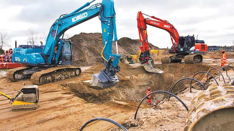
Excavators are a high-growth class of heavy equipment for machine-control adoption, with many excavators ready for system integration. Shown here, Leica iCON iXe3 systems on a Kobelco SK210 (left) and Hitachi 300-02 (right). (Image: Hexagon | Leica Geosystems)
For certain operations — such as excavating in a straight line or moving materials to the side —higher levels of automation may not be needed, so some users appreciate the option of starting with a cheaper system.
“For the small operator, of course, but even for a large operator, it’s a big investment to go full 3D,” Van Wie said. “They don’t want to go full 3D right away, or not on all equipment at once. They start off with just the basics and get familiar with it. Then when they want to upgrade, they have some of the stuff that they’re going to need for their machine already on it.”
System Examples
eSurvey GNSS manufactures GNSS-based equipment, software and systems for surveying, mapping, agriculture, UAV and construction. Better known in other global markets than in North America, the company has seen a steady rise in the market for construction automation — outpacing other sectors utilizing heavy equipment automation such as agriculture and mining combined. For construction, in many parts of the world excavators are the prime focus for automation.
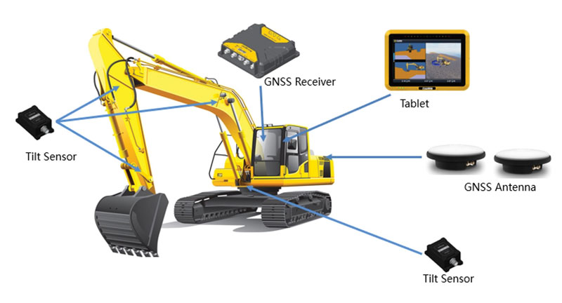
Figure 1. A common configuration of sensors for excavators: GNSS receiver, dual antennas, control tablet and tilt sensors on the body, boom, stick and bucket.(Image: eSurvey GNSS)
Their eME10 system for excavators includes a dual-antenna GNSS receiver, three single-axis tilt sensors, one dual-axis tilt sensor, a tablet and software (Figure 1). “The eME10 does not support a rotating bucket at this time,” said Edward Zhang, product manager for machine control technology. “We support standard excavators, excavators that reach into the water (for instance on dredging barges), and with different bucket tools such as quartering hammers and milling tools.”
Another popular system for compactors is the eMC10, with a single-antenna GNSS receiver, tablet and software, and optional temperature and vibration sensors.
Managing Positioning
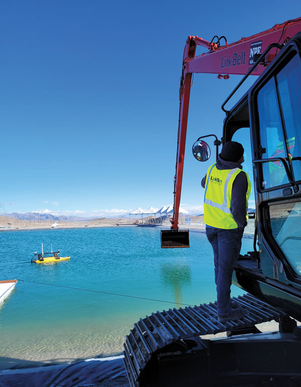
Both the excavator and hydro survey boT have dual GNSS antennas for position and orientation, ensuring fidelity between the 3D model and operation of the excavator for dredging. (Image: Gavin Schrock)
High-precision GNSS, as implemented for architecture, engineering and construction (AEC) applications, can yield centimeter-grade results. However, as many AEC professionals and practitioners know, achieving repeatable and consistent results requires an experienced and skilled GNSS operator. Is the operator examining the results for statistical consistency? How have the observations been constrained to the desired reference framework? Have sources of error such as multipath and space weather been considered?
However, Nick Fifarek, general manager at SITECH Pacific LLC, a construction technology provider, said that equipment operators only need to learn the user interface.
“They are mostly concerned with how the grade is shown in the model, and what actions are required to meet the grade. They should not need to be concerned with the working of the GNSS receiver.”
A larger firm with multiple systems will usually have a technician or surveyor on board, Fifarek explained. This expert would have the experience needed to set up a GNSS site base, ensure corrections are received, and troubleshoot causes of anomalies and poor results.
To be efficient, an operator should not have to deal with a complex set-up.
“It should be more like Google maps in your car,” Fifarek said. “They do not need to know how the model was created, and how the GNSS delivers positions to the interface. All the sensors should work seamlessly, like tilt sensor and IMUs [inertial measurement units] and how they work together with the GNSS to put positions on the blade or bucket. Once this is all working well and the model is applied, they should just be able to take directions.”
Nevertheless, sometimes this expert will need coaching, or a small firm may not have an expert at hand.
“We may need to teach them about some fundamentals, such as signal-to-noise ratio, PDOP [positional dilution of precision], and other quality indicators — especially when setting up the site base station,” Fifarek said.
Additionally, he pointed out, the control must be set up — this is mostly done by engineering or surveying firms along with site calibrations — and operators need to know how to check it.
Multipath Issues. Fifarek has not experienced problems with short masts for GNSS antennas, saying that the height of the cab is sufficient. Modern multi-constellation receivers, have improved multipath mitigation, and are able to work in sites with limited sky view or obstructions. Equipment such as excavators and dozers typically have dual-antenna GNSS systems, or two receivers and antennas. This provides not only position, but orientation and heading. These are usually installed on the body or cab, although some systems have a GNSS antenna on each end of the blade. Some systems use a method that only fixes one of the antennas/receivers, and then performs a fixed baseline solution for orientation.
The Chain of Components
Much like autonomy in vehicles, machine control implementation can be defined as various levels.
Level 1: GNSS-assisted guidance. The most basic level of implementation provides the equipment’s location and heading. It acts the same way as a navigation device or phone in your car. The technology has been around for decades for precision agriculture and construction. Level 2: Implement Control. Control of the blade or bucket. Level 3: Assist. Implement control plus a level of automation where the operator moves the control stick to initiate an action the machine completes by moving the blade or bucket to meet the design model geometry. This can include steering for various types of equipment. Level 4: Autonomy. More on that later.
The power of tilt-compensated GNSS+IMU smart antennas may be the key to reducing the number and complexity of synchronizing a “chain of sensors.” In this example, a Trimble R780 smart antenna has been added to the stick of an excavator. (Image: Trimble)
For levels 2 through 4, continuously updating a position on the blade or bucket requires a chain of sensors to work in tightly controlled harmony. An excavator could be equipped with one or two GNSS receivers and antennas and a tilt sensor on the body, explained Geoffrey Kirk, product manager, autonomy and assist for Trimble. The GNSS will provide the position and orientation of the body, or rotating section of the body, on an excavator, and the tilt sensor reads how level it is. Another option is positioning with a total station and prism on the body, such as when GNSS is not available. “Either way, you need to know where you are in 3D space to be able to work on any 3D model,” Kirk said. “Today there are usually about 30 satellites in view. We can do so much more now compared to the days when we had fewer satellites, things that would have been impractical,” Kirk continued.
Sensors on the boom, stick and bucket can be likened to an upper arm (boom), forearm (stick) and hand (bucket), with rotating buckets acting like a wrist.
“We put a six-degrees-of-freedom IMU at each of these locations,” Kirk said. This is a chain of highly dependent geometry extended out to the bucket. However, Kirk said there may be a better way.
Reducing the Links
In recent years, a new technology has been implemented for GNSS smart antennas (rovers), like those that surveyors and grade checkers use, which tightly couples IMUs and movement of the GNSS antenna for calibration-free tilt compensation. Examples include the Trimble R12i (for surveying) and R780 (for construction), Leica GS19 T, and many more — few high-precision rovers made today lack tilt compensation. The observed acceleration and direction of the antenna adds orientation to the tilt angle (from the onboard tilt sensors), so the position of the tip of the survey rod can be computed precisely and in real time.
At the Bauma construction trade fair held in November 2022 in Munich, Germany, Trimble gave participants a peek at something new: putting a tilt-compensating GNSS smart antenna out on the stick of an excavator.
“With current systems, every time you hit one of those joints on an excavator, you need to understand what it is doing, calculating angles along the way,” Kirk said. “By mounting a tilt-compensated GNSS receiver on the stick, this becomes a lot easier to do.” Such innovations dovetail well with another trend in construction equipment: a move from purely hydraulic steering to drive-by-wire. This trend makes for more simplified and often less costly processes for adding implement control and automatics, but may also be key in implementing autonomy.
The Path Toward Automation
“One of the big changes in the industry is understanding what tasks operators are trying to do, so that we can help them do those tasks,” said Kirk. “We want to help people be more productive. We know autonomy is a thing. We’re actively working on autonomy; it’s going to be a while. In the interim, we want to make sure that we are providing value to the manual operators for the tasks that we can’t do autonomously.”
Key foundational components of what would go into autonomous systems are already in place.
“With automatics, you already have implement control, and in some implementations, you even have steering,” Kirk said. “What is missing in terms of the mechanics is speed control — that may be the easy part.” Adding the crucial situational awareness, other sensors for feedback, and the brains for automation is what might take a lot of time to work out.
“Autonomy for cars is where you are trying to avoid hitting things,” said Kirk. “For construction, we are in the business of hitting piles of dirt and spreading them around.” For a car, the sensors see something, recognize it, know how far away it is, and can issue such commands as “stop” or “slow down” — which is not so simple for construction.
Three key technologies you’ll see being used for situational awareness are radars, cameras and lidar, mostly used in combination. “Radars have some really nice behaviors,” explained Kirk, but cautioned that they cannot tell what they are doing.
A demonstration implementation of an autonomous excavator.(Image: Trimble)
For instance, adaptive cruise control in cars, which is nearly always done with radar, works very well and reliably. Most such radars are now solid state and safety certified. Unfortunately, he points out, while radar is very good at alerting drivers that there is something in front of them, it is not very good at telling them what it is.
“That’s why developers put in cameras, so that you can see whether what’s in front of you is a person, another vehicle, or something else. That’s why you have those combinations of sensors.”
One of the reasons it will take longer to automate construction, Kirk explained, is that operators need to know much more about the nature of other objects in the construction environment than cars do on the road. The operators need to know not only what people, equipment and materials are around them, but also whether there is something or someone standing in front or on top of the pile of dirt.
“For situational awareness, you need to be able to do real-time mapping,” Kirk said. “Lidar and cameras, such as stereographic cameras, can be used as classifiers. Lidar can have limitations, such as when driving directly into the sun.”
“The smarts for autonomy are knowing what the task is and how to perform that task,” Kirk said. “However, from the standpoint of a machine’s sensor and setup, we’re not controlling speed, though we do on agricultural machines. So, machines are matched really well for autonomy — you can make them do whatever you want today.”
Examples of autonomous conduction systems were demonstrated in the off-site “sandbox” exhibit of Trimble Dimensions+ held in November 2002 in Las Vegas. There was an autonomous excavator, a compactor and a remote-control dozer.
Yet these were operating in a controlled environment. Kirk said that for safety reasons, early adoptions of autonomy might be confined to sites that are not along roads and highways.
The BLK2FLY, recognized for its productivity and innovation, is a fully integrated autonomous flying laser scanner. It’s part of Hexagon’s BLK suite of autonomous reality capture sensors designed for speed, portability, ease-of-use and mobility.
To compile the list, TIME solicited nominations from TIME’s editors and correspondents around the world, and through an online application process, paying special attention to growing fields — such as the electric vehicle industry, green energy and the metaverse. TIME then evaluated each contender on key factors including originality, efficacy, ambition and impact.
“Having our reality capture technology recognized by TIME as one of the year’s best inventions is both humbling and inspiring. It validates our mission to build Smart Digital Realities that empower an autonomous, sustainable future,” said Hexagon President and CEO Ola Rollén. “Our technologies aim to change the world for the better, turning concepts that were once thought impossible into real solutions that benefit everyone. By optimizing quality, productivity, efficiency and safety — profitably — we can help industry achieve sustainability through mitigated risk, less waste and reduced cost.”
As a lidar-based unmanned aerial vehicle (UAV), the BLK2FLY addresses costly and complex issues, quickly and accurately capturing everything from large outdoor spaces to complex structures and environments.
For example, when renovating building structures, it can easily capture the exterior dimensions of previously inaccessible or difficult-to-reach areas such as rooftops and facades. The resulting colorized 3D point clouds are instrumental in building information modeling (BIM) processes, documenting site conditions and improving an asset’s operation, from infrastructure to utilities to industrial facilities.
Leica Geosystems, part of Hexagon, has launched of Leica iCON gps 160 — a significantly enhanced, next-generation construction smart antenna with features that increase productivity in all stakeout and measurement applications on the jobsite.
The Leica iCON construction portfolio offers a broad range of smart antennas to fit every construction professional’s needs. From basic level to sophisticated high-end applications, Leica Geosystems’ smart antennas are designed and built to withstand challenging site conditions. All of them seamlessly integrate with all Leica iCON construction instruments and controllers as well as the iCON field software for precise, real-time verification.
To expand its portfolio of smart antennas, Leica Geosystems has launched the iCON gps 160, a versatile solution for various applications. It can be used as a base station, as a rover or for machine guidance. The Leica iCON gps 160 is a modernization and enhancement of the successful Leica iCON gps 60, which has been well accepted in the market. The result is a smaller, more compact GNSS antenna with additional features and a larger display for ease of use.
The new Leica iCON gps 160 is particularly suited to complex construction environments with different GNSS requirements — the ability to switch between the different applications is at the users’ fingertips. Besides checking grade, cut and fill, stakeout points and lines, users can also benefit from using this solution for basic-level GNSS machine guidance.
Construction technology must be easy to adopt. Thus, the iCON gps 160 comes with an integrated color display, a user-friendly interface, smart setup wizards and an intuitive construction-specific workflow to help contractors get the most out of their investment from day one.
Size and weight reductions make the iCON gps 160 easy to handle, while the latest GNSS and communication technologies improve data reception, resulting in increased productivity and efficiency.
Photo: Leica Geosystems
The optional tilt feature allows users to measure and stake out points with a tilted pole, which saves time and extends the measurement possibilities on any construction site.
“At Leica Geosystems, we understand that construction surveyors are under pressure and tight schedules to provide accurate, on-demand data that helps deliver projects on time and on budget,” said Matthias Schmidt, manager, Portfolio Field and GNSS, Leica Geosystems. “The iCON gps 160 Smart Antenna sets new standards in construction GNSS antennas. It solves several challenges simultaneously, enabling precise measurement, avoiding mistakes and extra trips on-site, ultimately helping to work toward a more sustainable future.”
Leica Geosystems, a part of Hexagon, received the prestigious Wichmann Innovations Award at this year’s Intergeo in Essen, Germany, for its Leica AP20 AutoPole.
The Wichmann Innovations Award honors new technology that stands out for innovation, user-friendliness and practicality. A panel of industry leaders shortlisted the submissions. Subsequently, the public was able to weigh in by casting a vote for their favorite finalist.
The Leica AP20 AutoPole is an innovative solution for automated total stations that features tilt compensation, automatic pole height readings and unique target identification. The technological convergence in the AP20 addresses core pain points in today’s total station workflows by making it possible to measure with a tilted pole, adjust height readings in the software automatically and prevent the station from locking onto unwanted targets.
Photo: Leica Geosystems
“The Leica AP20 AutoPole boosts efficiency by removing the last analog steps in robotic total station workflows. We were pleased when customers told us they were able to double their productivity on some projects,” says Hans-Martin Zogg, business director TPS at Leica Geosystems, part of Hexagon. “This award represents the acknowledgment of the expert jury as well as the broader surveying community, and winning it is a wonderful recognition of our team’s accomplishment.”
The average age of surveyors in the United States is nearly that of retirement. Can new technology attract a new generation to the profession?
“We do not fully understand the trend in the United States,” said Simon Peng, ComNav Technology, “but in China we find that modern survey technology — such as UAV/lidar mapping and total stations — make field work simple. New trends such as computer imaging, point clouds and building information models (BIM) attract young surveying engineers.”
Using the equipment in the field is becoming increasingly easier, said Bernhard Richter, Leica Geosystems. “Our goal is that operating the field equipment should not be more difficult than playing with your smartphone. That means that you don’t need the super expert in the field so much anymore.” However, he argued, “someone who studied surveying should now be more the data manager, have the expertise to put the data in geospatial relation, and know in which reference frame he is operating.”
For example, that person needs to know about orthometric and ellipsoidal heights, especially for engineering projects between countries that might have different height codes. “Anybody who has an interest to geolocate an object can capture the data and upload it to the cloud environment,” Richter said. “Then there are the data managers. Certainly, they need to know the physical limits of surveying technology, and they need to manage the complexity of modeling Earth. They need to become data managers to really put data to work.”
“The anticipated number of new professionals is not necessarily replacing all the surveyors who are expected to retire over the next 10 years,” said Boris Skopljak, Trimble. To tackle this challenge Trimble is using a two-pronged approach: attracting younger workers by raising awareness of surveying as a future career and modernization of the profession. For the first prong, Skopljak cited “phenomenal programs out there, such as Get Kids into Survey.” He pointed out that many Trimble employees are part of those education programs, “promoting inclusion of not just a younger generation, but also of women and minority groups that are heavily underrepresented in our industry today.”
For the second prong, “Digital data capture workflows present opportunities. A very common interview question we ask these days is ‘Do you play video games?’ Generally, those young professionals who are gamers thrive in the 3D environment. The technology aligns well with the interests of younger folks.”
Additionally, a growing number of educational institutions are evolving their curriculums to meet these needs, said Skopljak. Trimble is establishing Trimble Technology Labs in selected academic institutions around the world that are helping students access the latest technology and the best modern engineering practices. Boosting productivity also helps compensate for the declining number of surveyors, because it reduces the number of people needed to get the job done. “As the technology becomes easier to digest and operate and more focused on the workflows, it also becomes easier for companies to standardize it and attract talent,” Skopljak said.
One of the biggest threats to the survey profession, according to Huff, is that it “let bits and pieces of traditional surveys fall off to the wayside.” Geographic information systems (GIS) use the same positioning technology, he pointed out. “Fifty years ago, that was more of a function of the surveyor than it was necessarily the GIS profession. In many ways, while the surveyor is aging — the licensed cadastral surveyors certainly are aging — there is a new generation of folks coming through who are leveraging the new technology, such as drones and mobile mapping systems.”
This new generation, Huff argued, will achieve the same accuracies as the previous one partly because it’s getting easier to do so. “We definitely have more of a generation of digital users that can leverage the technology to do things where even my mentors performed many calculations by hand, on the fly, from plain tables in their logbooks with sine, cosine and tangent in them. Now, I think that technology and 3D immersive technology, which hinges on GPS location, attracts a younger crowd to certain facets of the profession.”
François Freulon, Septentrio, agreed that new technologies now available “can be easily adopted by new generations in the profession,” yet added that “quality surveying requires a good formation and experience in the field.” Therefore, he argued, “surveying education systems will need to adapt their programs and incorporate newer techniques such as new positioning modes and corrections.
Surely RTK remains as the main accuracy technique, but this could change quickly in the coming years as correction services bring better performance and regional coverage.”
Advances in GNSS technology constantly expand the range of projects that benefit from them.
ComNav Technology
A telecom company adopted its CORS station to build China’s national CORS service for public companies. It is increasingly used for field robotics, including the development of self-driving cars.
Leica Geosystems
Bernhard Richter, vice president of Geomatics, Leica Geosystems AG, pointed to one of the biggest infrastructure projects in Europe, which aims to connect London to Birmingham, Manchester and Leeds with a high-speed railway system, avoiding the need to fly between those cities. This will have great environmental benefits because high-speed trains are much more efficient than planes.
However, high-speed rail requires tremendous precision. “First comes the prep work, moving dirt,” said Richter. “Then you must install the railroad ties with tenths of a millimeter precision relative to each other to avoid side accelerations. For a surveyor, it really has everything in one project. You need to constantly work with civil engineers. You then try to build as much as possible with machine-control-guided systems to make the leveling as automated as possible.” The project will include building bridges over whole valleys and monitoring them, particularly during the construction phase, to ensure that they are not moving.
“Even the factory they are building is huge, so just to build the factory you need a lot of surveying,” Richter said. The project is generating 25,000 jobs at 300 construction sites, all of which must be managed on very tight schedules. In this context, the quality of the survey gear is critical. “On a construction site, the surveyor should be an invisible person,” Richter said. “When they come with the big machines and want to get stuff done, they don’t want a surveyor on the site. So, he has to work off hours, then remain on alert and trust that what comes out of an instrument is correct.” Leica Geosystems is one of the main suppliers for this project. “They chose us because of our focus on reliability, trust and quality.”
Trimble
Software is increasingly driving sales, pointed out Boris Skopljak, vice president, Surveying & Mapping Strategy and Product Marketing at Trimble Inc. As an example, he cited Trimble’s SX12 scanning total station, which uses Trimble Access software to leverage scanning, imaging and traditional total station capabilities in the field. “We have provided more inspection tools to enable people to decide whether something is meeting the tolerance.” The Trimble Connect cloud-based collaboration platform, coupled with the continuous field and office connectivity, has driven productivity increases and moved customers toward choosing the company’s solutions, he said.
As an example of Trimble solutions, Skopljak cited City Rail Link, New Zealand’s first underground rail network and the largest transportation infrastructure project ever undertaken there. “The Trimble R10 was integral to acquiring static observations above the work site, while the Trimble S9, DiNi and Trimble Business Center network adjustment were game changers for the survey control network,” he said. To expedite mine tunneling the surveyors used the SX12’s combined total station and scanning functionality with Trimble Access field software infield inspection tools. “Fewer customers are choosing solutions on a spec. It’s not about how many satellites you can track, for how many days, or how many points you can scan. They are choosing solutions based on the ecosystem and productivity.”
Land surveying is an ancient practice, dating back at least 5,000 years to when Egyptian rulers used it to tax land plots. Over the centuries, it has been repeatedly transformed by new technologies — the compass (about 200 B.C), the theodolite (1550s), Gunter’s chain (1620), the sextant (1757), electronic distance measurement (1950s), and total stations (1970s). Then came GPS, followed by the other GNSS and corrections services.
Now comes sensor fusion, which aims to compensate for the limitations of GNSS — orbit and satellite clock errors, ionospheric and tropospheric delays, multipath, dilution of precision, urban canyons, jamming, extremely weak received signal, etc. — by integrating it with other sources of positioning data, including inertial measurement units (IMUs), lidar sensors and cameras. Even crowdsourced geolocation data collected with cell phones help expedite surveys by guiding surveyors to landmarks.
In the following article, representatives of five companies share their perspectives on recent advances in surveying and the remaining challenges.
Many More Satellites
City Rail Link is New Zealand’s first underground rail network and the largest transportation project ever undertaken there. In this photo, taken at Karangahape Station, the Mined Tunnel Team installs a lattice girder secondary support structure using a Trimble SX12. (Photo: Link Alliance)
Compared to just a few years ago, there are many more GNSS satellites, signals and options for correction services. Over the past decade, the average number of satellites in view has more than doubled to more than 40 today. Some parts of the world have more than 70 satellites in view, said Boris Skopljak, vice president, Surveying & Mapping Strategy and Product Marketing at Trimble Inc.
“The developments in GNSS field systems have always been geared toward simplifying workflows, improving accuracies and increasing productivity,” Skopljak said. “In the last few years, we’ve seen that on a massive scale. In some of our materials, we no longer even quote how many signals our GNSS receivers are tracking.”
The vast increase in the number of satellites has extended high-precision applications to the robotics and automotive markets. The challenge now is “position solution,” not just GNSS, said Simon Peng, director of the Overseas Department at ComNav Technology. The improvements in the satellite constellations, antenna technologies and algorithms also enable surveyors and other users to obtain results faster and to operate in environments previously impervious to GNSS, such as under heavy canopy and very close to buildings.
“Our customers can now operate in environments where there is no virtual reference station (VRS) infrastructure or real-time kinematic (RTK), by leveraging precise point positioning (PPP) solutions, such as the Trimble RTX corrections service,” Skopljak said.
“Additional satellite signals and constellations (like Beidou),” Skopljak said, “improved antenna technology and continuously evolving algorithms are contributing to improving the RTX accuracy while bringing the convergence times to almost instantaneous in normal conditions and making technology available in more regions.”
“When I first started surveying, if we had a 12-channel receiver, that was doing very well,” recalled Jesse Huff, head of Sales and Marketing, JAVAD GNSS. “Now, we’re tracking 36 birds in the sky at one time with an 874-channel receiver. That’s phenomenal.”
Huff described a patent-pending feature called real-time post-processed kinematic (RTPK). “It combines RTK, PPK and PP techniques, with multiple core processing engines and a single solution coming out of that. It is impressive standing underneath a giant oak tree and surveying that monument with GPS and knowing what your accuracies are. We’re not even chasing RMS values; we can report the actual positional uncertainties, which is amazing.”
Pole tilt compensation enables surveyors to precisely and easily localize points that are difficult or dangerous to access. (Photo: ComNav Technology Ltd.)
“With so many signals and the new ways of how we compute positions based on PPP technology, we can almost globally get to centimeter-level positioning within a couple of minutes from just one global correction link,” said Bernhard Richter, vice president of Geomatics at Leica Geosystems AG, part of Hexagon. “Under optimum conditions, you can have almost an instantaneous global accuracy of a couple of centimeters.” In mature areas, he added, a local RTK network infrastructure enables achieving centimeter accuracy within a couple of seconds.
Galileo, Richter pointed out, will be fully operational in 2023 with great signals, though he’s “a bit skeptical” about the system’s target date for its high-accuracy service. “So, we will basically get global constellation corrections that allow us also centimeter-level positioning.” BeiDou has been fully operational since 2020. “GLONASS is more unpredictable,” Richter said. “It looks like modernization is slowing down a bit, in particular the CDMA developments.” Additionally, he pointed out, it is possible that one or more governments may decide not to use those signals, for military or political reasons. “It’s not the manufacturers who decide which signals to take.”
“In open-sky conditions, additional satellites have added redundancy — which is always good for position integrity — but it’s only when obstacles start to appear on the horizon, blocking out parts of the sky, that all-in-view RTK really comes into its own,” said François Freulon, Head of Product Management at Septentrio. When they did not have a full view of the sky, he recalled, GNSS users used to have to carefully schedule their work to coincide with times of high satellite visibility. “Nowadays, by using multiple constellations and signals, RTK can reach the parts that receivers in the past could not tread. More signals and constellations have also helped in easing the collection workflow for surveyors, making the capture of data in difficult conditions much quicker and more efficient.” New correction services are further simplifying the workflow “thanks to new positioning techniques, pricing business models and simplified network density.” However, corrections companies still face challenges in ensuring that centimeter accuracy can be uniformly achievable at a global scale.
Sensor Fusion
The ongoing evolution in computing power and communication technology “leads to many more sensor combinations,” Skopljak said. “We are not talking about GNSS alone anymore. We are talking about integrating a GNSS antenna, a receiver, an IMU, power and communications into a single compact housing.” The integration of inertial sensors makes it possible to localize the instrument rod tip when the pole instrument is tilted. “That allows our customers to measure more safely in dangerous environments.”
“We are reaching a maturity stage of what we can do only with GNSS,” said Richter. “It’s all about sensor fusion. The problem when signals are obstructed, that’s not solved, even though we can do positioning from Wi-Fi hotspots or from local pseudolites.” So, fusing data from cameras, lidar, GNSS and IMUs in better ways is the way to go and presents “a huge open research ground.”
For Richter, the challenge is not just positioning, the orientation of objects is almost as important as that, especially for such tasks as machine control. “It’s also about what you do with the data that you collect. Hexagon’s vision is of an autonomous future where we put data to work in connected ecosystems to boost efficiency.” However, he pointed out, this requires large amounts of data, such as those from aerial photogrammetry, lidar and mobile mapping systems used to create city models and digital twins of buildings. “If you really want a car to drive autonomously through a city with all the things that could happen, you must rely on a perfect replication of the real world,” he said. Other examples he cited are more efficient evacuation plans and flooding simulations. “GNSS will never be enough, but it will always be a very good enabler because it works.”
Classes of Receivers
JAVAD GNSS designed its TRIUMPH-LS Plus receiver to work under heavy tree canopy. (Photo: JAVAD GNSS)
Two decades ago, we would often group GNSS receivers by accuracy into three buckets: consumer grade, resource or mapping grade, and survey grade. As accuracy has increased for all GNSS receivers, the boundaries between those categories — especially between mapping and surveying — have blurred. “The performance of GNSS has increased so much that we are not using the traditional accuracy-based differentiation between surveying and GIS,” said Skopljak. “For mapping professionals, 10 years ago it was all about points, lines and polygons; now it is all about locating assets and adding the most accurate positions as attributes to those assets. For our survey and engineering customers, what matters is still geometry and working with the models to serve the connected construction in the field.” As for the pure GNSS technology stack, “we are seeing fewer differences between mapping and surveying receivers, but we are focusing on serving the customer in terms of product-as-a-service or as a productivity tool.”
Huff made two points. First, that “survey grade” does not necessarily equal RTK. “Some education needs to happen so that people understand RTK as a technique, not an accuracy. You can get poor accuracy and poor fixes with RTK, even when you’re using good techniques. So, when I say ‘survey grade’ I’m still talking about the full frequency receivers, using all available signals.” Second, that consumer-grade receivers, such as the chipsets in our phones and computers, do not require the same robustness as professional ones. “While they may be achieving the same precision, surveyors must be able to defend their position in a court of law.”
Huff cited the “phenomenal” success of the simultaneous localization and mapping (SLAM) movement with all kinds of positioning challenges. “From a survey perspective,” he said, “we’re dealing with a much more feature-rich dataset than we were even just 10 years ago, with everybody having some type of GPS device on their phones. There are location tags on everything. That creates evidence for the surveyor to be able to go out and recreate things, reduce trips to the field, reduce rework times — all those things that make a surveyor’s life much easier.”
Surveyors now can fly aerial surveys of hundreds of acres in less than half an hour using drones with RTK, Huff said, instead of having to wait for the flying season with traditional airborne photos. If needed, they can pick a few ground-control points for ground truthing. “We’re able to do that with photogrammetry techniques, but using GNSS technology to position drones, whether it’s real time or post-processing, has definitely made surveying jobs easier.”
Correction Services
The adoption of GNSS in construction is growing and receiver manufacturers are making it easier to use their equipment in the field. (Photo: Leica Geosystems)
Correction services — such as satellite-based augmentation systems (SBAS), the ground-based Wide Area Augmentation System (WAAS) and the European Geostationary Navigation Overlay Service (EGNOS) — make a big difference along with PPP and similar techniques when base stations are not available. “We have the whole CORS network here in the United States,” Huff pointed out. “We also have services available from the National Geodetic Survey.”
Those who don’t want to have to fully engage in post-processing can upload their data to the Online Positioning User Service (OPUS), AUSPOS (a free online GPS data-processing facility provided by Geoscience Australia) or other corrections services that will post-process positioning data. “It has made it more accessible for all the surveyors all the way around, especially as the technology has improved and the cost barrier to entry into a survey-grade GPS receiver has come down significantly as well,” Huff said.
Growing Adoption of GNSS
The greater number of satellites in orbit significantly reduces convergence time and increases the accuracy of the solution, which makes the technology much more user-friendly for professionals and nonprofessionals alike.
For surveyors and mapping professionals, the increasing levels of GNSS performance means that “GNSS continues to be the dominant equipment and they can operate in challenging GNSS environments while still meeting the accuracy and precision requirements,” Skopljak said. GNSS usage is also growing in such industries as agriculture, construction, transportation and logistics. “Now, when farmers are on a combine, they don’t have to wait for an RTX or PPP solution to converge for 20 minutes. The solutions just work, and they can perform their task.”
Skopljak also pointed to “more flexible business models, such as pay-as-you-go or equipping seasonal workers or fleets of spatially enabled consumers to use GNSS,” that reduce the required upfront investment. “Surveyors now can go for longer and be productive in more areas where they could not use GNSS technology before. The non-surveying professionals — such as in natural resources, farming or construction — now can just turn on the machine and things work for them. They don’t have to worry about coordinate transformations and things like that.”
“Twenty years ago, when RTK and networks kicked in and then became popular, we were discussing whether it was the end of the automated total station,” Richter recalled. “Yet, the number of automated total stations has grown ever since.” To him, this is proof that GNSS alone will never solve all surveying problems. GNSS’ weak signal will always require surveyors to supplement it with other sensors, such as reflectorless total stations. “These instruments always need to work in harmony,” Richter said.
Success on both construction sites and in machine control require a very good robotic total station and a very good GNSS receiver, Richter said. “The simple problem of leveling a pole is actually solved, and we are using the technology that we developed for tilt-compensating GNSS receivers. We’re leveraging this now into the world of the total station.” This has solved one of the fundamental problems surveyors have long had, because they no longer need to level up and can measure tilted poles with a total station and with a GNSS receiver. “We have also made it very seamless for surveyors to switch between using GNSS receivers and total stations,” Richter said.
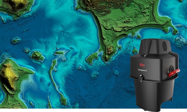
The new Leica Chiroptera-5 is a high-performance airborne bathymetric lidar sensor for coastal and inland water surveys.
Offered by Leica Geosystems, Chiroptera-5 provides 40% higher point density, a 20% increase in water-depth penetration, and improved topographic sensitivity for generating more detailed hydrographic maps.
The technology increases the depth penetration, point density and topographic sensitivity of the sensor compared to previous generations. It delivers high-resolution lidar data supporting applications such as nautical charting, coastal infrastructure planning, environmental monitoring and landslide and erosion risk assessments.
Chiroptera-5 combines airborne bathymetric and topographic lidar sensors with a four-band camera to collect seamless data from the seabed to land. With a higher pulse repetition frequency (PRF), the new technology increases point density by 40% compared to the previous generation system, collecting more data during every survey flight.
Improved electronics and optics increase water-depth penetration by 20% and double the hydrographic sensitivity to capture larger areas of submerged terrain and objects with greater detail. The high-performance sensor is designed to fit a stabilizing mount, enabling more efficient area coverage, which decreases operational costs and carbon footprint of mapping projects.
Leica Geosystems’ signature bathymetric workflow supports the sensor’s performance. Introducing near real-time data processing enables coverage analysis immediately after landing, allowing operators to quality control the data quickly before demobilizing the system.
The Leica Lidar Survey Studio (LSS) processing suite provides full waveform analysis and offers automatic calibration, refraction correction and data classification, as well as advanced turbid water enhancement.
Supporting environmental research
Combining superior resolution, depth penetration and topographic sensitivity, Chiroptera-5 provides substantial benefits for various environmental applications such as shoreline erosion monitoring, flood simulation and prevention, and benthic habitat classification.
Bundled with the FAAS/EASA-certified helicopter pod, the system enables advanced terrain-following flying paths for efficient river mapping and complex coastlines surveys. Owners of previous-generation systems are offered an easy upgrade path to Chiroptera-5 to add capabilities to their existing sensor and leverage their initial investment.
“The first-generation Chiroptera airborne sensor was flown in 2012. During its 10 years of operation, the system has seen constant evolution that continuously improved the productivity and efficiency of the entire bathymetric surveying industry,” said Anders Ekelund, vice president of airborne bathymetry at Hexagon. “By collecting detailed data of coastal areas and inland waters, Chiroptera-5 provides an invaluable source of information that supports better decision making, especially for environmental monitoring and management, in line with Hexagon’s commitment to a more sustainable future.”
Leica Geosystems, part of Hexagon, has introduced Leica Pegasus TRK, a reality-capture mobile-mapping system that features artificial intelligence (AI), autonomous workflows and intuitive interfaces.
The Pegasus TRK features an AI-enhanced camera and automatic camera calibration. To comply with privacy regulations, its AI can identify and blur identifiers, such as people and vehicles, in real time.
Features include advanced dynamic laser scanning and an expandable imagery system for recording, measuring and visualizing environments. It also increases productivity with automated, intelligent workflows.
Light enough to be operated by one person, the Pegasus TRK is user-friendly, able to be used by professionals new to the technology. Its reliable, high-quality deliverables serve the needs of technical experts in various industries, including surveying, transportation and utilities.
The Pegasus TRK solution enables long-range mobile mapping for applications in asset management; road construction; rail and critical infrastructure; oil, gas and electricity industries and more. The system also is suitable for creating high-definition base maps for autonomous vehicles.
The Pegasus TRK connects with the new powerful Leica Pegasus FIELD software for fully autonomous and secure data collection and route planning in the field. It also connects with Leica Cyclone Pegasus OFFICE for seamless input into post-processing and publishing workflows.
“The Pegasus TRK solution is the most efficient mobile mapping product we’ve tried so far,” said Raymon Somford, CEO and owner of Rise3D. “It is lightweight and easy to use, guiding our team through the process of data collection. Its sensors that trigger automatically avoid missing details. We can achieve quality images regardless of the conditions, making mobile mapping almost effortless.”
“The Pegasus TRK solution offers flexibility, true-to-life image clarity and best-in-class accuracy while making mobile mapping more accessible and easier than ever before,” said Christian Schäfer, business director, Mobile Mapping at Leica Geosystems. “There is a growing demand for more autonomy. This solution raises the bar in data collection with automated route planning, guidance and collection processes that increase efficiency, improve data quality and reduce project costs.”
The Pegasus TRK will be a featured Tech Highlight at Hexagon’s flagship digital-reality solutions conference HxGN Live Global in Las Vegas, which takes place June 20-23.
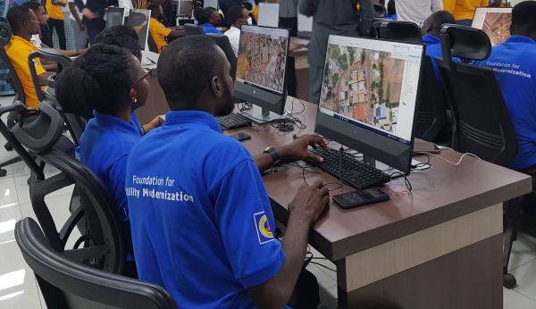
Hexagon’s Safety, Infrastructure & Geospatial division successfully deployed an advanced utility geographic enterprise asset management (EAM) system for the Electricity Company of Ghana (ECG). The smart EAM, featuring Hexagon’s G/Technology, will allow ECG to plan, manage and efficiently operate its distribution network to meet the growing needs of 4.5 million customers.
The enterprise system from Hexagon unifies data from a variety of geographic information systems (GIS), enabling bi-directional data flow with other systems based on the Common Information Model (CIM) standard. The system enhances ECG’s ability to geographically reference and manage assets with integrated tools for data surveying, capture and maintenance and network planning and calculation.
Mobile capabilities enable efficient inspections and maintenance, while a web portal assists employees with locating assets, reviewing the network and more. Migrating to Hexagon’s system will increase process efficiency and reduce asset-management costs by harmonizing systems, validating existing data and capturing missing data.
“The utility GIS is the critical component that fuels innovation in the utility,” said Keli Gadzekpo, board chairman of ECG. “This project is the foundation and the first step to modernizing ECG operations. It is the platform for digitization of electrical network assets, a prerequisite for bringing efficiency in the wire business.”
Photo: Hexagon
Part of ECG’s Modernizing Utility Operations Activity, the project was commissioned by Millennium Development Authority (MiDA), Ghana, on behalf of the Government of Ghana’s Millennium Challenge Account Entity Program and funded by the U.S. government.
“We are exceedingly grateful to Hexagon for working tirelessly to deliver this innovative product,” said Julius K. Kpekpena, Ag CEO and COO, Millennium Development Authority. “The technology sets Ghana’s biggest electric distribution utility on the path to modernizing its operations. The GIS is the foundation for modern tools to help ECG plan its networks, reduce losses, collect revenues and serve customers more efficiently.”
The project included procurement and installation of system software, server hardware, mobile field units and services for data migration by Hexagon, field validation of assets by PDSA Ghana (part of Hexagon), and production of aerial imagery by ILV Wagner using Hexagon’s Leica Geosystems surveying and airborne imaging technologies.
“Reliable electricity requires accurate data and tools to plan, design and manage networks, which can also reduce overall maintenance costs,” said Maximillian Weber, senior vice president, Global Utilities & Communications, Hexagon’s Safety, Infrastructure & Geospatial division. “We are proud to support Electricity Company of Ghana in delivering quality service to its customers.”
Leica Geosystems, part of Hexagon, has introduced the Leica AP20 AutoPole — a solution for automated total stations that boosts productivity with tilt compensation, automatic pole-height readings and unique target identification.
The AP20 AutoPole combines an intelligent sensor module with the new AP Reflector Pole and operates with Leica Geosystems’ existing automated total stations to create a solution for autonomous workflows.
It is designed to solve three workflow challenges:
holding the pole vertical and stable
entering the pole height manually into the field software
locking to a foreign target on a site with multiple reflectors.
The tilt compensation of the AP20 AutoPole increases efficiency when working with total stations. It is no longer necessary to level the pole for measurements and stakeout. Tilt compensation decreases measurement time and increases flexibility and safety on site by enabling the measuring of points in locations that are inaccessible or put the user at risk. By updating the pole height automatically in the field software, the system ensures that the height on record is always correct, which avoids errors, time-consuming postprocessing and returning to the field to remeasure.
Additionally, the AP20 AutoPole’s target identification ensures the user’s instrument will always lock to the correct target.
“At Leica Geosystems, we understand that tight time schedules, growing expectations for accurate on-demand data and budget constraints put a lot of pressure on surveyors and construction professionals,” said Hans-Martin Zogg, business director, Total Stations, Leica Geosystems. “The AP20 AutoPole is a game changer because it solves several challenges simultaneously. Its tilt compensation and automatic pole height readings are absolutely unique in the industry and will transform how professionals measure with total stations.“
“As a surveying company, the only way we can stay competitive and profitable is to acquire spatial data simply, quickly and efficiently,” said Clifton Webb, director of Warner Surveys. “The Leica AP20 helps us stay ahead of the curve by increasing our productivity and flexibility. It allows us to measure points that were impractical or unsafe to measure before.”