Verizon will integrate TomTom’s Maps application programming interfaces (API) and software development kits (SDK) into its location-services offering, making it easier for the developer community to build upon and integrate the platform. The developers’ portal is available at developer.tomtom.com. More information from
The agreement is an expansion of the existing TomTom and Verizon agreement, where TomTom provides location-based services to enhance Verizon’s current suite of location-based data, navigation, and intelligence.
“We look forward to continuing to build upon and evolve our product suite with TomTom’s technology,” said Jeff Frantz, executive director, Verizon Location Services. “By expanding our agreement, we are furthering our commitment to providing best-in-breed location technology for Verizon and our customers.”
“We’re determined to make it as easy as possible for developers to have access to our Maps APIs and SDKs so we’re delighted that Verizon is offering TomTom products to their location-services customers,” said Anders Truelsen, managing director, TomTom Enterprise.
5G and HD Maps. In the last quarter of 2019, the companies also announced an innovation project using Verizon 5G Ultra Wideband and TomTom HD Maps to help make intersections safer for emergency vehicles.
Woolpert has received the 2019 Google Cloud Specialization Partner of the Year award for location-based services.
Woolpert was recognized for the company’s achievements in the Google Cloud ecosystem, helping joint customers deploy and optimize their location-based services, developing an online customer assistance system and cloud information portal, more than doubling its staff to support customer needs and supporting all location-based data efforts with its extended geospatial team.
The firm, which has been a Google Cloud Partner since 2015, was awarded this honor and the Google Cloud Partner Award for Customer Success in Google Maps Platform in 2018. Woolpert Vice President and Chief Innovation Officer Jon Downey said Woolpert is honored to work with Google Cloud and provide a heightened level of products and services to the teams’ joint customers.
“We thought this would be a natural partnership, joining the world leader in customer-facing location-based services with one of the first global geospatial mapping firms, but it has far exceeded our expectations,” Downey said. “It has given us the ability to create products and provide support specific to our clients’ location-based needs, which has led to a greater than 98% retention rate and more than 100 additional customers in 2019. We look forward to what this partnership will yield in the future.”
“We’re proud to recognize Woolpert’s work on behalf of customers,” said Carolee Gearhart, vice president, Worldwide Channel Sales at Google Cloud. “Woolpert has demonstrated strong expertise and results in providing location-based services for customers over the past year, and we look forward to continuing our partnership to help customers succeed.”
Altair Semiconductor integrates Polte’s Cloud Location over Cellular (C-LoC) technology with Altair’s ALT1250 dual-mode CAT-M& NB-IoT chipset.
Photo: Altair
Polte Corp. and Altair Semiconductor have collaborated to integrate Polte’s cellular-based location technology with Altair’s ALT1250 cellular Internet of Things (IoT) chipset.
The ALT1250 is Altair’s dual-mode CAT-M & NB-IoT solution, a small, highly integrated cellular IoT chipset with ultra-low power consumption, GNSS location positioning, a hardware-based security framework and an RF front-end supporting all commercial LTE bands.
Enabling miniature module sizes of less than 100 square millimeters, the ALT1250 is suitable for a range of industrial and commercial IoT applications.
Polte’s patented location-as-a-service (LaaS) solution leverages ubiquitous 4G and 5G cellular networks and cloud computing to enable highly accurate location data indoors and outdoors.
Business processes, customer self-service automation, and better decision making insights enable consumer, commercial and industrial businesses to capitalize on location.
“With the explosive demand for smaller and low powered IoT devices, Polte’s C-LoC technology is a great complement to the integrated GPS and GNSS capabilities of our dual-mode ALT1250 chipset,” said Oded Melamed, CEO of Altair Semiconductor.
“Location is a key function in numerous IoT applications, such as smart meters, telematics and trackers, where low power and small form factor are crucial,” Melamed said. “We look forward to the opportunity of working with Polte to offer our customers the best solutions to meet their needs.”
“Polte is poised to disrupt the location services market. As more and more IoT use cases demand indoor, outdoor and everywhere in between location, Polte’s software-only solution embedded on Altair’s dual mode ALT1250 chipset delivers location services — at lower cost, using less battery, more securely,” said Polte CEO Ed Chao. “We are excited about the opportunity to bring the power of Polte’s location services platform to Altair’s leading Cellular IoT chipset.”
Testing the antenna performance of GNSS signals such as GPS, GLONASS, Beidou, Galileo and Metropolitan Beacon Systems (MBS) is key to location accuracy performance of a mobile device.
To address the testing need for A-GNSS services, Rohde & Schwarz and Bluetest are partnering in creating test concepts for over-the-air (OTA) antenna measurements.
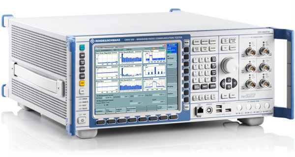
The CMW500 wideband radio communication tester. (Photo: Rohde & Schwarz)
The two companies integrate the R&S LBS Server, a software component running on the R&S CMW500 wideband radio communication tester, and the Bluetest OTA test solution for A-GNSS systems based on Bluetest’s RTS65 reverberation chamber and Bluetest’s Flow measurement software.
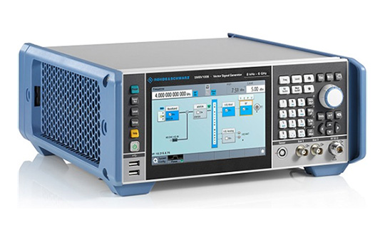
In the test setup, the R&S LBS Server controls the Rohde & Schwarz base-station simulator R&S CMW500 for LTE, WCDMA and GSM, and uses the R&S SMBV100B vector signal generator for simulation of GNSS and MBS signals.
A simple and straightforward upgrade of the setup for 5G will be available soon, making sure that investments are protected and most relevant standards can be tested with the same system.
The R&S LBS Server is an essential part of the R&S TS8991 OTA Performance Test System. This cooperation between Rohde & Schwarz and Bluetest marks the first time that the R&S LBS Server, used here as a software tool on R&S CMW500, is available also for third parties.
“We are delighted to collaborate with Bluetest to contribute with our test and measurement expertise to OTA 4G/3G/GSM and GNSS technology development,” said Alexander Pabst, vice president, Systems and Projects at Rohde & Schwarz. “With a strong global footprint for location based services LBS and close cooperation with partners, Rohde & Schwarz is committed to accompanying the evolution path from OTA testing for GPS, GLONASS, BeiDou and Galileo with innovative test and measurement solutions.”
“The addition of A-GNSS measurements means that the full range of wireless technology in a modern cellular device can be verified with just one test solution,” said Robert Rehammar, Bluetest CTO. “Bluetest has enjoyed the close cooperation with Rohde & Schwarz on this project, leading to a very strong joint solution and customer offering.”
Enhancements include flexible pricing and easier app deployment experience
Esri has implemented major changes to ArcGIS for Developers, providing an enhanced mapping experience that the company says is more accessible and affordable.
These changes include a new pay-as-you-go plan for all of Esri’s location-based services, a decrease in the price of routing transactions and a new commercial app deployment experience for developers, the company said.
ArcGIS for Developers. (Photo: Esri)
This new experience brings the power of mapping to all developers and provides greater simplicity and flexibility. Esri has introduced a new monthly payment structure for the Builder plan in its developer subscription. The Builder plan is now offered at a monthly subscription rate of $125.
Esri has also introduced a 10 percent discount on existing annual Builder plan subscriptions. Customers who currently have an annual Builder plan subscription can continue to pay annually or switch to paying monthly.
“In addition to our existing subscription plans, we have introduced a new pay-as-you-go model that enables developers to pay only for services and transactions that they use,” said David Cardella, Esri product manager for developer technologies. “Developers can now access dozens of different maps from our Living Atlas, store their data securely, route, and geocode, as well as create and deploy apps with much greater ease and efficiency.”
Esri has additionally included a commercial app deployment license in all paid developer subscription plans (Builder plan and higher) at no additional cost. The price of routing services has also been reduced from $4 to $0.50 per 1,000 routes. This price decrease is applicable to all ArcGIS users, including the developer community.
ArcGIS for Developers offers a full suite of developer tools and development resources to build mapping and analytics solutions to support business needs. Developers use ArcGIS APIs to create location-based web and native applications for desktop and mobile devices.
The new enhancements and changes now give developers greater freedom to build, manage, and deploy apps as quickly as possible by allowing them to use the specific tools they need, when they need them, priced to fit their individual needs.
Rohde & Schwarz’s Stefan Maier gives GPS World an overview of the company’s progress on its E911 location-based services test system at ION GNSS+ 2018 in Miami.
Comtech Telecommunications Corp.’s Enterprise Technologies group has been awarded a $10.1 million multi-year contract from a major U.S. mobile network operator for its hosted, advanced location-services platform. The order includes development, deployment and support.
The Comtech platform leverages its Position Determining Engine to deliver precise location information of devices for applications such as turn-by-turn navigation, family finder and remote workforce management.
Secure and completely standards-based, the solution is hosted outside the operator’s network and ensures interoperability across all device providers, the company said.
“Network operators require their location services platform to be reliable, accurate, scalable and secure – and we have delivered on all fronts,” said Fred Kornberg, president and CEO of Comtech Telecommunications. “We are honored to be chosen by this customer and believe that this agreement again validates our industry-leading expertise in deploying advanced location services.”
Comtech Telecommunications designs, develops, produces and markets innovative products, systems and services for advanced communications solutions. The company sells products to a diverse customer base in the global commercial and government communications markets.
“The blockchain cannot be described just as a revolution. It is a tsunami-like phenomenon, slowly advancing and gradually enveloping everything along its way by the force of its progression.” — William Mougayar *
A kidnapping in Kiev
War-torn and ragged, the once glistening jewel on the Dnieper River adorned in Christmas lights bustled with Yuletide celebration. But further from the city center, the streets were quieter, more demure as the dark night settled in. A black Mercedes Benz pulled up and parked along a poorly lit street. In the car sat four men wearing facemasks and carrying Kalashnikovs. In the cold Kiev night, they waited.
Across the street a large, husky man pulled shut the security curtain, turned out the lights and locked the front door of his store. He turned, his briefcase hanging at his side, and walked a few steps toward his car.
The four men crossed the dim street, forming a semi-circle as they moved toward the man. He slowly raised his hands. He was Russian; his accent gave him away. One of the four men placed a thick black bag over the Russian’s head. With gun barrels pointed into his back, he followed their orders, climbing into the back of the Mercedes Benz.
The four men got into the car and sped away into the cold, dark Kiev night. The man was Pavel Lerner, a blockchain expert and owner of a digital currency exchange in the Ukrainian capital. His captors demanded a ransom of $1,000,000 paid in Bitcoins, the highest valued cryptocurrency.
Three days later, on Dec. 29, 2017, safe and unharmed, Pavel’s abductors released him along an unmarked road in the middle of nowhere.
Cryptocurrencies and crime. Crimes involving cryptocurrencies have been increasing; perhaps the most widespread is hackers using ransomware demanding payment in Bitcoins. The worldwide WannaCry virus is the most pernicious of these attacks, costing hundreds of billions of dollars.
Other crimes of the more traditional variety are also on the rise such as kidnapping, as in the case of Chloe Ayling, a British glamour model held for $500,000 payable in Bitcoin.
Blackmail and money laundering are also on the rise; all of them are using Bitcoin as the currency of choice, as are black markets lurking on the darknet.
The fall of the dark web marketplace Silk Road netted unexpected surprises, capturing two rogue FBI Agents and a DEA agent found to be peddling in the underworld’s vast enterprise. Silk Road’s net worth when it was shut down was 614,305 Bitcoins.
As December 2017 came to a close and Pavel Lerner paid his ransom, the value of one Bitcoin peaked at $19,843, making Silk Road worth $12.2 billion and the Dread Pirate Roberts the second wealthiest criminal in history. Ross Ulbricht, the creator of Silk Road, is serving a life sentence.
The 2015 documentary Deep Web describes the government’s takedown of Silk Road. View the trailer below.
When currencies fail
Governments have always been slow to act, or at least slow to comprehend. Such is the case with cryptocurrencies. The government sees the phenomenon as a mechanism supporting criminal enterprise, but the trending use in digital currencies represents a seismic shift in the way people think about money and where they are placing their trust.
There is a decline in the faith of fiat currencies as the countries backing them fall into mounting debt. Concern is fueled by the instability of national and international politics and the threat to the U.S. dollar by the unraveling of the petrodollar.
As well, the euro has been hit by wave after wave of bad news by the economies of Greece, Italy and Portugal and the so-called Brexit, as the United Kingdom withdraws from the European Union. What does that spell for the future of the euro?
Plus, with sanctions, Russia’s Ruble has lost 50% of its value since 2013. The farcical worthlessness of a Zimbabwe 50 trillion dollar note proves there is no limit to the loss in value a fiat currency can suffer when it implodes.
Photo: iStock
Venezuela’s currency collapse. And now, Venezuela is in a plummeting currency death spiral, officially falling in value from a par of 10 Bolivars to equal one U.S. dollar to 25,000 bolivars, all in the month of February. Unofficial reports are that the value has sunk to 230,000 bolivars to the U.S. dollar.
As of Tuesday, Feb. 27, in a desperate attempt to salvage itself, Venezuela announced an initial coin offering (ICO) for a national cryptocurrency called the petro. The irony in this is that the digital currency will probably survive because it’s on the blockchain, but Venezuela will not.
If anyone wants to learn about what happens when a nation’s currency collapses, Venezuela is a terrifying case study. It is no wonder people around the world seek refuge in an asset that promises freedom from government meddling. It is also no wonder governments are terrified of blockchain’s potential, yet fascinated at the same time, like so many other technologies holding great power for both good and evil.
There is a stalemate of sorts, a stand-off between those early adopters with the courage to invest and risk it all for the hope of great fortunes, and governments who hold the power to regulate, fine, confiscate and imprison. Tension separates both sides. Who will budge?
The United States and Europe have so far been measured in their response, while China and South Korea are cracking down on cryptocurrencies. Most people, curious and cautious, sit waiting it out. These stories represent the darker side of bitcoin, blockchain and the rise of cryptocurrencies, but there is another side, the more benevolent, useful and hopeful side.
What are cryptocurrencies?
Unlike gold, which has traditionally been considered a store of value, cryptocurrencies have no physical existence. They are digital assets held in a digital wallet. They are an asset with a finite number of tokens. They are driven purely by supply and demand. If there is a greater supply than there are traders, the value is next to nothing as there was in 2009 when Bitcoin first came into existence.
May 22, 2010, marks the milestone when a digital currency first purchased something in the physical world. Two pizzas sold for 10,000 Bitcoins. Now, there are more traders than tokens, and the demand has driven the value to unprecedented heights. One Bitcoin was worth $19,499 on Dec. 15, 2017.
Bitcoin is the most explosive financial instrument ever created. But Bitcoin is not the only digital currency. In all, there are more than 1,800 cryptocurrencies. The term “crypto” implies they are secretive and have a layer of anonymity, but there is an irony. Cryptocurrencies are based on blockchain technology.
Blockchains have an unalterable integrity system built into them, leading to the adage “What happens on the blockchain stays on the blockchain.” That creates a conundrum and begs the question, just how is it that what provides a veil of secrecy also holds the promise of open transparency?
Blockchains
Image: iStock
To answer that question, we need to explore blockchains. What exactly is a blockchain? A blockchain is a digital, decentralized, distributed, open and immutable ledger. Each transaction has a string of characters called a hash. Each hash includes a date/time stamp, a unique ID, a code linking it to the previous hash, and a private key identifying ownership, albeit anonymously.
Each transaction is another link in a chain that can be traced backwards to the previous link, all the way back to the origin of the entire chain, called the Genesis Block.
What makes the blockchain decentralized is no single computer or entity controls it. Hundreds and thousands of computers make up a blockchain network. Each computer is called a node. A blockchain is distributed because all the nodes work together in a peer-to-peer network. Nodes on a network record each transaction, and these transactions are mirrored on every other node throughout the network.
The transactions can be accessed and downloaded from any node on the network. This makes a blockchain an open and distributed ledger. When a node is out of sync with other nodes on the network, it is rejected until it is reset to match the other nodes. That makes it impossible to alter any records, making a blockchain immutable.
For these reasons integrity, is built into the blockchain. Anonymity is provided by a private key that ties it to a digital wallet that can only be accessed by the owner. The digital wallet connects to the owner, but not the blockchain itself. As a result, a blockchain identifies what, when and who about each transaction. A blockchain does not provide where the transaction occurred.
At this time, blockchains lack a geospatial capability.
“Anytime there’s some data that needs to maintain its integrity, blockchain is definitely there. Essentially, what you would do is get the hash and you would have a hash key and then any changes or alterations are made fully aware at all times.” — Reem El Seed **
Geospatial blockchain benefits
Image: FOAM
A company called FOAM is working to change that, creating a geospatially enabled blockchain using a crypto-spatial coordinate (CSC) system. Location in a FOAM blockchain doesn’t just record a specific time, it also validates proof of location and gives a spatial context that regular blockchains lack.
This functionality creates an immutable digital connection to the physical world. Kristoffer Josefsson, CTO of FOAM Inc., confirms this, saying, “We can securely connect offline spaces to online assets.”
If digital currencies based on blockchain technology are going to be considered a safe and viable medium for conducting business, they must include location. Blockchain’s abilities are what the world needs to curtail crime and corruption and be able to follow the money trail from whom and to where it flows.
“This is what we are working on at FOAM and believe that such a system is needed as a crucial infrastructure in our decentralized future and can open new marketplaces of privacy preserving location data.” — John Ryan King, CEO, FOAM Inc.
Adding a geotag to a blockchain is like adding ribonucleic acid to a cell bringing it to life. Something can’t exist until it exists in time and space. A blockchain with a geospatial tag makes that possible and allows mapping of events in a temporal sequence. This inhibits criminal activity.
If a crime were committed using a geotagged blockchain, the location of the crime would immediately be known. The hash code from the blockchain would be extracted with a date/time/location stamp and would be flagged on the network to all the nodes, making that hash code “hot.” A hot blockchain means that particular hash in the chain would be monitored. If it were involved in a transaction, an alert would be broadcast throughout the network, focusing on the location.
Security cameras and other assets would converge, putting eyes on the target, and the transaction would be rejected. Authorities would then be able to trace the digital wallet’s owner like running license-plate tags for a car, and, shortly thereafter, descend on and apprehend the offender.
Did George Orwell dream the dream we are now living, “Big Brother is watching you,” while he himself mocks us from his eternal sleep?
Empowerment with location. Mansour Raad, senior software engineer and Big Data advocate at Esri, sees location-enabled blockchain opening up opportunities for people to interact with their representatives. He is excited about the prospects saying, “We can envision dozens of potential use cases in geospatial contexts, from fine-grained citizen engagement in smart-city initiatives through to activity-based military intelligence applications.”
Certainly, this is a more empowering view. Some of the largest companies in the world are also exploring uses for blockchain and geospatially tagged ledgers. This mass effort and focus on innovation will have some magnificent results.
Mansour goes on to add, “The influx of companies like Boeing and Lockheed Martin and forward-thinking communities like Dubai are searching for blockchain-based solutions to their problems.” This will drive innovation. Both ends of the spectrum are there, from the frontline developers to the back-end buyers with large pockets.
Latitude and longitude has been the backbone of location and navigation for more than 2,000 years, when people navigated primarily by landmarks and the stars. That worked well for those not venturing beyond their familiar locales; but as knowledge of the world expanded and monarchs ruled larger and larger empires, and trade spread to further and further regions, and wars and conquest extended to unknown realms, maps were necessary. A grid system for maps was created by Hipparchus, another of those great Greeks upon whose shoulders the world still stands. That coordinate system, known as latitude and longitude, has served well for two millennia, but the digital age demands another solution.
And so it is with change. It happens over many years, but the transformation happens all at once. The change has been taking place for years with location-based formats such as the Military Grid Reference System (MGRS) and the more universal digital Degrees Minutes Seconds (DMS) supporting GPS-based systems, as well as the more novice friendly what3words (W3W), which is especially useful for disaster-relief operations. All of these serve their purpose, but fall short of providing a concise code that is critically important to make geotagging a blockchain possible. That is of great value considering blockchain’s potential in logistics and transportation, both of which are dependent upon precise location data.
Photo: Port of Rotterdam
Add the growth of IoT (the internet of things) and one gets a sense of the demand for a location-based blockchain and how enormous such a system would be. The Port of Rotterdam, Europe’s largest shipping facility, is testing blockchain for logistics. Companies like Ford, IBM and PwC also are looking at its potential.
Mansour Raad adds, “Some data scientists see a benefit to utilizing an addressed reference system such as the Open Geospatial Consortium Discrete Global Grid System (OGC DGGS), due to its holistic ability to fit into existing hashing algorithms. This also turns map algebra into map-set mathematics with drastic advantages to speed, computational resource usage and distribution.”
Get ready! Blockchain is a disruptive technology. It is so powerful that it is difficult to predict its impact, but it will touch everything.
“The old question ‘Is it in the database?’ will be replaced by ‘Is it on the blockchain?’” — William Mougaya
Governments will be more accountable to the people tracing where their expenses are actually going. The government could post an annual tax bill for each person online that could, in theory, show each taxpayer where each dollar was spent. This is an empowering new model for transparency.
A digital wallet is virtual, but it can be connected to the physical world through a smart key, like a SIM card. And, if the blockchain were geospatially enabled, it would create a layer of security preventing any use if the owner of the digital wallet were not nearby. That’s automatic two-step authentication.
A geospatially embedded blockchain could make that possible. Cash can transfer hands and no one is any wiser about where the money came from, but transfer a blockchain-based currency and the new owner is part of the permanent record.
Tough on crime. What would that do to crime? How would it affect blackmail, kidnapping, human trafficking? Perhaps the smart key is attached to the owner’s cellphone, or a smart watch, or a smart ring? Most likely it would be a smart chip implanted in the owner’s arm or thigh.
A smart chip implant. (Photo: Escape Alert, LLC)
The technology would also be useful for password tokens, building access security cards, passports, etc. It holds great promise for warding off theft and increasing security.
Uses for a blockchain extend beyond currency and are not necessarily associated with financial transactions. Transactions are events: a download is a transaction; clicks on a webpage are transactions; passing through a checkpoint is a transaction; an image capture is a transaction; IoT-triggered events are transactions; and electronically signing a document is a transaction. Blockchains can be coded into software to track downloads of digital copies such as songs, movies, audio, video, images, programs and documents. The obvious implications are copyright protection.
Blockchains can also provide information security for trade secrets, military secrets and even national secrets. Companies that contract to the government would be able to lock their trade secrets from hackers and spies by controlling digital copies with a blockchain. A geocoded blockchain could encrypt data outside of geospatially approved areas or if accessed by anyone other than approved private keys. The contents of secure packages could never fall into the wrong hands even if the package was intercepted. The encryption could not be unscrambled without being in the proximity of the smart key.
Additionally, every download would record what, when, who and where any attempts at access occurred. Blockchain technology also enables smart contracts such as medical records, land ownership records, shipping manifests and notaries. Blockchains can be made a part of physical inventory.
Geocoded-embedded blockchains make asset management more secure, restricting transactions to within specific locations. This would be beneficial in a store for controlling inventory, or at a facility for tracking movements of assets, whether the facility is a military installation, an industrial complex, a government facility, a school campus or a penitentiary. In the case of a penitentiary, the prisoners themselves can be tracked.
Closing Thoughts about Blockchain
“In a time of deceit, telling the truth is a revolutionary act.” ― George Orwell
Elections. In a free republic, the integrity of elections must be protected and made fully transparent. Geotagged blockchain election ballots would be an immutable record of the election. A little geospatial analysis could easily detect locations with multiple votes making it highly suspect for voter fraud. Add the requirement to have a private key associated with each voter and voter fraud would be eliminated.
One of the benefits would be eradicating the months of post-election bickering wasting time, tax dollars and sanity. It’s hard to argue with a transparent, decentralized, distributed and immutable ledger; so, no matter which side of the political divide someone is on, removing reasons for conflict should benefit everyone.
Immutable record. If you look at the non-stop news cycle about the government missing texts, missing emails, possible collusion, a dossier, possibly two, and who knew what, and when did they know it, all of that could be resolved with blockchain technology. An immutable record would make it nearly impossible for anything to come up missing, and a geospatially tagged blockchain would show exactly who knew, what they knew, and where they were when they learned it. Deception would be made much more difficult.
Blockchain has the potential to sterilize corruption in politics. The ideal for an open and transparent political system is worth holding on to.
Learn about blockchain, because it will become more and more prevalent in conversations, on television, in movies, and on the news. I hope this article helped shed some light on the technology and its future and the advantages of adding a geospatial component to a blockchain.
* William Mougayar is the Voltaire of the blockchain revolution. He applies his visionary intellect to the merits of a trust-based, information-sharing system prescribing it a cure against the ills of business, politics and society. Mougayar is stoking the coals of the digital transformation just as Voltaire helped light the torch of the French Revolution.
** Reem El Seed is the coordinator of the Blockchain Users Group for the Washington, DC Chapter. She is a prodigious and enthusiastic proponent of blockchain and cryptocurrencies and a well-known figure in the Washington, D.C., area.
By Changfeng Yang, Chief Architect of BeiDou Navigation Satellite System
Changfeng Yang
As one of the four major GNSS providers, the establishment of BeiDou Navigation Satellite System (BDS) has been steadily developed, following a three-step strategy. By around 2020, BDS will form a nominal space constellation consisting of 30 satellites, including three satellites in geostationary Earth orbit (GEO), three satellites in inclined geosynchronous satellite orbit (IGSO) and 24 satellites in medium Earth orbit (MEO). It will provide global users with open and high-quality services free of charge, including navigation, positioning, timing, short message communication, search and rescue and so on.
BDS is aimed at developing into a world-class global navigation satellite system, with innovative and advanced technologies, extraordinary user experience, international development and worldwide presence, which can provide fundamental time and space reference for national defense and economic-social development, and advance the progress of high-tech and IT industries.
BDS has initiated several innovative attempts in the fields of both international satellite navigation and domestic aerospace for the first time, and paved a unique development path of a satellite navigation system, with an eye on the state conditions and distinctive features. On Jan. 9, 2017, the BD-2 Project won the top National Scientific and Technological Progress Award. In 2017, BDS achieved fruitful results in the aspects of system construction, integrated applications and international development.
System Construction
Through upgrading and reconstructing the ground system, the service performance, stability and availability of the BD-2 constellation have been improved. To achieve user-oriented services, the updated Interface Control Document (ICD) for B1C and B2a open service signals (Version 2.1) was released in accordance with the constellation change.
The international GNSS Monitoring and Assessment System (iGMAS) has been built, consisting of eight domestic monitoring stations and 16 overseas stations, to monitor and assess the service performances of BDS, GPS, GLONASS and Galileo at real-time worldwide. It has taken all factors into consideration, including constellation status, signal-in-space, navigation message, service performance and high-precision products, and so on. According to its analysis results, the nominal positioning accuracy of the BD-2 system in the coverage area has been optimized from 10 meters to 8 meters.
Development of the BD-3 System. On Nov. 5, the first pair of the 24 BD-3 MEO satellites were successfully launched, while another pair is planned to be launched by the end of the year.
Liftoff of the first pair of the BD-3 MEO satellites on Nov. 5, 2017. (Credit: Xinhua)
The BD-3 satellites are equipped with B1C and B2a signals with optimized performance, which are compatible and interoperable with other GNSS signals. The interface control document of B1C and B2a signals (beta version) was released in September. The BD-3 satellites also adopt the higher-performance rubidium atomic clock with stability of E-14 and hydrogen atomic clock with stability of E-15. By utilizing new technologies, the signal-in-space (SIS) accuracy will be superior to 0.5 m; the position accuracy will be doubled or quadrupled, and reach 2.5 m to 5 m.
The BD-3 system will retain the short message communication service of its predecessors, and further enhance basic positioning, navigation and timing (PNT) service capabilities. Satellite-based augmentation system (SBAS) and search-and-rescue (SAR) services will be added and developed according to international standards.
After in-orbit tests and networking validation, the BD-3 satellites will be able to provide operational services, and accelerate the global coverage of BDS.
Ground-Based Augmentation. The Phase I construction of the BDS/GNSS ground-based augmentation system has been completed, consisting of 150 framework reference stations, 1,200 reference stations of higher density network, national data processing center, six industrial data-processing centers, and manufacturing of user terminals. This system has achieved basic service capabilities, and its service performance standard (version 1.0) has been released. Through integration with the internet, a cloud platform has been established to provide high-precision space-time information services, including real-time navigation services at meter-level and decimeter-level, as well as precise positioning services at centimeter-level and millimeter-level.
Satellite-Based Augmentation. Based on the International Civil Aviation Organization (ICAO) standards, system demonstration and validation work on the BeiDou Satellite-Based Augmentation System (BDSBAS) has been completed, and the technical status of the system has been confirmed in accordance of the next-generation SBAS Dual Frequency Multiple Constellation (DFMC) standards.
Integrated Applications
Currently, a great number of independent, self-controlled intellectual property rights on the fundamental BDS products have been achieved. World-class, advanced technologies have been developed. With the release of the first Chinese in-house developed meter-level fast positioning BDS chip, BDS applications have begun to embrace the era of meter-level positioning.
In 2017, the sales volume of BDS navigation chips and modules exceeded 50 million pieces, and that of high-precision surveying boards and navigation antenna captured 30% and 90% of market shares respectively. There are more than 14,000 enterprises (including more than 50 publicly listed companies), and more than 450,000 employees in China engaging in BDS-related business.
The annual output value of the publicly listed company in 2017 is more than RMB 50 billion (US $7.53 billion). The number of terminals produced by domestic enterprises surpasses 40 million pieces/sets. BDS has gained recognition from mainstream chip producers such as Qualcomm, Trimble, Hemisphere GNSS, Huawei, Samsung, u-blox, MTK, Broadcom, NovAtel and more, and the total number of terminals is estimated to surpass 300 million pieces or sets.
BDS continues to:
promote integrated applications and development of related industries;
bring GNSS high-precision services in combination with cloud computing, Internet of Things, big data and other technologies;
push forward the integration between BDS-related industries and high-end manufacturing, software, and integrated data industries.
BDS has been applied in the transportation, logistics, emergency rescue, marine fishing and other fields, which has greatly improved production efficiency, reduced resource consumption, and lowered pollution. For example, benefiting from the BDS applications in traffic management industry, the number of major accidents has decreased by 46.7%, and the death toll has been reduced by 48.9%. With BDS-based maritime applications, more than 10,000 lives have been saved.
BDS/GNSS augmentation services have been applied to precision agriculture, land mapping, monitoring on deformation and displacement of large-scale public facilities, and earthquake and geological hazard measurement and survey; the latter has provided important monitoring for public safety. As a result, the production of precision agriculture has increased by 5%, and the oil consumption by agricultural machinery has decreased by 10%. The time for surveying and mapping of national land is shortened from a few days to several seconds.
BDS has been fully put into mass applications. BDS-based navigation services have been adopted by various enterprises, such as Huawei, ZTE, Baidu, Autonavi, Alibaba, JD and others in the fields of manufacturing of mobile and smart terminals, location-based services (LBS), e-commerce, and so on. BDS-based LBS have been widely applied in the mass consumption sector and people’s livelihood, and many innovative applications have emerged, such as caring for seniors and children, shared vehicles, BDS-based logistics, and so on, which have been changing people’s lives and providing more convenience for the public.
International Development
At present, BDS has covered more than 50 countries and more than 3 billion people. BDS-related products have gained access to the markets of more than 70 countries and regions, more than 30 of which are along the (land-based) Belt and (maritime) Road (in line with the Belt and Road Initiative). Through joint applications with other compatible navigation satellite systems, BDS provides global users with diversified choices for better application experience.
Meanwhile, the iGMAS has contributed to the implementation of the Asia-Pacific Space Cooperation Organization project, iGMAS-International GNSS Service Pilot experimental project, and Sino-Russian monitoring and assessment cooperation, and has provided GNSS users with authentic third-party assessment results. China continuously pushes forward BDS to be recognized by the ICAO, International Maritime Organization (IMO), mobile communication standard Partnership Project and other organizations, to serve the world in line with international conventions.
In October, three PRN codes which are essential to the development of BDSBAS were assigned; the SBAS service provider identifier and UTC standard identifier have been assigned to BDSBAS by ICAO, which marks BDSBAS an official SBAS provider in the ICAO family, and lays the foundation for the follow-up construction of BDSBAS, as well as its provision of standard navigation services for the civil aviation sector.
In March, a multi-system (including GPS, BDS and GLONASS) ship-borne receiver standard was approved by the IMO. BDS has also been included in the PNT guidelines of maritime applications.
In the field of mobile communication, 26 technical standards that support the BDS positioning function have been adopted by the third- and fourth-generation mobile communication standard Partnership Projects.
Future Plans
BDS will keep improving its continuous stability and service accuracy. Two more BD-2 replacement satellites will be launched in 2018, ensuring its regional service performance will be remain stable and be enhanced.
Eighteen BD-3 MEO satellites and one BD-3 GEO satellite will be launched by around the end of 2018. Upon the deployment of those 19 satellites, BD-3 will possess the initial operational capability and serve the countries along the Belt and Road. The official version of ICD for B1C and B2a open service signals, as well as other system documents, will be released, in line with the operational status of BD-3 satellites, for the convenience of public applications.
In regard to augmentation systems, China plans to complete the construction of Phase II BDS/GNSS ground-based augmentation system in 2018, and advance the recognition of BDS-based high-precision services as public goods. In 2018, the first BDSBAS GEO satellite with the BDSBAS payload will be launched to start the deployment of the BDSBAS system.
In terms of applications and international development, China will give full play to the role of BDS in the integration procedure between industrialization and IT applications, to promote the development of information industry, adjustment and upgrading of industrial structure.
China will also strengthen the cooperation and communication with other navigation satellite system providers, carry out coordination under the framework of international organizations and multilateral platforms, improve the international development of BDS, provide better services for users along the Belt and Road, and expand BDS services to serve users worldwide.
RTX Fast reduces the convergence time — the duration needed to reach full precision accuracy — by up to 98 percent faster than other satellite-delivered correction services, Trimble said.
The service allows customers to realize horizontal positioning accuracy of better than 4 centimeters (1.5 inches) in as fast as one minute. With RTX Fast, farmers, surveyors, geographic information system (GIS) professionals and construction contractors can work faster, improve productivity, minimize input costs and reduce worker fatigue, Trimble added.
New RTX Fast services have recently launched in Switzerland, Slovakia, Northern Italy, Eastern Poland and the Southern regions of Saskatchewan and Manitoba.
In addition, Trimble has a 60 percent larger footprint in the Central U.S., including new coverage in Kentucky and Tennessee.
As the requirement for real-time, absolute positioning grows, Trimble is expanding its RTX Fast coverage to meet the demand both geographically and for the markets it serves, including new emerging applications in vehicle autonomy and location-based services.
The demand for real-time absolute positioning in driving applications continues to rise as Advanced Driver Assistance Systems mature and accuracy requirements become more stringent. RTX Fast provides the network enhancement necessary to deliver fast, high-accuracy RTX corrections for real-time positioning while on the road.
“Trimble RTX technology has been adding value to our core markets since its introduction in 2011. And, now we are demonstrating its capability in new applications such as autonomous driving solutions,” said Patricia Boothe, vice president of Trimble’s Advanced Positioning Division. “We are committed to expanding the reach, use and accessibility of Trimble RTX technology, reinforcing its position as a leading solution for improving GNSS performance.”
Rohde & Schwarz and MediaTek have successfully completed the verification of location-based services (LBS) in the U-plane and C-plane for Assisted Beidou (A-BeiDou), China’s GNSS satellite positioning system.
The R&S TS-LBS test solution allows mobile manufacturers, chipset manufacturers, test houses and network operators to verify chipsets and mobile devices in order to obtain permission to operate them in a particular network.
The successful A-BeiDou verification of the MediaTek device under test (DUT) using the Rohde & Schwarz test system marks an important milestone in the GNSS evolution of positioning and navigation. According to Rohde & Schwarz, this was the first time that the setup could be used to validate and verify a device for A-BeiDou location-based services.
The R&S TS LBS from Rohde & Schwarz is a test system for testing GNSS and network-based LBS. It consists of an R&S CMW500 as the base station simulator and an R&S SMBV100A GNSS simulator. The R&S CMW500 provides assistance data to the DUT and the R&S SMBV100A simulates the BeiDou satellites. The R&S TS-LBS test system can be used to obtain GCF and PTCRB certification as well as network operator-specific certification for chipsets and mobile devices.
“We are delighted to collaborate with MediaTek and to contribute our test and measurement expertise to the development of A-BeiDou location based services,” said Alexander Pabst, vice president of Systems and Projects within the Rohde & Schwarz Test & Measurement Division. “Rohde & Schwarz already has a strong global footprint with testing solutions for A-GNSS, such as A-GPS or A-GLONASS, and for OTDOA/eCID. Thanks to our close cooperation with our partners, Rohde & Schwarz is committed to accompanying the evolution from existing to new satellite systems such as A-BeiDou with our innovative test and measurement solutions.”
“MediaTek is committed to developing and testing the latest mobile technologies and standards to drive the industry forward,” said TL Lee, general manager of the Wireless Communications Business Unit at MediaTek. “We have worked closely with Rohde & Schwarz to develop and validate the test solution for A-BeiDou LBS, verifying the A-BeiDou proof-of-concept trial system based on the R&S TS-LBS and MediaTek DUT. This represents an exciting step forward in the evolution of LBS technology, enabling the mobile ecosystem to verify chipsets and mobile devices on the new LBS technology.”
U.K.-startup Focal Point Positioning has unveiled two new positioning technologies. S-GPS and D-Tail represent step changes in consumer GPS processing and smartphone indoor positioning, the company said.
S-GPS is a new signal processing, sensor fusion and machine learning scheme that dramatically improves the accuracy and availability of satellite-based positioning signals, the company said. The patent-pending S-GPS technology provides increased sensitivity and multipath mitigation capabilities that allow modern smartphones to maintain accurate GPS fixes deep indoors and in complex urban environments.
The improvements have the capability to address challenging navigation problems such as locating emergency mobile phone calls, navigating autonomous vehicles through dense urban environments, and improving consumer interaction with location-based services (LBS).
D-Tail is a human motion modeling system that can accurately track users in three dimensions using the inertial sensors in their smartphone or wearable devices. The result is a precise trace of the user’s motion, better than the detail and accuracy provided by dead-reckoning and Wi-Fi fingerprinting techniques. D-Tail is designed to improve the performance and accuracy of activity tracking apps and LBS analytics.
The company is starting to engage with chipset manufacturers to deploy the technologies in smartphones, according to founder and CEO Ramsey Faragher.