TeleCommunication Systems (TCS) has purchased location-based technology and intellectual property from Loctronix. TCS is integrating the newly acquired assets from Loctronix with its location solution portfolio. Combined, the location-based services (LBS) solutions will enable TCS to further develop indoor-location technology applications ranging from advertising and marketing to navigation and public safety, TCS said.
TCS specializes in secure and reliable wireless communications. The company’s patented solutions enable 9-1-1, commercial location-based services and deployable wireless infrastructure; cybersecurity; defense and aerospace components; and applications for mobile location-based services and messaging.
“Purchasing LBS technology and intellectual property from Loctronix not only adds to our already vast set of intellectual property rights for LBS, more importantly it underpins our continued commitment to further building out our advanced location product portfolio,” said Jay Whitehurst, TCS senior vice president and Commercial Software Group president. “In addition to expanding the breadth of our current location product offering, the Loctronix assets will provide clear differentiators in device location, and increase our market and revenue opportunities — both for commercial and public safety applications.”
“We have exciting news,” Loctronix announced on its website. “The global leader in Precise Device location, TeleCommunication Systems, Inc. (TCS) has integrated our assets with theirs. We have always said that our mission was to locate any device anywhere — indoors or outdoors. With our technology, TCS will now be able to do just that.”
TCS plans to roll out new solutions leveraging the Loctronix assets by year’s end.
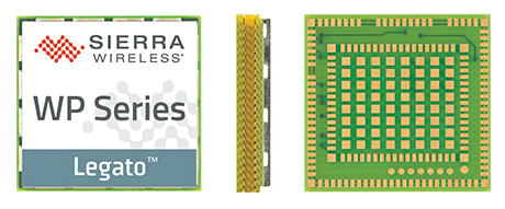
Sierra Wireless has introduced its next generation of the AirPrime WP Series of smart wireless modules for the development of connected products and applications for the Internet of Things. The WP Series provides an integrated device-to-cloud architecture enabling IoT developers to build a Linux-based product using a single module that sends valuable user and product data to the cloud.
AirPrime WP is part of Sierra’s new AirPrime smart portfolio, which includes:
AirPrime WP Series offering an application processor, GNSS receiver, and cellular modem with an optional ultra-low power mode that reduces power consumption by 200 times, opening up new use-case possibilities for cellular connectivity.
Legato Linux-based platform integrated directly into the application processor of the WP modules providing an open-source application framework and professionally maintained Linux distribution.
Project mangOH open hardware reference design for the WP modules offering wireless, sensor, and cloud connectivity out-of-the-box to rapidly build prototypes.
AirVantage cloud and connectivity services providing device, application, and connectivity management as well as an IoT data platform securely integrated into the WP.
“With the introduction of the new AirPrime WP Series modules, we have launched a powerfully integrated device-to-cloud architecture to make it easier for our customers to innovate,” said Dan Schieler, senior vice president, Embedded Solutions for Sierra Wireless. “With an application processor running the open source Legato platform, along with the AirVantage cloud for device and application management, and a new open hardware reference design, the latest WP Series modules enable developers to quickly build connected products using a single module to run all their applications.”
The WP Series is interchangeable and completely footprint-compatible with the AirPrime HL Series, and is available in 3G and 4G LTE variants with 2G fallback on certain modules. Like the HL Series, the new WP Series modules can be soldered down or used with a socket, for flexibility in manufacturing and inventory management. The form factor, called CF3 (common flexible form factor), will be supported by Sierra Wireless through multiple generations of both WP and HL Series product lines, providing a secure migration path for customers through multi-year deployments.
The next-generation AirPrime WP Series offers industry-leading ultra-low power mode for applications that need to prioritize power management over constant connectivity. This deep-sleep mode is designed for industrial solar- or battery-powered applications where constant connectivity is not required, opening up new use-cases for cellular connectivity where it was previously impractical.
For OEMs and developers, the integration of processors and device software with wireless functionality can be complex and time-consuming, even more so when modifications are required for each region and each generation of the product. If location-based services are required, a GNSS receiver must be integrated as well. Furthermore, the data from the wireless connection, the connected asset, and its location must be aggregated and delivered to enterprise applications.
The next-generation AirPrime WP Series is designed to address all of these issues. It offers an integrated processor and a GNSS receiver, reducing the number of components, integration time, and cost for developers. The Linux-based Legato platform running on the module’s processor provides the modem services needed to get the module communicating on a cellular network, plus an application framework and secured processing space to run third-party applications. Through Legato, AirPrime WP modules are pre-integrated with the AirVantage cloud for simple, secure configuration and management of the device and its data once deployed.
2015 GNSS Market Report: European GNSS Agency Provides a Fresh Look at Worldwide Growth
The fourth edition of the European GNSS Agency’s (GSA’s) GNSS Market Report provides a comprehensive source of knowledge on this dynamic global market. The report has become a key reference for organizations building their GNSS market strategies. The new edition provides:
Comprehensive updates on previous analyses;
New statistics of the GNSS receiver capabilities of the 31 top global manufacturers, offering in total more than 300 models;
Insights on the GNSS industry and regional shares of the GNSS market
A more granular segmentation of the global GNSS market, namely: European Union (EU28); North America (including the United States, Canada, Mexico); Asia-Pacific (including China, Japan, Australia, India, Republic of Korea); Non-EU28 Europe (Norway, Switzerland, Russia, Ukraine); Middle East and Africa (Turkey, Israel, South Africa, UAE, Saudi Arabia); South America and Caribbean (including Brazil, Argentina, Colombia, Guatemala)
Information on a new market segment: Timing and Synchronization
Plus additional applications within existing segments, such as recreational navigation, fishing vessels, personal locator beacons, emergency locator transmitters and digital tachograph.
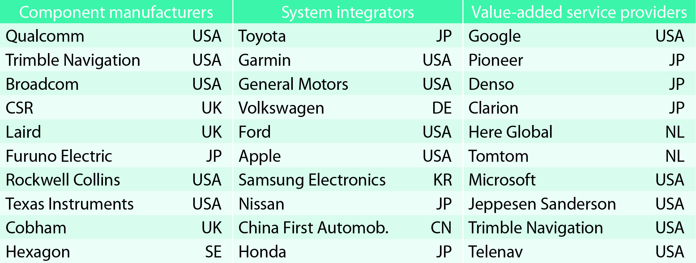
TABLE 1. Top 10 companies in each group based on 2012 revenue.
Key Findings
Top-line insights from the fourth GSA GNSS Market Report:
The global GNSS downstream market is forecast to increase by 8.3 percent annually from 2013– 2019, then slow down to 4.6 annually around 2023, growing on average faster (7 percent) than the forecast global GDP in this period (6.6 percent).
The installed base in the mature regions of EU28 and North America will grow steadily (8 percent per year) to 2023. The primary region of growth will be Asia-Pacific, which is forecast to grow 11 percent per year from 1.7 billion in 2014 to 4.2 billion devices in 2023 — more than the EU and North America together. The Middle East and Africa will grow at the fastest rate (19 percent per year), but starting from a lower base.
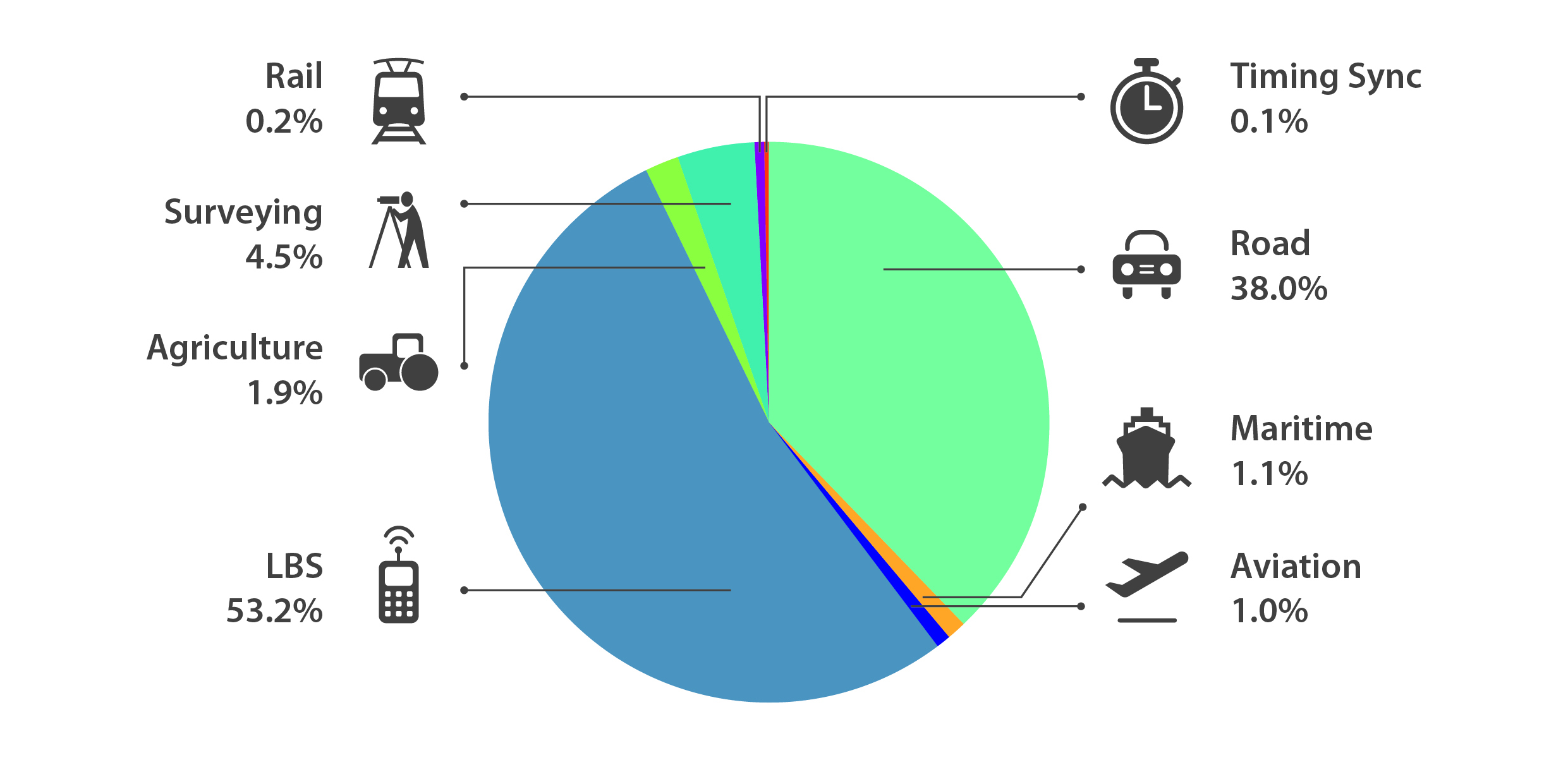
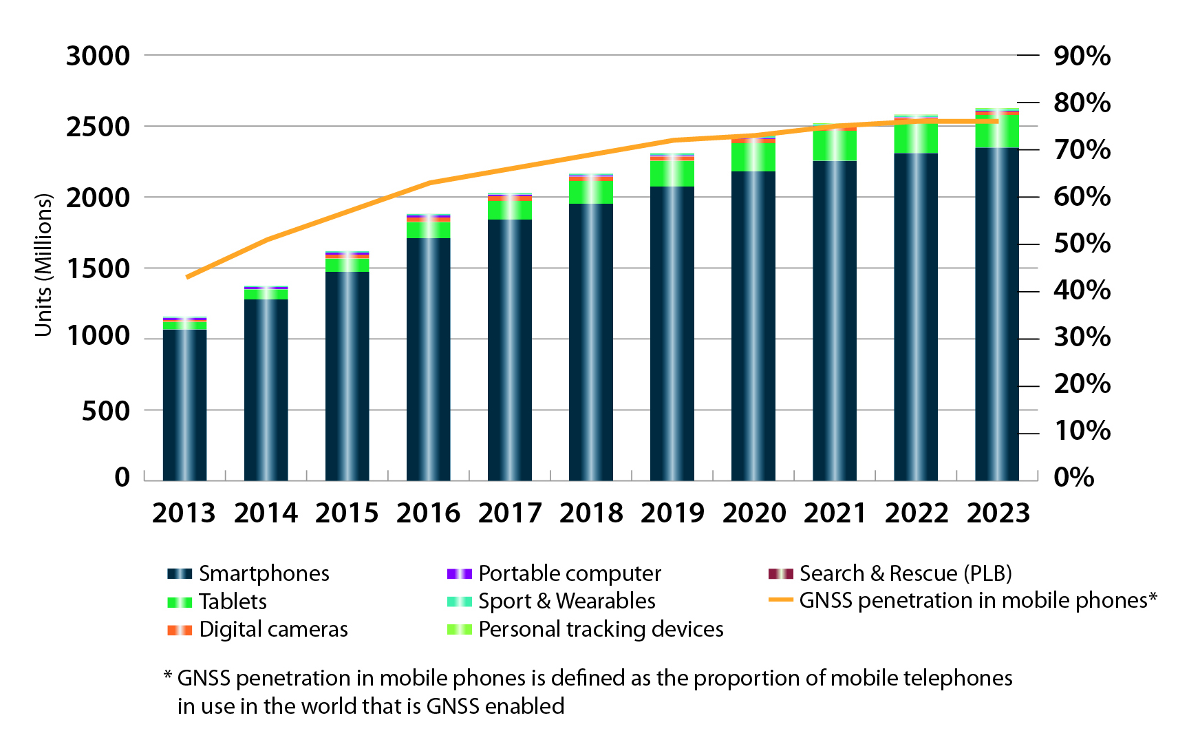
Location-Based Services (LBS) and Road dominate cumulative GNSS revenues, driven by booming sales of smartphones and in-vehicle devices, location-aware applications and data services.
With emerging economies catching up in terms of GNSS devices per capita, the Digital Divide will narrow, driven by the take-up of smartphones. The growing dominance of smartphones (3.08 billion in 2014) is foreseen as the most popular platform to access LBS.
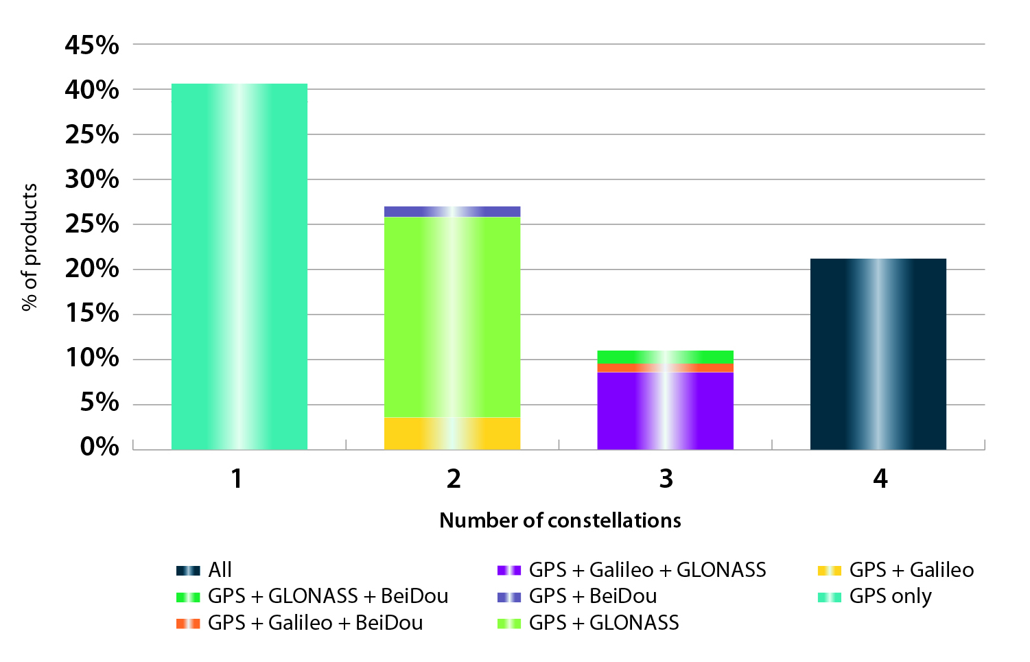
In the analysis of the capabilities of GNSS receivers and chipsets, it is reported that more than 60 percent of currently available receivers and chipsets support a minimum of two constellations with more than 20 percent supporting all four of them.
FIGURE 2. SUPPORTED CONSTELLATION BY RECEIVERS Chart shows the percentage of available receivers capable of tracking signals from one GNSS (such as GPS only), two GNSS (GPS + Galileo, GPS + GLONASS, GPS + BeiDou), three GNSS (GPS + Galileo + GLONASS, GPS + Galileo + BeiDou, GPS + GLONASS + BeiDou) or tracking signals from all constellations at the same time. The percentages add up to 100 percent. We can conclude that almost 60 percent of all available receivers, chipsets and modules are supporting a minimum of two constellations, showing that multi-constellation is becoming a standard feature across all market segments.
New Charts
The report includes new infographics presenting:
Global GNSS downstream market size, core and enabled (2013 to 2023)
GNSS industry share by region (2012)
The global shares of companies among components manufacturers, systems integrators and value-added service providers (2012)
Capability of GNSS receivers and chipsets, all segments (2015)
Supported constellation by receivers and chipsets , all segments (2015)
Detailed analysis of key GNSS segments: LBS, Road, Aviation, Rail, Maritime, Agriculture, Surveying, Timing and Synchronization, quantified in terms of:
Shipments of GNSS devices by application and region (2013 to 2023)
Installed base of GNSS devices by application and region (2013 to 2023)
Core revenues from GNSS device sales by application and region (2013 to 2023)
Capability of GNSS receivers and chipsets (2015)
Supported constellation by receivers and chipsets (2015).
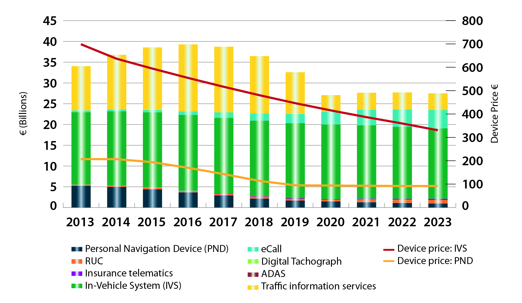
FIGURE 3. LOCATION-BASED SERVICES SECTOR GNSS shipments by type; GNSS penetration in mobile phones is defined as the proportion of mobile telephones in use in the world that is GNSS enabled.FIGURE 4. ROAD SECTOR Core revenue from GNSS device sales and services by application.
Methodology
The “GSA GNSS Market Report” is compiled by the GSA and the European Commission and was produced using the GSA’s systematic Marketing Monitoring and Forecasting Process.
The underlying market model uses advanced forecasting techniques applied to a wide range of input data, assumptions, and scenarios to forecast the size of the GNSS market in terms of shipments, revenue and installed base of receivers.
Historical values are anchored to actual data in order to ensure a high level of accuracy. Assumptions are provided by expert opinions and model results are cross-checked against the most recent market research reports from independent sources, before being validated through an iterative consultation process with sector experts and stakeholders.
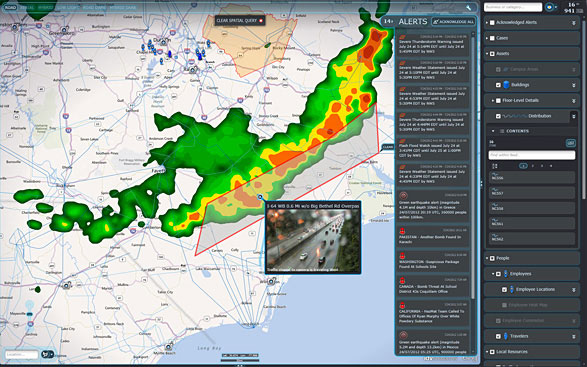
IDV Solutions’ Visual Command Center is a physical security and risk visualization (PSRV) software that unites data from external sources, enterprise systems and internal devices into a real-time, common operating picture of risk and security.
IDV Solutions, a corporation that specializes in business intelligence, physical security and risk visualization software, has formed a technical partnership with Geofeedia, producer of a cloud-based social media monitoring platform. Through the partnership, Geofeedia’s location-based social media monitoring data will now be integrated into IDV Solutions’ Visual Command Center Enterprise Risk Visualization (ERV) software.
The companies say the combination of the two technologies enables security, supply chain and business continuity teams to gain instant intelligence from multiple social media networks for a myriad of risk events — from a political demonstration to a natural disaster. The location-based visualization filters out excess noise to show important social media posts in the context of locations of interest, such as facilities, employee locations, supply routes or traveling executives.
“Companies are looking for ways to efficiently gain actionable intelligence from social media,” said Ian Clemens, chief technology officer and co-founder of IDV Solutions. “The immediacy of social media combined with the alerting and locational context offered by Visual Command Center enables organizations to make more effective use of social media to protect employees, facilities and business continuity.”
The Visual Command Center provides a real-time, common operating picture of assets, personnel and operations in relation to potential threats to those assets. It unites information on global sources of risk — such as weather, terrorism and natural disasters — with data from internal data stores and physical security systems on an interactive map and timeline. When a risk is detected near an asset or employee location, the Visual Command Center automatically generates an alert and provides tools to assess whether the risk is a threat and take immediate action to mitigate the impact of the threat.
The Geofeedia integration complements the Visual Command Center’s Twitter Visualization and Alerting Module by providing information from more social media networks and visualizing all posts within a selected area.
Geofeedia enables organizations to filter and analyze social media content by location in real time across multiple sources. Users search for a city, address or location name, draw a virtual perimeter around the specific area of interest,and access geo-tagged social media content from within those boundaries.
“Location resolves the challenge of monitoring the massive amounts of cluttered data to identify meaningful, real-time on-the-ground intelligence when and where it matters most,” said Phil Harris, CEO and co-founder of Geofeedia. “We are thrilled to be able to help more organizations take advantage of our real-time, geotagged social media data to prevent, protect and respond to valuable intelligence.”
This year’s Mobile World Congress in Barcelona was the biggest ever, with 95,000 attendees and thousands of booths, conferences and people with sore feet walking a cavernous exhibition hall. While the Geneva Auto Show ran close to the same dates, connected vehicle companies and technology were prominently featured. What was interesting, however, was the rise of indoor positioning companies and mobile advertising agencies with interest in location.
BARCELONA — Joining the 95,000 or so Mobile World Congress attendees were about three dozen companies who are offering indoor location and location advertising services. These companies have exhibited at previous conferences, but not in the numbers this year.
At the huge Fira convention center where MWC was held March 2-5, Los Altos, Calif.-based Pole Star installed more than 600 beacons for indoor location. Visitors were able to be guided to booths and other areas through an interactive map. “Business was good in 2014, we sold 10,000 beacons. We are making money,” said Christian Carle, Pole Star CEO.
One analyst said that the big change at MWC wasn’t the number of indoor positioning companies and demos, but the maturity and breadth of the technology. “Intel announced indoor positioning capabilities in their Wi-Fi chip, and had a demo that was very impressive. Many smaller companies that in past years were showing raw technology were showing polished solutions this year, such as Quuppa, MTI and Sensewhere, said Bruce Krulwich, Grizzly Analytics president, who has authored a report identifying 150 indoor positioning companies. “I definitely see a shake-out coming up, but it won’t be one technology prevailing over another. Different technologies meet different needs in the industry, and different technologies fit different sites. There are technologies that deliver universal indoor positioning, without any infrastructure or preparation, such as Wi-Fi multilateration and sensor fusion.”
Krulwich said that there is a shake-out that’s already started because there are too many companies working on similar technologies. “Start-ups in the area that don’t have differentiating innovation, don’t have integration into retail or other back-end systems, and don’t have market penetration, are already finding themselves in a challenge. But companies with clear innovations and commercial deployments will do fine,” he said.
United Kingdom-based Sensewhere is using crowdsourcing in its indoor positioning software. The software uses radios to scan for Wi-Fi and Bluetooth to allow an IP location to reference the sources and form a location database.
“It’s what we call the universal indoor positioning versus venue specific indoor positioning, which can work anywhere — we just need a crowd of people. Our target partners are handset manufacturers, network operators, social media, social network providers, and also chipset guys as well,” said Rob Palfreyman, Sensewhere CEO. “So, there are obviously a lot of companies like Google looking at venues; there is Micello and TomTom looking at add-ins in the indoor location, which is great news, but it just needs to have a technology that can drive the blue dot on their map, and we feel that Sensewhere is the right place to provide that blue dot because of the crowdsourcing global nature of our approach.”
One company, which has developed a popular mobile game, is using its network to attract advertisers for its location-based ad platform. “We already have the infrastructure in place because of our mobile game. With our platform, we can allow advertisers to launch campaigns using our beacon signals and geofencing,” said Pedro Jahara, CEO of Brazil-based RevMob.
New location technology like the ability to track SIM cards was rolled out at MWC. W-Locate, which is partnering with Morpho in Thailand, is tracking SIM cards with its XimLoc product, which the company said is more accurate indoors than other technology.
Even such companies as Geotab, which is a strong player in the fleet market, are leveraging MWC to continue a foothold in the European market. The company displayed its IOX-CAN system that can send data from a mobile device to the MyGeotab system, which can be viewed an analyzed by fleet managers, said Maria Sotra, Geotab marketing manager.
Geotab also partnered with Telefonica in November 2014 to focus efforts in Spain, Germany and the United Kingdom, Sotra said.
At MWC, location-based advertising market is gaining traction as advertisers are seeing the benefit of locating and attracting customers. New York-based xAd said it has doubled its revenue for the second year. “We have billions of mobile ads processed and billions of ad impressions. The company is profitable,” said Dipanshu Sharma, xAd founder and CEO.
He said the company has expanded into France and Germany and added China to its global ad network.
Another company that is using location technology as a differentiator is Airpush, which had another big presence at MWC. The company’s Abstract Banners was a big draw to attendees. Location, particularly geofenced areas, have created a call to action for consumers, which is attractive to advertisers, said Cameron Peeples, Airpush vice president of marketing.
Connected Car Still Big Opportunity at MWC
Although the Geneva Auto Show was starting as the MWC was ending, there were still several big announcements by connected car companies in Barcelona. Even the well-publicized Samsung S6 and S6 Edge and HTC One M9 handset rollouts included Mirrorlink, the connected vehicle standard from the Connected Car Consortium.
In another big announcement, Audi and AT&T said that all 2016 model vehicles equipped with Audi connect will come with the carrier’s 4G LTE or 3G coverage. This increase in services is big because the auto giant just rolled out 4G AT&T service in Audi A3s last year.
AT&T selected Airbiquity to provide end-user registration and device management connected vehicle services for select customer programs. “Airbiquity will deliver these services to AT&T using our Choreo cloud-based connected vehicle services delivery platform and project management, engineering, and operations teams,” said David Jumpa, Airbiquity chief revenue officer. “This is a ‘white label’ agreement whereby AT&T will integrate Airbiquity’s service delivery capability into AT&T’s connected vehicle customer solutions.”
Another location company is making huge inroads in connected vehicle markets with its Glympse for Autos product. Glympse will be installed in select Volkswagen and Peugeot models through MirrorLink, said Bryan Trussel, company co-founder and CEO.
The app allows users to share location from their vehicle by setting the recipient and timer, and hitting send. The company has a similar app for Gogo inflight aviation networks to allow a person on the ground to know where an airplane is for picking up passengers.
In other connected car news, Accenture is providing Fiat Chrysler Automobiles the capability of in-car, Internet-based services. Starting with the new Fiat 500X, Uconnect Live services, which was co-developed by Accenture, will power an infotainment system that offers music and news services, social network access, the ability to monitor driving style and a range of diagnostic services.
Accenture also partnered with Visa for an IoT-based connected car commerce test. At MWC, the company tested a scenario where drivers could order food from the car using cellular, Bluetooth and beacon connectivity. Accenture deployed a similar system with BMW’s ConnectedDrive, which allows customers to choose services in real time for a vehicle.
Health Market Even Has Location Potential
Niche location applications are growing as Internet of Things, or IoT, markets start to grow. One company taking advantage of the mobile market is Annapolis, Md.-based TCS, which featured its VirtuMedix platform in its MWC booth.
The platform is tailored to emergency physicians as part of the growing market for video telemedicine products and mobile health, said Jay Whitehurst, TCS commercial software group president. “It’s already saving lives,” he said of the platform, which combines encryption, navigation, mapping and messaging.
While the product, now being rolled out in a North Carolina emergency medicine group, provides patients with an alternative to urgent care centers and emergency rooms, it also can be used for longer term cases such as assisted living and rehab centers, the company said.
Whitehurst said TCS has made several company acquisitions that have played a part in new product rollouts, which include the company’s Trusted Location. The application allows financial firms, online gaming companies and others to identify and prevent credit-card fraud. The application identifies and validates a device’s location worldwide.
In other Mobile World Congress news:
Spirent said its simulators have the capability to evaluate Wi-Fi Offload and Wi-Fi performance of mobile devices on its test framework. The new product allows companies to test multiple devices on a single unit to cover Wi-Fi/LTE mobility and interoperability. The testing is important in light of wireless carriers’ strategy to extend VoLTE in areas where cell coverage is limited, said Saul Einbinder, Spirent vice president, venture development.
Google Waze said its Google Mobile Service (GMS) will be available as a preinstall option on mobile devices. OEMs and carriers can preinstall the app on their handsets so consumers can use the service immediately, the company said.
Trimble’s ALK said its ALK Maps and route visualization software is now available in Europe. ALK Maps, launched in the United States in 2012, allows users to overlay routing, geocoding points, weather and other features, the company said.
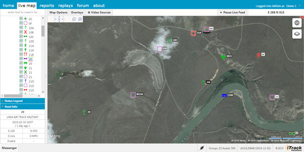
Integrated Tracking (iTrack) Solutions Loki Gen 6 is a web-based mapping software derived from a series of other Loki software products focused on asset tracking for large fleets of vehicles.
The maps are provided by Bing, but custom mapping can also be used with the support of Esri ArcGIS REST services and shapefiles.
iTrack Solutions is based in Calgary, Canada, and provides GPS tracking, mobile data communications and display software. The Loki Gen 6 features are listed below.
Home Home is a configurable dashboard showing plans, schedules, calendars and other details.
Live View Live View shows the live BING map from anywhere in the world, which includes maps, satellite and aerial imagery as well as maps provided by the user. Video streams are supported, and a 3D viewing feature is provided from Cesium. A user can add or draw features on the map to share with other users.
Photo: Integrated Tracking Solutions
Communication With this feature, users can communicate one-to-one or through a chat room, which includes video chat functionality.
Management An administrative user can assign tracking devices to vehicles, assign vehicles to subgroups, assign subgroups to larger groups or drivers to vehicles. An administrator also can set privileges for individual users.
Access to data Users can generate and view a replay on the fly as well as generate reports for vehicle tracking, hours in service, mileage, stop location and speed.
Observations, Analysis The forum feature provides a place group discussion, which becomes part of the Loki database, is searchable and can be linked to reports and replays.
IDV Solutions’ Visual Command Center is a physical security and risk visualization (PSRV) software that unites data from external sources, enterprise systems and internal devices into a real-time, common operating picture of risk and security. Photo: IDV Solutions
IDV Solutions, a corporation that specializes in business intelligence, physical security and risk visualization software, has formed a technical partnership with Geofeedia, producer of a cloud-based social media monitoring platform. Through the partnership, Geofeedia’s location-based social media monitoring data will now be integrated into IDV Solutions’ Visual Command Center Enterprise Risk Visualization (ERV) software.
The companies say the combination of the two technologies enables security, supply chain and business continuity teams to gain instant intelligence from multiple social media networks for a myriad of risk events — from a political demonstration to a natural disaster. The location-based visualization filters out excess noise to show important social media posts in the context of locations of interest, such as facilities, employee locations, supply routes or traveling executives.
“Companies are looking for ways to efficiently gain actionable intelligence from social media,” said Ian Clemens, chief technology officer and co-founder of IDV Solutions. “The immediacy of social media combined with the alerting and locational context offered by Visual Command Center enables organizations to make more effective use of social media to protect employees, facilities and business continuity.”
The Visual Command Center provides a real-time, common operating picture of assets, personnel and operations in relation to potential threats to those assets. It unites information on global sources of risk — such as weather, terrorism and natural disasters — with data from internal data stores and physical security systems on an interactive map and timeline. When a risk is detected near an asset or employee location, the Visual Command Center automatically generates an alert and provides tools to assess whether the risk is a threat and take immediate action to mitigate the impact of the threat.
The Geofeedia integration complements the Visual Command Center’s Twitter Visualization and Alerting Module by providing information from more social media networks and visualizing all posts within a selected area.
Geofeedia enables organizations to filter and analyze social media content by location in real time across multiple sources. Users search for a city, address or location name, draw a virtual perimeter around the specific area of interest,and access geo-tagged social media content from within those boundaries.
“Location resolves the challenge of monitoring the massive amounts of cluttered data to identify meaningful, real-time on-the-ground intelligence when and where it matters most,” said Phil Harris, CEO and co-founder of Geofeedia. “We are thrilled to be able to help more organizations take advantage of our real-time, geotagged social media data to prevent, protect and respond to valuable intelligence.”
Ride service Uber is buying mapping and search startup deCarta, reports Mashable, which said it learned of the deal from an Uber representative.
The deal was expected to close earlier this month. Uber plans to use deCarta’s technology and talent to fine-tune its products and services that rely on maps, including UberPOOL, the smartphone-based ride-sharing app.
Thirty out of 40 deCarta employees will remain with the company, including Kim Fennell, chief executive officer and president, Mashable said. deCarta will continue to operate as a wholly-owned subsidiary of Uber, but will use its own name.
Founded in 1996, deCarta is privately held, and headquartered in San Jose, Calif., with international offices and distributors in Germany, China, Brazil and South Africa. deCarta is a global location-based services (LBS) technology company that provides specialized geospatial technologies for online mapping, routing, navigation, geocoding, local search and geo-data integration and processing. The company’s platform is used by high-volume LBS applications and services in the mobile, Internet, enterprise-fleet and automotive markets. Customers and technology partners include Samsung, Inrix, T-Mobile, FullPower MotionX GPS Drive, Appello, Denso, Ford, GM OnStar, Masternaut, Wireless Matrix, eMapgo, Nokia/HERE, Spot-On-Time, Telstra/Sensis, TomTom, WHERE/eBay.
In February, Uber announced a partnership with Starwood Hotel and Resorts where Starwood Preferred Guest members earn points towards free hotel stays for every dollar spent riding Uber.
Esri and RouteSmart Technologies, Inc., are collaborating to help postal organizations deliver packages reliably, efficiently, and accurately. The companies provide comprehensive dynamic routing solutions based on Esri’s ArcGIS platform.
National postal and global and regional parcel delivery services, including Whistl, Posti, and Swiss Post, are among the customers that leverage these routing solutions. Most customers have experienced cost savings of 15 percent, on average, through reduced working hours, mileage, and new vehicle acquisition. Customers also report growth opportunities through opening new lines of distribution business to support the burgeoning e-commerce delivery segment.
“By integrating location-based analysis with a postal organization’s traditional business systems, such as sorting machines and address management systems, we are solving territory planning and route management challenges these organizations are facing,” said Chris Walz, vice president of sales and marketing for RouteSmart Technologies. “With our help, they can align to the new realities of postal and parcel distribution economics brought on through the growth of e-commerce shipping volumes and declining letter volumes.”
Esri and RouteSmart will share how they are helping postal organizations continue to be drivers of innovation in transportation and operational efficiencies at the European Post and Parcel Services Conference in Vienna, Austria, March 24–26.
“One of the biggest upcoming challenges for the postal industry will be the adoption of fully automated vehicles for deliveries,” Hall said. “With our partner RouteSmart, we provide a path for migration with the help of advanced location intelligence, optimization, and analysis tools.”
In the report, the analysts have identified and deciphered the market dynamics in important GNSS industry segments, highlighting the areas offering promising possibilities for companies to boost their growth, according to Research and Markets. The report studies the market by sectors including location-based services (LBS), transportation (further divided into road navigation, rail navigation, air navigation and marine navigation), surveying and agriculture. The GNSS application market is further studied by region: North America, Europe, Asia-Pacific, and Rest of World.
The report provides a complete overview of the GNSS market globally. All the current trends and drivers, coupled with potential growth areas of the GNSS industry, have been evaluated in the report. Furthermore, the report provides information on opportunities in the industry for different companies in the chapter titled Opportunity Assessment.
Additionally, to provide an exhaustive knowledge of the prospects for GNSS players on the geographical front, the report provides comprehensive knowledge of the 10 most worthwhile GNSS markets around the world (U.S., Canada, UK, France, Germany, Russia, Japan, China, South Korea and India). It includes information about the present state and future outlook of the LBS and telematics markets in these countries along with information about their personal navigation systems such as GPS, BeiDou,Galileo, GLONASS, QZSS and IRNSS.
The report also looks into the competitive landscape covering business overviews, key financials, product analyses, recent developments and strengths and weaknesses of each of the players.
Key trends considered in the report include:
Driverless Car: New GNSS Technology Use
Indoor GNSS Positioning Poised for Growth
People, Pets and Thing Finder: The Next Attraction
GNSS Based Products: A Burgeoning Market Opportunity
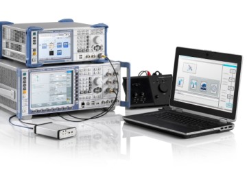
Rohde & Schwarz adds ERA GLONASS to its reliable test solution for in vehicle emergency call systems. Photo: Rohde & Schwarz
Effective January 1, 2015, all new car models introduced to the Russian market must be equipped with the automatic ERA-GLONASS emergency call system. Rohde & Schwarz now offers a standard compliant test solution for manufacturers and suppliers of these in-vehicle systems.
Rohde & Schwarz is demonstrating its ERA-GLONASS test setup at Mobile World Congress, being held this week in Barcelona, Spain.
The test setup consists of the R&S CMW500 wideband radio communication tester and R&S SMBV100A vector signal generator as a GNSS simulator. This setup allows manufacturers and suppliers of automatic in-vehicle systems (IVS) to perform reliable and reproducible pre-conformance tests on their ERA-GLONASS modules in the lab.
In the Russian Federation, ERA-GLONASS works much like the European Union’s eCall system. When an accident occurs, the IVS connects with a public safety answering point (PSAP) via the local wireless communications network and transmits a standardized minimum set of data (MSD). In addition to GLONASS or GPS coordinates, the MSD also contains data with information about the accident vehicle as specified in ERA-GLONASS. If no voice connection can be made or if data cannot be transferred via the voice channel, the MSD is sent to the PSAP via SMS. This fallback option is a special ERA-GLONASS feature. The Russian system is also certified for 2G and WCDMA networks.
Rohde & Schwarz developed its R&S CMW-KA095 application software to meet ERA-GLONASS requirements in line with Russia’s GOST specification. Based on the R&S CMW-KA094 eCall software, the R&S CMW-KA095 simulates a PSAP and controls the R&S CMW500 emulating a wireless communications network in the lab. The software also controls the GNSS simulator that supplies the coordinates required for vehicle localization. With this solution, users can verify whether their IVS modem is able to successfully initiate an emergency call, transmit the correct MSD and establish a voice connection with a PSAP. The results are interpreted in line with the GOST specification.
The ERA-GLONASS SMS protocol has also been integrated into the test solution, making it possible to test the SMS functionality of the IVS modem when no voice connection is available.
The test solution is fully automated because of the R&S CMWrun sequencer software. The R&S CMW-KT110 eCall/ERA-GLONASS test package provides a user-friendly, automated functional test in line with GOST55330, enabling users to verify the operability of an entire system in the lab and document it in a report.
InvenSense Inc. is making available its InvenSense Positioning Library (IPL) software, designed to provide sensor-assisted positioning in places where GNSS alone cannot provide desired accuracy. Invensense is a provider of intelligent sensor system on chip for motion and sound in consumer electronic devices.
InvenSense made the announcement at Mobile World Congress, taking place in Barcelona, Spain March 2-5.
The IPL incorporates advancements in sensor-assisted positioning algorithms that allow use of inertial sensors to improve GNSS positioning in urban areas where satellite signals are either blocked or distorted by multipath, enabling continuous location availability while driving in underground parking lots, tunnels, or walking in urban canyons. The IPL enables continuous and accurate position, velocity and orientation in challenging operating environments.
These sensor-assisted positioning algorithms have been designed to operate under normal pedestrian and driving use without restrictions on the device orientation. Supported pedestrian use includes handheld, hand swinging, in pocket, call mode and belt holster. The algorithms also allow any use within the vehicle, such as in cradle, cup holder or simply left on a seat. The software was designed in a way to maximize accuracy and minimize constraints on the user.
The IPL is designed to operate with an IMU and GNSS receiver as minimum hardware. Integration with a magnetometer, barometer, and vehicle speed sensor is also available, which provides additional heading integrity as well as height and velocity accuracy for sensor-assisted positioning.
IPL is designed for smartphones using Android, iOS, Windows and general Linux operating systems and has already started shipping commercially. The underlying navigation technology comes from years of development at Trusted Positioning Inc., which was acquired by InvenSense this past summer.
“With more consumers using their smartphones for turn-by-turn navigation on foot or in vehicle, one of the most frustrating user experience issues is losing your GPS (GNSS) signal in an unfamiliar location or being re-routed erroneously due to multipath errors,” said Ali Foughi, vice president of Marketing and Business Development at InvenSense. “With IPL technology, high-accuracy location guidance is always available and provides smartphone OEMs with a differentiated user experience and consumers with a more reliable navigation solution.”
The InvenSense Positioning Library is available immediately.
InvenSense is exhibiting in booth #D61 in Hall 7 at Mobile World Congress.