Enter GPS III. The long-awaited navigation payload for the next-generation satellite pulled into its new temporary home over the September 13 weekend, the Lockheed Martin Space Systems facility in Littleton, Colorado. Lockheed is the U.S. Air Force’s prime contractor for the first batch of eight GPS III satellites.
Exelis Geospatial Systems has committed to delivering the payloads for the second, third, and fourth GPS III satellites “right on the heels” of the first, according to Gen. John Hyten, commander of Air Force Space Command. “If that’s the case, in the not-too-distant future GPS III will be in good shape,” he added. The first GPS III launch is now scheduled for 2016.
Exelis has built GPS payloads since the beginning of the program, but found new challenges over the last two years posed by advanced features of the modernized version. “First-time development and integration issues, including design changes to eliminate signal crosstalk” have set back the schedule.
According to reports, Lockheed Martin has a group of initial platforms readied on its production line to take the incoming payloads.
Still ahead, completion of acceptance testing following integration with the first satellite platform.
Earlier this year, Lockheed Martin issued a request for information on alternate payload providers, and received responses from five companies. In June, the Air Force issued a call for contractors interested in building the next batch of GPS IIIs. Northrop Grumman and Boeing have responded.
The U.S. Air Force’s fleet of GPS Block IIR and IIR-M satellites, manufactured by Lockheed Martin, have reached 200 collective years of operational life. The 20 satellites make up about two thirds of the current GPS constellation.
Originally launched between 1997 and 2009 to add capabilities to the GPS constellation and to replace other aging satellites, the 12 GPS IIR and eight IIR-M satellites have maintained an availability record of 99.96 percent, which represents only 10 minutes of down time per satellite during all their years of operation.
The 200-year milestone will be celebrated with a brief cake-cutting “ceremony” during ION GNSS, on Wednesday at 12:30 p.m., at the Lockheed Martin booth.
“This is a tremendous GPS operations and sustainment performance milestone, and we applaud the men and women of the Second Space Operations Squadron of the Air Force’s 50th Space Wing, as well as the industry team who support them,” said Mark Stewart, vice president for Lockheed Martin’s Navigation Systems mission area. “The world relies on GPS every day for things like synchronizing global banking and investing, shipping and transportation, search and rescue operations, ATM transactions and even precision farming.”
This spring, the IIR-M satellites played a major role in the continued modernization of the GPS constellation. To help manufacturers develop and test next-generation advanced civil GPS receivers, under the direction of Air Force Space Command and in collaboration with the Department of Transportation, these satellites began early broadcasting of test civilian navigation, or CNAV, messages on a new signal planned for all future satellites.
Making these milestones even more significant is the fact that the GPS IIR and IIR-M satellites were designed to last 7.5 years, or collectively about 150 years. All 12 IIR satellites are currently operating beyond their design life with the oldest operating for more than 16.5 years. Three of eight GPS IIR-M satellites have surpassed their expected life span and all satellites will have done so in 2017.
To meet evolving GPS user demands, Lockheed Martin is developing the next-generation GPS III satellites. These satellites will deliver three times better accuracy, provide up to eight times improved anti-jamming capabilities, and include enhancements which extend spacecraft life to 15 years, 25 percent longer than the newest Block IIF satellites. GPS III will be the first generation of GPS satellite with a new L1C civil signal designed to make it interoperable with other international GNSS.
DigitalGlobe, a provider of commercial high-resolution Earth observation and advanced geospatial solutions, successfully launched WorldView-3, the company’s sixth and most advanced super-spectral, high-resolution commercial satellite.
The satellite launched August 13 on a Lockheed Martin Atlas V rocket from Vandenberg Air Force Base in California.
“The successful launch of WorldView-3 extends DigitalGlobe’s commanding technological lead and will enable us to help our customers see through smoke, peer beneath the ocean’s surface, and determine the mineral and moisture content of the Earth below — all with unprecedented clarity,” said Jeffrey R. Tarr, chief executive officer of DigitalGlobe.
WorldView-3 will collect super-spectral imagery at 0.31 meter resolution — delivering five times the clarity of the company’s nearest competitor. In addition, WorldView-3 will offer the most spectral diversity available commercially, the company said, and will offer multiple shortwave infrared (SWIR) bands that allow for accurate imaging through haze, fog, dust, smoke and other air-born particulates. The satellite will also offer CAVIS — a cloud, aerosol, water vapor, ice and snow atmospheric correction instrument — which monitors the atmosphere and corrects data for an unprecedented level of consistency.
“The unmatched abilities that WorldView-3 brings to our constellation will enable us to provide our customers with information and insight never before possible and advance our efforts to create a living digital inventory of the Earth,” Tarr said.
The satellite and atmospheric monitoring instrument called CAVIS were built by Ball Aerospace. Exelis built the integrated, super-spectral payload consisting of a telescope, sensor and shortwave infrared system, making WorldView-3 the first commercial satellite to carry such capabilities. A United Launch Alliance Atlas V launch vehicle provided by Lockheed Martin Commercial Launch Services (LMCLS) delivered the satellite into orbit.
First, Lockheed Martin began investigating options for its GPS III payload supply line last year. Then in June of this year, the U.S. Air Force opened a “sources sought” initiative for a production-ready GPS space vehicle, equipped with an alternate payload, for consideration alongside the Lockheed Martin-built GPS III vehicle. Grumman and Boeing have responded to the U.S. Air Force call. Now the U.S. Senate has jumped into the act, with a 2015 defense spending bill that directs the Air Force to allocate at least $20 million for work on a space-based “digital navigation instrument” as a possible alternative to the payload developed for the GPS III satellites.
The Senate Appropriations defense subcommittee stated that it “believes that early Air Force investment, when combined with industry investment, into the development of a digital navigation payload will significantly reduce cost and schedule risk for the future GPS constellation.” What exactly is meant by a “digital navigation payload” — as opposed to the current payload under construction — is unclear. The systems on earlier GPS satellites probably used some analog components. Even modern receivers have an analog front end before the analog-to-digital converter. Perhaps the Senate Appropriations subcommittee wants more digitization in the nav unit.
Disaggregation. Further, the committee “firmly believes that movement away from large satellites, where possible, will result in significant cost savings and reduce the schedule to deliver payloads into orbit.”
This idea calls for dispersing space capabilities away from large platforms and into smaller ones.It would require, at the very least, a new constellation architecture for GPS III, an as-yet unexplored concept.
Status. Lockheed Martin is under contract to deliver the first eight GPS III satellites, but the award for up to 22 further IIIs remains open. Difficulties with the payload for the first batch of satellites mean that although Lockheed has three space vehicles ready, it has no signal payload to put aboard them. Subcontractor Exelis is at work on that.
Lockheed Martin spokesperson Chip Eschenfelder has stated that “signal cross talk issues are resolved. The SV01 navigation payload forecast delivery to Lockheed Martin is fall 2014. Once the first navigation payload is delivered, we are into the production phase.”
General John E. Hyten
General Support. At June’s ION Joint Navigation Conference, General John E. Hyten, currently vice and soon to be commander of USAF Space Command, while evincing unqalified support for the system operators, did not address the GPS III manufacturing and supply issue. He confined his industry-related remarks to warning commercial PNT vendors and government program managers to cease placing commercial GPS receivers in critical government systems that support warfighters, government users, and critical national infrastructure.
He strongly advocated for Selective Availability Anti-Spoofing Modules and M-Code to help secure these critical systems against interference, jamming and spoofing, and urged manufacturers to build their devices in strict adherence to the U.S. government’s ICD process.
FCC Seeks Spectrum but Supports GPS
In a June 20 workshop on “GPS Protection and Receiver Performance,” the U.S. Federal Communications Commission (FCC) reiterated the need to safeguard critical infrastructure and public safety — two key uses of GPS.
Despite fears that the FCC would call for new GPS receiver standards, the meeting took a protective and conciliatory tone, even as the FCC continues to seek more frequencies for mobile broadband, citing the need “get more out of the radio spectrum.”
FCC Chairman Tom Wheeler stated, “Today is not about FCC-mandated receiver standards. Rather it is about the best way to protect GPS operations in the context of evolving technology and adjacent spectrum activities.”
The specter of adjacent spectrum use hovered through the day, fully appearing in LightSquared and administration presentations. Otherwise, scant mention was made of the 2012 notion that GPS receivers should be modified to stop alleged “peeking” into adjacent spectrum.
Panel discussions focused on GPS in critical infrastructure and public safety, with presentations by Qualcomm, Motorola, and AT&T. Speakers from T-Mobile, Spirent, Garmin, NovAtel, and John Deere covered GPS’s role in timing and the power grid, financial markets, telecommunication network, and precision agriculture. Paul Galyean of Deere said that “Certainty on the spectrum environment is needed. It’s difficult to design for the future without it.” If GPS receivers had to filter out cellular activity, this “might impact sensitivity, involve excessive size or cost, and might cause distortion of GPS measurements.”
Chris Hegarty, MITRE Corporation, gave a compelling argument for not overhauling receiver methodology: the extremely long lead times for commercial passenger aircraft. “Until 2022 every new Boeing and Airbus is going to fly off with $250,000 worth of navigation equipment that has three $50,000 GPS receivers and antennas and everything else, and they are going to want to use that for 20 to 25 years. So, you have a timing issue. Even if we all decided today that we wanted to do that, some communities simply aren’t going to be able to get it into place until we’re all dead.”
Power Loss Strikes Galileo Satellite
In-Orbit Validation Vehicle May Be Lost to Further Use
The disappearance of signals from Galileo GSAT0104, the fourth in-orbit (IOV) Galileo satellite, arose from a sudden, unexpected loss of power aboard the space vehicle. The exact cause is unknown, or at least unreported as of press time. Some have speculated that the cause could lie in a failure of components around the solid-state power amplifier, including the output multiplexer, cables, or antenna.
If such proves to be the case, ground operators may be powerless to repair the problem. The satellite would be a total loss.
The power outage flashed on May 27, shutting down the satellite’s E1 signal. The signal “re-established itself almost immediately. But as soon as it was back in service, the two other channels’ power dropped and did not recover. The full satellite then was shut down by ground teams,” reported correspondent Peter de Selding.
Looking for a Fix. European Space Agency (ESA) officials stated on July 3 that they would power-on the satellite again during the week of July 7–11 to continue an investigation into the problem, but there have been no subsequent reports. Investigation has been ongoing since the shutdown but has not identified a cause; officials state they have established that it is not related to the onboard atomic clocks.
The four IOV satellites currently aloft differ in both technology and manufacturer from the next phase of Galileo satellites to be launched. The GSAT0104 satellite now in silent orbit was built by Astrium. The newer, operational satellites are produced by OHB-System, following a different payload design. Two of the newer generation are at the Guyana spaceport awaiting a possible late August lift date.
Reporting History. The possibility of a satellite failure was first floated in the June 30 EAGER newsletter (European GNSS and Earth Observation Report), by contributing editor Tim Reynolds. He wrote:
“Has anyone heard anything from Galileo GSAT0104 recently? According to the European GNSS Service Centre, the fourth IOV satellite is ‘unavailable until further notice.’ The setting of unavailability may be due to in-orbit validation testing, as the website implies may be the case, but no further official statement has appeared, nor active user notifications (NAGUs) at http://www.gsc-europa.eu/system-status/user-notifications.”
Two days later, GPSWorld.com posted a follow-up story: “According to reports, the root cause of the outage is under investigation. Some unofficial sources have gone so far as to speculate that GSAT0104’s useful transmission life may be over.”
Then, on July 3, correspondent Peter de Selding (who also contributes to EAGER) reported in Space News, after questioning sources at ESA, that the trouble aboard the fourth IOV Galileo satellite arose from a sudden, unexpected loss of power, as stated in the first paragraph of this article.
Largest Fine in FCC History — $35M — for Chinese Jammer
The Federal Communications Commission (FCC) plans to issue the largest fine in its history against C.T.S. Technology Co., Limited, a Chinese electronics manufacturer and online retailer, for allegedly marketing 285 models of signal jamming devices to U.S. consumers for more than two years.
The FCC applied the maximum fine allowed to each jammer model allegedly marketed by C.T.S., resulting in a planned fine of $34,912,500.
“All companies, whether domestic or foreign, are banned from marketing illegal jammers in the U.S.,” said Travis LeBlanc, acting chief of the Enforcement Bureau. “Signal jammers present a direct danger to public safety, potentially blocking the communications of first responders. Operating a jammer is also illegal, and consumers who do so face significant civil and criminal penalties.”
C.T.S. operates a website that markets consumer electronics to individuals in the United States, where it allegedly misled U.S. consumers by falsely claiming that certain signal jammers were approved by the FCC. In fact, the use of such devices by U.S. consumers is illegal under any circumstance. C.T.S. also sold 10 high-powered signal jammers to undercover FCC personnel.
The FCC also is ordering C.T.S. to cease marketing illegal signal jammers to U.S. consumers and provide information to the FCC about any persons and entities in the United Sates that purchased its devices.
Signal jammers are radio frequency transmitters that intentionally block, jam, or interfere with authorized communications, such as cellphone calls, GPS systems, Wi-Fi networks, and first responder communications. It is a violation of federal law to market, sell, import, or use a signal jammer in the United States and its territories, except in very limited circumstances involving federal law enforcement.
The FCC asks people to report the sale or use of an illegal jammer by contacting the FCC Enforcement Bureau through the FCC online complaint portal, or by calling 1-888-CALL-FCC (or 1-888-225-5322). To voluntarily relinquish a signal jammer, e-mail [email protected]. Additional information, including a Consumer Alert and Enforcement Advisory to retailers, is available at www.fcc.gov/jammers.
At least some of the work on GPS III continues along prepared tracks, with the award of a Lockheed Martin contract to General Dynamics for two more satellites’ worth of communications hardware. General Dynamics Advanced Information Systems, a business unit of General Dynamics, was awarded a $25.4 million full-production contract from Lockheed Martin to support the GPS III Network Communications Element (NCE) for space vehicles seven and eight (SV 07-08). This commitment fills out that aspect of the current Lockheed Martin bevy of eight bought by the U.S. Air Force.
Many if not all components of the GPS III constellation beyond the Initial Eight have been called into question recently, with the U.S. Senate, the Air Force, and Lockheed itself keeping open minds about alternatives.
General Dynamics’ NCE components provide the communications functions for the GPS III satellites, including the ground-to-space command and control channel, the space-to-space inter-satellite channel and the command and telemetry communications channels within each satellite. General Dynamics is now under contract with Lockheed Martin for GPS III SV 01-08. Delivery of the NCE components for SV03 and SV04 are scheduled for this summer.
Compared to prior GPS vehicles, the Air Force’s GPS III satellites will deliver three times better accuracy, provide up to eight times more powerful anti-jamming capabilities and include enhancements that extend spacecraft life 25 percent further. GPS III-series satellites also will carry a new civil signal designed to be interoperable with other international global navigation satellite systems, enhancing civilian-user connectivity.
The majority of the work under contract will be performed at the General Dynamics Advanced Information Systems facilities in Scottsdale, Arizona, and Bloomington, Minnesota.
Northrop Grumman and Boeing have responded to a U.S. Air Force call for contractors interested in building a follow-on set of GPS III satellites, according to a report in Space News.
Lockheed Martin is under contract to deliver the first eight GPS III satellites, but the award for up to 22 further IIIs remains open. Difficulties with the payload for the first batch of satellites mean that although the Lockheed has three space vehicles ready, it has no signal payload to put aboard them. Subcontractor Exelis is at work on that. Delivery delays have prompted the Air Force to look about for alternatives.
Lockheed Martin itself began investigating options for its supply line last year.
Air Force “Sources Sought” Call
The U.S. Air Force issued an official “Sources sought” notice in June on a production-ready GPS space vehicle, equipped with an alternate payload, for consideration alongside the Lockheed Martin-built GPS III vehicle. The first phase of the contract would include two firm-fixed price contracts worth $100–$200 million to demonstrate a competitor to GPS III.
Key requirements are that the satellite must offer a payload alternative to that built by Exelis; the satellite must be ready to launch by 2023; and the production line must turn out two to three new satellites per year.
The second phase features a competition between Lockheed Martin and one or more other companies for as many as 22 satellites. A final contract award would be made in 2017 or 2018.
Current GPS III contractor Lockheed Martin reportedly sent an engineering team to help Exelis expedite a resolution of payload holdups, while simultaneously investigating a switch to other suppliers, beginning with the ninth satellite in the GPS 3 series. Lockheed Martin says five companies responded to its solicitation last year.
Air Force Gives Free Hand. Gen. Ellen Pawlikowski, head of the Air Force Space and Missile Systems Center (SMC), told the national Space Symposium in Colorado in June, “Obviously we want a GPS III that does what its supposed to do, delivered on time, and it’s up to Lockheed to manage its subcontractors. My view is if Lockheed is not happy with their subcontractors nav payload, and they believe that they can get a lower risk approach to delivering a nav payload by seeking a secondary source for that, then that’s clearly a decision for them to make.
“They [Lockheed ] know we are disappointed at the delays that we have seen, the technical issues that their subcontractor has had, and probably they are considering whether an alternative source could provide them a better opportunity.“
Lockheed Martin spokesman Chip Eschenfelder issued a statement: “Exelis has made good progress on the first GPS III space vehicle, SV01 navigation payload. All GPS III SV01 navigation payload components have successfully completed unit acceptance and environmental testing, with the exception of one component, the mission data unit.
“To date, significant MDU hardware testing indicates signal cross talk issues are resolved. The SV01 navigation payload forecast delivery to Lockheed Martin is fall 2014.”
Boeing built the platform and major payload components for the GPS IIF satellites and is one of three companies that received contracts in January 2013 to study how to improve the accuracy, coverage, and efficiency of GPS using smaller satellites.
Northrop Grumman Aerospace of Redondo Beach, California, has already delivered deployable antenna sets to Lockheed Martin for the first six GPS III satellites. The division has delivered more than 1,000 antennas for previous generations of GPS spacecraft, Northrop Grumman said.
The U.S. Air Force is shopping for alternative companies to head the GPS III program after its current contractor, Lockheed Martin Space Systems, hit production delays, according to the Denver Post.
There have been technical problems with the first GPS III satellite navigation system, which is supplied by Lockheed Martin subcontractor Exelis, the newspaper reports.
After the current eight-satellite contract is fulfilled, contracts to build the 22 remaining spacecraft are up for bid, according to a notice posted by the Air Force on the Federal Business Opportunities website.
Exelis’ navigation system was producing signal interference that prevented Lockheed from delivering by its target date earlier this year, which is now anticipated for delivery in 2015. The system is undergoing rigorous tests.
The U.S. Army Tank Automotive Research, Development and Engineering Center (TARDEC) and Lockheed Martin successfully demonstrated additional capabilities of the Autonomous Mobility Appliqué System (AMAS) May 29 at the Department of Energy’s Savannah River Site in South Carolina.
They conducted a driverless line-haul convoy with seven military trucks at speeds up to 40 mph.
The AMAS CAD II demonstration built upon capabilities demonstrated at Fort Hood, Texas, in January, when three unmanned military trucks negotiated oncoming traffic, followed rules of the road, recognized pedestrians, and avoided various obstacles at speeds up to 25 mph in an urban environment.
AMAS is a Joint Capability Technology Demonstrator, or JCTD. That means it’s a joint program between the U.S. Army and the U.S. Marine Corps. The AMAS common appliqué kit consists of the bi-wire active safety kit and the autonomy kit. It uses GPS, lidar systems, Automotive radar, and commercially available automotive sensors to make the system affordable. The AMAS JCTD goal is to standardize these kits across both the Army and Marine Corps and give the warfighter the ability to transform ordinary vehicles into optionally manned vehicles.
Colonel Bruce B. McPeak, Director of Materiel Systems, Combined Arms Support Command, climbs into a Heavy Equipment Transporter (HET) for an autonomous ride-along.
TARDEC is working closely with the U.S. Army Training and Doctrine Command (TRADOC), military users, and the acquisition community to advance the development of autonomous appliqué systems for tactical vehicles and make these capabilities available by 2020.
Autonomy-enabled vehicles will reduce accidents while augmenting the warfighter, and increase capabilities by creating greater stand-off distance from danger, which would make supply distribution safer and more efficient, and provide the flexibility to adapt to tomorrow’s ever-changing and evolving threats.
“The driverless vehicle is coming in both commercial and military applications,” said Bernard Theisen, TARDEC’s AMAS Technical Manager. “The Army is at the forefront of this technology.”
Military and industry VIPs drove alongside the convoy in a bus to watch the unmanned convoy demonstration.
General Dynamics is already under contract with Lockheed Martin to produce the NCE for the first four GPS III space vehicles (SV01-SV04), as well as for the procurement of long lead material for the second set of four space vehicles (SV05-SV08). This follow-on contract provides General Dynamics with the funding to complete the NCE for SV05 and SV06.
General Dynamics’ NCE components provide the communications functions for the GPS III satellites, including the ground-to-space command and control channel, the space-to-space inter-satellite channel, and the command and telemetry communications channels within each satellite. NCE components have been delivered for SV01 and SV02. The NCEs for SV03 and SV04 are scheduled for delivery by June 2014.
“We bring more than a half-century of experience in the spacecraft communications and navigation domain to this program,” said Kirstan Rock, vice president and general manager of Intelligence, Surveillance and Reconnaissance at General Dynamics Advanced Information Systems. “We look forward to continuing working with Lockheed Martin to deliver high-quality, reliable and affordable solutions to the Air Force to advance their mission.”
The Air Force’s next-generation GPS III satellites will improve position, navigation and timing services and provide advanced anti-jam capabilities yielding superior system security, accuracy and reliability.
GPS III is a critically important program for the U.S. Air Force, affordably replacing the aging constellation of GPS satellites currently in orbit. Compared to prior GPS vehicles, GPS III satellites will deliver three times better accuracy, provide up to eight times more powerful anti-jamming capabilities and include enhancements that extend spacecraft life 25 percent further. GPS III-series satellites also will carry a new civil signal designed to be interoperable with other international global navigation satellite systems, enhancing civilian user connectivity.
Gen. William Shelton, chief of Air Force Space Command, said the date when prime contractor Lockheed Martin and payload manufacturer Exelis are expected to have the first GPS satellite ready for launch will slip from its original target at the end of this fiscal year, according to National Defense Magazine. Technical difficulties are slowing the development process, he said.
“We’re not happy at all. Is my patience wearing thin? Yes. Has it gotten to the place where I am going to step off the cliff? No,” he said at a breakfast sponsored by the Air Force Association’s Mitchell Institute.
Gen. Shelton said the Air Force is working closely with the contractors.
Shelton said the issue highlights the problem inherent in relying on one contractor for a critical technology, reports Space News. Exelis Geospatial Systems has supplied the payloads for all previous generations of GPS satellites.
“The payload hardware is built and is currently in test,” said Jared B. Adams, director of communications for Exelis geospatial systems, in an email to National Defense Magazine. “Last year, Exelis identified some development issues with the navigation payload for the first GPS III satellite that needed further work. Significant testing with flight-like engineering units and the first GPS III satellite’s flight hardware indicates that the known technical issues have been resolved, and GPS III will meet all mission and quality requirements.”
The payload delay is not expected to push back the first launch of the Lockheed Martin-built GPS III satellites in 2015. Lockheed Martin Space Systems is under contract to build eight GPS III satellites.
The Lockheed Martin team developing the U.S. Air Force’s next generation Global Positioning System (GPS) recently turned on power to the bus and network communications equipment payload of the program’s second satellite designated GPS III Space Vehicle 2 (SV-02).
The successful powering on of GPS III SV-02, on December 19, 2013, at Lockheed Martin’s Denver-area GPS III Processing Facility (GPF), is a major production milestone which demonstrates the satellite’s mechanical integration, validates its interfaces, and leads the way for electrical and integrated hardware-software testing.
“The GPS III SV-02 bus power on is a significant milestone, positioning SV-02 in line with the Air Force’s first GPS III space vehicle, SV-01, in our GPF, where both satellites are progressing through sequential integration and test work stations specifically designed for efficient and affordable satellite production,” explained Mark Stewart, vice president for Lockheed Martin’s Navigation Systems mission area.
On November 11, 2013, the propulsion core module for SV-02 was delivered to the GPF from Lockheed Martin’s Space & Technology Center, in Stennis, Mississippi, where the core was manufactured. The structural backbone of the satellite, the core contains the integrated propulsion subsystem that allows the GPS III to maneuver on orbit immediately after launch, as well as to conduct repositioning maneuvers throughout its mission life.
The GPS III program will affordably replace aging GPS satellites, while improving capability to meet the evolving demands of military, commercial and civilian users, Lockheed Martin said. GPS III satellites will deliver three times better accuracy; provide up to eight times improved anti-jamming capabilities; and include enhancements which extend spacecraft life 25 percent further than the prior GPS block. The GPS III also will carry a new civil signal designed to be interoperable with other international global navigation satellite systems, enhancing civilian user connectivity.
Lockheed Martin is under contract for production of the first six GPS III satellites (SV 01-06), the first four funded under the original contract and the fifth and sixth recent fully funded by an exercised Air Force option on December 13, 2013. Lockheed Martin had previously received advanced procurement funding for long-lead components for the fifth, sixth, seventh and eighth satellites (SV 05-08).
The first GPS III satellite (SV-01) was powered on February 28, 2013. GPS III SV-01’s spacecraft bus and antenna assemblies were delivered to Lockheed Martin’s GPF this summer. SV-01 is now in the integration and test flow leading to delivery “flight-ready” to the Air Force.
The GPS III team is led by theGlobal Positioning Systems Directorateat the U.S. Air Force Space and Missile Systems Center. Lockheed Martin is the GPS III prime contractor with teammates Exelis, General Dynamics, Infinity Systems Engineering, Honeywell, ATK and other subcontractors. Air Force Space Command’s 2nd Space Operations Squadron(2SOPS), based at Schriever Air Force Base, Colo., manages and operates the GPS constellation for both civil and military users.
Artist’s concept of a GPS III satellite in orbit, courtesy of Lockheed Martin.
Air Force Orders GPS III Satellites 05 and 06 from Lockheed Martin
A December 12 contract modification provided Air Force funding to Lockheed Martin to complete the fifth and sixth GPS III space vehicles (SV 05-06). Lockheeed originally received funding to procure long-lead parts for satellites five through eight (SV 05-08) in February 2013.
The $200,700,415 cost-plus-incentive-fee modification (P00276) on an existing contract (FA8807-08-C-0010) for GPS III space vehicles 05 and 06 means that work will be performed at Littleton. Colorado and Clifton, New Jersey, and is expected to be completed by Dec. 14, 2017 for space vehicle 05 and June 14, 2018 for space vehicle 06. The Air Force Space and Missile Systems Center Contracting Directorate, Los Angeles Air Force Base, California, is the contracting activity.
Galileo Achieves First Airborne Tracking
The European Space Agency’s Galileo satellites have achieved their first aerial fix of longitude, latitude, and altitude, enabling the inflight tracking of a test aircraft.
ESA’s four Galileo satellites in orbit have supported months of positioning tests on the ground across Europe since the first fix in March. Now the first aerial tracking using Galileo has taken place, determining the position of an aircraft using only its own independent navigation system.
The milestone took place on a Fairchild Metro-II above Gilze-Rijen Air Force Base in the Netherlands on November 12. It was part of an aerial campaign overseen jointly by ESA and the National Aerospace Laboratory of the Netherlands, NLR, with the support of Eurocontrol, the European Organisation for the Safety of Air Navigation, and LVNL, the Dutch Air Navigation Service Provider.
A pair of Galileo test receivers was used aboard the aircraft, the same kind employed for Galileo testing in the field and in labs across Europe. They were connected to an aeronautical-certified triple-frequency Galileo-ready antenna mounted on top of the aircraft.
Tests were scheduled during periods when all four Galileo satellites were visible in the sky. The receivers fixed the plane’s position, as well as determining key variables such as the position, velocity, and timing accuracy; time to first fix; signal-to-noise ratio; range error; and range–rate error.
Testing covered both Galileo’s publicly available Open Service and the more precise, encrypted Public Regulated Service, whose availability is limited to governmental entities.
Flights covered all major phases: take off, straight and level flight with constant speed, orbit, straight and level flight with alternating speeds, turns with a maximum bank angle of 60 degrees, pull-ups and push-overs, approaches and landings.
The flights also allowed positioning to be carried out during a wide variety of conditions, such as vibrations, speeds up to 456 km/h, accelerations up to 2 ghorizontal and 0.5–1.5 gvertical, and rapid jerks. The maximum altitude reached during the flights was 3,000 meters.
GPS III Prototype Proves Constellation Compatibility
The Lockheed Martin prototype of the next-generation GPS satellite, the GPS III, has proven that it is backwardly compatible with the existing GPS satellite constellation in orbit.
During tests concluded on October 17, Lockheed Martin’s GPS III testbed successfully communicated via cross-links to Air Force simulators of the current GPS constellation in orbit. The current GPS constellation includes GPS IIR, GPS IIR-M, and GPS IIF satellites.
Testing also demonstrated the ability of an Air Force receiver to track navigation signals transmitted by the GPS III Nonflight Satellite Testbed (GNST). The GNST is a full-sized, functional satellite prototype at Cape Canaveral Air Force Station.
“These tests represent the first time when the GNST’s flight-like hardware has communicated with flight-like hardware from the rest of the GPS constellation and with a navigation receiver,” explained Paul Miller, Lockheed Martin’s director for GPS III Development. “This provides early confidence in the GPS III’s design to bring advanced capabilities to our nation, while also being backward-compatible.”
The first flight-ready GPS III satellite is expected to arrive at Cape Canaveral in 2014, for launch by the Air Force in 2015.
GPS III satellites will be the first GPS space vehicles with a new L1C civil signal designed to make it interoperable with other international global navigation satellite systems.
The GNST has helped to identify and resolve development issues prior to integration and test of the first GPS III flight space vehicle (SV 01). It has gone through the development, test, and production process for the GPS III program first, significantly reducing risk for the flight vehicles, improving production predictability, increasing mission assurance, and lowering overall program costs.
The GPS III team is led by the Global Positioning Systems Directorate at the U.S. Air Force Space and Missile Systems Center.
Lockheed Martin is the GPS III prime contractor, with teammates including ITT Exelis, General Dynamics, Infinity Systems Engineering, Honeywell, ATK, and other subcontractors.
Good News for Users and Manufacturers
The U.S. Air Force is directing transmission of continuous CNAV message-populated L2C and L5 signals starting in April 2014. The move is designed to help development of user equipment compatible with the civil signals. Full text of the CNAV memo appears below.
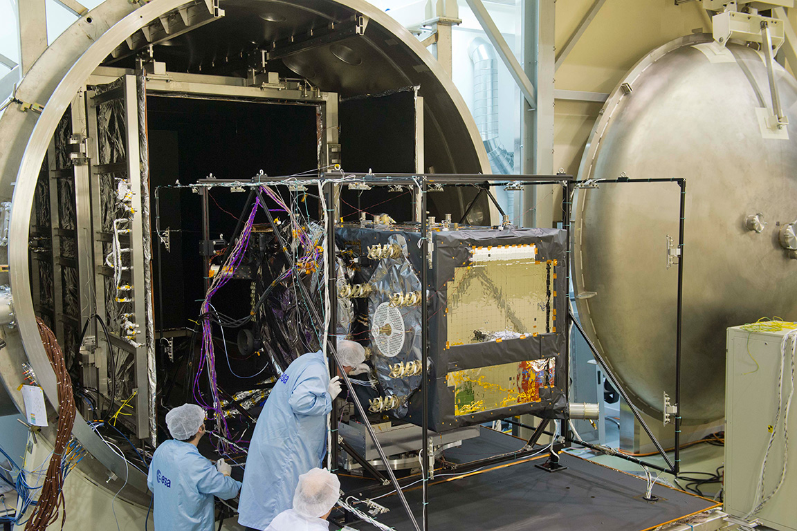
Galileo FOC Satellites Endure Simulated Space Tests
The European Space Agency’s newest Galileo satellite has emerged from five weeks of simulated space conditions. On November 29, a hatch slid open to end its thermal-vacuum test, a milestone on the way to orbit.
The satellite was placed in the 4.5-meter-diameter Phenix chamber in ESA’s ESTEC Test Centre in Noordwijk, the Netherlands, in late October. Once inside, the air was pumped out to create a space-quality vacuum. Temperature extremes were also reproduced, with the six copper walls of the thermal tent cooled by liquid nitrogen down to –180°C.
A second Galileo vehicle has been undergoing the same rigors at the site, along with a vibration and shock test to reproduce separation from the launcher. Thermal-vacuum testing on the second model will begin in early 2014. The two satellites will be launched on a Soyuz rocket from Europe’s Spaceport in French Guiana in mid-2014.
The next satellite is expected to arrive at ESTEC in March, with further satellites following every seven weeks or so. A total of 22 FOC satellites are being built by OHB in Germany, with navigation payloads being delivered from Surrey Satellite Technology Ltd. in the UK.
The first Galileo Full Operational Capability satellite emerges from the Phenix test chamber after five weeks of thermal–vacuum testing.