The U.S. Air Force plans to release a request for proposal (RFP) for the second phase of GPS III Follow-On satellite production “on or about” Feb. 13, according to a report by Inside Defense.
The RFP was expected in December 2017, but was held up as officials worked to solidify requirements.
The solicitation is expected to result in a contract for up to 22 GPS III Follow-On satellites in the 2019 time frame.
Lockheed Martin is on contract to build the initial 10 GPS III satellites, the first of which is expected to launch this year. Besides Lockheed, Boeing and Northrop Grumman have both expressed interest in competing to produce the next batch of satellites.
The upcoming annual conference sponsored by the IGNSS Society will take a close look at autonomy and provide GNSS constellation updates.
IGNSS is the southeast Asian region’s premier conference on GNSS and related position, navigation and timing (PNT) technologies.
This year’s conference theme is “Trusted Positioning: From Here to Autonomy.” The event, sponsored by Lockheed Martin, takes place Feb. 7-9 on the campus of the University of New South Wales in Sydney, Australia.
At the conference, leaders in GNSS and PNT will gather to examine the latest technology, present cutting-edge research and discuss in open forums the implications for policy, market development and positioning infrastructure deployment.
IGNSS 2018 will showcase a number of contemporary topics, including
the role of PNT in automated land, aerial and marine vehicles;
the growing range of commercial precise positioning services;
hard infrastructure issues such as space based augmentation systems; and
soft infrastructure issues such as datum modernization and mitigation of system vulnerabilities.
These topics will be discussed in the context of the latest system developments fueling the multi-GNSS era.
Running over two days immediately prior to IGNSS2018 is a meeting of the RTCM SC-104; all attendees are invited to attend.
Also running one day before IGNSS2018 is the Japan-Australia Quasi-Zenith Satellite System Industry Utilisation Workshop. IGNSS delegates are also welcome to attend this free workshop.
The IGNSS conference takes place on the UNSW campus in Sydney. (Photo: University of New South Wales)
IGNSS2018 Highlight Sessions
Global GNSS service provider updates
SBAS Testbed overview and project updates
Panel: positioning autonomous systems
Keynote Speakers
Air Vice-Marshall Kym Osley, Department of Defence
Kent Rosser, Discipline Leader Aerial Autonomous Systems, DST Group
Dorota Grejner-Brzezinska, The Ohio State University
Joe Burns, Sensurion
Rod Bryant, u-blox
Kendall Ferguson, RTCM Board of Directors & SC-104 Chair
Representative from the Expert Reference Group conducting the Review of Australia’s Space Industry Capability
Representative from the iMove CRC
The IGNSS Association runs the SE Asian region’s premier conference on Global Navigation Satellite Systems and related Position, Navigation & Timing technologies. This year’s IGNSS is hosted in conjuction with the Australian Centre for Space Engineering Research at UNSW Sydney.
The first advanced GPS III satellite successfully established remote connectivity and communicated with the next-generation Operational Control System (OCX), further validating the U.S. Air Force’s modernized GPS is ready to launch its first satellite.
On Nov. 2, GPS III Space Vehicle 01 (GPS III SV01), the first of 10 GPS III satellites designed by Lockheed Martin, and OCX, being developed by Raytheon Corporation, successfully completed Factory Mission Readiness Testing (FMRT).
The FMRT validated the command and control interaction between GPS III and the OCX’s Launch and Checkout System (LCS) through a simulated full launch and early orbit mission event sequence.
During this end-to-end system demonstration, command signals were sent from the latest OCX LCS software installed at Lockheed Martin’s Launch and Check Out Capability node in Denver to Schriever Air Force Base in Colorado Springs, Colorado.
From there, the commands were uplinked back to the GPS III SV01 satellite, currently awaiting a call up for launch at Lockheed Martin.
“During FMRT, GPS III SV01 received and successfully processed OCX commands that are routinely sent during launch, transfer orbit maneuvers, deployments and payload initialization,” said Mark Stewart, Lockheed Martin’s vice president for Navigation Systems. “We thoroughly tested the first GPS III satellite just like we are going to fly it in 2018.”
GPS III SV01 and OCX first “talked” to each other during a link check on October 3, 2017.
“This was the first time the launch and checkout system directly interfaced with the GPS III satellite,” said Bill Sullivan, vice president of Raytheon’s GPS OCX program. “We’re making consistent, steady progress, and that’s driving us toward a successful launch next year.”
The demo further verifies the space-to-ground compatibility between GPS III satellites and OCX. During a 2013 Compatibility & Integration test, Lockheed Martin’s GPS III Nonflight Satellite Testbed (GNST) — a full-sized, functional satellite prototype — also connected with and received commands from an earlier version of Raytheon’s OCX LCS software.
On Sept. 22, the Air Force declared GPS III SV01 “available for launch,” with launch expected in 2018. The successful FMRT was the final validation that GPS III SV01 is ready to be shipped to the launch pad.
GPS III will have three times better accuracy and up to eight times improved anti-jamming capabilities. Spacecraft life will extend to 15 years, 25 percent longer than the newest GPS satellites on-orbit today. GPS III’s new L1C civil signal also will make it the first GPS satellite to be interoperable with other international global navigation satellite systems, like Galileo.
OCX will revolutionize GPS command and control and mission management capabilities. It will control all legacy and new signals, provide protection against evolving cyber threats, and reduce operation and sustainment costs through efficient software architecture, automation and performance-based logistics. OCX represents a quantum leap in capabilities over the current system, providing flexibility and adaptability to meet future GPS mission needs.
The GPS III and OCX teams are led by the Global Positioning Systems Directorate at the U.S. Air Force Space and Missile Systems Center. Air Force Space Command’s 2nd Space Operations Squadron (2SOPS), based at Schriever Air Force Base, Colorado, manages and operates the GPS constellation for both civil and military users.
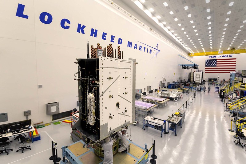
The U.S. Air Force’s third GPS III satellite in production flow at Lockheed Martin’s advanced satellite manufacturing facility in Denver is now fully integrated into a complete space vehicle.
GPS III Space Vehicle 03 (GPS III SV03) followed the first two GPS III satellites on a streamlined assembly and test production line. Technicians successfully integrated the satellite’s major components — its system module, navigation payload and propulsion core — into one fully assembled space vehicle on Aug. 14.
GPS III SV03 was assembled in Lockheed Martin’s GPS III Processing Facility, a $128 million, cleanroom factory designed in a virtual reality environment to drive efficiency and reduce costs in satellite production. Now fully assembled, the third satellite is being prepared to begin environmental testing.
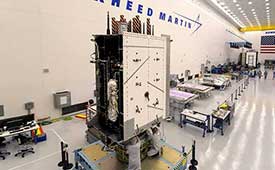
GPS III SV03 is scheduled to launch on June 30. (Photo: Lockheed Martin)
GPS III SV03 closely follows the company’s second satellite in production flow. GPS III SV02 completed integration in May, finished acoustic testing in July and moved into thermal vacuum testing in August. The second GPS III satellite is expected to be delivered to the U.S. Air Force in 2018.
The fourth GPS III satellite is close behind the third. Lockheed Martin received the navigation payload for GPS III SV04 in October and the payload is now integrated with the space vehicle. The satellite is expected to be integrated into a complete space vehicle in January 2018.
In August, Lockheed Martin technicians began major assembly work on GPS III SV05.
All of these satellites are following Lockheed Martin’s first GPS III satellite, GPS III SV01, through production flow. In September, the Air Force accepted and declared GPS III SV01 “available for launch,” with launch expected in 2018.
“GPS III is the most powerful and complex GPS satellite ever designed and built, and it’s now into a smooth production flow,” said Mark Stewart, Lockheed Martin’s vice president for navigation systems. “The real credit goes to the Air Force for all the Back to Basics work done in advance, reducing program risk for all the GPS III satellites going forward. We are looking forward to bringing GPS III’s advanced capabilities to our warfighters in 2018.”
Lockheed Martin is under contract for 10 next-generation GPS III satellites as part of the Air Force’s modernized GPS. GPS III will have three times better accuracy and up to eight times improved anti-jamming capabilities. Spacecraft life will extend to 15 years, 25 percent longer than the newest GPS satellites on-orbit today. GPS III’s new L1C civil signal also will make it the first GPS satellite to be interoperable with other international global navigation satellite systems.
Lockheed Martin’s unique GPS III satellite design includes a flexible, modular architecture that allows for the insertion of new technology as it becomes available in the future or if the Air Force’s mission needs change. Satellites based off this design are already proven compatible with both the Air Force’s next generation Operational Control System (OCX) and the existing GPS constellation.
The GPS III team is led by the GPS Directorate at the U.S. Air Force Space and Missile Systems Center. Air Force Space Command’s 2nd Space Operations Squadron (2SOPS), based at Schriever Air Force Base, Colorado, manages and operates the GPS constellation for both civil and military users.
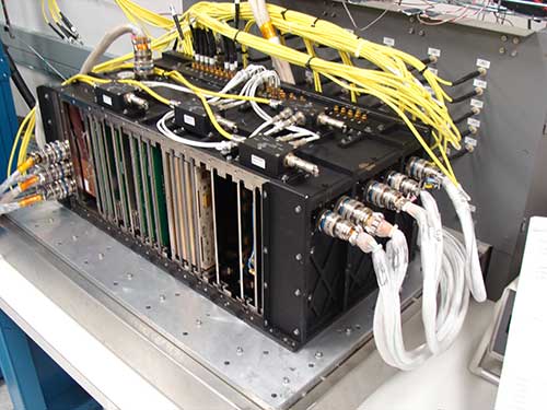
Harris Corporation has completed development of its fully digital Mission Data Unit (MDU), which is at the heart of its navigation payload for Lockheed Martin’s GPS III satellites 11 and beyond.
The current Harris payload for GPS III space vehicles (SVs) 1-10 includes a greater than three times reduction in range error, up to eight times increase in anti-jamming power, added signals — including one compatible with other Global Navigation Satellite Systems (GNSS) — and greater signal integrity.
The fully digital Mission Data Unit (MDU) will create precise civil and military timing navigation signals for GPS III satellites 11 and beyond. Pictured here is the advanced MDU on navigation payloads being delivered for GPS III Space Vehicles 1-10. (Photo: Harris)
Harris’ GPS III SV11+ fully digital navigation payload will further improve on performance for the U.S. Air Force by providing more powerful signals, plus built-in flexibility to adapt to advances in GPS technology, as well as future changes in mission needs.
“This design is fully mature — an Engineering Development Model, not a prototype — and is ready to be inserted into GPS III SV11+,” said Bill Gattle, president, Harris Space and Intelligence Systems. “The payload has the flexibility to serve the warfighter over the entire mission life and can be upgraded incrementally over its mission life due to built-in adaptability.”
Harris navigation payloads are already integrated in the second GPS III space vehicle, pictured here, and the first GPS III satellite, declared available to launch in 2018. (Photo: Lockheed Martin)
The payload design also ensures flawless atomic clock operations, providing the reliable GPS signal that millions of people — including U.S. soldiers — and billions of dollars in commerce depend on every day, the company said. It also will provide the clock signal for a new GPS III Search and Rescue (SAR) payload.
Beyond flexibility and reliability, the new Harris SV11+ navigation payload offers a smooth transition to the Air Force’s GPS OCX ground control segment. The Harris payload for the first ten GPS III satellites already has been verified for OCX compatibility, and this will allow Harris to seamlessly port the Harris SV11+ design, minimizing integration risks and associated costs.
The U.S. Air Force has declared the first Lockheed Martin-built GPS III satellite “available for launch,” (AFL) ushering in a new era of advanced GPS technology.
The Air Force’s “AFL” declaration is the final acceptance of Lockheed Martin’s first GPS III Space Vehicle (GPS III SV01) before its expected 2018 launch. GPS III SV01 will bring new capabilities to U.S. and allied military forces, and a new civil signal that will improve future connectivity worldwide for commercial and civilian users.
GPS III SV01 now awaits a call up to begin pre-launch preparations. In the meantime, the advanced satellite is stored in an environmentally controlled clean room, where engineers can perform maintenance and continue to service the satellite.
New GPS Capabilities
The U.S. Air Force declared the first Lockheed Martin-built, next-generation GPS III satellite “Available for Launch” in 2018. (Photo: Lockheed Martin)
GPS III SV01 is the first space vehicle of an entirely new satellite design. GPS III is a next generation technology and capability leap over any of the 31 GPS Block II satellites that currently populate today’s operational GPS constellation.
Better accuracy. For military forces, precision is essential. GPS III signals will provide them three times more accuracy than any current GPS satellites. How accurate is that? We cannot get specific, but stretch your arms out, we are within that range now.
Improved anti-jam. It is no secret that future adversaries will try to nullify tools like GPS that give our military an edge in conflicts. GPS III’s powerful new signals have eight times improved anti-jamming capability, and the satellites’ nearly 70 percent digital payload will provide the Air Force with greater operational flexibility.
Stronger design. Space is a tough neighborhood and GPS III is built tough. GPS III comes with a more resilient design and a design life which can expand its operational life to 15 years. That’s 25 percent longer than the newest GPS satellites on-orbit today.
New civil signal. GPS III will be the first GPS satellite broadcasting L1C, a new, common signal being adopted by other international Global Navigation Satellite Systems (GNSS), like Europe’s Galileo. In the future, users of civilian GPS receivers will be able to connect to L1C from multiple GNSS constellations, allowing for greater connectivity.
Designed for the Future
One of the keys to Lockheed Martin’s GPS III is it was designed for today’s mission with an eye on tomorrow’s needs.
“As we designed GPS III, we knew that mission needs would change in the future and that new technology will become available,” said Mark Stewart, vice president of Lockheed Martin’s Navigation Systems mission area. “We wanted the satellite to be flexible to adapt to those changes. To do that, we intentionally developed GPS III with a modular design. This allows us to easily insert new technology into our production line.”
Future satellites — already with a robust, production-ready design — also would benefit from the inherent risk-reductions already proven out in GPS III, like compatibility with OCX and the existing GPS constellation. Significant work has already been completed on future requirements like an accuracy-improving Laser Retro-reflector Array and a Search and Rescue payload.
For Lockheed Martin, the completion of GPS III SV01 is a major milestone on a challenging development program to design and build the most powerful GPS satellites ever envisioned. With all major development risks behind them, the company is now in full production on ten GPS III satellites at its GPS III Processing Facility near Denver.
“Lockheed Martin’s GPS III team owes much of its success to the Air Force’s Back to Basics program,” Stewart added. “We are proud to partner with the Air Force on this important program and look forward to launching the first GPS III satellite in 2018.”
The GPS III team is led by the Global Positioning Systems Directorate at the U.S. Air Force Space and Missile Systems Center. Air Force Space Command’s 2nd Space Operations Squadron (2SOPS), based at Schriever Air Force Base, Colorado, manages and operates the GPS constellation for both civil and military users.
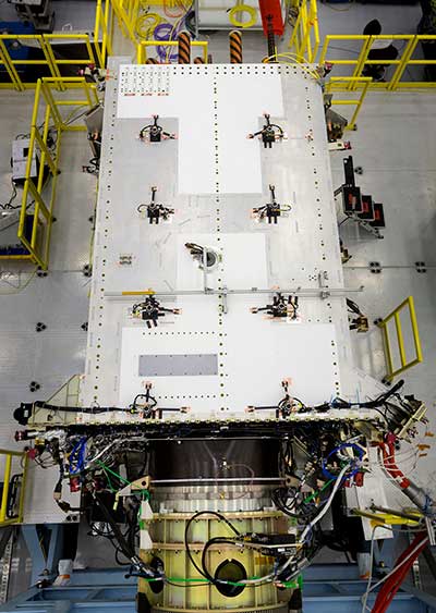
The Military Code (M-Code) Early Use (MCEU) contract will accelerate deployment of command and control of M-code capability to GPS IIR-M and GPS IIF satellites currently on orbit, as well as future GPS III satellites (like GPS III SV02 above). (Photo: Lockheed Martin)
The U.S. Air Force has awarded Lockheed Martin a $45.5 million contract to provide military code (M-code) early use (MCEU) capability to GPS.
MCEU will provide command and control of M-code capability to eight GPS IIR-M and 12 GPS IIF satellites on orbit, as well as future GPS III satellites, which the Air Force expects will begin launching in 2018.
MCEU is envisioned as a way to accelerate M-code’s deployment to support testing and fielding of modernized user equipment in support of the warfighter.
The U.S. Air Force’s MCEU contract directs Lockheed Martin to upgrade the existing Architecture Evolution Plan (AEP) Operational Control System (OCS), allowing it to task, upload and monitor M-code within the GPS constellation. The contract includes new software and hardware development that will be deployed in 2019 to worldwide ground facilities that support the Air Force’s GPS.
The AEP OCS — maintained by Lockheed Martin under the GPS Control Segment (GCS) Sustainment Contract — controls the 12 GPS IIR, 8 IIR-M and 12 IIF satellites in orbit today. The company has successfully implemented several recent projects to modernize and sustain the system for the Air Force.
U.S. Department of Defense units and university researchers gathered at Edwards Air Force Base, in California, to evaluate various aerial platforms in a degraded GPS environment. The week-long test event called Developmental Test Navigation Festival (DT NAVFEST) was the first large-scale program of its kind, according to James Cook, KC-46A project manager with the 418th Flight Test Squadron.
“DT NAVFEST was established to provide a locally more realistic GPS jamming environment in which aircraft platforms and unmanned aerial vehicles could evaluate their performance under a degraded GPS signal,” Cook said. “Other locations around the U.S. provide such environments, but having it locally allowed for direct program input and cost savings to customers by not having to deal with the logistics costs of deploying to those locations.”
Units that tested assets at Edwards included the Emerging Technologies Combined Test Force, the 411th, 416th, 419th and 461st Flight Test Squadrons, Stanford University, the University of Illinois, and the U.S. Army’s Special Operations Command. The GPS jammers and support came from the 746th Test Squadron at Holloman Air Force Base, New Mexico.
“Live GPS jamming data is extremely difficult for academic labs to obtain due to the complexity of working with the Federal Aviation Administration and regional first responders,” said Wei Lee, test safety engineer with the 412th Test Wing. “It is crucial that the Department of Defense support basic research and development that is ongoing in our nation’s top academic institutions. Many of the low-technology readiness-level projects will eventually migrate from academic labs to defense industry and military applications. Allowing the labs to participate on a non-interference basis is a win-win situation.”
The GPS jammers employed had a vertical reach of upwards of 30,000 feet.
The 746th Test Squadron from Holloman Air Force Base, New Mexico, provided an array of GPS jamming equipment and support for DT NAVFEST at Edwards Air Force Base. The jammers provided a degraded GPS environment for testing multiple aerial platforms throughout the week. Testing was done from 1 to 6 a.m. each day to minimize impact on the community and civilian air traffic. (Photo: U.S. Air Force/Cole Johnson)
IRNSS launch unsuccessful
A launch of a new Indian Regional Navigation Satellite System (IRNSS) satellite failed when the protective fairing did not separate. The 1425-kg satellite was expected to expand the existing seven satellites of the NavIC constellation. The launch vehicle PSLV-C39 lifted the satellite on Aug. 31.
The three phases of the launch went smoothly, but the heat shield that was supposed to be separated in the fourth stage could not be detached. IRNSS-1H was planned as a replacement satellite for IRNSS-1A.
The second Lockheed Martin GPS III satellite completes a test simulating a strenuous launch environment.
The launch is the most strenuous part of a satellite’s life. To survive the extreme sound wave pressure and pounding vibrations generated by more than 700,000 pounds of thundering rocket thrust, spacecraft need a solid, reliable design if they hope to arrive operational on orbit.
On July 13, Lockheed Martin’s second, fully assembled GPS III space vehicle (SV) completed a realistic simulation of its future launch experience and passed this critical acoustic environmental test with flying colors, the company said.
During acoustic testing, GPS III SV02 was blasted with deafening sound reaching 140 decibels in a specialized test chamber equipped with high-powered horns. (Photo: Lockheed Martin)
During acoustic testing, the GPS III SV02 satellite was continuously blasted with sound reaching 140 decibels in a specialized test chamber equipped with high-powered horns. For comparison, that is about as loud as an aircraft carrier deck and human hearing starts to be damaged back at about 85 decibels, the company said. The test uses sound loud enough to literally shake loose anything not properly attached.
“With this launch-simulation test, we are talking about sophisticated, advanced satellite technology and electronics enduring tremendous forces and then working flawlessly afterward,” said Mark Stewart, Lockheed Martin’s vice president for Navigation Systems. “Passing this test with GPS III SV02 further validates the robustness of our GPS III design. We credit this success and risk-retirement to all the pathfinding work we accomplished early in the program.”
The GPS III SV02 satellite is part of the U.S. Air Force’s next generation of GPS satellites and will bring critical new capabilities to the warfighter. GPS III will have three times better accuracy and up to eight times improved anti-jamming capabilities.
Spacecraft life will extend to 15 years, 25 percent longer than the newest GPS satellites on-orbit today. GPS III’s new L1C civil signal also will make it the first GPS satellite to be interoperable with other international global navigation satellite systems.
GPS III SV02 is Lockheed Martin’s second GPS III satellite to successfully complete acoustic testing. The company’s first satellite, GPS III SV01 — which is in storage awaiting its expected 2018 launch — completed acoustic testing in 2015.
The GPS III SV02 satellite is now being prepared for Thermal Vacuum (TVAC) testing this fall, where it will be subjected to extreme cold and heat in zero atmosphere, simulating its on-orbit life. The satellite is expected to be delivered complete to the Air Force in early 2018.
GPS III SV02 is the second of 10 GPS III satellites Lockheed Martin is contracted for and is assembling in full production at the company’s GPS III Processing Facility near Denver. The $128 million, state-of-the-art manufacturing factory includes a specialized cleanroom and testing chambers designed to streamline satellite production.
Lockheed Martin’s GPS III satellite design includes a flexible, modular architecture that allows for the insertion of new technology as it becomes available in the future or if the Air Force’s mission needs change. Satellites based off this design are already proven compatible with both the Air Force’s next generation Operational Control System (OCX) and the existing GPS constellation.
QZS-2 L-band spectra, July 18, 2017, Weilheim, Germany. (Courtesy DLR)
Second QZSS Signal on Air
The successful launch of the Michibiki No. 2 satellite of the Quasi-Zenith Satellite System (QZSS) on June 1 has been followed by broadcast initiation. Researchers at the German Aerospace Center, Deutsches Zentrum für Luft- und Raumfahrt (DLR), have been observing the satellite from their ground station in Weilheim. They will provide a written analysis in the September issue.
The Japan Aerospace Exploration Agency launched first Michibiki satellite of the anticipated four-satellite constellation in September 2010.
Air Force to Recompete GPS III Follow-on
The U.S. Air Force will launch multibillion-dollar competition between current GPS III contractor Lockheed Martin Corp. and former GPS Block I and Block II contractor Boeing Co. for as many as 22 new GPS III satellites. At press time, an industry day in was scheduled for July 20 in El Segundo, California, to solicit company input, according to a new draft Request For Proposals.
In 2015 the Air Force undertook the first phase of a now two-year process to determine whether to put the next block of satellites up for competition. An initial review “has determined that viable, low-risk, high-confidence sources exist to conduct a full and open competition” for a second phase starting in fiscal 2018, according to the draft.
Lockheed Martin is assembling the first 10 satellites of the Block III program. Formal delivery of the first satellite was scheduled earlier this year, delayed by of a series of now-resolved problems with the navigation payload, cracked capacitors and a subcontractor gaffe last year that resulted in the wrong part being tested.
The satellite, which passed all of its qualification testing and verification, has been placed in storage pending the results of an unrelated review of the propulsion systems used to boost military satellites into orbit. The plan remains to launch the first GPS III satellite by spring of 2018.
“Lockheed Martin is working closely with the Air Force on resolving any concerns about the mission readiness of SV01’s Propulsion Subsystem,” Eschenfelder said in February. “We are confident that this review will not delay the Air Force’s planned spring 2018 Initial Launch Capability (ILC).”
NAVIC Clock Failures Resemble Galileo’s
The seven orbiting satellites of the Navigation Indian Constellation (NAVIC, formerly India’s Regional Navigation Satellite System, or IRNSS) have been hit by problems with some of their rubidium atomic clocks, similar to difficulties encountered earlier by Europe’s Galileo program.
NAVIC G-1 launch April 2017.
The Indian Space Research Organization (ISRO) had announced in July 2016 that all three atomic clocks on IRNSS-1A, launched in 2013, had malfunctioned, rendering that satellite ineffective.
Now, reports indicate that four more atomic clocks on the other six satellites launched more recently are not performing as required.
ISRO plans to launch a replacement satellite called IRNSS-1H in July-August to compensate for the loss of IRNSS-1A, although it is yet to announce the failure of more atomic clocks, which has not incapacitated the clock systems on the other six satellites.
The European Space Agency reported in January that anomalies had occurred in three of 36 Rubidium Atomic Frequency Standard (RAFS) clocks in the 18-satellite Galileo system, although none of the satellites were affected. ESA had said, “These failures all seem to have a consistent signature, linked to probable short circuits, and possibly a particular test procedure performed on the ground.”
ISRO has nine satellites indented for IRNSS. While seven satellites make up the Indian regional navigation constellation, the other two were indented as backup in the event of failure. Each satellite has three atomic clocks, one the primary timekeeper and the other two acting as backup.
“Measures are being taken to correct the problems caused by the clocks in the launch of future satellites. The atomic clocks to be used in the other satellites have been modified to prevent malfunction,” a senior official in the programme said.
ISRO chairman Kumar has indicated the number of satellites could go up from the originally envisaged seven to 11 but it is not clear if this is a consequence of the failing clocks. “We are set to launch more navigational satellites. They are in the process of approvals and clearances,” he said recently, and added efforts were on to revive the IRNSS-1A clocks.”
In Europe, the European Space Agency and an industrial partner-supplier have agreed that “some refurbishment is required on the remaining RAFS clocks” to be used in new Galileo satellites.
Look to GSA Service Centre for Galileo Advisories
In July, a wide transfer of responsibilities for the Galileo constellation took place, from the European Space Agency (ESA) to the European Global Navigation Satellite System Agency (GSA) of the European Union. Key among these was a handover of communications responsibilities to manufacturers, users and markets.
All parties can now find updates in the form of Notice Advisory to Galileo Users (NAGUs) at the GSA’s Galileo Service Centre, www.gsc-europa.eu/system-status/user-notifications.
NAGUs are issued as new satellites are launched and when satellites become ready for service provision, or to give advance warning of signal unavailability owing to planned maintenance or testing activities, or to notify users of unplanned outages and then to inform them when satellites become active again.
“Keeping our users in the picture on planned activities that might lead to satellite unavailabilityhas helped them to plan their own test activities and to prepare future products,” said Rafael Lucas Rodriguez, ESA’s Galileo services engineering manager.
A total of 189 NAGUs were issued under ESA oversight in the last four years, as the constellation grew to its current 18 satellites. The user base increased from 86 to 774 registered users on the European GNSS Service Centre website as companies worked to prepare Galileo-ready products. In December 2016, Galileo’s Initial Services began operating.
One regular consumer of Galileo NAGUs, Broadcom, uses them to organize engineering activities and tests as well as input them into its orbit prediction engine for its Long Term Orbits products.
Three of six new Lockheed Martin-developed state-of-the-art receivers are now deployed to help the U.S. Air Force maintain the accuracy of GPS satellite signals.
In June, the first new Monitor Station Technology Improvement Capability (MSTIC) receiver became operational at Cape Canaveral Air Force Station, Florida. The upgrades continued at U.S. Air Force monitoring stations on the Kwajalein Atoll and Hawaii.
These critical upgrades of the GPS Monitoring Stations from early 1990s technology are part of an overall effort to modernize and maintain the current GPS ground control system, known as the Architecture Evolution Plan Operational Control Segment.
GPS monitoring stations are globally dispersed, fixed-position sites that monitor GPS satellite signals and help maintain their navigation and positioning accuracy for users around the world.
Under Lockheed Martin’s GPS Control Segment (GCS) Sustainment contract, the company used an agile development methodology to develop and deploy the first MSTIC receiver on schedule in under 36 months. The three remaining Air Force GPS Monitoring Stations will be upgraded with MSTIC receivers by the end of 2017.
“Taking advantage of current commercial technology trends has allowed us to provide the Air Force with a monitoring capability that can support the Air Force’s GPS mission for years to come,” said Vinny Sica, vice president and general manager of Mission Solutions for Lockheed Martin. “The MSTIC receiver addresses today’s obsolescence problem while providing the opportunity for the monitoring of modernized navigation signals in the future.”
The new MSTIC receiver’s software-defined radio (SDR) technology will replace the legacy monitor station receiver element (MSRE)’s hardware-based ASIC (application-specific integrated circuit) platform originally deployed almost two decades ago, Sica said.
MSTIC leverages commercial off-the-shelf hardware without the need for custom firmware. Standard interfaces and the inherent configurability of the architecture simplifies sustainment and enables MSTIC software to migrate to new hardware platforms as commercial vendors increase processing power, improve reliability and enhance cybersecurity, Sica said.
“MSTIC’s new SDR technology enables the remote application of mission specific software updates which will improve performance and enable reception of modernized GPS signals,” added Sica.
The GPS Directorate at the U.S. Air Force Space and Missiles Systems Center contracted the MSTIC upgrade. Air Force Space Command’s 2nd Space Operations Squadron (2SOPS), based at Schriever Air Force Base, Colorado, manages and operates the GPS constellation for both civil and military users.
Gen. David L. Goldfein, chief of staff of the Air Force, listens to 1st Lt. Mark Skinner, 2SOPS GPS mission commander, explain current 2SOPS activities during his visit to Schriever AFB Dec. 20, 2016. (U.S. Air Force photo/Christopher DeWitt)
Harris Corporation has delivered the third of 10 advanced navigation payloads to Lockheed Martin, which will increase accuracy, signal power and jamming resistance for U.S. Air Force GPS III satellites.
The navigation payload before integration into the second GPS III SV, which now is in environmental testing. (Photo: Harris)
The advanced navigation payloads feature a Mission Data Unit (MDU) with a unique 70-percent digital design that links atomic clocks, radiation-hardened computers and powerful transmitters — enabling signals three times more accurate than those on current GPS satellites.
The new payloads also boost satellite signal power, increase jamming resistance by eight times and help extend the satellite’s lifespan.
The payload is expected to be integrated into GPS III Space Vehicle 3 (GPS III SV03) this summer. In May, Harris’ second GPS III navigation payload was integrated into GPS III SV02.
The first navigation payload is integrated aboard GPS III SV01, which has now completed rigorous testing and is in storage awaiting its expected 2018 launch.
The MDU performs the primary mission of the GPS satellite, which is generation of the navigation signals and data that provide precise time information to users on a continuous basis. (Photo: Harris)
“We are now in full production and on target to deliver the fourth GPS III navigation payload to Lockheed Martin this fall,” said Bill Gattle, president, Harris Space and Intelligence Systems. “Our payloads help U.S. and allied soldiers complete their missions, enable billions of dollars in commerce and benefit the everyday lives of millions of people around the world.”
Harris has a long legacy of expertise in creating and sending GPS signals, extending back to the mid-’70s — providing navigation technology for every U.S. GPS satellite ever launched.
Harris is also developing a fully digital MDU for the U.S. Air Force’s GPS III Space Vehicles 11+ acquisition. This new MDU will be demonstrated in fall 2017 and provides even greater flexibility, affordability and accuracy versus existing GPS satellites.
Harris navigation payloads are already integrated in the second GPS III space vehicle, now in environmental testing, and the first GPS III satellite (pictured here), expected to launch in 2018. (Photo courtesy Lockheed Martin)
Preliminary construction is underway on a new, $350 million Lockheed Martin facility that will produce next-generation satellites.
The new facility, located on the company’s Waterton Canyon campus near Denver, is the latest step in an ongoing transformation, infused with innovation to provide future missions at reduced cost and cycle time, the company said.
The new Gateway Center, slated for completion in 2020, includes a state-of-the-art high bay clean room capable of simultaneously building a spectrum of satellites from micro to macro.
Spacecraft now in production at the site include the Air Force’s GPS III satellites (in the GPS III Processing Facility), NASA’s InSight Mars lander, NOAA’s GOES-R Series weather satellites and commercial communications satellites.
The facility’s paperless, digitally-enabled production environment incorporates rapidly-reconfigurable production lines and advanced test capability.
It includes an expansive thermal vacuum chamber to simulate the harsh environment of space, an anechoic chamber for highly perceptive testing of sensors and communications systems and an advanced test operations and analysis center.
The Gateway Center will be certified to security standards required to support vital national security missions.
“This is our factory of the future: agile, efficient and packed with innovations,” said Rick Ambrose, executive vice president of Lockheed Martin Space Systems. “We’ll be able to build satellites that communicate with front-line troops, explore other planets and support unique missions.”
“You could fit the Space Shuttle in the high bay with room to spare,”Ambrose said. “That kind of size and versatility means we’ll be able to maximize economies of scale, and with all of our test chambers under one roof, we can streamline and speed production.”
Lockheed Martin expects the construction effort to employ a total of 1,500 contractors during the three-year construction phase. Lockheed Martin has added more than 750 jobs to its Colorado workforce since 2014, and has about 350 job openings in the Denver area alone.
Lockheed Martin’s planned satellite integration facility, the Gateway Center, is slated for completion in 2020. (Photo: Lockheed Martin.}
The building will accommodate that recent growth and new future projects. State and local officials in Colorado have helped strengthen the aerospace industry and foster an environment that helps aerospace companies thrive and grow.
“Aerospace is an engine of innovation and growth for America, and we’re investing in infrastructure and technology to help strengthen the nation’s leadership in military and commercial space and scientific exploration,” added Ambrose. “We’re transforming every aspect of our operations to help our customers stay ahead of a rapidly-changing landscape. The Gateway Center, coupled with advancements in 3D printing, virtual reality design and smart payloads, will deliver game-changing innovations while saving our customers time and money.”
Lockheed Martin’s Waterton Canyon campus has been a hub of space innovation since the 1950s, with more than 4,000 employees and a wide range of industry-leading design, manufacturing and test facilities on site.
Companies selected by Lockheed Martin for the project include Hensel Phelps as the general contractor, Matrix PDM Engineering and Dynavac for thermal vacuum chamber design and construction, and ETS-Lindgren for anechoic chamber design and construction.