Aerial images from a drone are being evaluated as a method to survey seagrasses scarred by boat propellers.
The Texas Parks & Wildlife Department (TPWD) has partnered with Texas A&M University-Corpus Christi to determine if using unmanned aircraft systems is as effective as using planes.
Seagrasses serve as a refuge and nursery ground for fish, shrimp and crabs. They provide oxygen to the water column and serve as an area for growth of drift algae, a food source for shrimp, fish and crabs.
A law prohibiting the uprooting of seagrasses coast-wide was passed by the Texas Legislature during the 83rd legislative session and has been in effect since September 2013. Motorboats cause propeller scarring when they drift into shallow waters and tear a trough in the bay bottom.
Michael Starek, assistant professor of engineering, has been analyzing the images and data collected from flights in December of a small UAS about 450 feet above Redfish Bay’s seagrasses.
TPWD has conducted aerial surveys since 2007 using piloted aircraft flying at an altitude of about 2,000 feet, said Faye Grubbs, Upper Laguna Madre ecosystem leader with TPWD.
The project will compare the output from each method, and analyze costs of processing and ease of mobilization.
TPWD continues to collect aerial imagery in four areas along the Texas coast to evaluate the effects of the regulation. Based on the outcome of this project, Grubbs said the department may use drones for not only monitoring changes in propeller scarring, but possibly for mapping other habitats as well.
“We are comparing the accuracies of the different imagery sets — manned versus unmanned — and how well we are able to map scar features observed in the imagery,” she said.
UAS-collected imagery has the potential to change environmental monitoring at many scales, not just in coastal regions, Starek said.
The first step is to show drone-captured data is comparable to that collected from manned planes. University researchers have been doing just that for several years, flying along the coast and comparing drone-captured images to data from on-the-ground and in-the-water surveying by traditional means.
One of the biggest challenges with aerial imaging of the sea floor is weather and water clarity, Starek said.
“This experiment showed that with proper flight planning for weather conditions, mapping of prop scars with a small UAS can be a viable alternative to more costly, piloted airborne surveys,” Starek said. “Results from the flights show impressive spatial fidelity in the UAS-collected imagery. Pixel resolutions down to one inch will allow mapping of seagrass impacted by prop scaring at very fine spatial detail previously unattainable.”
Although the results show the capabilities, Starek said UAS technology still has to evolve both in platform endurance and in regulations to allow these systems to fly autonomously over much larger areas, such as an entire bay system. This latter component will evolve as the technology and confidence in its use matures.
“In the not too distant future, I can foresee the day when a fleet of small UAS equipped with cameras can routinely map an entire bay system at a fraction of the cost for traditional piloted airborne surveys,” he said. “The potential for UAS technology is immense.”
The AirMap Digital Notice and Awareness Dashboard(TM) airport manager view.
AirMap and the American Association of Airport Executives (AAAE) have released the Digital Notice and Awareness System (D-NAS), created to allow UAS operators to provide airports with real-time digital information about the location of their flights.
AirMap is a provider of airspace information and services for unmanned aircraft. On April 7, the company announced that it raised a $15 million Series A financing led by General Catalyst Partners to accelerate its global development airspace management tools for drones.
D-NAS works by allowing a UAS operator to send an encrypted digital flight notice to a secure dashboard at an airport’s operations center. Flight information can be submitted through various UAS interfaces, including the flying apps provided by drone manufacturers DJI, Yuneec and 3DRobotics.
These connections facilitate the transmission of important safety-critical information to airports, including the GPS location of the UAS flight. Participating airports will access this information through the AirMap D-NAS dashboard, which provides a map view of flights in proximity to the airport and the option to contact the UAS operator directly.
“Safety has always been a priority for DJI,” said Brendan Schulman, DJI’s vice president of Policy and Legal Affairs. “Providing our customers the capability to easily notify nearby airports of their flights is a huge step forward in convenience and functionality. A high-tech notification system complements the safety features DJI builds into every drone, as well as DJI’s close work with policymakers on practical approaches for drone technology.”
More than 50 airports across America have already joined the D-NAS pilot program, including Houston’s George Bush Intercontinental and William P. Hobby airports, Denver International Airport, Columbus Air Force Base in Mississippi, Charlotte-Douglas Airport in North Carolina, Reno-Tahoe Airport in Nevada, New Castle Airport in Delaware, Cape May Airport in New Jersey, Fairbanks International Airport in Alaska, and the Oxnard and Camarillo Airports in Ventura County, California.
The AirMap Digital Notice and Awareness Dashboard map view.
“Participation in the D-NAS pilot was a no-brainer for us. In the face of growing concerns over UAS operations near airports, AirMap has developed an effective and unique solution,” said Steve Runge, Division Manager for the Houston Airport System. “D-NAS is a game changer for how we will manage low altitude air safety.”
D-NAS not only provides heightened awareness to airports; it also makes it easier for UAS operators to comply with Section 336 of the FAA Modernization and Reform Act of 2012, which requires notice to be given to airports within five miles of a drone’s flight location.
Ben Marcus, CEO of AirMap and an airline transport rated pilot and flight instructor, said, “Everyone involved in aviation sees the promise and potential of unmanned aircraft. However, we can’t reach the potential of this amazing technology unless we ensure that safety critical information keeps pace with innovation. We are focused on building the tools for unmanned aircraft to safely integrate into the national airspace system.”
“We are excited to work with AirMap to improve the safety features of our products,” said Yuneec CEO Tian Yu. “As an airplane and helicopter pilot myself, I know first-hand how important it is to keep the national airspace system safe.” Yuneec is the manufacturer of the Typhoon and Tornado series of multirotor drones and recently announced a $60M investment from Intel.
TerraGo has released TerraGo Edge 3.9.3, which features full support for OGC GeoPackage, a universal format for sharing maps and geographic data across mobile devices and all platforms.
TerraGo Edge enables users to import and export OGC GeoPackage as a SQLite database optimized for performance on iOS and Android devices.
“Because we listened to our customers, we designed TerraGo Edge from the ground up to be an open solution for exchanging field engineering, GIS, GPS and asset management data across vendor platforms and devices,” said John Timar, vice president, Worldwide Sales at TerraGo. “GeoPackage is an important win for customers because it’s a dramatic shift away from proprietary formats and technology. GeoPackage breaks through user dependence based on vendor data lock-in, enables platform-independent data exchange and refocuses customer value on software features and performance.”
The latest TerraGo Edge 3.9.3 release closes the loop for a complete GeoPackage collaboration workflow by allowing Edge app users to import GeoPackage data from a mobile device, collect location-tagged field data and roundtrip the information back to the GIS or other enterprise systems of record.
BYOD GPS Gets Real: Lessons Learned with the New Rules of GPS Data Collection
Thursday, April 14, 1 p.m. ET / 10 a.m. PT
In this GPS World webinar, join us as we examine how five organizations from five industries (oil & gas, engineering, water utility, transportation and natural resources) made the switch from GPS handhelds to smartphones and tablets for their field data collection needs. Speakers are Michael Gundling and David Basil, TerraGo.
Version 3.9.3 features these enhancements:
Advanced GIS Integration
Deliver GeoPackage data to any TerraGo Edge mobile app user
Create offline map when GeoPackage is embedded in a GeoPDF
Simultaneously import GeoPDF and GeoPackage data back to Edge server
Improved Mapping Experience with EdgeMap Optimizer
Automatic detection of best resolution (DPI) for offline maps upon import by mobile user
Manually select the optimal resolution upon import
Data collection enhancements with the New Form Template Selection, including a new search function in form fields to improve user productivity and data integrity.
INRIX Inc., a connected car services and movement analytics company, has released a redesigned version of INRIX Traffic for iOS and Android.
INRIX Traffic is a next-generation navigation and traffic app that learns user preferences to take the guesswork out of driving. The app integrates with a user’s calendar and learns their driving habits to create a personalized itinerary that includes automatic alerts, anticipated trips, favorite destinations and preferred routes.
Available worldwide now in the Apple App Store and Google Play, INRIX Traffic learns routines and preferences as users go about their day. INRIX Traffic adds favorite places automatically instead of requiring users to spend time inputting destinations such as home, work or school.
Based on learned activities, it creates a daily, driver-specific itinerary of anticipated trips, as well as frequent and preferred routes. By accessing calendar information on a mobile device, the app also adds events with addresses to the daily driving itinerary.
Unlike other driving apps that can provide inaccurate traffic and incidents based purely on consumer input, INRIX Traffic uses a massive crowd-sourced network of more than 275 million connected cars and devices to offer accurate map and real-time information.
INRIX Traffic proactively monitors road conditions to alert drivers of ideal departure times, changes to arrival times and optimal routes to frequent or scheduled destinations based on real-time traffic.
“We designed INRIX Traffic with one specific vision: To help drivers move through their daily lives as quickly and efficiently as possible. The app uses our advanced traffic science to make even routine trips easier,” said Bryan Mistele, president and CEO, INRIX. “Users want an app that is accurate, personalized and smart enough to work proactively for them — so we’ve integrated several highly advanced technologies into one all-encompassing app.”
INRIX Traffic uses the crowd-sourced and free OpenStreetMap (OSM) for map data. By leveraging the power of user-generated content around the world, OSM can quickly adapt to the ever-changing road network. Using OSM enables INRIX to bring a high-quality map and turn-by-turn navigation to users at no cost and without advertisements. In addition to reporting incidents along their route including accidents, police activity and road hazards, INRIX Traffic users can send map feedback directly from the app.
INRIX Traffic is powered by the same technologies the company delivers to its automotive customers such as Audi, BMW, Lexus, Mercedes-Benz and Porsche. These connected car services include real-time and predictive traffic, off-street parking information and drive-time alerts. INRIX will continue integrating features from its product portfolio into future versions of INRIX Traffic.
INRIX Traffic is available in eight languages in 16 countries across North America and Europe, including Canada, France, Germany, Spain, United Kingdom and United States, with additional countries coming soon.
The app is built on Autotelligent, the company’s new software development kit and integrated cloud platform that provides machine learning and route monitoring. Autotelligent can be integrated into products in multiple industries such as automotive, enterprise and mobile.
A new recommended practice has been issued for GIS and mapping professionals responding to an oil spill.
The document — the final report of a joint project — guides professionals in using GIS technology and geospatial information to form a “common operating picture” for a spill response, so various organizations can deal with it effectively.
According to the report, the 2010 Deepwater Horizon spill in the Gulf of Mexico showed the need for a coordinated response based on timely geographic data.
The International Association of Oil & Gas Producers (IOGP) through the Geomatics Committee and IPIECA (the global oil and gas industry association for environmental and social issues) issued the recommended practice in cooperation with the Open Geospatial Consortium (OGC) and Resource Data.
Officially named the OGC IOGP/IPIECA Recommended Practice for a Common Operating Picture for Oil Spill Response, the document is the final report of the IOGP/IPIECA Joint Industry Project to produce a recommended practice for GIS/mapping in support of oil spill response and for the use of GIS technology and geospatial information in forming a Common Operating Picture (COP) for management of the response.
“The report lays the groundwork for coordinated activities by multiple stakeholders that need to come together quickly to respond to a spill,” said Rob Cox, Technical Director, IPIECA. “Having the report endorsed as an OGC Best Practice gives it the authority it needs to act as a focal point in support of that coordination.”
As stated in the report:
“Responding to an oil spill requires access to and understanding of many types of information. Effective, coordinated operations for the response are based on a shared, common picture of the situation. Interoperability provides shared situational awareness of the crisis and the response activities. What is needed is a common picture of reality for different organizations that have different views of the spill so that they all can deal with it collectively.
“Recent oil spills have provided lessons learned and recommendations on forming a Common Operating Picture for oil spill response. Through a joint project, industry is responding to the call, moving from recommendations to reusable best practices supported by open standards that can be deployed quickly in any region of the globe.
“This architecture report is part of the IOGP and IPIECA Oil Spill Response – Joint Industry Project (IOGP–IPIECA OSR-JIP) to produce a recommended practice for GIS/mapping in support of oil spill response and for the use of GIS technology and geospatial information in forming a Common Operating Picture to support management of the response.”
About the players
The Open Geospatial Consortium (OGC) is an international consortium of more than 515 companies, government agencies, research organizations, and universities participating in a consensus process to develop publicly available geospatial standards. OGC standards support interoperable solutions that “geo-enable” the Web, wireless and location-based services, and mainstream IT. OGC standards empower technology developers to make geospatial information and services accessible and useful with any application that needs to be geospatially enabled.
The International Association of Oil & Gas producers (IOGP) is a unique global forum in which members identify and share best practices to achieve improvements in every aspect of health, safety, the environment, security, social responsibility, engineering and operations. IOGP encompasses most of the world’s leading publicly-traded, private and state-owned oil & gas companies, industry associations and major upstream service companies. IOGP members produce more than half the world’s oil and about one third of its gas.
IPIECA is the global oil and gas industry association for environmental and social issues. IPIECA was formed in 1974 following the launch of the United Nations Environment Programme (UNEP). IPIECA is the only global association involving both the upstream and downstream oil and gas industry on environmental and social issues. IPIECA’s membership covers over half of the world’s oil production. IPIECA is the industry’s principal channel of communication with the United Nations. When IPIECA was set up in 1974 the acronym stood for the International Petroleum Industry Environmental Conservation Association. In 2009, recognizing that this no longer accurately reflected the breadth and scope of the association’s work, IPIECA stopped using the full title. The association is now known as IPIECA, the global oil and gas industry association for environmental and social issues.
Resource Data, Inc. (RDI) has been supporting the oil & gas industry with information technology for spill response since 1989. RDI brings unparalleled experience to oil spill response, leading the geographic information system (GIS) and database teams for the Exxon-Valdez spill and more recently the GIS response team in the Macondo/Deepwater Horizon spill. RDI has developed numerous spill response data systems, participated in multiple drills, and developed risk analysis systems for major pipeline networks. Our depth and breadth of expertise in spill preparedness and response uniquely positions RDI to assist in the development of a Common Operating Picture for the oil and gas industry.
Woolpert has signed a five-year, multimillion-dollar Geospatial Product and Services Contract 3 (GPSC 3) with the U.S. Geological Survey (USGS) to provide mapping and surveying services.
The GPSC is a suite of contracts used by federal, state and municipal government entities to partner with USGS for the purpose of fulfilling their geospatial data requirements.
The contract will be administered through the National Geospatial Technical Operations Center (NGTOC) in an effort to obtain geospatial data services throughout the United States and its territories. The contract also will be used to support the 3D Elevation Program (3DEP) and used by other federal, state and local agencies.
“This provides Woolpert with the opportunity to continue working with USGS on their 3D Elevation Program (3DEP), an eight-year program to provide highly accurate 3D elevation data of the entire U.S.,” said John Gerhard, Woolpert project director. “This data will be collected via lidar (light detection and ranging) to create the most accurate surface model, and will be used to evaluate flood risk and natural resources, support FEMA, help farmers with precision agriculture, assess and manage infrastructure, and much more.”
Jeff Lovin, Woolpert senior vice president and director of government solutions, said the Woolpert staff is proud to have had the opportunity to work with the USGS for nearly 25 years. “Over those 25 years, we’ve had the opportunity to collaborate on different layers of the National Spatial Data Infrastructure (NSDI), from the development of nationwide imagery in the 1990s to 3D elevation and hydrography today,” Lovin said.”It’s very gratifying to have the opportunity to play a part in such an important program for our nation.”
Unmanned aerial vehicle maker DJI has launched the Phantom 4, a quadcopter drone that uses highly advanced computer vision and sensing technology to make professional aerial imaging easier.
The Phantom 4 expands on previous generations of DJI’s Phantom line by adding on-board intelligence that make piloting and shooting great shots easier through features such as its Obstacle Sensing System, ActiveTrack and TapFly functionality.
“With the Phantom 4, we are entering an era where even beginners can fly with confidence,” said DJI CEO Frank Wang. “People have dreamed about one day having a drone collaborate creatively with them. That day has arrived.”
The Phantom 4’s Obstacle Sensing System features two forward-facing optical sensors that scan for obstacles and automatically direct the aircraft around impediments when possible, reducing risk of collision, while ensuring flight direction remains constant.
If the system determines the craft cannot go around the obstacle, it will slow to a stop and hover until the user redirects it. Obstacle avoidance also engages if the user triggers the drone’s “Return to Home” function to reduce the risk of collision when automatically flying back to its take off point.
With ActiveTrack, the Phantom 4 allows users running the DJI Go app on iOS and Android devices to follow and keep the camera centered on the subject as it moves by tapping the subject on their smartphone or tablet. Perfectly framed shots of moving joggers or cyclists, for example, only require activating the ActiveTrack mode in the app.
The Phantom 4 understands three-dimensional images and uses machine learning to keep the object in the shot, even when the subject changes its shape or turns while moving. Users have full control over camera movement while in ActiveTrack mode — and can move the camera around the object while it is in motion as the Phantom 4 keeps the subject framed in the center of the shot autonomously. A “pause” button on the Phantom 4’s remote controller allows the user to halt an autonomous flight at any time, leaving the drone to hover.
By using the TapFly function in the DJI Go app, users can double-tap a destination for their Phantom 4 on the screen, and the Phantom 4 calculates an optimal flight route to reach the destination, while avoiding any obstructions in its path. Tap another spot and the Phantom 4 will smoothly transition towards that destination making even the beginner pilot look like a seasoned professional.
The Phantom 4’s camera, an aerial-optimized 4K imaging device, has undergone an upgrade that includes improved optics for better corner sharpness and reduced chromatic aberration. The Phantom 4 also has DJI’s signature Lightbridge video transmission system onboard, allowing users to see what their camera sees in HD and in real-time on their smart devices at a distance up to five kilometers (3.1 miles).
The Phantom 4’s form factor, the classic quadcopter, has been redesigned and redefined to emphasize elegance and smoother, more aerodynamic lines. Its frame incorporates a lightweight composite core to provide enhanced stability and more agile flight. The core features a redesigned gimbal that provides more stability and vibration dampening, and has been repositioned for a better center of gravity and to reduce the risk of propellers getting in the shot.
Refinements to motor efficiency, power management and a new intelligent battery have extended the Phantom 4’s flight time to 28 minutes, which means more time in the air to capture professional photos and video.
DJI crafted the Phantom 4 with reliability in mind, including redundant inertial measurement units (IMUs) and dual compasses onboard. It uses new push-and-lock propellers that are faster to install and more secure in flight.
In addition to intelligence and ease-of-use, the Phantom 4 is built for fun, DJI said. Its new “Sport Mode” for advanced flyers gives a taste of what drone racing feels like. In “Sport Mode,” the Phantom 4 can fly 20 meters per second (45 miles per hour) and ascends and descends more rapidly than in other modes. The craft’s acceleration and top speed in “Sport Mode” also mean it can reach locations for shots faster and capture shots users couldn’t get before.
“Though the Phantom 4 is easy to use, let’s not forget it is a high-performance aircraft powered by unparalleled DJI technology,” said Senior Product Manager Paul Pan.
Mobileye, a developer of vision and data analysis for Advanced Driver Assistance Systems (ADAS) and autonomous driving, has introduced a new mapping technology development called Road Experience Management (REM).
REM enables crowd-sourced real-time data for precise localization and high-definition lane data that forms an important layer of information to support fully autonomous driving.
Mobileye is engaged with General Motors to integrate REM into existing program launches in an expedited timeframe, as part of GM’s heightened partnership with Mobileye. In addition, on Jan. 5, Mobileye signed a Memorandum of Understanding with Volkswagen and announced a strategic partnership to explore and integrate REM into Volkswagen’s fleet.
The technology is based on software running on Mobileye’s EyeQ processing platforms that extracts landmarks and roadway information at extremely low bandwidths, approximately 10 kb per kilometer of driving. Additionally, backend software running on the cloud integrates the segments of data sent by all vehicles with the on-board software into a global map.
“We leveraged advanced artificial intelligence, used for creating environmental models from camera input, in order to create maps based on local coordinate systems while requiring very low bandwidth,” said Prof. Amnon Shashua, co-founder, chairman and Chief Technology Officer of Mobileye. “The low bandwidth of the model, and the fact that it requires only a camera, which is already available in most new car models as part of the trend towards growing driver assistance deployment, enables the map creation and update to be managed by a cooperative crowd sourcing mechanism.”
A third OEM customer of comparable size is expected to be announced later this year.
Shashua discussed the future of autonomous driving and road mapping at the Consumer Electronics Show in Las Vegas in January.
Epson recently announced in a news release the launch of its Pro G7000-Series large venue projectors for simulators, mapping, digital signage and command centers.
New features include increased brightness and motorized lenses, uncompromising image quality, low total cost of ownership and $199 replacement lamps, Epson says. Eight models deliver up to 8,000 lumens of color brightness and 8,000 lumens of white brightness.
The series also features the world’s first zero-offset ultra short-throw lens with 0.35 throw ratio for space constrained venues and digital signage applications. The Pro G-Series will be on display at ISE 2016 in Amsterdam from Feb. 9–12 at Epson’s booth, No. 1-H90.
“The Epson Pro G-Series offers bright, brilliant images combined with advanced features, making them our best-selling large venue projectors,” said Phong Phanel, product manager of large venue projectors, Epson America Inc. “The new Pro G7000-Series raises the bar with higher brightness, 4K Enhancement resolution, new motorized lenses and advanced technology to captivate any audience, underscoring our commitment to delivering a broad portfolio of solutions to the large venue projector market.”
Epson projectors offer three times higher color brightness than competitive 1-chip DLP models to ensure vivid colorful images. The Pro G Series 3-chip 3LCD projectors are ideal for large venues, including events staging, auditoriums and sanctuaries.
The Epson Pro G7000-Series will be available in May starting at $3,799 MSRP. The projectors come with a three-year limited warranty with next business day replacement, including free shipping both ways7, and a 90-day limited lamp warranty.
The color brightness specification — measuring red, green and blue — published by the Society for Information Display (SID) allows consumers to compare projector color performance without conducting a side-by-side shootout.
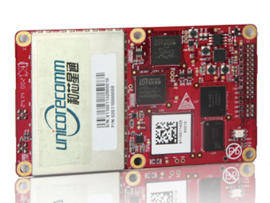
The UB380 GPS/GLN/BDS tri-constellation octa-frequency high-precision board.
High-end GNSS board
For high-precision positioning, navigation and GBAS applications
The UB380 multi-GNSS receiver has 384 channels, based on Unicore’s multi-GNSS system on a chip. It features Unicore’s latest real-time kinematic (RTK) engine, which can process triple-frequency BDS and GPS and dual-frequency GLONASS observation data. This can significantly reduce initialization time, improve position accuracy and enhance reliability in difficult environments such as city canyon and canopy, as well as make the long baseline RTK possible. The receiver board can support GPS L1, L2 and L5; GLONASS L1, L2; and BDS B1, B2 and B3. The support of GPS L2P and L2C can satisfy the high-precision requirements of GBAS reference station equipment. The UB380 is compatible with industry-standard GNSS boards in size, interfaces and electrical standards.
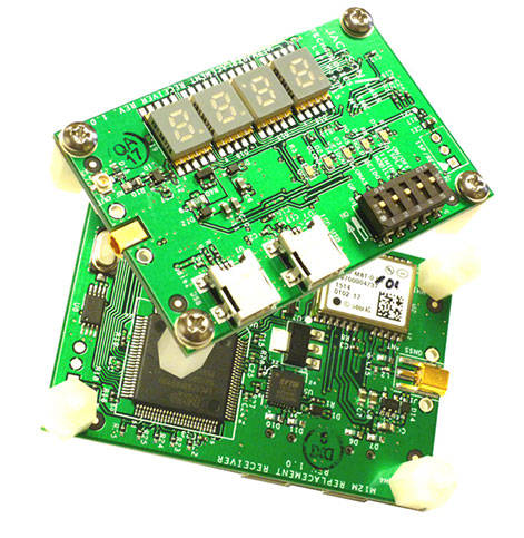
M12M Replacement Receiver GNSS module. Photo: Jackson Labs Technologies
Legacy receiver module
Plug-and-play upgrade for xli server, fury GPSDO
The M12M Replacement Receiver released is form, fit and function compatible to the legacy Motorola M12M and M12+ timing and navigation receivers. It uses an eighth-generation GNSS timing-enabled receiver, allowing 72 GNSS-channel reception with any two GNSS systems being received simultaneously. It adds configurability via USB ports and dual in-line package (DIP) switches and various status displays. GPS, GLONASS, BeiDou, QZSS and SBAS signals can be received. The module supports NMEA, Motorola binary and u-blox binary as well as SCPI (GPIB) communication protocols; is designed to allow plug-and-play retrofit of equipment designed for legacy Motorola receivers; and is certified as a plug-and-play upgrade to the Symmetricom/Microsemi XLI server and the Jackson Labs Technologies Fury GPSDO. It can be used to retrofit products for GLONASS/BeiDou compatibility. The module enhances performance parameters such as time to first fix; position, velocity and timing accuracy; tracking sensitivity; the addition of SBAS (differential compensation) capability; and the addition of external interfaces such as USB and a synthesized frequency output.
High-gain, high-rejection family designed for cell and telecom
The TW3150/52 antennas feature a 50-dB low-noise amplifier (LNA) gain to handle long cable runs often associated with installation on telecommunications towers. They cover the GPS L1 and SBAS (WAAS, EGNOS and MSAS) frequency bands and provide excellent cross-polarization rejection and enhanced multipath rejection.The TW3150 antenna features a four-stage dual-filtered LNA, while the TW3152 antenna includes an additional SAW pre-filter. This provides better than 80-dB of signal rejection above 1610 MHz and below 1545 MHz. The antennas are IP67 and MIL-STD-801F Section 509.4 compliant to withstand challenging environmental conditions.
Provides support for GPS, GLONASS and BeiDou with MediaTek
The ORG1510-MK Multi Micro Hornet is a fully integrated multi-GNSS (GPS, GLONASS and BeiDou) module. The miniature low-power architecture is designed to provide a GNSS component to devices that require fully featured components with small footprints, such as UAVs designed to follow action sports and other fast-moving activities or wearables. The ORG1510-MK contains the MediaTek MT3333 chip, which supports a fast update position calculation rate, and contains an onboard flash memory that does not erase when power is off. It consumes little power with the use of both standby mode and backup mode, and, in advanced applications, a periodic mode that can turn the device on and off when in backup or standby.
Designed for recording sports activities, the FLYPRO XEagle UAV has replaced traditional UAV remote controllers with the XWatch, a smartwatch designed to control the XEagle. Users can control the devices to take off, land and follow, as well as adjust flight height with one click on the wrist within 300 meters. The smartwatch design enables users to fly the aerial vehicles to take high-definition pictures and videos while engaging in intense sports. A voice-control feature allows users to fly the XEagle without moving their hands using commands such as “FLYPRO, take off” and “FLYPRO, follow me”.
Thermal imaging camera core designed for integration
FLIR Tau 2 thermal imaging cameras are suited for demanding applications like UAVs, thermal weapon sights and handheld imagers. Improved electronics now give Tau 2 even more capabilities, including radiometry, increased sensitivity (<30 mK), 640/60 Hz frame rates, and powerful image processing modes that dramatically improve detail and contrast. Since the electrical functions are common between the Tau 2 640, 336 and 324, integrators have direct compatibility between the different camera formats, and Tau camera versions share many of the same lens options.
Amazon’s latest version is designed to deliver packages in 30 minutes
Source: Amazon
A new drone design introduced by Amazon for its planned Prime Air Delivery service is larger than the previous quadcopter and has a more advanced design, including the ability to operate with an auto-loading system that sets the payload inside an internal carrier bay. The hybrid design combines vertical lift and horizontal flight capabilities using lift fans and a pusher prop. The drone is capable of flying at an altitude of about 400 feet (122 meters) at about 55 mph (88 km/h) for a range of 15 miles (24 kilometers). It has sense-and-avoid situational awareness technology and is designed to deliver small packages in under 30 minutes.
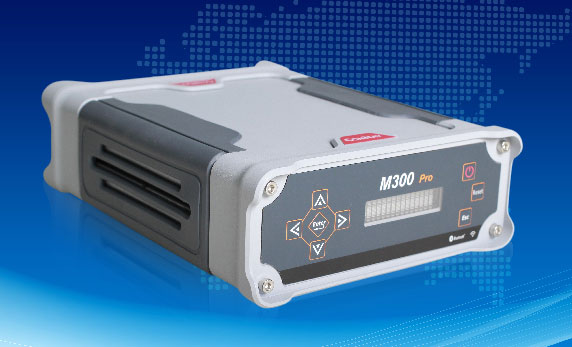
The M300 Pro is a multi-purpose CORS GNSS receiver designed for applications such as positioning infrastructure, active geodetic network, deformation monitoring, machine guidance, harbor construction, land surveying and marine surveying. Designed for reference stations, the M300 Pro tracks GPS, GLONASS and BeiDou (B1, B2, B3), and will track Galileo, QZSS and other coming constellations. Its web server function enables remote control for access, configuration, programming, data download, reboot/restart, firmware update and code registration. It is compatible with many kinds of CORS software, using the standard data format RTCM and the various data transfer protocols such as UDP, TCP and NTRIP. Raw GNSS observation data can be saved in RINEX format and remotely downloaded. Multiple ports can be configured and connected with external sensors such as meteorological sensors, barographs and inclinometers. The PPS output function provides a guarantee for precision timing. It also has the functionality of event mark and external memory.
The Leica Velocity and Displacement Autonomous Solution Engine (VADASE) detects fast movements of man-made and natural structures in real time, running on board Leica reference stations and monitoring receivers. VADASE provides an in-depth look at accurate, high-rate velocity and displacement information of various activities and structures. It gives engineers and researchers complete, precise and reliable monitoring information. VADASE delivers actionable information independent of any GNSS real-time kinematic (RTK) correction service.
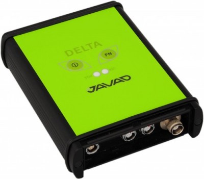
GNSS receiver with onboard memory for data storage
The DELTA-3 receiver has 864 GNSS channels, along with three powerful processors and program memory in a single chip, which uses less power and makes the total system less expensive. The 864 channels allow tracking of all current and future satellite signals. Delta-3 can track and decode the QZSS LEX signal messages. It is a powerful and reliable receiver for high-precision navigation systems, including high-dynamic systems, for machine and traffic control, high-precision surveying, and geodynamics and aerogeophysics applications. Delta-3 can operate as a receiver for post-processing, as a Continuously Operating Reference Station (CORS), or as a portable base station for real-time kinematic (RTK) applications, and as a scientific station collecting information for special studies such as ionosphere monitoring.
A configuration of ArcGIS and a JavaScript application
Photo Survey is designed for local governments to publish street-level photo collections and conduct focused property surveys that can identify blight, damaged structures or construction activity. It leverages location-enabled photos produced by many commercially available cameras and simplifies data processing so street-level photo collections can be gathered on a regular basis. Photo collections can then be combined with relevant survey questions in an ArcGIS Online map, and shared with the Photo Survey application. Once complete, the Photo Survey application can be used by the general public or local government staff to review street-level photos and complete property surveys.
GNSS receiver maker Septentrio has announced the availability of its geographical information systems (GIS) PinPoint-GIS on the ArcGIS Marketplace.
PinPoint-GIS was developed to enable straightforward GIS data collection without the need for expensive additional software linking a GNSS receiver with the Esri ArcGIS Platform
PinPoint-GIS helps ArcGIS users make informed and timely decisions, Septentrio said. It turns GNSS data collected by Septentrio’s receivers such as the Altus NR2, Altus GeoPod and the AsteRx-U into actionable GIS data. Height and other project parameters are available directly in the ArcGIS workflow without any additional steps by the user.
Pinpoint GIS makes ArcGIS easily accessible through existing hardware — consumer commercial and ruggedized device, tablet or even smartphone — regardless of operating system. PinPoint-GIS Web makes ArcGIS available from a standard web browser or from an Android app, downloadable from Google Play.
The Android app works with Esri’s Collector for ArcGIS and provides an accuracy widget which confirms horizontal and vertical accuracy in a highly visible way. This brings the user the immediate security that the captured data meets the required accuracy in both the horizontal and vertical.
“Integrating ArcGIS functionality into PinPoint-GIS empowers ArcGIS Online users,” said Gustavo Lopez, PinPoint-GIS Product Manager. “With the click of a button, a PinPoint-GIS user can turn accurate and reliable GIS data collected from their Septentrio GNSS receiver into actionable data needed for smarter decisions, effective analysis and customized maps all within the easy-to-use ArcGIS.”
Two flights were conducted at 120 meters and 100 meters to gather data to help the Peruvian government protect the site from erosion and wear from tourism. (Photo: Trimble)
High up in the Peruvian Andes Mountains lies Machu Picchu, an Incan citadel built in the 15th century, now a UNESCO World Heritage Site.
In the fall of 2014, Trimble demonstrated its UX5 Unmanned Aircraft System (UAS) — along with the Trimble Business Center and Inpho UASMaster processing software — at the famed archaeological site.
Machu Picchu is under the threat of landslides and erosion — plus the site experiences heavy rains known to wash away roads. It has also seen an increase in tourism over the years.
As a consequence, the preservation of the landmark is a growing concern for the Peruvian government. Data captured by a fixed-wing UAS is expected to help the many organizations that govern and preserve the site to visualize and monitor the location.
Getting to Machu Picchu is a challenge in itself. A 3.5-hour train ride from the city of Cusco takes visitors almost 8,000 feet above sea level. When a Trimble team visited the site, access to Machu Picchu was arranged well in advance by its distribution partner Geosystems and the Peruvian Ministry of Culture.
Orthophoto of the Macchu Pichu site. (Image: Trimble)
The day of the flight, a small area on one of the terraces was cleared of tourists (but not local llamas) for the flight. Two flights were conducted at 120 meters and 100 meters for enhanced data. Along with Trimble and Geosystems representatives, local archaeologists and surveyors from the Ministry of Culture attended the flight, which went off without any challenges.
With the flight complete, Trimble and Geosystems went to work processing the data immediately in Trimble Business Center and Inpho UASMaster. Trimble Business Center allowed the data to be quickly processed into high-quality point clouds and orthophotos while Inpho UASMaster offers feature-rich photogrammetry workflows.
The following day, Trimble and Geosystems presented government officials with orthophotos and a 3D point cloud model.

 A law prohibiting the uprooting of seagrasses coast-wide was passed by the Texas Legislature during the 83rd legislative session and has been in effect since September 2013. Motorboats cause propeller scarring when they drift into shallow waters and tear a trough in the bay bottom.