Topcon Positioning Group and MAVinci GmbH have released the latest version of the Sirius Pro surveying UAS (Unmanned Aerial System) program, designed to be compatible with existing RTK (real-time kinematic) base stations or NTRIP (network transport of RTCM data over IP).
“By connecting an external base station, Sirius Pro will receive the RTCM correction signals and deliver 2-5 centimeter accuracy without using ground control points,” said Eduardo Falcon, executive vice president and general manager for the Topcon GeoPositioning Solutions Group. “When you have mobile Internet on your site, you can achieve the same accuracy even without a local base station using NTRIP.”
Sirius Pro is designed to deliver orthofotos and three-dimensional elevation models with a high absolute accuracy of 2-5 centimeters without using ground control points. “Combining MAVinci‘s precision timing technology with Topcon sub-centimeter grade L1/L2 GPS/GLONASS RTK receivers, this robust system stands up with a clever solution that helps in the realizing of projects in a better and faster way,” said Johanna Claussen, CEO at MAVinci.
For users who do not have an RTK base station, an internal base station add-on for the Sirius Pro is available. “It upgrades the Sirius Pro to its full functionality: Use of an internal or external base station depending on your needs,” Claussen said. “This add-on is available anytime via Internet without changing your hardware.”
Sirius Basic is an entry-level solution for UAS surveying, and delivers orthofotos and 3-D elevation models. The system is designed to offer high-accuracy when using ground control points. “Sirius Basic offers you full flexibility,” said Falcon. “It can be upgraded to Sirius Pro via an Internet update later on — no hardware change is necessary.”
The system will be available at the Intergeo trade show for geodesy in October and thereon. The Topcon and MAVinci UAS was first introduced at Intergeo 2013 for the European market and was recently made available in the North American market.
Septentrio and Altus will be presenting their high-performance RTK systems at ION GNSS+ 2014. Attendees are invited to learn more at:
The Triple-frequency Multi-system RTK Engine for Challenging Environments (Session A1 room 18, Wed. 9/10 @11:48)
Gap Bridging in Precise Point Positioning (Session B6 room 19, Fri. 9/12 @3:20)
High-performance RTK provides accurate positioning
in urban environments or under dense canopies
while suffering high ionosphere activities or
when coping with sparse networks
for maintaining a smooth transition during outages
Plus, there is no baseline impact, even at greater than 40 kilometers. Visit booth 318/320 in the Exhibit Hall to learn more about the technology behind the performance.
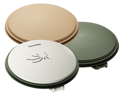
The NovAtel GPS-702-GG-HV high-performance pinwheel antenna comes in three colors. Photo: NovAtel, Inc.
NovAtel, Inc., has introduced the GPS-702-GG-HV to its line of high-performance Pinwheel antennas. Tracking L1/L2 GPS and L1/L2 GLONASS frequencies, customers can use the same antenna for GPS-only or dual constellation applications, reducing equipment costs and need for future redesign, the company said.
With the same form-factor and choke ring performance as the company’s other pinwheel antennas, the GPS-702-GG-HV has been enhanced even further to provide the robustness needed for use under high-vibration conditions.
The phase center of the antenna remains constant as the azimuth and elevation angle of the satellites change. Signal reception is unaffected by the rotation of the antenna or satellite elevation, so placement and installation of the antenna can be completed with ease. With the phase center in the same location for both the L1 and L2 signals and with minimal phase center variation between antennas, this antenna is designed for baselines of any length.
Enclosed in a durable, waterproof housing, the GPS-702-GG-HV comes in three colors: NovAtel standard grey, as well as desert tan and olive drab for military customers. The antenna is available for order beginning September 12.
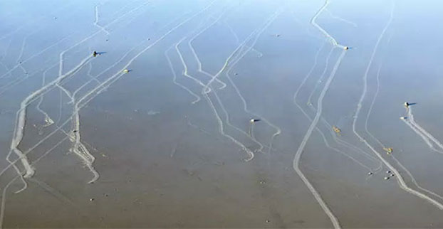
Rarely formed sheets of ice push rocks across a dry lake in Death Valley.
In Racetrack Playa in Death Valley, California, hundreds of rocks — some weighing as much as 700 pounds — seem to have been dragged across the ground, leaving synchronized trails that can stretch for hundreds of meters. Though many phenomena were speculated (hurricane-force winds, dust devils, slick algal films, thick sheets of ice), no one knew what caused the movement.
To solve the mystery, in 2011 a team of researchers led by paleobiologist Richard Norris, Scripps Institution of Oceanography, UC San Diego, began monitoring the rocks remotely. The research team fit 15 similar rocks with custom-built, motion-activated GPS units (the National Park Service disallowed use of native rocks) and installed a high-resolution weather station capable of measuring gusts to one-second intervals. Then — in what Ralph Lorenz of the Applied Physics Laboratory at the Johns Hopkins University suspected would be “the most boring experiment ever” — the researchers waited for something to happen.
In December 2013, Richard Norris and co-author and cousin Jim Norris discovered that the playa was covered with a pond of water three inches deep. Shortly after, the rocks began moving.
“Science sometimes has an element of luck,” Richard Norris said. “We expected to wait five or ten years without anything moving, but only two years into the project, we just happened to be there at the right time to see it happen in person.”
Their observations show that moving the rocks requires a rare combination of events. First, the playa fills with water, which must be deep enough to form floating ice during cold winter nights but shallow enough to expose the rocks. As nighttime temperatures plummet, the pond freezes to form thin sheets of “windowpane” ice, which must be thin enough to move freely but thick enough to maintain strength. On sunny days, the ice begins to melt and break up into large floating panels, which light winds drive across the playa, pushing rocks in front of them and leaving trails in the soft mud below the surface.
“On December 21, 2013, ice breakup happened just around noon, with popping and cracking sounds coming from all over the frozen pond surface,” said Richard Norris. “I said to Jim, ‘This is it!’”
The rocks moved under light winds of about 3-5 meters per second (10 miles per hour) and were driven by ice less than 3-5 millimeters (0.25 inches) thick, a measure too thin to grip large rocks and lift them off the playa, which several papers had proposed as a mechanism to reduce friction. Further, the rocks moved only a few inches per second (2-6 meters per minute), a speed that is almost imperceptible at a distance and without stationary reference points.
“It’s possible that tourists have actually seen this happening without realizing it,” said Jim Norris. “It is really tough to gauge that a rock is in motion if all the rocks around it are also moving.”
Individual rocks remained in motion for anywhere from a few seconds to 16 minutes. In one event, the researchers observed rocks three football fields apart began moving simultaneously and traveled over 60 meters (200 feet) before stopping. Rocks often moved multiple times before reaching their final resting place. The researchers also observed rock-less trails formed by grounding ice panels — features that the Park Service had previously suspected were the result of tourists stealing rocks.
“The last suspected movement was in 2006, and so rocks may move only about one millionth of the time,” Lorenz said. “There is also evidence that the frequency of rock movement, which seems to require cold nights to form ice, may have declined since the 1970s due to climate change.”
The team’s findings were published in the journal PLOS ONE on August 27.
Topcon Positioning Group has released two unmanned aerial systems (UAS) for mapping — the Sirius Pro and Sirius Basic. Both systems are designed to produce the most accurate solutions for the automated mapping of a wide range of sites — regardless of terrain — including construction sites, mines and quarries, and for use in land surveying, power line and pipeline inspection as well as precision agriculture field mapping.
The fixed-wing systems resulted from a partnership with MAVinci GmbH, a UAS development company with which Topcon recently entered into a worldwide distribution agreement.
“The Sirius Pro system is unique to the UAS marketplace. Instead of using traditional ground control points, Topcon combines RTK (real-time kinematic) GNSS solutions with precision timing technology to provide more accurate mapping results when compared to other products,” said Eduardo Falcon, executive vice president and general manager for the Topcon GeoPositioning Solutions Group.
“The system is easy to use and rugged — allowing operators to use a simple hand launch with precise automatic operation from takeoff to landing, and it can be flown safely in nearly all weather conditions,” Falcon said.
The Topcon Sirius Basic is an entry-level system offering many of the advantages of the Sirius Pro with options to upgrade. “The Sirius Basic shares the same hardware components of the Pro model, providing affordability with the same level of sturdiness and ease of operation,” said Falcon. “Additionally, when the need arises for the increased accuracy and productivity of the Pro system, a simple upgrade makes the transition practically effortless.”
Both systems also offer autopilot assisted manual control, automatic flight planning and safety features.
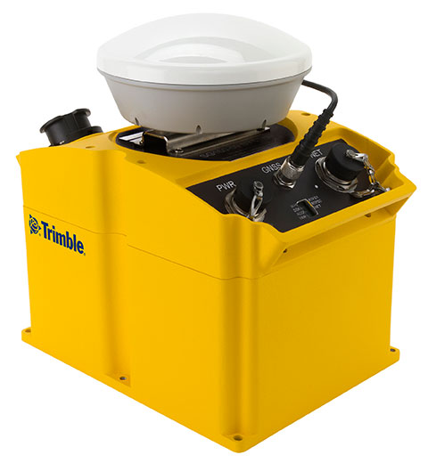
Trimble has introduced an integrated GNSS reference receiver, broadband seismic recorder and a force-balance triaxial accelerometer for infrastructure and precise scientific applications.
The Trimble SG160-09 SeismoGeodetic system provides real-time GNSS positioning and seismic data for earthquake early warning and volcano monitoring as well as infrastructure monitoring for buildings, bridges, dams, as well as other natural and manmade structures.
The Trimble SG160-09 SeismoGeodetic system combines the innovation, reliability and data integrity of both the Trimble and REF TEK brands into a single instrument, Trimble said. The system integrates seismic recording with GNSS geodetic measurement in a single compact, ruggedized package. It includes a low-power, 220-channel GNSS receiver powered by the latest Trimble-precise Maxwell 6 technology and supports tracking of both GPS and GLONASS signals plus the Galileo E1 frequency.
The system includes both the SG160-09 and utilization of Trimble’s CenterPoint RTX correction service, which provides on-board GNSS point positioning. Based on Trimble RTX technology, the service utilizes satellite clock and orbit information delivered over cellular networks or Internet Protocol (IP), allowing cm-level position displacement tracking in real-time anywhere in the world. The SG160-09 system will be available for purchase without the RTX correction service for those applications using real-time kinematic (RTK) positioning.
The seismic recording sensor includes an ANSS Class A, low-noise, force-balance triaxial accelerometer with the latest, low-power, 24-bit A/D converter, which produces high-resolution seismic data. The internally built accelerometer has +/- 4g full scale output, large linear range, high resolution and sensitivity, which makes it ideal for both portable and permanent deployment. The SG160-09 processor acquires and packetizes both seismic and geodetic data and transmits it to system operators using an advanced, error-correction protocol with back-fill capability providing data integrity between the field and the processing center.
The SG160-09 system is ideal for earthquake early warning studies and other hazard mitigation applications, such as volcano monitoring, building, bridge and dam monitoring systems. The SG160-09 system features a variable size industrial grade USB drive to support real-time telemetry data transmission. In the event of a telemetry link outage, the data is stored on the USB drive and can be re-transmitted to the centralized processing station as soon as the communication link comes back up, allowing no data loss during the system operation.
The Trimble SG160-09 system is optimized for field use with instrument mounted or externally mounted GNSS antenna configurations. The lightweight yet rugged SG160-09 consumes very little power and can be used for projects with remote connectivity and in extreme weather conditions. Because the SG160-09 combines both GNSS and strong motion in a single instrument, site installation time is reduced, data communications flow through a single pathway, and station power infrastructure is streamlined, making the SG160-09 a cost competitive solution compared to other systems on the market today. It has an IP67 rating, which means it is sealed against dust and can be submerged in water up to a meter for approximately 30 minutes. The SG160-09 also meets MIL-STD 810F standard for drops, vibration and temperature extremes.
“The SG160-09 is another example of Trimble’s on-going focus in GNSS and seismic technology for the scientific and engineering communities,” said Ulrich Vollath, general manager for Trimble’s Infrastructure Division. “Trimble has developed a combined state-of-the-art GNSS receiver with a high-dynamic range, low-noise accelerometer that provides dynamic monitoring with the flexibility required for today and tomorrow’s challenges.”
The Trimble SG160-09 SeismoGeodetic system is expected to be available in the fourth quarter of 2014.
JAVAD GNSS is introducing its new unmanned aerial vehicle with the dramatic flourish of a video showing the UAV in flight, accompanied by the “Also Sprach Zarathustra” theme from 2001: A Space Odyssey.
The TRIUMPH-F1 unmanned aerial vehicle is based on the JAVAD GNSS TRIUMPH-1. TRIUMPH-1 is the company’s field-tested high-precision geodetic GNSS receiver with 864 channels to track all current and future GNSS signals.
When used on the ground, the TRIUMPH-F1 can function as a TRIUMPH-1 base or rover. The four motor arms (for eight motors) are detachable. There are four screw inserts in the bottom to attach the TRIUMPH-F1 to a pole mount for field use.
The Carlson BRx5 GNSS receiver, an integrated all-in-one pole-top GNSS receiver, has just been released by Carlson Software, Inc. Each BRx5 contains a multi-constellation, multi-band 270-channel GNSS receiver, internal GSM cell modem, UHF radio, dual hot-swappable batteries and internal level sensors. Designed for survey and GIS professionals, the Carlson BRx5 delivers both affordability and the highest positional accuracy, the company said.
“Carlson’s exclusive LDL (live digital level) feature in SurvCE 4.0 uses the BRx5’s internal level sensors to provide electronic leveling for better x,y accuracy as you work,” said Bruce Carlson, president of Carlson Software. “In addition, it holds fix under canopy better than most GPS systems currently on the market.”
Manufactured to Carlson’s exacting specifications by Hemisphere GNSS, the BRx5 receivers can each be configured as base, rover, or network rover. They come with dual Bluetooth ports, allowing users to connect both data collector and a cell phone, and they each come with a fully integrated multi-constellation dual frequency GNSS receiver with UHF radio and GSM cell modem.
SurvCE 4.0 allows high positional accuracy with the BRx5′s integrated level sensors.
Designed for use by surveyors, contractors, builders, engineers and many others, the BRx5 can be purchased as either a Rover or as a Base/Rover package. The Base/Rover package includes two BRx5 GNSS receivers, one hard-sided carrying case, four BRx5 batteries with two chargers, one GPS tribach and one tribach adapter, and two Carlson GPS receiver poles.
With its dual hot-swap batteries, there’s no need to stop work to recharge or replace battery packs. In addition, the BRx5 is OmniSTAR-capable with submeter differential correction available worldwide.
The Carlson BRx5 GNSS receiver is designed to work seamlessly with most data collectors including Carlson’s rugged and popular data collectors: the Carlson Surveyor+, the Carlson MINI2, and the Carlson Supervisor.
The European-focused imaGIne conference will provide attendees with an opportunity learn what is going on in the geospatial sector and to network with important decision-makers. EUROGI’s “imaGIne: Opportunities Everywhere” Conference will be held October 8-9 in Berlin, Germany.
The imaGIneconference will take place at the same venue and at the same time as the InterGeo trade fair.
A key aim of the conference is to showcase the best that Europe has to offer in the geospatial field, thus the conference subtitle “Geographic Information Expertise: Made in Europe.” The aim has guided EUROGI and its member associations in the selection of themes and speakers, organizers said.
Plenary Sessions and Keynotes
During the plenary sessions, presentations will be given by top European and global experts.
Roberto Viola, deputy director, Directorate General CONNECT, European Commission, will provide an outline of the European Union’s Digital Agenda Europe, with particular emphasis on geospatial aspects.
Detlef Dauke, director general, German Federal Ministry for Economic Affairs and Energy will speak on behalf of the German vice-chancellor, who is the patron for the conference.
Two speakers will provide a view of the state of the European geospatial industry from a global perspective, highlighting its strengths, weaknesses, opportunities and threats. Other issues which will be covered in the plenaries include the Internet of Things (billions of interlinked sensors across Europe), Linked Data (joining up data which was otherwise unconnected) and Big Data (massive amounts of data from diverse sources and across many fields).
In addition to the plenary sessions, there will be 15 parallel sessions of 90 minutes each, each of which has a specific thematic focus. The themes include Job Creation and Economic Growth, Energy, Environment, Demography, Smart Cities, Copernicus (Europe’s Earth Observation initiative), Open Data, Big Data, and Insurance. The sessions will not only provide interesting insights, but will also feature panel sessions with discussions of pertinent issues, as well as opportunities for audience engagement.
The European Commission’s Joint Research Centre will provide an opportunity to discuss the European Union Location Framework, a set of policies and measures which aim to facilitate the integration of geospatial information into e-government services and to increase alignment in and between existing and future EU policies.
InterGeo Fair. InterGeo is the world’s leading trade fair for geodesy, geoinformation and land management. With over half a million event website users, over 16 000 direct visitors each year from 92 countries and more than 500 exhibitors, it is one of the key platforms for business dialogue in the geospatial information sphere.
Registration for EUROGI’s imaGIneconference will automatically entitle delegates to visit the fair.
More information about the conference can be found at www.imagine2014.eu. The website also provides the opportunity to register. An early-bird discount rate will be available until August 31.
The Geospatial Sector — Huge and Growing Fast
Geospatial information, also often referred to as geographic information, is any information that has a location/position “tag.” The tags can take many forms, including for example, postal codes, street addresses, words that have a location/place reference (such as Barcelona, the Rhine, Slovenia, etc.), north/south coordinates, and more. Organizing and managing tags enables vast amounts of otherwise disparate information to be integrated and new and innovative insights and services to be provided.
According to a report published last year by Oxera, a leading UK economic research firm that was commissioned by Google, at $150-270 billion annually the geospatial sector globally was one third the size of the global airline industry. (See “What is the Impact of Geospatial Services?”)
The report states, “Geo services are making an important contribution to the global economy and to future productivity. The efficiency gains they create are helping to facilitate future economic activity and generate additional consumer welfare.”
Everyone is aware of the airline industry, but very few are aware of the geospatial industry, an industry that to a very large extent operates out of direct public view, but that produces products and services that impact on billions of people worldwide on a daily basis. The insurance, automotive, telecommunications, navigation, marine, agriculture, energy, utilities, tourism, and recreation and media industries are just some of sectors that rely heavily on geospatial products and services.
Apart from the enormous size of the sector, another key point highlighted in the Google-sponsored research report is that the sector is growing globally at about 30 percent annually. With overall global economic growth taking place in the lower single-digit range, growth of this nature can truly be described as explosive, conference organizers said.
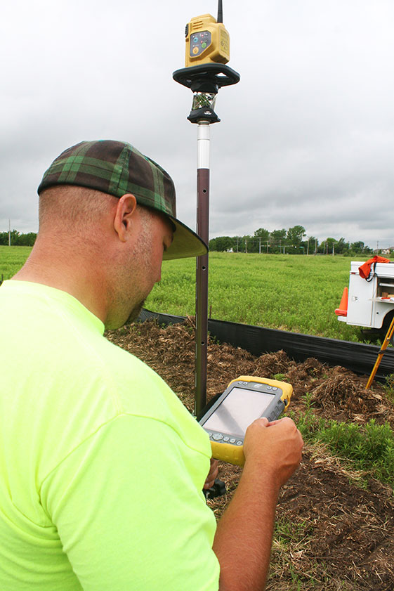
Topcon Tesla handheld controller combines the advantages of a PC tablet with the ruggedness of a fully equipped survey device.
An Oklahoma Survey Firm Is Increasing Productivity with Cloud-Based Solutions
By Larry Trojak
Until recently, the flow of real-time information and job-critical data between the office and personnel in the field for survey and construction has not kept pace with advances in onsite GNSS equipment. But enterprise software suites are closing the gap, producing across-the-board efficiencies, cost reductions, and an ability to bid more competitively.
Sisemore Weisz & Associates (SW&A) of Tulsa, Oklahoma, is an engineering specialist in site design and land planning, and has survey experience with ALTA/ACSM work, high-end civil construction, structural layout, and large survey control networks. Topcon’s cloud-based software suite Magnet gives SW&A the ability to have immediate access to the plans, data, and site information needed to respond to and complete the job.
“Providing the ability for any crew to immediately access their data from anywhere via a Tesla field tablet is invaluable. It’s literally changed the way we do business,” said SW&A chief of parties Shawn Collins.
Collins’ ultimate goal was to establish a platform for data collection, sharing, and transfer that best utilized today’s technology, including Internet access and the ability to email and text message crews in real-time.
His first instinct was that a tablet such as an iPad might be the answer, but iPads weren’t suitable for surveying Instead, they chose Topcon’s newly introduced Magnet Enterprise package along with a pair of Tesla controllers. Finding it the right solution, after a few weeks they bought more Teslas. “It was just the solution we needed,” Collins said.
Magnet Suite
Comprised of three individual software components — Field, Tools, and Office — as well as the Enterprise cloud environment itself, the Magnet suite of products is designed to bring real-time, cloud-based efficiency to any survey or construction operation, according to Jason Hallett, Topcon’s senior product manager for software applications.
“Magnet considers everything from data collection, to CAD, to data manipulation and reporting, to data exchange, to cloud-based project management in an enterprise environment,” Hallett said.
Components of Magnet:
Field. Connects field users to the cloud, and enables real-time communication, as well as cloud storage and data exchange. A powerful field software for topo, staking, roads, and calculations is included.
Tools. Allows the processing and exchange of data between the enterprise cloud and popular desktop applications, such as Autodesk Civil 3D.
Office. Exchanges design files, survey jobs, and surfaces through the enterprise cloud for simple project revisions and real-time survey data from the field.
Dillon Dossey is a one-man crew with Magnet and the cloud.
In the year since they began using Magnet, Collins said that the system has become an integral part of the way SW&A does business. “It can be something as simple as getting a crew working faster than we ever could in the past,” Collins said. “For example, say we are set to begin a large highway project several hours from the office, but we are wrestling with plans or have calculations that still need fine-tuning on one part of the job. In the past, the whole project would have been held up until those issues were resolved. Now, we can send a crew out with what we already have and, when that missing data is completed, upload it to the cloud for them to access when they need it. As a result, production is on track, deadlines are met, and the customer is pleased.”
Re-routing crews — a time-consuming effort in the past —is now a simple process. “If a crew wraps up a project and needs to be re-routed from their original follow-up job, they now can simply check email or chats on their Tesla and see what’s changed. All of their pertinent information is going to be in the chat and in the cloud — all the directives are there, all the paperwork, everything they need to make a fast, seamless transition to the next job without having to come back to the office. Just minimizing those trips back here has shown us a nice 14 percent reduction in fuel costs since going forward with Magnet. And taking that 14 percent off of a bid allows us to be that much more competitive.”
As chief of parties, one of Collins’ primary roles is quality control on projects, and Magnet has helped. “I can show up to a site to see how a crew is doing, have them upload data to the cloud, and confirm their progress. As a result, managing the parties, managing the control, managing the job flow is so much better. And, contrary to what one might think, the fact that the crews know they are being checked has not had any downside at all. They know we are all on the same team and appreciate that this technology is helping make us more competitive — which ultimately benefits everyone.”
Collins has witnessed dramatic changes in his 30 years of surveying, but sees Magnet as a game-changer for data management and flow, the exchange of information, and bidding on jobs which, thanks to Magnet Enterprise’s cloud-based environment, has become a streamlined, efficient process.
“It is now possible to easily cross-reference jobs to help in the bidding process,” he said. “We can go into our cloud and see if we did a similar job before, and, if so, view the work order, view the billing files, see how much that job actually cost, see what we bid on it, see if we were profitable, see how we did for time management, and so on. In the past that would have been a painstaking, time-consuming process. But with that all data readily at hand, it is easy to put together an informed, competitive bid and get it out to the client in no time.”
One area that Collins hopes to pursue further is deeper client involvement. “We recently added 5 GB of capacity to our cloud storage, and that should help us move forward with that push. Making it possible for the client to look at the project as it exists in real-time, to be able to review and red-line items or discuss issues, and do so without a trip to our office will be a real plus.”
One-Man Crew
A visit to a local development called Yorktown finds a single rod man, Dillon Dossey, at work, a typical scenario for SW&A. “This is a 120-lot development, and Dillon has been the sole SW&A person on this job since the outset, surveying and staking to rough in roads for the developer, and he will be here until our portion wraps up,” Collins said.
With Topcon’s PS-103 robotic total station (SW&A’s latest purchase), his Tesla, and Magnet — which is also built into the total station — Dossey can operate as a one-man crew with confidence, Collins said. “If Dillon gets into a situation where he suspects something is wrong or he needs help deciding something, he doesn’t have to break down his equipment and drive all the way back to town; he has everything he needs right there with him. He has the data, he can chat with me, with the office, and we can send data right back to him.”
Dossey offered his take on Magnet’s impact on his role at SW&A. “We are working toward eventually eliminating the need for us to go back to the office at all,” he said. “If we have to, we can come in to get gear in the morning, but that’s about it. However, right now, if I am halfway through a job and Shawn contacts me to head to another one, he just sends me all the info I need and I’m on my way. It is very cool. The amount of data that we can exchange back and forth through the cloud is just startling.”
Trimble has introduced the DPS900 Piling System, a dedicated land-based 3D machine control system for a variety of piling machine makes and models. The accuracy of the system allows piling contractors to increase operational efficiency and reduce costs for building structural foundations, retaining walls, coffer dams, and solar or wind farm installations.
“The DPS900 Piling System can transform the way piling contractors work,” said Alan Sharp, business area director for Trimble Heavy Civil Construction. “Without DPS900, the process is manual and often error prone. With the DPS900 system, contractors can take advantage of accurate positioning and automated reporting to ensure machines are being utilized efficiently.”
The DPS900 Piling System reduces surveying costs associated with staking and as-built checks. In addition, the system can increase on-site safety by reducing the number of people around machines, pilings and foundations. Accurate positioning in DPS900 can ensure navigation time between piles is reduced, resulting in increased piling time to maximize production and revenue per day.
Built-in, automated quality assurance and quality control reporting includes capture of start and end positions, time and elevation, as well as actual embedment depth, blow count reporting, and inclination and orientation control. In addition, unique system logins allow managers to filter reports by operator for better accountability, production optimization and forecasting.
Business Center–HCE office software by Trimble is used to create pile plans in the office, and allows for integration with data prep, estimating and reporting functions. Piling machines can be connected to the office using Trimble Connected Site solutions for wireless data transfer and GNSS corrections. In addition, machines can be tracked and monitored using VisionLink for location, hours and utilization information.
The new Trimble DPS900 Piling System is available now in Australia, Europe, North America, Chile and South Africa through Trimble’s SITECH Technology Dealer Channel.
Registration is open for Trimble’s International User Conference, Trimble Dimensions, being held November 3-5 at the Mirage and the Treasure Island Hotels in Las Vegas. The conference addresses innovations in agriculture, construction, civil infrastructure, engineering, government, mapping, natural resources, surveying, telecommunications, transportation, logistics and utilities.
Trimble Dimensions provides insight into how information technology can transform the way professionals work by using integrated workflows to increase productivity, the company said. Participants can hear how industry colleagues use Trimble’s end-to-end technology to transform data into intelligent, usable information. Attendees will see first-hand how new tools, processes and ideas can help make a positive impact on their business.
Throughout the conference, attendees will have a variety of opportunities to network with key industry players, nurture existing business relationships, build partnerships, and discover how to overcome challenges in today’s competitive business environment.
Highlights include more than 400 educational sessions, including both on-site and off-site immersive training, more than 30 specialized tracks to advance career objectives with many sessions qualifying for Professional Development Hour (PDH) hours, and on-site product demonstrations.