Trimble has introduced additions to its GNSS portfolio — the Trimble NetR9 Geospatial receiver; the Trimble Geo7X with Trimble Access field software onboard; and enhanced Trimble xFill functionality that provides continuous RTK level accuracy when paired with a Trimble CenterPoint RTX subscription. The new additions offer surveyors more flexibility in the field to meet a variety of work requirements.
The announcement was made today at InterGeo 2014, the world’s largest conference on geodesy, geoinformatics and land management.
The Trimble NetR9 Geospatial GNSS Receiver. Photo: Trimble
Trimble NetR9 Geospatial GNSS Receiver. The Trimble NetR9 Geospatial has been configured as a comprehensive modular GNSS receiver for the professional survey market. The lightweight form factor of the NetR9 comes fully loaded with performance enhancements including: Trimble HD-GNSS technology, Trimble 360 technology, Trimble CenterPoint RTX correction service support and Trimble xFill technology. The combination of these capabilities provide a powerful solution that delivers accurate positioning and support for all existing and currently planned GNSS constellations, and continuous RTK-level precision during interruptions of the primary correction source, Trimble said.
Serving as either a rover or mobile base station, the NetR9 Geospatial offers the flexibility to choose a GNSS antenna and radio solution that matches the surveyor’s specific workflow needs. “Trimble’s GNSS solutions are designed to meet the unique requirements of surveyors,” said Elmar Lenz, business area director of GNSS Solutions for Trimble’s Geospatial GNSS Division. “These solutions provide professionals in the survey and engineering industry with flexible tools to stay productive and competitive, delivering the appropriate solution for any survey project that’s being completed, no matter where our customers work and survey.”
Trimble Geo 7X with Trimble Access. Designed for surveyors facing a variety of workflow requirements to accomplish both high-accuracy surveying and handheld point measurement, the Geo7X is now available with Trimble Access field software onboard. With Trimble Access onboard the Geo7X, surveyors benefit from a familiar, easy-to-use software interface that provides common survey workflows directly on their GNSS handheld, resulting in increased data collection efficiency.
The Geo7X is a dedicated network rover that can be used on a survey rod with an external antenna for survey-grade accuracy. If the surveyor prefers the convenience of a highly mobile handheld solution, they can snap if off the rod and switch to the internal antenna. In this mode, they also have easier access to other features such as the integrated camera for collecting attribute data.
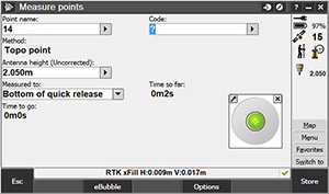
Trimble xFill in use. Photo: Trimble
Expanded Trimble xFill Functionality. Expanded xFill functionality, available in the Trimble R10 GNSS receiver and NetR9 Geospatial receiver, allows surveyors to continue collecting data with centimeter accuracy indefinitely throughout their workday when the connection to the base station or VRS network is lost. The expanded xFill functionality is enabled via a CenterPoint RTX subscription.
Without a Trimble CenterPoint RTX subscription, xFill maintains RTK level accuracy for up to five minutes during interruptions in the primary terrestrial correction stream. This basic xFill functionality is included with the Timble R10 GNSS system and is now included with the NetR9 Geospatial GNSS receiver.
“With expanded accuracy levels and seamless RTK/RTX transition, the Trimble R10 continues to offer unprecedented capability to the survey professional,” said Lenz. “Connectivity problems are traditionally one of the biggest GNSS-related challenges a surveyor will face while in the field and expanded Trimble xFill functionality significantly helps solve that problem, saving time and money.”
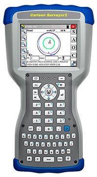
The Carlson Surveyor2, the newest model of Carlson Software’s Carlson Surveyor line of data collectors, was launched at the InterGeo Trade Show in Berlin this week.
The handheld surveyor is on display at Carlson’s Stand 1.037, Hall 1.1, at InterGeo.
Fast, durable and more powerful, the Carlson Surveyor2 is ruggedized, with an IP68 water and dust-resistant ingress rating. Still weighing two pounds, the Carlson Surveyor2 offers increased program memory (now 512MB) and increased non-volatile data storage (now 8 gigabytes), and a 1.0-GHz processor to provide the speed surveyors need in the field. It comes equipped with significantly increased Bluetooth range, up to 1500 feet when paired with a class I device.
The Surveyor2’s QWERTY keyboard eases data entry and is designed to be workable even for those with large hands or wearing gloves. The backlit keys and larger, brighter display screen allow users to work effectively in all lighting conditions.
“Not only did the Surveyor2 retain the durability of its predecessor, but its higher-resolution, easier-to-read display screen also comes with scratch-resistant glass,” said Bruce Carlson, president and founder of Carlson Software. “An added convenience is its enhanced battery life — up to 20 hours.”
The Surveyor2 has kept its easy-to-grip design, being thinner front to back than other data collectors when resting on a table top. The computer runs on Windows Mobile 6.5.3 and Carlson SurvCE 4.0 can be included. SurvCE is the powerful data collection software used around the world.
The Surveyor2 is designed for surveying, stake out, construction layout and GIS mapping. The easy-to-use, tab-based menu and advanced graphics in Carlson SurvCE 4.0 enhance the Carlson Surveyor2’s usability. Options include an integrated GSM cell modem for real-time connectivity, an integrated 5 MP camera with LED illuminator that doubles as flashlight, and a mapping-grade GNSS receiver.
Hemisphere GNSS has announced two low profile, multipurpose antennas that it says will exceed expectations in all GNSS applications. With unique filtering patterns and precise attention paid to mitigation of multipath and interference, the A25 and A45 antennas complement all GNSS products, from L1 GPS to multi-frequency, multi-constellation.
The A25 and A45 have been designed to support millimeter accuracy for land and marine applications. Both antennas support present and future GNSS signals, including GPS, GLONASS, BeiDou, QZSS, and Galileo. The A25 supports the previously mentioned signals at a single-frequency level, while the A45 supports these signals at a multi-frequency level.
“We’ve designed these antennas to excel in challenging environments such as near buildings or under foliage,” said Lyle Geck, senior manager of product marketing at Hemisphere GNSS. “They have superior multipath mitigation, stable phase centers and strong SNR’s, even at low elevations.”
The ruggedized housing used by both antennas is made of an aluminum base that has been pretreated for the marine environment and will withstand salt, fog, and spray. The antennas pass the two-meter pole drop test.
The A25 is a multi-GNSS precision antenna, designed for a variety of applications including GIS, single-frequency RTK positioning and navigation, and precision guidance. The A45 is a survey-grade, multi-GNSS precision antenna for a variety of applications including surveying, RTK positioning and navigation, precision guidance, and machine control.
GPS World staff will be reporting from InterGeo October 7-9. The massive trade show, held this year in Berlin, is considered the world’s leading conference trade fair for geodesy, geoinformation and land management. With more than 16,000 visitors from 80 countries, it is one of the key platforms for industry dialogue.
Staff members attending include GPS World Editor and Publisher Alan Cameron, Survey/GIS Editor Eric Gakstatter, and Digital Editor Joelle Harms. All three are accepting meeting invitations for companies interested in discussing their products and services. Contact [email protected].
VIDEO PLAYLIST
PHOTOS
Photo: GPS World
Topcon demonstrates its LN-100W, an update to its line of 3D positioning systems designed for one-operator layout. Photo: GPS World
German-based Multirotor by servicedrone is a UAV for professional 3D orthography. Photo: GPS World
Attendees listen to a presentation on the show floor at InterGeo held October 7-9 in Berlin. Photo: GPS World
Attendees watch UAV demonstrations at the conference’s flight zone. Photo: GPS World
Attendees take a look at one of the many UAVs seen at InterGeo 2014 in Berlin. Photo: GPS World
German-based Moskito GIS GmbH displayed a model from its 5 Power GIS. Photo: GPS World
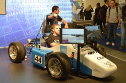
BRS Motorsport Formula Students from Bonn-Rhein-Sieg University of Applied Sciences showcase their simulator, sponsored by CPA ReDev. Photo: GPS World
Riegl debuted and demonstrated its RiCOPTER UAV with LiDAR Integration. Photo: GPS World
At dusk the night before the conference the moon overlooks the Brandenburg Gate, an 18th century arch in Berlin and one of its most well-known landmarks. Photo: GPS World
Summary: UAVs (unmanned aerial vehicles) are taking over the surveying industry, thanks to their ever-improving sensors and the fact that they are getting lighter and can therefore remain in the air for longer. They complete surveying and inspection tasks that would otherwise be difficult to tackle, and do so with impressive cost-efficiency. UAV trends and technology will be among the focal points at the InterGeo conference in Berlin in early October.
Our correspondents will return with a fresh report, moderated by GPS World Editor and Publisher Alan Cameron and Survey Scene Editor Eric Gakstatter.
Data Mapper, an enterprise aerial data software by PrecisionHawk, will expand its cloud-based platform to process data collected by a wider network of unmanned aerial vehicle (UAV) providers. The application provides the ability to upload, store, process and share aerial imagery and is equipped for detailed, automated analysis.
Previously the company was known under the name PrecisionMapper, and the software could only be used when collecting aerial data with the PrecisionHawk UAV platform Lancaster HawkEye Mark III.
“As we began to collect data with the PrecisionHawk UAV across data intensive industries, we discovered a clear gap in the market for an end-to-end, enterprise level solution,”said Christopher Dean, CEO of Data Mapper. “The creation of Data Mapper was a way for us to ensure that what matters most to our customers, the ability to transform aerial data into actionable information, was available quickly and cost effectively.”
The platform is accessible on numerous devices and allows a user to see data in real time, long before a processed orthomosaic is available. Post processing is automated, and processed data can be shared across devices or analyzed using sophisticated algorithms. Data Mapper geospatial experts have been working closely with university partners across the nation to determine the most pressing algorithms for the agriculture industry such as plant height, weed detection, plant counting and canopy cover.
Because of its early integration with the PrecisionHawk platform, Data Mapper has a strong client base that includes Fortune 500 companies, global agriculture companies, education and research institutions and individual agricultural producers, PrecisionHawk said.
As the UAV industry quickly expands, data intensive markets such as agriculture can be equipped with a streamlined, information delivery structure that fits into an everyday workflow. Engineers have bootstrapped the technology to ensure seamless integration with workflows that rely heavily on accurate information to support business practices, PrecisionHawk said.
“UAVs are an extremely effective and efficient means for collecting data, but the value of this technology goes far beyond an aircraft,” said Andrew Slater, VP of software development for Data Mapper. “Data Mapper is a tool designed to close the gap between a service that UAVs provide and the value of that service, which isinformation delivery to the right person at the right time.”
The company has worked with data sets across a variety of industries including agriculture, oil and gas, emergency response, forestry and insurance, and will continue to extend its analysis capabilities to different markets. Data Mapper will significantly grow its employee base, hiring geospatial analysts, software engineers and embedded software engineers to work towards a generalized ingestion method for all UAV data in 2015.
Soil Instruments Limited has partnered with Juniper Systems Limited to provide a geotechnical monitoring system using rugged computers and geotechnical engineering instrumentation to improve field activities in the structural and earthworks industry.
Soil Instruments’ Digital Bluetooth Inclinometer Systems are now exclusively using Juniper Systems’ Archer 2 rugged computer, which provides superior readings and data capture, Soil Instruments said. Soil Instruments’ inclinometers are specially designed instruments that provide high accuracy and resolution measurement for the monitoring of structural and earth deformations, movements or settlement.
“The rugged Archer 2 handheld computer pairs beautifully with Soil Instruments’ Digital Inclinometers, providing more accurate readings and data capture than could ever be achieved previously in this industry,” said Simon Bowe, general manager of Juniper Systems Limited.
Juniper Systems’ Archer 2 rugged computer is connected to the inclinometer system via Bluetooth wireless technology. Within the borehole an angular reading is produced by the engineer via the Read button on the Archer 2 screen, which triggers the inclinometer sensors to take the reading.
Those readings are then instantly transmitted via the Bluetooth connection to the Archer 2, captured on-screen and saved in the Archer 2’s database, to be reviewed for accuracy or other needed data measurements. Long days of field work remain productive because of the 512MB of RAM and 8GB of flash storage in the Archer 2.
Data can also be transmitted back to base quickly and accurately via the 3.75G modem in the Archer 2, an action which many other inclinometers cannot complete. At the end of the day, data can be downloaded or transmitted for subsequent comparison against all previous borehole runs, allowing analysis of lateral ground movements over time.
“Soil Instruments has found the perfect field computer to match with our Digital Inclinometer Systems”, said Mike Ziolek, sales and marketing director for Soil Instruments. “The Archer 2 really gives our customers an edge by providing field readings more quickly and clearly than any other inclinometer system.”
The physical features of the Archer 2 and the Inclinometer Systems are highly compatible. The Archer 2’s IllumiView high-visibility display is extra large, incredibly bright, and overpowers glaring sunlight. The backlit LCD easily adjusts to either portrait or landscape orientation, and is glove-friendly and extremely scratch-resistant.
The Archer 2 has ultra-rugged construction with IP68 protection against water and dust, and is shockproof against multiple drops. The intelligent Li-ion battery can operate up to 20 hours on one charge and is hot-swappable in the field. The high-sensitivity GPS/GLONASS/SBAS receiver is highly useful for field work.
The ruggedness of the Archer 2 compliments the secure connections on Soil Instruments’ Inclinometer Systems. The inclinometer probes are mounted to a cable using an advanced waterproof moulding compound, which eliminates field connectors. This means that no on-site connectors get broken or contaminated while working in the field.
Juniper Systems Limited will be demonstrating its superior, rugged handheld computers at InterGeo at Messe Berlin, Germany, October 7-9, in Hall 2.1 on Stand A2.039.
Figure 1. Mammograms in last two years; percent of respondents, by counties.
Trends Discerned in the National Cancer Institute’s Geospatial Databases Carry the Fight Forward
Location matters in cancer, as in many other things. The National Cancer Institute (NCI) recognized this fact more than 40 years ago, and its researchers have been investigating striking geographic differences in many cancers ever since. Most studies have found that these differences were due to lifestyle differences, such as levels of smoking and diet, although research into possible environmental causes are hampered by a lack of exposure data during the relevant period, 20–30 years prior to diagnosis.
Geospatial tools serve NCI in a variety of applications, including:
the identification and display of the geographic patterns of cancer incidence and mortality rates in the U.S. and their change over time,
the creation of complex databases for the study of cancer screening, diagnosis, and survival at the community level,
environmental exposure assessment through satellite imagery,
spatial statistical models to estimate cancer incidence, prevalence, and survival for every U.S. state,
communication of local cancer information to the public and public health professionals through interactive web-based tools,
the identification of health disparities at the local level through the comparison of cancer outcomes across demographic subgroups, and
development of new methods of displaying geospatial data for clear communication to the public and for examination of complex multivariate data by researchers.
Division of Cancer Control and Population Sciences
The Epidemiology and Genomics Research Program (EGRP) and the Surveillance Research Program (SRP) support grant research to use GIS in cancer research and the development of methodologies to accomplish this research. EGRP also funded the development and maintenance of a geographic information system for breast-cancer studies on Long Island (LI GIS). The LI GIS is available to researchers and can be used to study other types of cancer and conditions as well.
Surveillance Research Program
The Statistical Methodology and Applications Branch (SMAB) contributes to GIS research by developing statistical methods for the analysis, display, and web-based communication of geo-referenced cancer data.
The Surveillance Systems Branch (SSB) oversees the Surveillance, Epidemiology, and End Results (SEER) program, an integrated, comprehensive, multiple population-based reporting system of cancer registries covering 26% of the U.S. population. Cancer incidence information is provided at the state, county, and census-tract level. Investigators in SEER’s Rapid Response Surveillance Studies (RRSS) are exploring and applying GIS technology in several areas.
Division of Cancer Epidemiology and Genetics
The Epidemiology and Biostatistics Program (EBP) has a long history of publishing the NCI cancer atlases.
The Occupational and Environmental Epidemiology Branch (OEEB) has an active research program in using satellite imagery to estimate the potential exposure to cancer-causing environmental agents by individuals living in agricultural areas.
As to the finer granularity customarily seen in GIS databases by professionals using them in mapping, natural resource and asset management, utilities, and other sectors, researcher Linda Pickle of Pennsyslvania State University and StatNet Consulting comments:
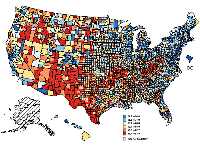
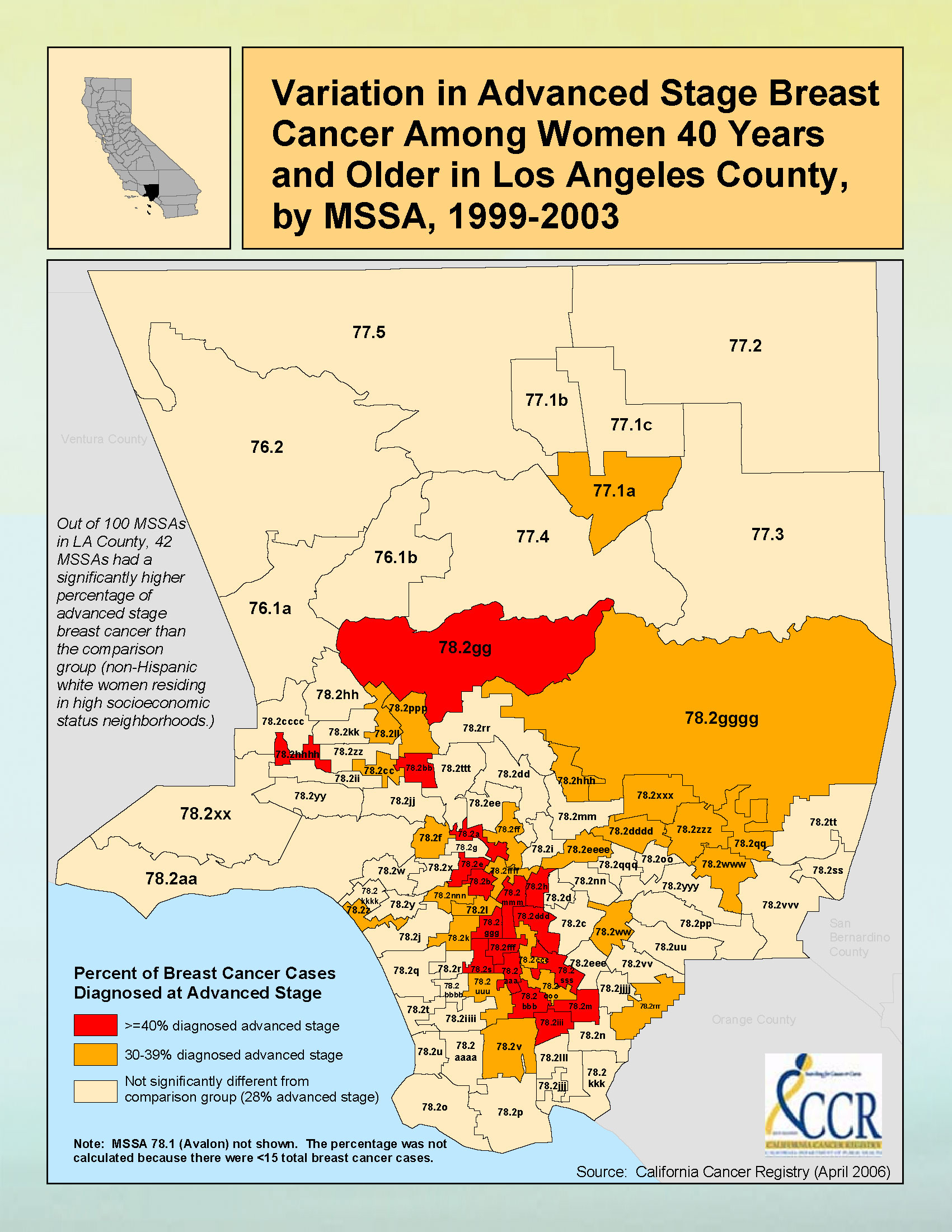
“The SEER program at NCI does get the census-tract identification from the registries, but you have to get permission to use it. Mortality is only reported to NCHS at the county level. Therefore, all nationwide maps of cancer rates (incidence or mortality) must be at the geographic level available for all states, that is, county. Each state has the option to present its own data at smaller levels.
“Figure 2 gives an example of sub-county maps published by California Cancer registries. California is densely populated in many counties, and so the state has defined aggregations of census tracts for their maps. Some of California is in the SEER program; other parts have registries funded by the Centers for Disease Control (CDC).”
Figure 2. Breast cancer data for Los Angeles County.
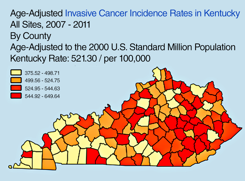
“Another state example: the Kentucky SEER registry has developed a useful online tool to explore Kentucky cancer patterns,” Pickle said. “See Figure 3. This design has been used by CDC for an online U.S. cancer atlas and by other states.”
Figure 3. Cancer incidence rates in Kentucky.
FURTHER READING
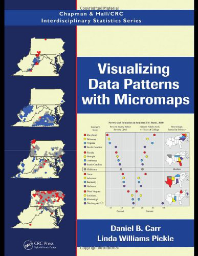
Visualizing Data Patterns with Micromaps By Daniel B. Carr and Lindia Williams Pickle
Cancer surveillance — an assessment of the number and type of cancer cases that occur in an area and in a specified population — provides critically important information needed for determining geographic variations in cancer rates and for planning cancer control intervention programs.
By Li Zhu, Linda W. Pickle, Zhaohui Zou, and James Cucinelli
This article is about projecting from the data that were available from surveillance/data-collection efforts to get estimates of the number of new cancer cases that would occur in the upcoming calendar year. That is, we used data from up to four years previous (because of the time it takes to find cases, process data, and so on) to get a current estimate of the number of cases.
We developed the statistical model to do this in 2006, then validated it, modifying the temporal projection method a few years ago. This method was then adopted by the American Cancer Society to produce the numbers of new cases published in their annual Cancer Facts & Figures reports, the most cited cancer reference in the world.
Since the models did not break out childhood cancers, we repeated the modeling process to do that, resulting in the paper cited here.
The method requires first a spatiotemporal prediction across the extensive years of data, since not all cancer registries have data for every year, and secondly a four-year temporal projection from the most current data point to the current calendar year. Here we use this same process applied only to childhood cancer data.
The generalized linear mixed effects model is applied to observed childhood cancer case counts reported to the North American Association of Central Cancer Registries over 1995– 2006 to predict case counts and incidence rates for every U.S. state and the U.S. total (for patients aged 0 to 19 and for major cancers among childhood). Covariates included in the model are measures of income, education, housing, urban/rural status, health insurance coverage, smoking, obesity, and cancer screening. Temporal trends and spatial distribution patterns are compared among childhood cancers for males and females.
Results. A total of 15,168 new cancer cases was projected for the 0–19 age group, with 10,032 childhood cancer cases younger than age 15, and 5,136 cases in the 15–19 age group, in the United States for 2010. There are more male cancer cases than female cases in all three age groups for most cancer sites. The order for the most common malignancies diagnosed in children differs by age group and sex. The study also identifies differences in the geograhic patterns at a small geographic area level by gender, and temporal trends by gender and subsites of childhood cancer incidence.
Conclusions. The resulting set of predictions provides annual estimates for states that did not provide data at all, and projections ahead in time to the current calendar year for every U.S. state and the United States in total. These projections fill in the data gaps for recent years of diagnosis and state registries to provide complete count and rate estimates for childhood cancers for all states, regions, and the U.S. in total for the current calendar year.
(The full article, “Trends and patterns of childhood cancer incidence in the United States, 1995–2010,” appears in Statistics and Its Interface, Volume 7 (2014), pp. 121-134.)
Figure 1. Rates, Ages 0–19 of All Childhood Cancers at HSA Level, 1995–2006, Female. From lightest to darkest: 10.0–14.5,14.6–15.5,15.6–16.5,16.6–17.5,17.6–22.2 per 100,00.Figure 2. Rates, Ages 0–19 of All Childhood Cancers at HSA Level, 1995–2006, Male;
Urban Sprawl, Obesity, and Cancer Mortality
Cross-Sectional Analysis and Methodological Challenges
By David Berrigan, Zaria Tatalovich, Linda W. Pickle, Reid Ewing, and Rachel Ballard-Barbash
Urban sprawl has the potential to influence cancer mortality via direct and indirect effects on obesity, access to health services, physical activity, transportation choices, and other correlates of sprawl and urbanization.
Methods. This paper presents a cross-sectional analysis of associations between urban sprawl and cancer mortality in urban and suburban counties of the United States.
A major focus of our analyses was to adequately account for spatial heterogeneity in mortality. Therefore, we fit a series of regression models, stratified by gender, successively testing for the presence of spatial heterogeneity. Our resulting models included county-level variables related to race, smoking, obesity, access to health services, insurance status, socioeconomic position, and broad geographic region, as well as a measure of urban sprawl and several interactions.
Results. Total cancer mortality rates were higher in less sprawling areas and contrary to our initial hypothesis; this was also true of obesity-related cancers in six of seven U.S. regions (census divisions) where there were statistically significant associations between the sprawl index and mortality. We also found significant interactions between region and urban sprawl for total and obesity-related cancer mortality in both sexes.
Conclusions. Despite higher levels of obesity in more sprawling counties in the U.S., mortality from obesity-related cancer was not greater in such counties. Identification of disparities in cancer mortality within and between geographic regions is an ongoing public health challenge and an opportunity for further analytical work identifying potential causes of these disparities. Future analyses of urban sprawl and health outcomes should consider exploring regional and international variation in associations between sprawl and health.
“Urban sprawl, obesity, and cancer mortality in the U.S.: cross-sectional analysis and methodological challenges,” in International Journal of Health Geographics, January 2014.)
GPS-Measured Physical Activity in Non-Small-Cell Lung Cancer
By C.L. Granger, L. Denehy, C.F. McDonald, L. Irving, R.A. Clark
Physical activity (PA) is increasingly recognized as an important outcome in non-small-cell lung cancer (NSCLC). We investigated PA using GPS, tracking individuals with NSCLC and similar-aged healthy individuals.
Methods. Fifty individuals with NSCLC and 35 similar-aged healthy individuals without cancer were included. Primary measures were triaxial accelerometery (steps/day) and GPS tracking (outdoor PA behavior). Secondary measures were questionnaires assessing depression, motivation to exercise, and environmental barriers to PA.
Results. Individuals with NSCLC engaged in significantly less PA than similar-aged healthy individuals and had higher levels of depression and lower motivation to exercise. Daily outdoor walking time and distance traveled away from home were not different between groups. Individuals with NSCLC spent less time outdoors in their local neighborhood area. A greater number of steps per day was seen in patients who were less depressed or had better access to nonresidential destinations such as shopping centers.
(The full article, “Physical Activity Measured Using Global Positioning System Tracking in Non-Small Cell Lung Cancer: An Observational Study,” appears in Integrative Cancer Therapies, July 2014.)
Rugged handheld manufacturer Juniper Systems and Effigis, a geomatics solutions provider, have partnered to provide a powerful solution to capture and post-process GPS data to attain sub-meter accuracy.
Effigis’ OnPOZ Precision Positioning Software suite takes advantage of the superior GNSS performance of Juniper Systems’ Archer 2 rugged handheld to collect high-accuracy GPS data. First, EZTag CE software is used on the Archer 2 to capture GPS field data points. The data is then sent to a desktop computer, where EZSurvPost-Processing Software automatically post-processes the data to achieve results with sub-meter accuracy. EZSurv removes the hassle of post-processing, requiring the click of a button to run, the companies said.
Juniper Systems’ Archer 2 is ruggedized, enabling it to perform well as a data-collection tool in any environment, while the enhanced GNSS receiver provides a reliable signal, even in heavy tree canopy.
“Achieving sub-meter GPS accuracy typically has two barriers in people’s minds. One, the hardware and software are usually expensive. And two, the thought of post-processing makes a lot of people cringe. The OnPOZ suite, on the other hand, is powerful, yet comes at a price people are comfortable with, and it takes care of all the post-processing for you,” said Jim Benson, Utilities & Public Services Market Manager at Juniper Systems. “The Archer 2 handheld really finishes off the whole package. Its GNSS receiver is outstanding, performing reliably even under trees, and the handheld is so well designed, you can count on it to work well in any environment.”
To learn more about the Archer 2 and OnPOZ Precision Positioning Software suite, download the brochure.
GPS World/Geospatial Solutionsstaff will be reporting from InterGeo October 7-9. The massive trade show, held this year in Berlin, is considered the world’s leading conference trade fair for geodesy, geoinformation and land management. With more than 16,000 visitors from 80 countries, it is one of the key platforms for industry dialogue.
Staff members attending include GPS World Editor and Publisher Alan Cameron, Survey/GIS Editor Eric Gakstatter, and Digital Editor Joelle Harms. All three are accepting meeting invitations for companies interested in discussing their products and services. Contact [email protected].
Handheld Group, a manufacturer of rugged mobile computers, has launched the Nautiz X8 rugged PDA. The Nautiz X8 is a handheld computer with superior processing power, screen performance and battery life, the company said. It is built for tough field conditions primarily in GIS, land surveying, public safety, forestry and the military.
Photo: Handheld Group
The Nautiz X8 is built to enable efficient and reliable data collection in tough environments. It has an IP67 ingress protection rating, which means it offers complete protection against dust and sand and can withstand immersion in water. It also meets stringent MIL-STD-810G military test standards for overall durability and resistance to humidity, shock, vibration, drops, salt and extreme temperatures.
The Nautiz X8 features a high-performance Texas Instruments 4470 dual-core 1.5 GHz processor. It has 1 GB of RAM, 4 GB of iNAND Flash and a 5200 mAh Li-ion battery that lasts up to 12 hours on a single charge. It comes with a choice of operating systems — Android 4.2.2 or Windows Embedded Handheld 6.5.3.
The device has a large 4.7-inch ultra-bright capacitive multi-touch screen with chemically strengthened Asahi Dragontrail glass, offering users brightness and protection in any field condition. The unit has an ergonomic design and weighs 490 grams (17.3 ounces).
The Nautiz X8 has a dedicated u-blox GPS receiver, Bluetooth 2.0 and 802.11b/g/n WLAN functionality, as well as connectivity through GSM/UMTS or CDMA phone data transmission. A built-in 8-megapixel camera with autofocus and an LED flash lets users capture visual data quickly and easily. This handheld also features an open architecture and an extension cap system that allows for additional hardware connections such as sensors, radios and other add-ons.
Orders for the new Nautiz X8 can be placed immediately. First deliveries will begin in November.
The Nautiz X8 rugged handheld will be shown first at WEFTEC in New Orleans, followed by InterGeo in Berlin.
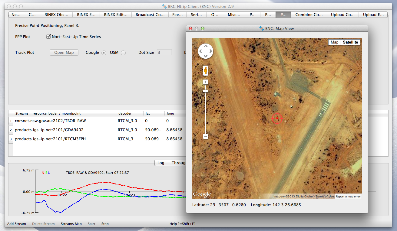
The International GNSS Service (IGS) has published a new version of the Open Source BKG NTRIP Client (BNC) for real-time GNSS applications and RINEX3 QC.
Follow this IGS link to download precompiled binaries for Linux and Windows systems. Version 2.11.0 includes a bug fix for GLONASS code biases as well as RTCM SSR message updates for PPP. The maximum number of GNSS observations has been increased and the loss of lock handling modified. Also, BNC now supports raw stream output through TCP/IP port.
The source code is available via SVN software archive. A Mac binary is under preparation.
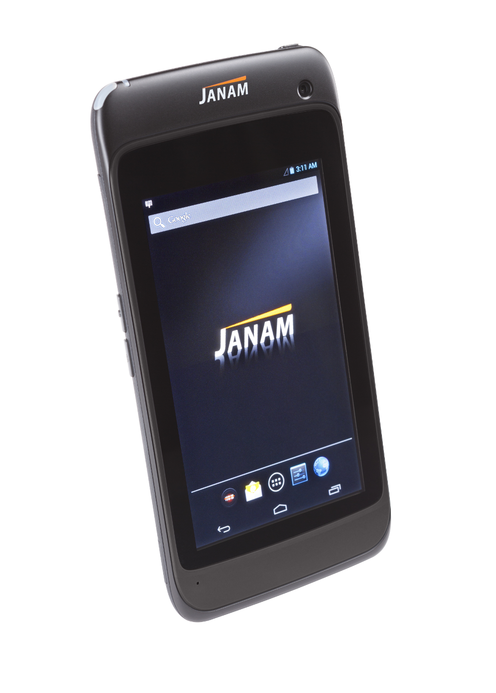
Janam Technologies LLC, a provider of rugged mobile computers that scan barcodes and communicate wirelessly, has launched XT1, a powerful rugged tablet for the mobile workforce. The XT1 rugged mini-tablet is Janam’s first device to support the Android operating system, and is built to meet the diverse needs and demanding requirements of enterprise and government customers.
The XT1 combines best-in-class technologies with a sleek and rugged form factor, providing mobile workers with the information they need to make better informed decisions, increase customer satisfaction, and improve operational efficiencies, the company said. Equipped with integrated 2D barcode scanning technology to eliminate the challenges often associated with camera scanners or bulky sled attachments, the XT1 is designed to improve worker productivity in field sales, field service, healthcare, hospitality and retail markets.
“Many enterprise customers require more screen viewability than traditional PDAs or handheld computers offer, yet full-display rugged tablets are large, thick, heavy and unwieldy,” said Harry B. Lerner, CEO of Janam. “Janam resolves this dilemma. The XT1 blends cutting-edge technologies most often found in consumer phones with mission-critical key features that enterprises need such as ruggedness, sealing, barcode scanning and rapid battery recharging, among others. The result is a sleek, lightweight, rugged mini-tablet that delivers superior performance without sacrificing usability.”
In addition to 4G-ready UMTS/HSDPA/HSUPA/GSM wireless wide-area network communication, the XT1 is equipped with 802.11a/b/g/n dual-band WLAN for access to the information mobile workers need to get the job done, inside and outside the four walls. With IP54 sealing and the ability to withstand repeated three-foot drops to concrete, the XT1 delivers the reliability needed to excel in the most demanding environments, Janam said.
XT1 features include:
Android 4.2 operating system
TI OMAP4470 @ 1.5GHz
5.9-inch WVGA TFT capacitive touchscreen
High-performance 2D data capture
Multiple 3-foot/1-meter drops to concrete
IP54 sealing against environmental elements
Embedded RFID and NFC capabilities
Optional3G/4G WWAN technology (UMTS/HSDPA/HSUPA/GSM)
1GB RAM, 16GB ROM
Wi-Fi 802.11a/b/g/n
Bluetooth 4.0 (BLE)
High-sensitivityGPS and Assisted GPS
Motion sensing accelerometer
Front/rear cameras
User-accessible microSD card slot
3.5mm headset jack
MicroUSB connector
3000mAh rechargeable LiIon battery